Temperate Sierras ecoregion
Contents
Temperate Sierras ecoregion (CEC)
| Topics: |
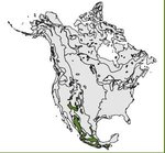 Map of the Temperate Sierras ecoregion.
 This ecological region comprises the major Mexican mountains including the Western Sierra Madre, the Eastern Sierra Madre, the Nudo Mexteco in western Oaxaca and Chiapas. Overall, the region covers approximately 25 percent of the land area of Mexico. Many of the major cities of the country are located here, including Mexico, Guadalajara, Morelia, Toluca and Puebla. Approximately 40 million people inhabit this region of intensive agricultural and industrial use.
Physical Setting
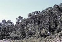 Temperate cloud forest in the Eastern Sierra Madre. (Photo: F. Takaki)
 The bedrock is a mix of igneous (Neovolcanic belt and Western Sierra Madre), metamorphic (Southern Sierra Madre) and sedimentary (Eastern Sierra Madre) rock. Mountains, canyons and foothills are dominant. The Western Sierra Madre is one of the largest volcanic ranges of the world, being some 1,250 kilometers (km) long and ranging from 125 to 300 km wide, with ppelevation[[up to 3,000 [../154588/index.html meters]] (m) above sea level. Major ranges include: Sierra Tarahumara, Papasquiaro Tepehuanes, Sombrerete. Predominant drainage is toward the Pacific Ocean. The Conchos River and the inner basin of Nazas-Aguanaval are also important in the hydrological system.
The Eastern Sierra Madre chain, from 60 to 200 km wide, attains a height of 3,900 m above sea level and stretches for 1,000 km. It consists of mountains and folded hills, as well as valleys and plains. The most prominent mountains include: Arteaga, Gorda and La Huasteca. The Neovolcanic Belt, stretching from the Pacific Ocean to the Mexican Gulf, is 880 km long and 130 km wide. It includes the highest peaks of Mexico, including Pico de Orizaba, Iztaccíhuatl and Popocatépetl (more than 5,000 m high), and contains a number of active volcanoes. An intricate drainage system is found throughout the region, of which the Lerma-Santiago system is the largest component. Major lakes include Pátzcuaro, Chapala and Cuitzeo.
Biological Setting
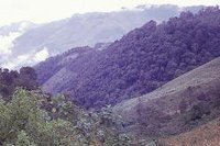 Pine forest in the Neovolcanic Belt. (Photo: F. Takaki)
 Vegetation can be evergreen or deciduous, primarily being composed of conifers and oaks. They grow from 10 to 30 m, sometimes reaching 50 m. This vegetative cover may comprise from one to three tree layers, one or two shrub layers and a herbaceous stratum. A mountain cloud forest occurs in places. This forest community is characterized by about 3,000 vascular plant species, 30 percent of which are endemic to Mexico. Mexican beech is a relict in Mexico. There are about 40 species of pine and more than 150 species of oak in Mexico—more than anywhere else in the world.
The mountain cloud forest is very rich in the diversity of vertebrate species. However, of the 298 species that inhabit these forests, 15 are endangered (IUCN Red List Criteria for Endangered). Due to the reduced available cover (about 3 percent of the Mexican surface) and the high rates of deforestation to which this system has been subjected, it is probable that many other species with a restricted distribution are also close to extinction.
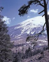 High altitude pine forest on the slopes of the Popocatepetl volcano in Mexico. (Photo: F. Takaki)
 Of all the species of Mesoamerican vertebrates, 23 percent live in the coniferous forests of this region. Six percent of these species inhabit only these forests. From a total of 294 vertebrate species, 20 are officially listed as endangered. Mammals on this list include: wolf, coyote, cougar, squirrels, rats and mice. Listed birds include hummingbirds and woodpeckers. In the south of Mexico and Central America above elevations of 1,000 m, amphibians are more prevalent than reptiles.
Human Activities
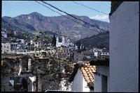 Taxco, one of the many colonial mining towns established in the Temperate Sierras.(Photo: J. Stoub)
 This ecological region has been particularly affected by human activities, such as agriculture and industry. It produces 80 percent of Mexico’s wood supply. In terms of agriculture, common crops are corn, beans, barley, wheat and oatmeal. The prominent fruit trees are peach, apple and avocado, and, in some parts, coffee. Other important crops are potatoes, prickly pear and vegetables like squash and broad beans. Overall, this region accounts for 20 percent of Mexican agriculture. Specifically, it has 8 percent of the country’s cattle, 64 percent of the corn crop, as well as 19 percent of the bean and 63 percent of the barley crops. These crops occupy 70 percent of the agricultural surface of the region. Besides cattle-raising, sheep and goat farming is prevalent.
The region’s coniferous [[forest]s] are threatened because of inappropriate forest harvesting and management practices. Fires are part of the natural process of forest regeneration. Nevertheless, in Mexico, fire is widely used as a tool for converting land from one use to another. This results in upsetting natural cycles of fire and an increase in the frequency of fire. About 40 percent of the region has been transformed. As a result, species such as Chiapas pine and Mexican piñon are close to extinction.
Culturally, the region has a long history associated with the Aztec, Zapotec, Mixtec, Purépecha and Otomí peoples. With the Spanish arrival, the region became a center for colonial development. More than 2 million inhabitants are indigenous. Twenty percent of this population is engaged in agricultural activities.
The Metropolitan area of Mexico City, one of the most populous urban areas in the world, is inhabited by about 20 million people and, with the other large cities in this region, adds up to about 40 million (almost 40 percent of the total Mexican population). This populace represents a huge demand for goods and services that must be satisfied with products imported from other regions. The high concentration of industries and commerce attract people to the city from other parts of the country. This migration has resulted in unequal economic growth which, in turn, has caused major social problems.
| Disclaimer: This article is taken wholly from, or contains information that was originally published by, the Commission for Environmental Cooperation. Topic editors and authors for the Encyclopedia of Earth may have edited its content or added new information. The use of information from the Commission for Environmental Cooperation should not be construed as support for or endorsement by that organization for any new information added by EoE personnel, or for any editing of the original content. |