Svalbard
| Topics: |
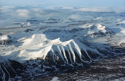
Spitsbergen, part of the Svalbard archipelago. Source: Jerzy Strzelecki/Wikimedia Commons
Countries and Regions of the World Collection  Svalbard is an archipelago between the Arctic Ocean, Barents Sea, Greenland Sea, and Norwegian Sea, north of Norway. Svalbard is the northernmost part of the Kingdom of Norway. It consists of nine main islands including Spitsbergen and Bjornoya (Bear Island). It is home to about 2,000 people.
Glaciers and snowfields cover 60% of the total area.
|
|
|
|


Spitsbergen Island is the site of the Svalbard Global Seed Vault, a seed repository established by the Global Crop Diversity Trust and the Norwegian Government
The islands are mostly covered by wild, rugged mountains and much of high land is ice covered. The west coast is clear of ice for about one-half of the year. There are fjords along west and north coasts.
Ice floes often block the entrance to Bellsund (a transit point for coal export) on the west coast and occasionally make parts of the northeastern coast inaccessible to maritime traffic.
There are no trees; the only bushes are crowberry and cloudberry.
First discovered by the Norwegians in the 12th century, the islands served as an international whaling base during the 17th and 18th centuries.
Norway's sovereignty was recognized in 1920; five years later it officially took over the territory.
Despite recent discussions, Russia and Norway dispute their maritime limits in the Barents Sea and Russia's fishing rights beyond Svalbard's territorial limits within the Svalbard Treaty zone.
Geography
Location: Northern Europe, islands between the Arctic Ocean, Barents Sea, Greenland Sea, and Norwegian Sea, north of Norway
Geographic Coordinates: 78 00 N, 20 00 E
Area: 62,045 sq km. Note: includes Spitsbergen and Bjornoya (Bear Island)
Coastline: 3,587 km
Maritime Claims:
exclusive fishing zone: 200 nm unilaterally claimed by Norway but not recognized by Russia
Natural Hazards: ice floes often block the entrance to Bellsund (a transit point for coal export) on the west coast and occasionally make parts of the northeastern coast inaccessible to maritime traffic
Terrain: wild, rugged mountains; much of high land ice covered; west coast clear of ice about one-half of the year; fjords along west and north coasts. The highest point is Newtontoppen (1,717 m).
Climate: arctic, tempered by warm North Atlantic Current; cool summers, cold winters; North Atlantic Current flows along west and north coasts of Spitsbergen, keeping water open and navigable most of the year
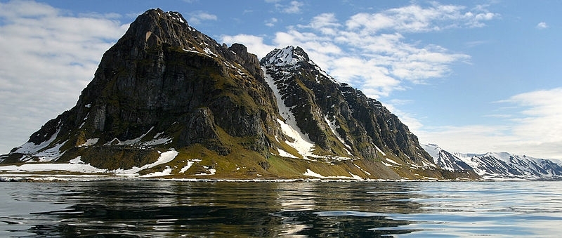
Prince Charles Forland/Forlandet National Park. Source: Per Harald Olsen/Wikimedia Commons
Ecology and Biodiversity
Ecologically, Svalbard is within the Arctic desert ecoregion, a biome with precipitation below 250 millimeters per annum and a mean temperature during the warmest month of less than 10 degrees Celsius. Typically occurring at higher latitudes than tundra biomes, polar deserts occupy approximately 5,000,000 square kilometers of land surface, chiefly comprised of exposed bedrock, talus or rocky plains. In the northern hemisphere this biome is often termed the High Arctic. The soils regime of the polar desert is generally characterized by occurrence of permafrost.
- Fisheries and aquaculture in the Northeast Atlantic (Barents and Norwegian Seas)
- Managing biodiversity conservation in a changing environment of the Arctic
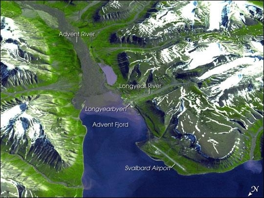
Spitsbergen, the largest of the islands in the Svalbard Archipelago, sits well inside the Arctic Circle, just south of 80 degrees north latitude. This image of the island and its topography was captured by NASA's Terra satellite. The rugged mountains are capped with snow and glaciers, with only the river valleys and low elevations supporting vegetation. Braided, shallow rivers filled with glacial sediment occupy the valleys. The vertical scale is exaggerated by a factor of two to emphasize the rugged terrain. The small town of Longyearbyen serves as the capital; its small airport provides the most northerly public airline service on earth. Although coal mining is still an important economic activity on the frigid island, scientists have recently become as interested in what can be tucked away in the frozen mountains of Spitsbergen as what can be extracted from them. In late February 2008, Norway accepted the first deposit for a so-called "Doomsday" agricultural seed vault, drilled deep into the mountains overlooking the Svalbard Airport. Financed by Norway, the Svalbard Global Seed Vault will safeguard seeds of human food crops from all over the world in the event a natural or human-caused catastrophic event would threaten the human food supply. Photo courtesy of NASA.
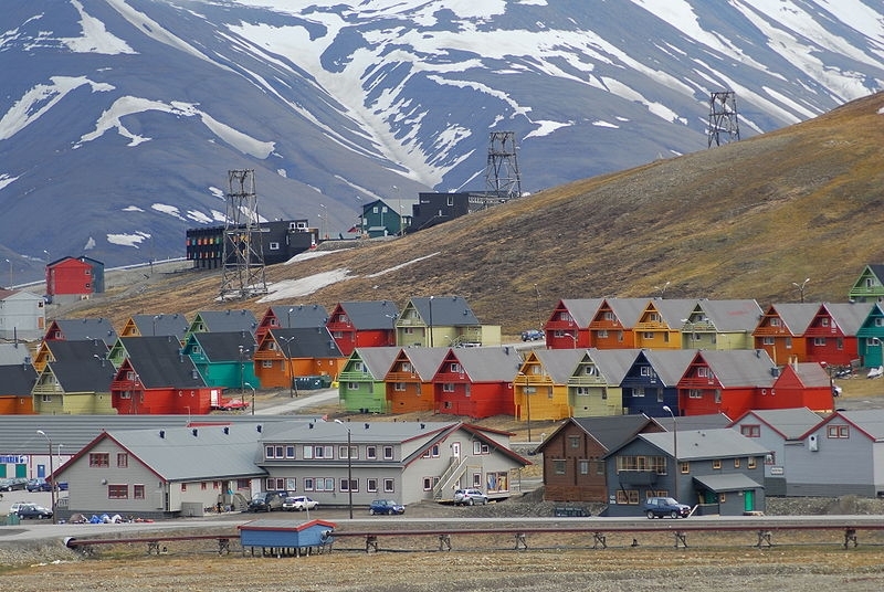
Rows of multicoloured homes in the town of Longyearbyen. Source: Svalbard Global Seed Vault/Peter Vermeij
Dependency Status: territory of Norway; administered by the Polar Department of the Ministry of Justice, through a governor (sysselmann) residing in Longyearbyen, Spitsbergen; by treaty (9 February 1920) sovereignty was awarded to Norway
Capital: Longyearbyen
Legal System: the laws of Norway where applicable apply
Population: 1,970 (July 2012 est.)
Ethnic Groups: Norwegian 55.4%, Russian and Ukrainian 44.3%, other 0.3% (1998)
Population Growth Rate: -0.025% (2012 est.)
Natural Resources: coal, iron ore, copper, zinc, phosphate, wildlife, fish
Coal mining, tourism, and international research are the major revenue sources on Svalbard. Coal mining is the dominant economic activity and a treaty of 9 February 1920 gave the 41 signatories equal rights to exploit mineral deposits, subject to Norwegian regulation.
Although US, UK, Dutch, and Swedish coal companies have mined in the past, the only companies still engaging in this are Norwegian and Russian.
The settlements on Svalbard are essentially company towns.
The Norwegian state-owned coal company employs nearly 60% of the Norwegian population on the island, runs many of the local services, and provides most of the local infrastructure.
There is also some hunting of seal, reindeer, and fox.
Currency: Norwegian kroner (NOK)
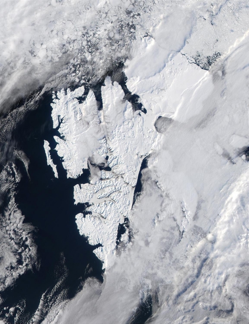
Photo courtesy of NASA.

Topography of Svalbard. Source: Wikimedia Commons.