South China Sea large marine ecosystem
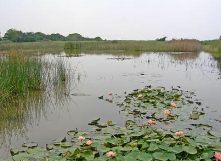
Mai Po Marsh fringe of the South China Sea. @ C.Michael Hogan
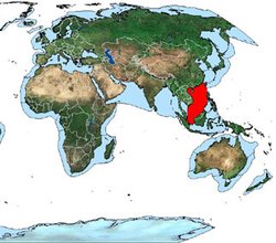 Location of the South China Sea Large Marine Ecosystem (Source: NOAA)
 The South China Sea Large Marine Ecosystem (Large marine ecosystems) (LME) is characterized by its tropical climate. Different sub-systems within the ecosystem have been identified (see Pauly and Christensen, 1993). Vietnam, China, Taiwan, the Philippines, Malaysia, Thailand, Indonesia and Cambodia are the eight countries bordering the South China Sea LME. The Gulf of Thailand has been designated as a separate LME. Intensive fishing is the primary force driving the South China Sea LME, with climate as the secondary driving force. The Global Environment Facility (GEF) is supporting an LME project in the South China Sea to address critical threats to the coastal and marine environment, and to promote ecosystem-based management of coastal and marine resources. An LME article pertaining to this LME is Pauly and Christensen, 1993, which in the absence of a single comprehensive model that can predict interactions within the LME and its evolution through time, proposes 10 models of ecosystem dynamics.
Contents
- 1 Productivity
- 2 Fish and Fisheries
- 3 Pollution and Ecosystem Health
- 4 Islands and Reefs
- 5 Socioeconomics
- 6 Governance
- 7 References
- 7.1 Articles and LME Volumes FAO, 2003. Trends in oceanic captures and clustering of large marine ecosystems—2 studies based on the FAO capture database. FAO fisheries technical paper 435 (South China Sea large marine ecosystem) . 71 pages. * Pauly. D. and Villy Christensen, 1993. "Stratified Models of Large Marine Ecosystems: A General Approach and an Application to the South China Sea," in Kenneth Sherman, et al. (eds.) Large Marine Ecosystems: Stress, Mitigation, and Sustainability (Washington, D.C.: American Association for the Advancement of Science) pp.148-174. ISBN: 087168506X.
- 7.2 Other References
- 7.3 Citation
Productivity
Habitats in the South China Sea include mangrove forests, seagrass beds, coral reefs and soft-bottom communities. The 50-meter depth contour largely follows the coast, with the widest shelves occurring along the eastern edge of the LME. For a map of the LME, with 50 and 200 meters (m) isobaths and major coralline areas, see Pauly and Christensen, 1993. The South China Sea is a biologically diverse marine ecosystem. It is considered a Class II, moderately high productivity (150-300 grams of carbon per square meter per year) ecosystem based on SeaWiFS global primary productivity estimates. High productivity levels are found in gulfs, along the coast, and in reef and seagrass areas, common in the Philippines portion of the LME. For generalizations about primary production based on modeling results, see Pauly and Christensen, 1993. Production decreases with depth. For a study of productivity in the Southwestern South China Sea (eastern peninsula of Malaysia and southeastern Sumatra).
Fish and Fisheries
The Food and Agriculture Organization (FAO) 10-year trend shows a steady increase in total catch, from six million tons in 1990 to 13.5 million tons in 1999. The average level is 10 million tons. The greater marine biodiversity of tropical regions is reflected in catch composition.
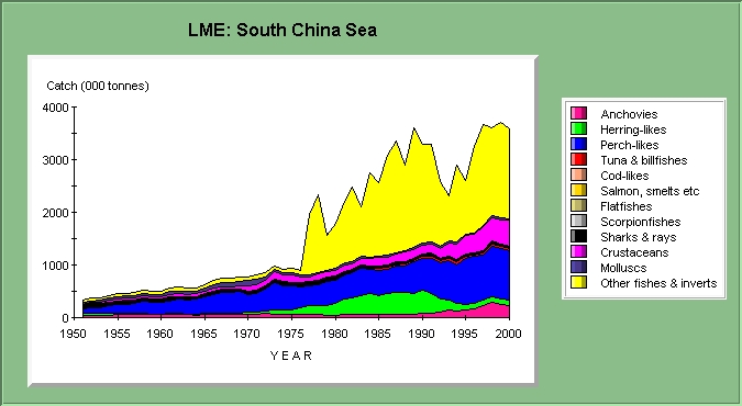 Graph: LME: South China Sea (Source: NOAA)
 Catches of crustaceans represent about 22% of the total catch. Five of the countries are among the top eight shrimp producers of the world. There is also a high catch percentage for miscellaneous coastal fishes and pelagic fishes (tuna, yellowfin, big eye and skipjack). Herrings, sardines and anchovies represent about 13% of the catch (see FAO, 2003). For catch estimates and catch potential based on modeling results, see Pauly and Christensen, 1993. The Global International Waters Assessment (GIWA) has issued a matrix that ranks LMEs according to the sustainable exploitation of fisheries (Fisheries and aquaculture) and the predicted direction of future changes. GIWA characterizes the LME as severely impacted in terms of overfishing, with severe socioeconomic and community consequences, excessive bycatch and discards, and destructive fishing practices, which include cyanide and dynamite fishing, and the use of small-meshed nets. These impacts show no changes (see the GIWA web site). While two thirds of the major fish species are overexploited, carefully constructed fishing regimes could result in increased catches (see Pauly and Christensen, 1993). The deeper coralline areas and those situated in the central portion of the LME are only slightly exploited, leaving room for an increase in production (see Alcala, 1981; and White 1989). However, these areas are more difficult to fish. The University of British Columbia Fisheries Center has detailed fish catch statistics for this LME.
Pollution and Ecosystem Health
 (Source: NOAA)
 Ecosystem health is affected by coastal and economic development. 270 million people (five percent of the world’s population) live in the [[coastal] areas] of the LME. This population is expected to double in the next three decades. GIWA characterizes the LME as severely impacted in terms of habitat and community modification (loss of ecotones, having socioeconomic and community impacts). These impacts show no changes in the high degree of adverse impact. The main environmental threats are: sewage pollution, destructive fishing practices, overfishing, the destruction of mangrove forests, coral reef degradation, and damage to sea grasses and wetlands. 65% of mangrove forests have been lost to shrimp farms, industrial areas or tourist resorts. The mangroves are chopped up for wood chips or firewood. Their disappearance on such a large scale has led to sediment erosion, water pollution, loss of biodiversity and a critical loss of nursery habitat for young fish. Climate change and an increase in the sedimentation of the many major rivers flowing into the LME are impacting corals. GEF and UNEP are assisting to restore and protect the globally significant coral reefs, sea grass beds, mangroves and wetlands of this LME and its coast. UNEP supports the COMEMIS project (coastal marine environment management information system). This is designed to improve the region’s capacity to make sound environmental assessments through GIS. The GEF-funded project PEMSEA (Partnerships for environmental management of the seas of East Asia) conducts hotspot remediation activities. See the Global Environmental Facility (GEF) and the United Nations Environment Programme (UNEP) for the GEF-funded land-base sources of pollution project.
Islands and Reefs
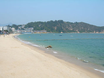 Beach at Chung Chau Island in the South China Sea. @ C.Michael Hogan The South China Sea currently exhibits more than 250 small islands, atolls, reefs, shoals, skerries and sandbars, most of which are uninhabited; of the total they fall into the categories of fully submerged, tidally submerged and fully emergent. These island landforms can be classified into a few major archipelagos, notable of which are the Macclesfield Bank, Spratly Islands, Pratas Islands, Paracel Islands and Scarborough Shoal. The Spratly Islands alone cover an areal extent of about 720,000 square kilometers and comprise around 175 distinct insular landforms, the largest island of which is Taiping, which has a length of 1.3 kilometres and a maximum elevation of 3.8 metres; however, the largest individual feature in the Spratly regime is located at the northeast of the Spratly: 100 kilometre long seamount termed Reed Bank, which is divided away from the Philippines island of Palawan by the Palawan Trench. Presently inundated to a depth of twnty metres, this landform was an island up to 5000 BC, prior to the sea level rise of the Holocene. Having an areal extent of approximately 8870 square kilometers, the Reed Bank is considered one of the most extensive submerged atolls in the seas of the world.
Socioeconomics
The South China Sea LME contributes to the livelihood of millions of people engaged in fisheries (Fisheries and aquaculture), trade, tourism, industry, and oil exploitation The coastal and estuarine areas off of Vietnam, China and Cambodia are historically very productive from a fisheries perspective. In the past, a substantial fraction of Vietnamese fisheries was artisanal. Vietnam’s demersal resources were exploited primarily by Taiwanese vessels. The Northwestern coast of the Philippines is a soft-bottom area fished intensively by trawlers (see Silvestre et al., 1989). The deep shelf areas of the South China Sea are fished by Taiwanese vessels (see Yeh, 1981). The LME according to GIWA is severely impacted in terms of overfishing, with severe socioeconomic and community consequences. The ongoing depletion of the LME’s marine resources will adversely affect the region’s economy. The area’s rapid economic development and its population growth are causing significant ecological damage in coastal and marine areas. The South China Sea LME is the world’s second busiest international sea lane.
Governance
 (Source: NOAA)
 Eight nations (Cambodia, China, Taiwan, Indonesia, Malaysia, Philippines, Thailand and Vietnam) are involved in the governance of the South China Sea LME, sharing concerns about the marine environment and an awareness of the importance of the Sea as a source of protein for the growing coastal [[population]s]. The entire region is experiencing a phase of rapid economic development and population growth. This has sharpened conflicts within governments such as China. Moreover, several of the countries have contending claims to large areas of the South China Sea, leading to political tensions among them. The claims are about the status of the Paracel Islands and the Spratly Islands, which are said to contain minerals, oil and gas resources. However, seven countries have agreed to collaborate in the protection of the marine environment. In 2001, they signed a joint agreement to a regional plan sponsored by the United Nations Environment Program (UNEP). The plan will address the degradation of the South China Sea by starting 9 pilot projects for sustainable development at priority transboundary sites in the region. The Global Environment Facility (GEF) is contributing $16 million dollars to this plan. The GEF funding will help build human and institutional capacity. Environmental laws and regulations are being formulated. The GEF provides assistance to the Mekong Basin Project with its valuable delta. The 7 countries are developing an ecosystem-based approach to management through the creation of a Transboundary Diagnostic Analysis (TDA), a science-based analysis of transboundary concerns and their root causes, leading to the setting of priorities for action in a Strategic Action Programme (SAP). For a map of the area and information on managing potential conflicts in the South China Sea LME, on the status of conventions, and for a transboundary diagnostic analysis for this LME, see the University of Oslo web site.
References
Articles and LME Volumes FAO, 2003. Trends in oceanic captures and clustering of large marine ecosystems—2 studies based on the FAO capture database. FAO fisheries technical paper 435 (South China Sea large marine ecosystem) . 71 pages. * Pauly. D. and Villy Christensen, 1993. "Stratified Models of Large Marine Ecosystems: A General Approach and an Application to the South China Sea," in Kenneth Sherman, et al. (eds.) Large Marine Ecosystems: Stress, Mitigation, and Sustainability (Washington, D.C.: American Association for the Advancement of Science) pp.148-174. ISBN: 087168506X.
Other References
- Alcala, A.C. 1981. Fish yields of coral reefs of Sumilon Island, Central Philippines, Nat. Resource Counc. Philipp. Res. Bull. 36(1):1-7. Annual Fishery Statistics. Dept. of Fisheries Malaysia. Kuala Lumpur, Malaysia (various years).
- Blackburn, M. 1981. Low latitude gyral regions. In: Analysis of marine ecosystems. Pp.3-29. Ed. byA.R. Longhurst. Academic Press. San Diego. ISBN: 0124555608.
- Buku Tahunan Statistik Perikanan (Fishery Yearbook). DINAS PERIKANAN. Denpasar, Indonesia (various years).
- Dokken, K. 2001. "Environment, Security and Regionalism in the Asia Pacific: Is Environmental Security a Useful Concept?", paper presented under panel 1: The Environment, Energy and Maritime Affairs at the conference "Human and Regional Security around the South China Sea", Oslo 2-4 June 2000.
- Eiamsa-Ard, M. and S. Amornchairojkul, 1997. The marine fisheries of Thailand, with emphasis on the Gulf of Thailand trawl fishery. p. 85-95 In: G. Silvestre and D. Pauly. (eds.). Status and Management of tropical coastal fisheries in Asia. ICLARM Conf. Proc. 53. ISBN: 9718709029.
- Fisheries Statistical Yearbook Taiwan Area. Fisheries Admin. Council of Agriculture. Taiwan (various years).
- Food and Agriculture Organization (FAO). 1981. Atlas of the living resources of the seas. FAO Fisheries Series. Rome. ISBN: 9250010001.
- Liew, H.C. and Chan, E.H. 1987. ECOPATH model of a tropical shallow-water community in Malaysia. Manuscript submitted to International Development Research Center (IDRC)/Singapore.
- Næss, T. 1999. Epistemic Communities and Environmental Co-operation in the South China Sea. In Knut Snildal (Comp.): Perspectives on the Conflict in the South China Sea, SUM Workshop Proceedings, August 1999.
- Næss, T. 2000. Environment and Security in the South China Sea Region: The Role of Experts, Non-Governmental Actors and Governments in Regime Building Processes. A thesis for the Cand. Polit. degree at the Department of Political Science, University of Oslo, December 1999. Published in the SUM Dissertations & Thesis series as No. 1/2000 (ISSN 0806-475X)
- Næss, T. 2000. "Environmental co-operation around the South China Sea. The experience of the South China Sea Workshops and the United Nations Environment Programme's Strategic Action Programme. Paper presented under panel 1: The Environment, Energy and Maritime Affairs at the conference "Human and Regional Security around the South China Sea", Oslo 2-4 June 2000
- Nguyen, TacAn. 1989. Energy balance of the major tropical marine shelf ecosystem of Vietnam. Biologiya Morya (Sov. J. Mar. Biol.)15(2):78-83.
- Pauly, D. 1979. Theory and management of tropical multispecies stocks: A review, with emphasis on the Southeast Asian demersal fisheries. ICLARM Studies and Reviews No. l.
- Rowe, G.T. 1981. The deep-sea ecosystem. In: Analysis of marine ecosystems. Pp.235-267. Ed. By A.R. Longhurst. Academic Press. San Diego. ISBN: 0124555608.
- Shindo, S. 1973. General review of the trawl fishery and the demersal fish stocks of the South China Sea. FAO Fish Tech. Pap. 120. FAO, Rome.
- Silvestre, G., et al. 1989. Towards sustainable development of the coastal resource of Lingayen Gulf, Philippines. ICLARM Conference Proceedings 17.
- Silvestre, G, et al. 1990. Preliminary trophic model of the coastal fishery resources of Brunei Darussalam, South China Sea. ICES CM 1990/L:41 Sess. Q.
- South China Sea Programme. 1978. Report of the workshop on management of resources in the Sunda Shelf, Malacca Strait and related areas. South China Seas Fisheries Development and Coordinating Programme. SCS/GEN/78/18, Manila.
- White, A.T. 1989. Two community-based marine reserves: Lessons for coastal management. In: Coastal area management in Southeast Asia: Policies, management strategies and case studies. Pp.85-96. Ed.by T.E. Chua and D.Pauly. ICLARM Conference Proceedings 19. ISBN: 9711022761.
- Wyrtki, K. 1961. Dynamics of the demersal fish resources in the Sunda Shelf area of the South China Sea. Ph.D. diss., University of Washington, Seattle.
- Yeh, S.A. 1981. Dynamics of the demersal fish resources in the Sunda Shelf area of the South China Sea. Ph.D. diss., University of Washington, Seattle.
| Disclaimer: This article contains some information that was originally published by the U.S.National Oceanic and Atmospheric Administration (NOAA). Topic editors and authors for the Encyclopedia of Earth have edited its content and added new information. The use of information from the NOAA should not be construed as support for or endorsement by that organization for any new information added by EoE personnel, or for any editing of the original content. |