Siwa Oasis (About the EoE)
Contents
Siwa Oasis
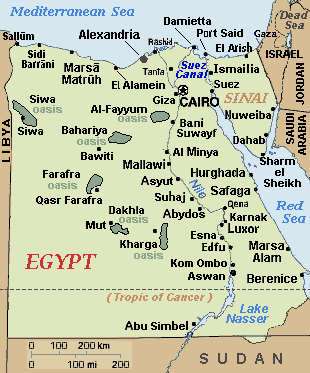
The Siwa Oasis is located in the northern and eastern part of the Sahara Desert (the Libyan Desert or Western Desert) in western Egypt close to the border of Libya.
 Egyptian Oases in Libyan Desert
The name "Siwa Oasis" is used synonymously with "Siwa Depression", a basin containing five significant lakes ("birket") and about five smaller ones.
Geography
The Siwa Oasis is located west of the Qattara Depression between lattitudes 29°02' and 29°28' North and longitudes 25°12' and 26°02' East; about 525 kilometers (km) from Cairo and 300 km south (inland) from the Mediterranean Sea. Immediately to its south lies the Great Sand Sea.
The Siwa Depression is irregularly shaped and extends, at its maximimum, 82 km long and 28 km wide covering approximately 1,088 km2, of which 70 km2 is open water and 100 km2 is marshland. At its lowest point, it has an elevation about 25 meters (m) below sea level.
Hughes and Hughes (1992) report suggests:
The depression has developed on limestones of Eocene and Miocene age, and is bounded by steep slopes on the northern side, reaching about 120 to160 meters (m) above sea-level and by much gentler slopes to the south and southeast. Here, slopes rise onto the plateau of the Western Desert which comprises limestone covered by wind blown sands.
A number of small basins on the floor of the depression hold lakes, about a dozen in total, many of which are surrounded by extensive marshes. The present lakes are the remnants of once larger large water bodies that existed during the Pleistocene Ice Age. Fossil shorelines of the Pleistocene lakes can be found at altitudes of 8 to 12 m below sea-level. The levels of the present lakes fluctuate seasonally with some of the lakes drying up completely during the summer season.
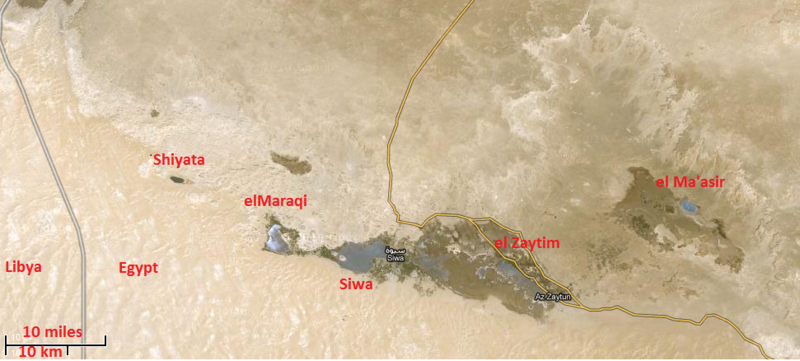
The principal lakes, some of which are not named, are situated at:
- 29°20'N/25°09'E (Shiyata -250 ha);
- 29°13'N/25°18'E (elMaraqi -900 ha);
- 29°13'N/ 25°28'E (Siwa -3200 ha);
- 29°14'N/25°35'E;
- 29°11'N/25°39'E;
- 29°12'N/25°40'E;
- 29°11'N/25°43'E (el Zaytim -1600 ha);
- 29°21'N/25°55'E;
- 29°18'N/25°59'E;
- 29°17'N/ 25°59'E;
- 29°17'N/26°01'E (el Ma'asir -400 ha); and
- 29°14'N/26°04'E.
 The five largest lakes in the Siwa Depression are named in red. The depression itself can be identified by the change in color caused by the change in terrain. Source: Modified from Goole Maps
Mean annual precipitation in the depression is on average 8 mm, but many years are rainless. Temperatures may exceed 48°C in summer, while frosts are not uncommon on the surrounding limestone plateau during the winter season.
Annual potential evaporation (Class A Pan) often exceeds 2300 mm. Relative humidity is generally very low 15-30%, but this may increase to 50% at night, and may fall to 1% when the hot dry Khamsin wind blows in summer.
The landscape of this region sof the world is shaped largely wind erosion and deposition (eolian processes) When the force of wind is concentrated on a particular spot in the landscape, erosion can carve out a pit known as a deflation hollow. Deflation hollows range in size from a few meters to a hundred meters in diameter, and may develop over several days or a couple of seasons. Much larger depressions are also found. These broad, shallow depressions, called pans, can cover thousands of square kilometers. The Qattara Depression, east of Siwa is one of the largest pans in the world, while Siwa itself is a smaller pan.
Ecology
Ecologically, Siwa Oasis is included with the Saharan halophytics ecoregion defined by the World Wildlife Fund. This ecoregion is restricted to some suitable semi-desert and desert locations in the northern portion of Africa, in Morocco, Algeria, Tunisia, Libya, Egypt, Western Sahara and Mauritania. The most extensive of the areas are Chott Melghir, Oued Rir Vally, Hodna, Sebkhat Tidikelet, Sebkha of Timimoun, Tefedest, Chott El Djerid and the Qattara and Siwa Depressions in Egypt.
The present lakes cover approximately 70 km2 as well as another 100 km2 of marshland consisting of Phragmites and Typha swamp. The lakes may dry up in the summer, or shrink considerably. All of the lakes are saline, but are supplied with freshwater from underground springs. These springs supply water that is believed to have been underground for 30,000 to 50,000 years.
Only Chara and other algae, as well as a couple of species of fish, are able to survive in the brackish waters of the lakes.
Community
The Siwa Oasis sustains a permanent human population of about 23,000 most of who live in the town of Siwa at the eastern end of the lake of the same name. It is primarily agricultural (famous for its dates and olives) with a growing tourism industry that is drawn to is ancient archeological sites (more below). The people are mostly ethnic Berbers.
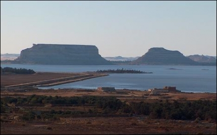
 A panoramic view of the Siwa Oasis in 2005. Source: Vincent Battesti/Wikipedia
History
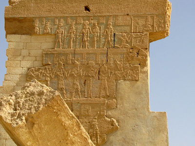
 The last remaining wall of the Temple of Amun at Siwa Oasis. Source: Wikipedia
The oasis is known to have been settled since at least the 10th millennium BC. The earliest evidence of connection with ancient Egypt is the 26th Dynasty (c. 685-525 BC), when a necropolis was established. Herodotus recorded that during the Ptolemaid period of Egypt its ancient Egyptian name was "Field of Trees".
Greek settlers at Cyrene made contact with the oasis around the same time (7th century BC), and the oracle temple of Amun (Greek: Zeus Ammon), who, Herodotus was told, took the image here of a ram. Herodotus knew of a "fountain of the Sun" that ran coldest in the noontide heat. Prior to his campaign of conquest in Persia, Alexander the Great reached the Siwa Oasis, supposedly by following birds across the desert.
A local manuscript mentions only seven families totaling 40 men living at the oasis in 1203.
The first European to visit since Roman times was the English traveler William George Browne, who came in 1792 to see the ancient temple of the oracle.
Further reading
- Byebyenet.com,Siwa Oasis.
- Dunn, J. The History of the Siwa Oasis, TourEgypt.Net.
- Haag, M, 2009. Egypt. Interlink Pub Group. ISBN-10: 1566567963.
- Herodotus. Histories. iv (on-line text).
- Hoskins, G.A. 1837. Visit to the Great Oasis of the Libyan Desert. Longman, Rees, Orme, Green and Longman, London. 341 p.
- Hughes, R. H. and J. S. Hughes. 1992. A Directory of African Wetlands. IUCN, Gland, Switzerland. ISBN-10: 2880329493
- Minamar Hotel, Siwa Oasis.
- Rohlfs G. 1875. Drei Monate in der Libyschen Wüste. (Three Months in the Libyan Desert). Verlag von Theodor Fischer, Cassel. 340 p.
- Scholz, J.M.A. 1822. Travels in the Countries Between Alexandria and Parætonium, the Libyan Desert, Siwa, Egypt, Palestine, and Syria, in 1821. London, 120 p.
- St. John, B. 1849. Adventures in the Libyan Desert and the Oasis of Jupiter Ammon. John Murray, London. 244 p.
Note: This article uses material from the Wikipedia article Siwa Oasis that was accessed on August 23, 2011. The Author(s) and Topic Editor(s) associated with this article may have significantly modified the content derived from Wikipedia with original content or with content drawn from other sources. All content from Wikipedia has been reviewed and approved by those Author(s) and Topic Editor(s), and is subject to the same Peer review process as other content in the EoE. The current version of the Wikipedia article may differ from the version that existed on the date of access. This article is dual-licensed under the Creative Commons Attribution-Sharealike 3.0 Unported License (CC-BY-SA) and the GNU Free Documentation License (GFDL) (unversioned, with no invariant sections, front-cover texts, or back-cover texts).. See the EoE Wikipedia Policy for more information.
