Sechura desert
|
|
The Sechura desert is the most extensive desert strip on the western coast of South America. Although it has been subject to much intervention, it still contains singular plant associations that shelter species (Biodiversity) endemic to the desert such as lomas vegetation. The ecoregion also serves as an important corridor for migratory birds. Human population density is high in this area and although there are a few protected parks, urban expansion poses a major threat to this ecoregion.
Contents
Location and General Description

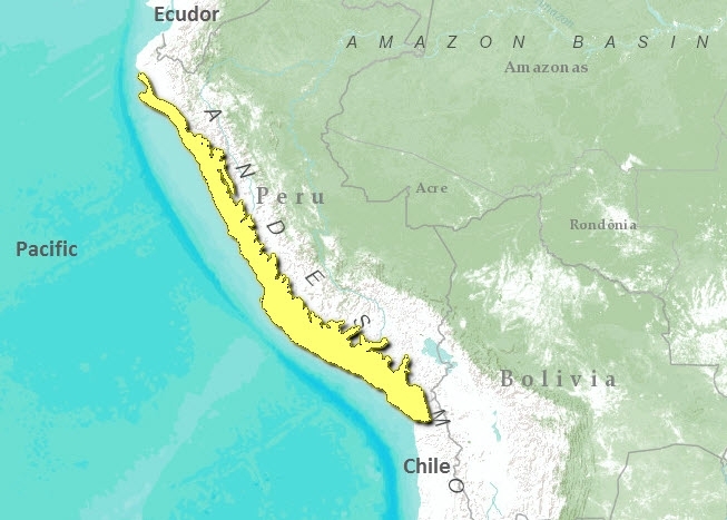
This ecoregion occupies the western subtropical portion of South America in the form of a longitudial coastal strip that extends along 2000 kilometers (km) of Peruvian territory. Due to its location it borders on the west with the Pacific Ocean and on the east extends between 20 and 100 kilometers inland until reaching the Andean secondary ridges, occupying an estimated area of 188,735 square kilometers (km2). Its extremely arid climate is warm in summer and wet in winter, with average annual temperatures of 22 degrees Celsius (?C). Fog is created out at sea and dissipates at elevations between 700 and 1000 meters (m) through the phenomenon of thermal inversion. On the exposed hills and ridges facing southwest, the phenomenon of advective fog occurs, bringing moisture to the desert and leading to lomas vegetation. In the low areas precipitation reaches a maximum of 100 millimeters (mm) per year, while in the higher areas it reaches 200 mm per year. Most of the ecoregion’s geological formations are recent deposits of gravel, sands and clays, but marine outcrops of the lower Cretacean (65-140 million years before present) stand out, with sedimentary volcanic rocks (Composition of rocks) and quarternary fossiliferous deposits. Toward the center of the ecoregion, there are abundant sedimentary deposits of fine grained sandstones with fossiles of molluscs and marine mammals of the Miocene (6-24 million years). The topography is generally flat with extensive plains, areas of dunes and low hills and it is crossed by 52 rivers that empty into the Pacific Ocean.
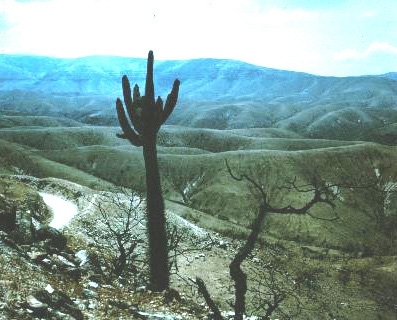
It is characterized by scant plant cover. However, it does have a significant variety of plant formations distributed throughout the ecoregion. Toward the north there is a predominance of carob trees (with nearly exclusive dominance of Prosopis spp.), similar to the Tumbes-Piura Dry Forest ecoregion. In the rest of the ecoregion there are [[coast]al] mountains in the different valleys characterized by the sauce (Salix sp.) and the pájaro bobo (Tessaria sp.); tillandsiales dominated by Tillandsia spp; beach grasses, very close to the coastline in saline soils, where there is a predominance of xerophytic species such as the ‘grama salada’ (Distichlis spicata) and ‘verdolaguilla’ (Salicornia fruticosa); and the hills, where there may be various plant associations and some endemic species of flora and fauna. The characteristic species of the hills are the cardo de lomas (Cactáceas), amancaes (Hymenocallis amancaes), tara (Caesalpinia tara), papaya silvestre (Carica sp.) and others otras. Coastal wetlands are also characteristic of this ecoregion, and near the first foothills of the western range there are some arid, rocky scrublands with abrupt relief, where columnar, candelabra and opuntia cacti typically grow.
Biodiversity Features
Despite the aridity of the area and a relatively low wealth of species (Biodiversity), we find a large number of very specific endemisms, and the different formations throughout the entire ecoregion comprise an important corridor for migratory birds, which also make nests in this area.
Due to the characteristics of the climate, some species of flora have a very specific physiology so that they are able to survive in coastal hill conditions. Species like Tropaelun peltophorum, Drymaria weberbaueri, and Dioscorea chancayensi are endemic to the hill formations. The endemic fauna of the desert include lizards such as Tropidurus peruvianus, T.theresiae, T. Thoracicus, Ctenoblepharis adspersus, the ratón de sechura Phyllotis gerbillus, butterflies of the family Pieridae and an endangered bird like the Phytotoma raymondii.
In the case of birds, there are important migratory movements. Some species come from North America or the Arctic Sanderling (Calidris alba) and Baird’s sandpiper (C. bairdii); others come from North and South America (e.g., Sterna hirundinaceae and Phoenicpterus chilensis) and another group has altitudinal migrations as it comes from the Andean area Puna plover (Charadrius alticola). Threee of the coastal wetlands in this ecoregion are recognized as RAMSAR sites based on their international importance as habitat for migratory species.
Some species (Biodiversity) in this ecoregion are endangered. These include the Chilean Flamingo (Phoenicopterus chilensis), Red-fronted Coot (Fulica rufifrons) and White-winged Guan (Penelope albipennis). However, most of these are included within the range of one of the various protected natural areas that exist in this ecoregion.
Distinctive and restricted range species include Sechura fox (Pseudalopex sechurae), Roedinger's lance head (Bothrops roedingeri), Pizarrita slenderbilled finch Xenospingus concolor, Raimond's Yellow-Finch (Sicalis raimondii), Eugenia ferreyrae, Nolana weissiana, Quinchamalium lomae, Monnina arenicola.
Current Status
Although this ecoregion corresponds to the country’s most populated area, fortunately there are a number of protected natural areas that have a representative sample of the different ecosystems such as the hills, coastal wetlands, desert and the carob groves. In some cases such as the Lomas de Lachay, plant formations in a good state of conservation can still be found. However, it is essential to ensure that the management of these areas is effective and that each area’s conservation objectives are met. In addition, there is still a need to protect important places such as the areas of reproduction of some species and coastal hill areas like the Lomas de Atiquipa.
Types and Severity of Threats
The most serious threat to the ecoregion is the expansion of the urban area, which is rapidly transforming and degrading the natural environment and the few agricultural lands into completely urbanized areas. The principal activities are agriculture, livestock and metallic and non-metallic mining operations. This creates problems of contamination, particularly in the bodies of water in the valleys and coastal wetlands. On the other land, livestock feed on some carab groves in the north and on some coastal hills, leading to overgrazing in both ecosystems. Due to the existence of some birds of interest to hunters such as ducks, there is also illegal hunting although this occurs less frequently.
Despite the network of protected natural areas in the ecoregion, there are still some gaps at this level that should be covered. However, the country’s coast needs not only protected areas but also integrated organization of activities. This has already been started through the National Environmental Council - CONAM and will make it possible to minimize the impact of various productive activities on the ecosystems fo the Sechura Desert ecoregion.
Justification of Ecoregion Delineation
This coastal fog desert flanks the western slopes of the Andes in Peru and Chile. It is bound on the east by the Andes, and on the west by the Pacific Ocean – where the little precipitation which enters this ecoregion, as fog, originates. Our linework follows the Instituto Geográfico Nacional map, from which we lump their classifications of "montane steppe" with "coastal desert of the Peruvian Pacific".
| Disclaimer: This article is contains certain information that was originally published by the World Wildlife Fund. Topic editors and authors for the Encyclopedia of Earth have edited its content and added new information. The use of information from the World Wildlife Fund should not be construed as support for or endorsement by that organization for any new information added by EoE personnel, or for any editing of the original content. |
