Samoa
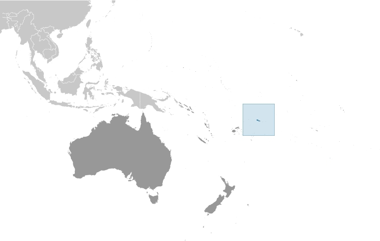
Countries and Regions of the World Collection  Samoa is a nation of nearly 200,000 people which is composed of a group of islands in the South Pacific Ocean, about half way between Hawaii and New Zealand.
The islands of Savai’i and ‘Upolu make up 90 percent of the archipelagos’ land area and are separated from Tutuila and Aunu’u Islands of American Samoa by 64 km of ocean. To the east about 100 km lie Ofu, Olosega, and Ta’u Islands. Even further to the east is the tiny Rose Atoll. The main island of Upolu is home to nearly three-quarters of Samoa's population and its capital city of Apia.
Samoa occupies an almost central position within Polynesia.
Its major environmental issues include:
- soil erosion;
- deforestation;
- invasive species; and,
- overfishing
Samoa is susceptible to occasional typhoons.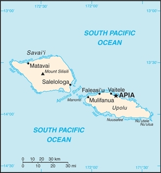
The islands of Samoa comprise the last large areas of land east of Australia in the central Pacific. Their size has helped them accumulate and support a diversity of plant and animal genera not found further to the east as well as a rich, endemic flora and fauna of their own.
About 80 percent of Samoa’s lowland rain forests have been lost during the 3,000 year history of human habitation. Given current trajectories, a devastating loss of native forest is predicted to occur within the next 20 years.
Savai'I Island (elev. 1,858 m), which last erupted in 1911, is an historically active volcano.
New Zealand occupied the German protectorate of Western Samoa at the outbreak of World War I in 1914. It continued to administer the islands as a mandate and then as a trust territory until 1962, when the islands became the first Polynesian nation to reestablish independence in the 20th century. The country dropped the "Western" from its name in 1997.
In the early 1990s, Samoa’s economy suffered blows from two consecutive cyclones (Cyclone Ofa in 1990 and Cyclone Valerie in 1991) and an outbreak of taro leaf blight (a root crop which is the staple food and was the largest export).
In late September 2009, an earthquake and the resulting tsunami severely damaged Samoa, and nearby American Samoa, disrupting transportation and power generation, and resulting in about 200 deaths.
The economy of Samoa has traditionally been dependent on development aid, family remittances from overseas, agriculture, and fishing. Agriculture employs two-thirds of the labor force and furnishes 90% of exports, featuring coconut cream, coconut oil, and copra. The manufacturing sector mainly processes agricultural products. One factory in the Foreign Trade Zone employs 3,000 people to make automobile electrical harnesses for an assembly plant in Australia. Tourism is an expanding sector accounting for 25% of GDP; 122,000 tourists visited the islands in 2007.
Contents
Geography
The Independent State of Samoa includes the western end of the Samoan islands, consisting of the two large islands of Upolu and Savai'i and seven small islets. The island group is located about halfway between Hawaii and New Zealand in the Polynesian region of the South Pacific. The climate is tropical, with a rainy season from November to April.
Location: Oceania, group of islands in the South Pacific Ocean, about half way between Hawaii and New Zealand
Geographic Coordinates: 13 35 S, 172 20 W
Area: 2,831 sq km (land: 2,821 sq km; water: 10 sq km)
Coastline: 403 km
Maritime Claims:
territorial sea: 12 nm
contiguous zone: 24 nm
exclusive economic zone: 200 nm
Natural Hazards: occasional typhoons; active volcanism
Terrain: two main islands (Savaii, Upolu) and several smaller islands and uninhabited islets; narrow coastal plain with volcanic, rocky, rugged mountains in interior. The highest point is Mount Silisili (1,857 m).
Climate: tropical; rainy season (November to April), dry season (May to October)
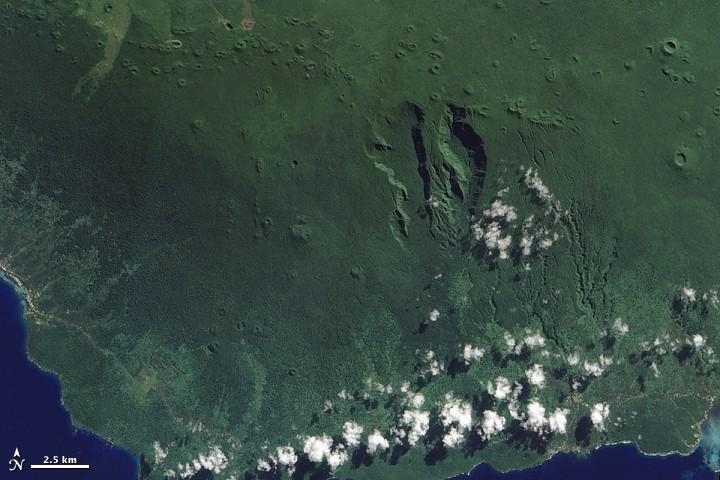
At the western end of the Samoan Island chain lies Savai'i. Stretching over 1,682 sq km (649 sq mi), Savai'i is one of the largest landmasses in Polynesia. The mountainous island is a shield volcano that reaches its highest altitude, 1,858 m (6,095 ft), near the center of the island.
The region's tropical, humid climate sustains vegetation that carpets much of the island. A jagged line of small, round volcanic craters extends east-west across the island (top of image).
South of this uneven line, two deep, parallel valleys extend toward the south. The semicircular contours of the valleys suggest that they might be the remains of an ancient caldera or collapsed magma chamber that was modified by the later eruption of additional lava. With the exception of a few brown crater rims, and a coastal settlement along the image's left edge, the landscape appears in varying shades of green.
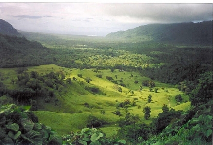
Dense rainforests cover the island's rugged interior, and thick vegetation also thrives along the coastal plains.
Savai'i has remained volcanically active into historical times, with two eruptions occurring in the early 20th century. The eruptions sent big lava flows to the island's northern coast, destroying several villages. Photo courtesy of NASA.
Ecology and Biodiversity
Ecologically, the islands of Samoa are included within the Samoan tropical moist forests ecoregion.
Tropical rain forest once covered all areas, except coastal, salty, marshy, and those that are nutrient-poor. It occurs in three broad types in Samoa: lowland forest is the most extensive, followed by montane forest, and cloud forest, with several other minor habitat types including montane scrub, Pandanus scrub, littoral scrub, montane swamp forests, and summit scrub.
- Lowland rain forest is dominated by Diospyros samoense and D. elliptica, Calophyllum inophyllum, Dysoxylum samoense and D. maota, Pometia pinnata, Planchonella samoense, Syzygium spp., and Myristica fatua.
- The wetter and cooler montane rain forest is dominated by Dysoxylum huntii, but Syzygium spp., Weinmannia spp., Canarium harveyi, Rhus taitensis, and Astronidium spp. are also found.
- Cloud forest occurs above 650 meters in areas almost continually draped in clouds.
Common species are Reynoldsia pleiosperma, Weinmannia samoense, Dysoxylum huntii, and Coprosma savaiiense. The understory contains Dicranopteris linearis, Freycinetia storckii, and Cyathea spp. tree ferns.
There are 536 species of flowering plants with about 28% endemism. There are also 228 fern and allied species. While only one plant genus is endemic (Sacropygme), there are some spectacular groups of plants, including more than 100 species of native orchids. Many genera of plants common in western Pacific forests reach the eastern limit of their distribution in Samoa. Many of Samoa’s plants are restricted to single islands and Blumea milnei, Cordia aspera, and Acronychia retusa are considered threatened or endangered.
Of Samoa’s 37 native land birds, 84 percent are endemic species or subspecies, and there are also 4 introduced species. Large islands in Samoa support up to 6 species of fruit-eating pigeons including the Samoan tooth-billed pigeon (Didunculus strigirostris), a monotypic genus endemic to the islands. The Samoan wood rail (Pareudiastes pacificus) and sooty rail (Porzana tabuensis) are probably extinct. The Australian gray duck (Anas supercilliosia), purple swamphen (Porphyrio porphyrio samoensis), many-colored fruit-dove (Ptilinopus perousii perousii), Samoan ground-dove (Gallicolumba stairi stairi), ma’o (Gymnomyza samoensis), and island thrush (Turdus poliocephalus samoensis) are all endangered or threatened. The Samoan flying fox (Pteropus samoensis) is a CITES-listed species that is endangered by subsistence hunting and by commercial hunting for markets in the western Pacific. There are at least nine species of terrestrial reptiles including geckos and skinks and the Pacific keel-scaled boa (Candoia bibroni).
Since Polynesians arrived around 3,000 years ago, more than 80 percent of lowland rain forest has been lost in Samoa and American Samoa. The Samoan government predicts a total loss of forests within 20 years. Unregulated logging and clearing for subsistence and cash crops are major factors contributing to forest decline. ‘Upolu has the highest human population and, consequently, almost all accessible lowland, montane, and cloud forest has been cleared. Two recent cyclones in 1990 and 1991 killed 53 percent of forest trees, large numbers of forest birds, and facilitated the spread of a wild fire that completely destroyed large areas of forest.
The Robert Louis Stevenson Memorial Reserve/Mount Vaea Reserve (12.9 km2) protects disturbed lowland rain forest. Falealupo Reserve (100 km2) protects one of the largest remaining areas of lowland rain forest. O Le Pupu Pu’e National Park (28 km2) protects rain forest from the top of Mt. Fito, 'Upolu down to sea level. In American Samoa, the National Park of American Samoa (180 km2), defined in 1988, protects tract forest on Tutuila, Ofu, and Ta’u, including a large area of cloud forest on Ta’u. All of these parks experience high levels of poaching as well as encroachment for subsistence agriculture on their borders. Rose Atoll National Wildlife Refuge encompasses the whole uninhabited area of this extremely isolated atoll and protects large numbers of seabirds, but no moist forest.
There is still a need for more extensive reserves in Western Samoa to protect large areas of forest encompassing complete watersheds. In particular, Mount Silisili on Savai’i Island has been cited as a suitable reserve site because of low human population density and high mountains which support a diversity of forests. Savai’i Island is the second highest in Polynesia outside of Hawaii and New Zealand and supports large populations of many of Samoa’s endemic plant and bird species. However, widespread logging and replacement of native forest with teak and mahogany plantations are limiting future conservation options.
Si’ osi’omaga and Ole Vaomatua are two local conservation groups active in the archipelago. Local communities have also been increasingly involved in stopping logging operations and the conservation of forests.
People and Society
Population: 194,320 (July 2012 est.)
The Fa'a Samoa, or traditional Samoan way, remains a strong force in Samoan life and politics. Despite centuries of European influence, Samoa maintains its historical customs, social systems, and language, which is believed to be the oldest form of Polynesian speech still in existence. Only the Maoris of New Zealand outnumber the Samoans among Polynesian groups. There are significant Samoan communities in the United States, New Zealand, and Australia. In general these communities maintain ties with family remaining in Samoa, and still consider themselves to be Samoan.
Ethnic Groups: Samoan 92.6%, Euronesians (persons of European and Polynesian blood) 7%, Europeans 0.4% (2001 census)
Age Structure:
0-14 years: 35.4% (male 35,233/female 33,060)
15-64 years: 59.4% (male 59,366/female 55,376)
65 years and over: 5.2% (male 4,472/female 5,654) (2011 est.)
Population Growth Rate: 0.596% (2012 est.)
Birthrate: 22.1 births/1,000 population (2012 est.)
Death Rate: 5.34 deaths/1,000 population (July 2012 est.)
Net Migration Rate: -10.81 migrant(s)/1,000 population (2012 est.)
Life Expectancy at Birth: 72.66 years
male: 69.79 years
female: 75.68 years (2012 est.)
Total Fertility Rate: 3.13 children born/woman (2012 est.)
Languages: Samoan (Polynesian) (official), English
Literacy (age 15 and over can read and write): 99.7% (2003 est.)
Urbanization: 20% of total population (2010)
History
Migrants from Southeast Asia arrived in the Samoan islands more than 2,000 years ago and from there settled the rest of Polynesia further to the east. Contact with Europeans began in the early 1700s but did not intensify until the arrival of English missionaries and traders in the 1830s. At the turn of the 20th century, the Samoan islands were split into two sections. The eastern islands became territories of the United States in 1904 and today are known as American Samoa. The western islands became known as Western Samoa (now the Independent State of Samoa), passing from German control to New Zealand in 1914. New Zealand administered Western Samoa under the auspices of the League of Nations and then as a UN trusteeship until independence in 1962. Western Samoa was the first Pacific Island country to gain its independence.
In July 1997 the Constitution was amended to change the country's name from Western Samoa to Samoa (officially the "Independent State of Samoa"). Western Samoa had been known simply as Samoa in the United Nations since joining the organization in 1976. The neighboring U.S. territory of American Samoa protested the move, feeling that the change diminished its own Samoan identity. American Samoans still use the terms Western Samoa and Western Samoans.
Parliamentary elections are held every 5 years, and the last was held in March 2011. Only two parties contested the election--the Human Rights Protection Party (HRPP) and the Tautua Samoa Party (TSP). The TSP was formed in October 2010 as a coalition of members from previous opposition parties and some independents, including the TSP, Samoa Party, and The People’s Party. In the 2011 election, the Human Rights Protection Party won 29 seats; it joined with 7 independents to hold 36 of 49 seats, maintaining control of the government. The TSP won 13 seats, meeting the threshold of at least 8 seats to form a recognized party in parliament, and became the opposition.
The Human Rights Protection Party has held a majority in the Fono for the past seven consecutive 5-year terms. The HRPP leader and prime minister for the past 13 years is Tuilaepa Fatialofa Lupesoliai Aiono Sailele Malielegaoi. Prior to and immediately after the 2011 election, the TSP was led by Vaai Papu Vaai; however, post-election court action found him guilty of election bribery and “treating” (giving gifts), effectively costing him his seat. The TSP unanimously elected Palusalue Faapo II to assume the role of party leader.
Following the 2011 election, eight election petitions were made to the Supreme Court charging various counts of bribery, treating, or gifting during a campaign, and one motion charged that a member who won the election did not meet the prerequisite condition of living in Samoa for 3 years prior to the election. By May 2011, of the eight cases initially filed, two motions were withdrawn at the request of petitioners, one case was dismissed, two were ongoing, and three cases concluded with numerous guilty verdicts for bribery, treating, and gifting during a campaign period. Included in the list of those found guilty and forbidden to run for elections for the next 5-10 years were two current associate ministers, a former associate minister, then-leader of the TSP Vaai Papu Vaai, and another TSP member. In all, four members of parliament lost their seats, and by-elections were held in July 2011 to fill the vacancies. All by-election winners were HRPP members, bringing the final composition of parliament to 37 HRPP members and 12 TSP members.
Government
Government Type: Parliamentary democracy
The 1960 Constitution, which formally came into force with independence, is based on the British Westminster parliamentary system, modified to allow for Samoan customs. Malietoa Tanumafili II held the post of head of state for 45 years until his death in May 2007. His successor, Tui Atua Tupua Tamasese Efi, was selected by the unicameral legislature (Fono) for a 5-year term.
The Fono (parliament) contains 49 members serving 5-year terms. Forty-seven are elected from territorial districts by ethnic Samoans districts; the other two are chosen by non-Samoans on separate electoral rolls. Universal suffrage was extended in 1990, but only chiefs (matai) may stand for election to the Samoan seats. The voting age is 21 years and over. There are more than 30,000 matais registered but only 16,000 are in the country, of which about 8% are women. The prime minister is chosen by a majority in the Fono and is appointed by the head of state to form a government. The 12 cabinet ministers are appointed by the head of state on the advice of the prime minister, and subject to the continuing confidence of the Fono.
Capital: Apia - 36,000 (2009)
Administrative divisions: 11 districts; A'ana, Aiga-i-le-Tai, Atua, Fa'asaleleaga, Gaga'emauga, Gagaifomauga, Palauli, Satupa'itea, Tuamasaga, Va'a-o-Fonoti, Vaisigano
Independence Date: 1 January 1962 (from New Zealand-administered UN trusteeship)
Legal System: mixed legal system of English common law and customary law; judicial review of legislative acts with respect to fundamental rights of the citizen. Samoa has not submitted an International Court of Justice (ICJ) jurisdiction declaration; but accepts International criminal court (ICCt) jurisdiction.
The judicial system is based on English common law and local customs. The Supreme Court is the court of highest jurisdiction. Its chief justice is appointed by the head of state upon the recommendation of the prime minister. Unique to Samoa’s judicial system is the Lands and Titles Court, which hears customary/traditional land and matai title grievances.
International Environmental Agreements
Samoa is party to international agreements on: Biodiversity, Climate Change, Climate Change-Kyoto Protocol, Desertification, Hazardous Wastes, Law of the Sea, Ozone Layer Protection, Ship Pollution, and Wetlands.
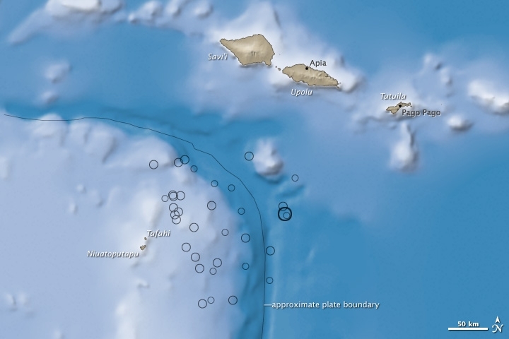
On the morning of September 29, 2009, a large undersea earthquake near Samoa generated a destructive tsunami. The tsunami killed nearly 200 people in Samoa, American Samoa, and Tonga, according to Reuters.
According to measurements from the United States Geological Survey (USGS), the magnitude 8.0 quake hit at 6:48 a.m. about 200 kilometers (125 miles) south of Apia, the capital of Samoa. The tsunami struck the islands of Savi’i, Upola, and Tutuila minutes later with waves that were 3.1 meters (10 feet) high near Pago Pago (American Samoa) and 1.4 meters (4.6 feet) in Apia, said the USGS. Smaller tsunamis hit other Pacific islands farther away from the quake’s epicenter.
This image shows the location of the earthquake in relation to the islands. The earthquake epicenter, shown by a large black circle, was located on the Pacific tectonic plate near its boundary with the Australian Plate (southwest corner of map). Dozens of magnitude 4 and 5 aftershocks, shown by open circles, followed the initial earthquake, continuing until at least September 30th.
The knee-shaped area of deep water is the Tonga Trench, a deep canyon on the edge of the Pacific Plate. The trench and associated faults are forming as the Pacific Plate moves westward, sinking beneath a complex series of smaller plates on the edge of the Australian Plate, the shallower area in the lower left corner of the image. The region around the Tonga Trench is one of the most active earthquake regions in the world, said the USGS.
Source: NASA image by Jesse Allen and Robert Simmon, using earthquake and plate tectonics data from the USGS Earthquake Hazard Program, elevation data from the Shuttle Radar Topography Mission (SRTM) courtesy of the University of Maryland’s Global Land Cover Facility, and ocean bathymetry data from the National Oceanic and Atmospheric Administration’s (NOAA) ETOPO1 global relief model of Earth’s surface. Caption by Robert Simmon.
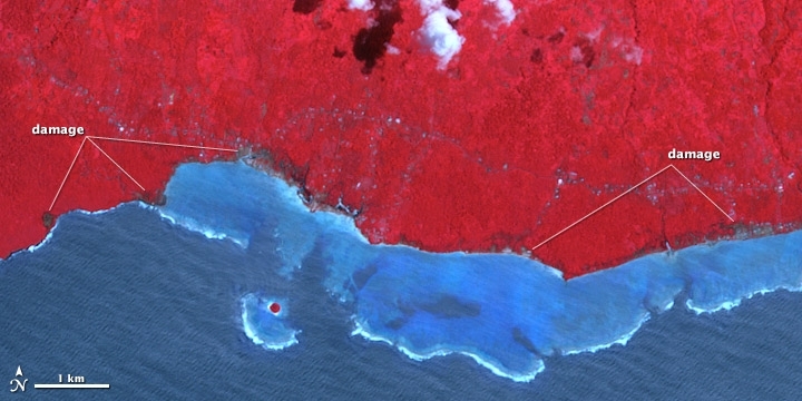
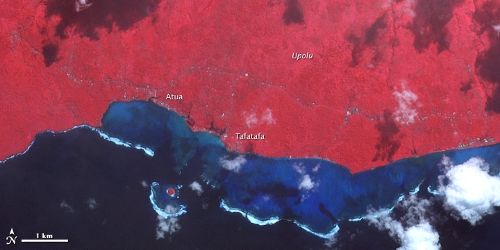
These false-color satellite images show damage to vegetation on Upolu’s coast. The top image shows the area after the tsunami, and the bottom image shows the same area five years earlier. Water is blue; buildings, clouds, and breaking waves are white; healthy vegetation is bright red, while damaged regions are dark gray. The most obvious differences between the two images occur in small patches along the coastline. The damaged area appears to extend up to 330 meters (1,100 feet) inland. Multiple buildings were severely damaged or destroyed in the village of Atua, and there was coastal erosion and road damage near Tafatafa, according to the U.N. Operational Satellite Applications Programme.
Source: NASA Earth Observatory image by Robert Simmon, using data from the NASA/GSFC/METI/ERSDAC/JAROS, and U.S./Japan ASTER Science Team. Caption by Robert Simmon
Resources
Natural Resources: hardwood forests, fish, hydropower
Land Use:
Economy
Samoans operate in a predominantly informal economy, with only 18% of the population formally employed in a salaried position. The figures given below reflect percentages of the formal economy, not necessarily the informal one, which represents more people but not much of the country’s wealth. The Samoan economy is dependent on tourism, capital flows from abroad (remittances, external borrowing, and aid) as well as some agricultural and manufacturing exports.
New Zealand is Samoa's principal trading partner, typically providing between 35% and 40% of imports and purchasing 45%-50% of exports. The growing number of Asian-owned businesses in Samoa has led to increasing trade with Hong Kong, China, and Japan. Australia, Fiji, and the United States, including American Samoa, also are important trading partners. Samoa's principal exports are coconut products, nonu fruit, and fish. Its main imports are food and beverages, consumer goods, industrial supplies, and fuels.
In the early 1990s, Samoa’s economy suffered blows from two consecutive cyclones (Cyclone Ofa in 1990 and Cyclone Valerie in 1991) and an outbreak of taro leaf blight (a root crop which is the staple food and was the largest export). The government responded to these shocks with a major program of road building and post-cyclone infrastructure repair. Economic reforms were stepped up, including the liberalization of exchange controls. GDP growth rebounded to over 6% in both 1995 and 1996 before slowing again at the end of the decade. From 2003 until the onset of the global economic downturn, Samoa enjoyed relative economic success with an average of 5.0% GDP growth yearly. The economic crisis, followed by the devastating September 29, 2009 tsunami, resulted in the contraction of the economy by 3.8% in 2008 and 1.7% in 2009. The economy saw encouraging signs of growth in 2010 with a 1.5% growth rate and a prediction of 2.8% for Samoan fiscal year 2011.
The service sector accounts for about three-quarters of GDP and employs approximately 50% of the formally employed labor force (which is about 18% of the population). Tourism is the largest single activity, more than doubling in visitor numbers and revenue over the last decade. In 2009, Samoa’s tourism industry encountered major obstacles, namely the global financial crisis and the devastation of the September 29 tsunami. The tsunami ravaged 25% of Upolu Island’s south and southeastern coast, which housed some prime resorts and beach “fales” (villas). This, however, did not undermine the booming industry, with tourism arrivals increasing to more than 128,000 in 2009 and contributing over $120.8 million to the local economy. The tourism industry started rebuilding a week after the devastation, making use of subsidies and concessional loan assistance from the Samoan, New Zealand, and Australian Governments. Some hotels have since opened and others are in the process of rebuilding.
Industry accounts for about 13% of GDP while employing less than 6% of the work force. The largest industrial venture is Yazaki Samoa, a Japanese-owned company processing automotive components for export to Australia under a concessional market-access arrangement. The parts are primarily used in production of Toyota vehicles. The Yazaki plant employed more than 2,000 workers, making up over 20% of the manufacturing sector's total output prior to 2008. The pressures of the global financial crisis led to job cuts of more than 50% for Yazaki, and while numbers went up again as the global economy grew, the devastation from the March 2011 Japanese earthquake and tsunami caused the numbers to once again decline to 800 employees. If the auto industry rebounds, and demand increases, it is presumed employment will return to previous levels.
The primary sector (agriculture, forestry, and fishing) employs less than 2% of the labor force and produces 3.6% of GDP. Important products include coconuts and fish.
The collapse of taro exports in 1994 has had the unintended effect of modestly diversifying Samoa's export products and markets. Prior to the taro leaf blight, Samoa's exports consisted of taro ($1.1 million), coconut cream ($540,000), and "other" ($350,000). Ninety percent of exports went to the Pacific region, and only 1% went to Europe. Forced to look for alternatives to taro, Samoa's exporters have dramatically increased the production of copra, coconut oil, and fish. These three products, which combined to produce export revenue of less than $100,000 in 1993, now account for over $6.7 million. There also has been a relative shift from Pacific markets to European ones, which now receive nearly 15% of Samoa's exports. These exports are still concentrated in fish ($5.8 million), nonu fruit products ($3.27 million), and coconut products ($0.9 million worth of copra, copra meal, coconut oil, and coconut cream), but are at least somewhat more diverse than before.
The more than 150,000 Samoans who live overseas provide two sources of important financial assistance from abroad. Their direct remittances have amounted to $128.2 million per year recently (about 24% of GDP), and they account for more than half of all tourist visits. In 2010 remittances dropped for the first time since 1998 after sustaining increases every year, a factor attributed to the increased unemployment rates in traditional source countries--the U.S. (including American Samoa), Australia, and New Zealand. In addition to the expatriate community, Samoa also receives more than $28 million annually in official bilateral development assistance from China, Japan, Australia, and New Zealand. These three sources of revenue--tourism, private transfers, and official transfers--allow Samoa to cover its persistently large trade deficit.
In March 2006, the United Nations reviewed Samoa's status as a Least Developed Country and recommended graduation into Developing Country status. Samoa sought a review of the decision on grounds of economic and environmental vulnerability, citing the 2009 tsunami and global financial crisis as grounds for extension. The UN agreed to extend Samoa’s transition period to January 2014.
In December 2011 Samoa officially joined the World Trade Organization (WTO) after 13 years of negotiations. Samoa has until June 15, 2012 to ratify the WTO accession package.
The Samoan Government has called for deregulation of the financial sector, encouragement of investment, and continued fiscal discipline, while at the same time protecting the environment. Observers point to the flexibility of the labor market as a basic strength for future economic advances.
Foreign reserves are in a relatively healthy state, the external debt is stable, and inflation is low.
GDP: (Purchasing Power Parity): $1.122 billion (2011 est.)
GDP: (Official Exchange Rate): $600 million (2011 est.)
GDP- per capita (PPP): $6,000 (2011 est.)
GDP- composition by sector:
agriculture: 11.7%
industry: 26.5%
services: 62% (2011 est.)
Agricultural products: coconuts, bananas, taro, yams, coffee, cocoa
Industries: food processing, building materials, auto parts
Currency: Tala (SAT)
