American Samoa

Contents
American Samoa
Published: December 4, 2011
Updated: September 27, 2012
Author: Central Intelligence Agency
Topic Editor: Peter Saundry
Source: CIA World Factbook; U.S. Department of Interior; National Park Service
Topics: Geography (main), Countries and Regions of the World Collection
American Samoa, a territory of the United States, is a group of five volcanic islands with rugged peaks and two coral atolls (Rose Island, Swains Island) in the South Pacific Ocean, about half way between Hawaii and New Zealand.
Approximately 60,000 of its 67,000 people live in Pago Pago,one of the best natural deepwater harbors in the South Pacific Ocean, sheltered by shape from rough seas and protected by peripheral mountains from high winds. American Somoa has a strategic location in the South Pacific Ocean

Its major environmental issues include limited natural freshwater resources; the water division of the government has spent substantial funds in the past few years to improve water catchments and pipelines.
Typhoons are common from December to March.
American Samoa experiences limited volcanic activity on the Ofu and Olosega Islands, neither has erupted since the 19th century
Settled as early as 1000 B.C., Samoa was "discovered" by European explorers in the 18th century. International rivalries in the latter half of the 19th century were settled by an 1899 treaty in which Germany and the US divided the Samoan archipelago. The US formally occupied its portion - a smaller group of eastern islands with the excellent harbor of Pago Pago - the following year.
American Samoa became a U.S. territory by deed of cession, starting in 1900. The matai (local chiefs) of Tutuila, the largest island in American Samoa, ceded the island to the United States in 1900. Manu’a followed in 1904. Swain Island joined the territory in 1925 by an act of the Congress. Authority over American Samoa was initially placed with the U.S. Navy which oversaw the territory until 1951.
Authority was transferred to the Department of the Interior (DOI) in 1956 where it resides. American Samoa is an unincorporated and unorganized territory of the US; administered by the Office of Insular Affairs, US Department of the Interior.
Unlike citizens of other U.S. territories who are U.S. citizens, American Samoans are U.S. nationals. However, neither citizens nor nationals of U.S. territories vote in Federal elections and pay Federal taxes. American Samoa came under Federal minimum wage rules in 2007 and controls its own immigration and border matters.
Geography
Location: Oceania, group of islands in the South Pacific Ocean, about half way between Hawaii and New Zealand
Geographic Coordinates: 14 20 S, 170 00 W
Area: 199 sq km
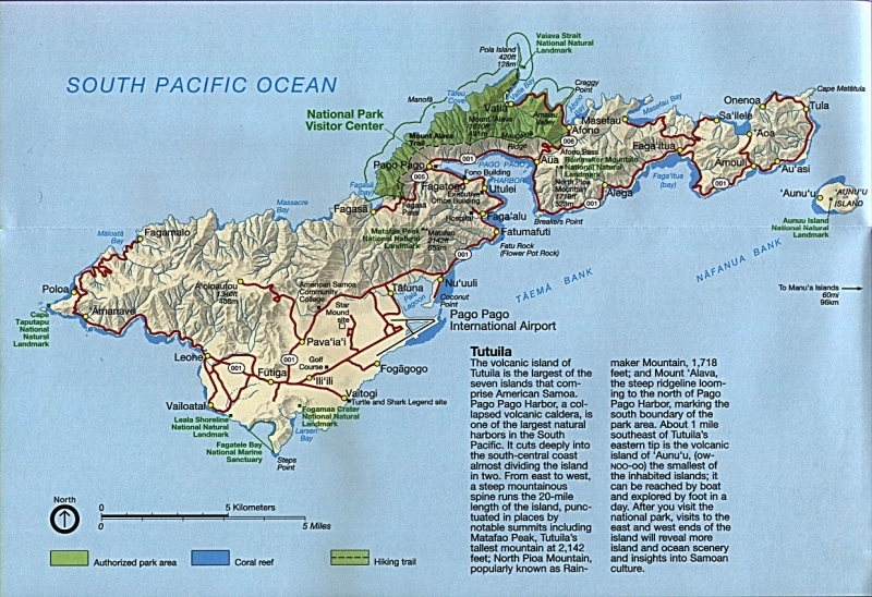
74% belonging to the island of Tutuila. Tutuila is roughly 30 km long and 6 km at its widest point with Pago Pago Harbor at the center of the island. This harbor is the remnants of a volcanic crater and a deep sheltered location, prime as an ocean vessel port. The majority of the population resides on this island. The NOAA ESRL/GMD Observatory lies at the northeast tip of the island, on Cape Matatula, just past the village of Tula. The drive from the airport to the observatory is roughly 24 miles, passing the major shopping areas, the port, the center of government, the open market, and numerous villages nestled along the main road, AS001.
Just off Tutuila is the island of Aunu’u. Small enough to walk around in roughly three hours and accessible by small boats from Auasi village. It is 4 km away from the observatory and visible in all but the worst of weather.
The Manu’a group is made up of three islands. The islands of Ofu and Olosenga, connected by a bridge, and Ta'u known for it’s shear rugged cliffs. These islands are east of the observatory and visible at roughly 90 km away on very clear days. Ofu has claim to a portion of the National Park of American Samoa. This section of park consists of a beautiful sand/shell hash beach and 140 hectares of offshore waters. The coral and reef fish number 300 species of identified fish and 150 species of coral found. Ta’u has claims to the highest point in American Samoa, Mt. Lata, the classic anthropological work “Coming of Age in Samoa” by Margaret Mead, as well as 2160 hectares of National Park lands and 400 hectares of waters separated by some of the tallest sea cliffs in the world.
Rose Atoll and privately owned Swain’s Island are the remaining two islands, both coral atolls.
Coastline: 116 km
Maritime Claims:
territorial sea: 12 nm
exclusive economic zone: 200 nm
Natural Hazards: Typhoons common from December to March. American Samoa experiences limited volcanic activity on the Ofu and Olosega Islands, neither has erupted since the 19th century.
Terrain: five volcanic islands with rugged peaks and limited coastal plains, two coral atolls (Rose Island, Swains Island) The highest point is Lata Mountain (964 meters.)
Climate: tropical marine, moderated by southeast trade winds; annual rainfall averages about 3 m; rainy season (November to April), dry season (May to October); little seasonal temperature variation
History & Political Status
Believed to be inhabited as early as 1000 B.C., the Samoans, along with Fiji and Tonga, are thought to be the original islands from which later Polynesian migrations sprung, colonizing a vast amount of the Pacific from the Hawaiian Islands to New Zealand. The Polynesians themselves may have originated in Southeast Asia as recently as 3,000 years ago. According to the traditions as told by their ancestors, the Samoan islanders had contact that was sometimes hostile with Fijians and other Pacific Islanders, as island kingdoms fought for supremacy. Before the arrival of European explorers, Tutuila was politically connected to ' Upolu Island.
In 1722, Dutch explorer Jacob Roggeveen became the first European to arrive in these islands, but for most of the 18th century European influence was limited to trading.
The Samoan islands, however, became competitive areas of interest between the United States, Germany, and the British Empire. By the Treaty of Berlin of 1899, the United Kingdom and Germany renounced in favor of the United States all their rights and claims over the eastern islands of Samoa, and the Samoan islands were divided between Germany (Western Samoa) and the United States (Eastern Samoa). This treaty went into effect on February 16, 1900. On April 17, 1900, the matai (chiefs) of Tutuila formally ceded the islands of Tutuila and Aunu'u to the United States. On July 16, 1904, the king and matai of Manu'a ceded the islands of Ta'u, Ofu, Olosega, and Rose Atoll to the United States. Congress formally ratified the 1900 and 1904 deeds of cession retroactively in 1929. Swains Island became part of American Samoa by joint resolution of Congress in 1925.
At the outbreak of the First World War in 1914, New Zealand occupied Western Samoa and administered the islands until 1962, when these islands were declared the Independent State of Samoa.
The U.S. Congress has not provided the territory with an organic act, which organizes the government much like a constitution would. Instead, the Congress gave plenary authority over the territory to the Secretary of the Interior, who in turn allowed American Samoans to draft their own constitution under which their government functions. American Samoa became self governing on July 1, 1967.
The American Samoa Constitution provides for an elected governor, lieutenant governor, and legislature. The governor and lieutenant governor are elected for four years. Up until 1951, the Governor of American Samoa was appointed by the U.S. Department of the Navy. In 1956, the Secretary of the Interior appointed the first native Samoan Governor, the Honorable Peter Tali Coleman. In 1977 American Samoa, for the first time, elected their own governor and lieutenant governor by popular vote.
The bicameral legislature of American Samoa, known as the Fono, is comprised of a Senate and House of Representatives. The Senate consists of 18 members who are chosen according to Samoan custom in each of the 14 political counties. Senators hold office for a four-year term, and representatives, for a two-year term. The House of Representatives consists of 20 members who are elected by popular vote. Swains Island has one non-voting member who is elected in an open meeting of the island residents. The legislature convenes for 45-day sessions twice yearly. The Chief Justice and the Associate Justices, who head the High Court of American Samoa, are appointed by the Secretary of the Interior from recommendations of the local Governor. The judiciary also consists of district and village courts. The judges for these courts are appointed by the Governor, subject to confirmation by the Senate. The United States civil and criminal cases, augmented by such local laws and regulations as enacted by Samoa legislature, constitute the body of law adjudicated in the courts. The current Chief Justice is Michael Kruse, the first native Samoan to be appointed to the position. Unlike other U.S. territories, American Samoa does not have a Federal district court. The Member of Congress from American Samoa (currently the Honorable Eni F.H. Faleomavaega), possesses in the standing Committees of the House, the same powers and privileges as Representatives from the several States, with the exception of voting on the House floor. The first delegate to the House of Representatives was Fofo I. F. Sunia, elected in November 1979.
Land Ownership
About 90 percent of the land is communally owned by aiga. The existing tenure law on communal lands prohibits alienation of any real property except freehold land to any person whose blood is less that one-half Samoan. Unless the Governor approves the transfer in writing, it is unlawful for any matai of a Samoan family to alienate any family lands to any person or lease it for any term more than 55 years. The American Samoan Government estimates that 1.5625 square miles of American Samoa's total area of 76.1 square miles are freehold land.
Ecology and Biodiversity
See: Samoan tropical moist forests
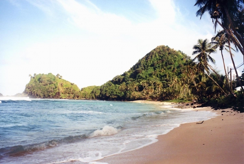
Deserted beach near Pago Pago. America Samoa is an incorporated, self-governing territory of the US. A part of the Samoan island chain, it is the southernmost territory of the US. The large harbor at Pago Pago contains a full US naval station. The inhabitants of America Samoa are American nationals, but not necessarily American citizens.
Government
Government Type: unincorporated and unorganized territory of the US; administered by the Office of Insular Affairs, US Department of the Interior
Capital: Pago Pago (capital) 60,000 (2009)
Legal System: mixed legal system of US common law and customary law
People and Society
Population: 67,242 (July 2011 est.)
Age Structure:
0-14 years: 31.9% (male 10,910/female 10,518)
15-64 years: 63.9% (male 21,764/female 21,228)
65 years and over: 4.2% (male 1,322/female 1,500) (2011 est.)
Population Growth Rate: 1.211% (2011 est.)
Birthrate: 22.84 births/1,000 population (2011 est.)
Death Rate: 4.1 deaths/1,000 population (July 2011 est.)
Net Migration Rate: -6.63 migrant(s)/1,000 population (2011 est.)
Life Expectancy at Birth: 74.21 years
Total Fertility Rate: 3.16 children born/woman (2011 est.)
Languages: Samoan 90.6% (closely related to Hawaiian and other Polynesian languages), English 2.9%, Tongan 2.4%, other Pacific islander 2.1%, other 2%. Note: most people are bilingual (2000 census)
Literacy (age 15 and over can read and write): 97%
Urbanization: 93% of total population (2010) growthing at an annual rate of change of 1.8% (2010-15 est.)
Agriculture
Agricultural products: bananas, coconuts, vegetables, taro, breadfruit, yams, copra, pineapples, papayas; dairy products, livestock
Resources
Natural Resources: pumice, pumicite
Land Use:
arable land: 10%
permanent crops: 15%
other: 75% (2005)
Economy
American Samoa has a traditional Polynesian economy in which more than 90% of the land is communally owned. Economic activity is strongly linked to the US with which American Samoa conducts most of its commerce. Tuna fishing and tuna processing plants are the backbone of the private sector, with canned tuna the primary export. The two tuna canneries account for 80% of employment. In late September 2009, an earthquake and the resulting tsunami devastated American Samoa and nearby Samoa, disrupting transportation and power generation, and resulting in about 200 deaths.
The US Federal Emergency Management Agency is overseeing a relief program of nearly $25 million. Transfers from the US Government add substantially to American Samoa's economic well being. Attempts by the government to develop a larger and broader economy are restrained by Samoa's remote location, its limited transportation, and its devastating hurricanes.
Tourism is a promising developing sector.
GDP: (Purchasing Power Parity): $575.3 million (2007 est.)
GDP: (Official Exchange Rate): $462.2 million (2005)
GDP- per capita (PPP): $8,000 (2007 est.)
Industries: tuna canneries (largely supplied by foreign fishing vessels), handicrafts
Currency: U.S. Dollar.
Coastline of American Samoa: Source: NOAA.