Saint Helena (British Overseas Territory)
| Topics: |
Source: NASA
Countries and Regions of the World Collection 
The islands that form this territory are located in the South Atlantic Ocean, about midway between South America and Africa.Ascension Island lies 700 nm northwest of Saint Helena; Tristan da Cunha lies 2,300 nm southwest of Saint Helena.
The islands of this group result from volcanic activity associated with the Atlantic Mid-Ocean Ridge.
|
|
|
|


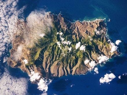
Saint Helena harbors at least 40 species of plants unknown elsewhere in the world. as seen in the above photograph from the International Space Station, Saint Helena's rugged topography of sharp peaks and deep ravines is the result of erosion of the volcanic rocks that make up the island. A climatic gradient related to elevation is also evident - the higher, wetter central portion of the island is covered with green vegetation, whereas the lower coastal areas are drier and hotter with little vegetation cover.
Ascension is a breeding ground for sea turtles and sooty terns.
Queen Mary's Peak on Tristan da Cunha is the highest island mountain in the South Atlantic and a prominent landmark on the sea lanes around southern Africa.
Contents
Saint Helena
About 14 million years old, St. Helena is the deeply eroded summit of a composite volcano. The resulting topography is quite dramatic. Plugs, domes, and dykes from the volcanoes create striking formations with names such as Lot, Lot's Wife, and the Gates of Chaos.
It was uninhabited when first discovered by the Portuguese João da Nova discovered the island on May 21, 1502; now feast day for St. Helena in the Eastern Church.
It was visited again in 1588 by Captain Thomas Cavendish aboard the HMS Desire and soon became a port of call for ships en route between the East Indies and Europe.
St. Helena’s first inhabitants were employees of the trading companies and English settlers, who also brought slaves from South Asia, the East Indies, and Madagascar. By 1673 nearly half of the island’s inhabitants were slaves, until emancipation was achieved between 1826 and 1836.
St. Helena became famous when Napoleon was exiled to the island in 1815; he died there in 1821.
During the Zulu wars, the island was used again as a place of exile for Zulu warriors. During the Anglo-Boer War in South Africa, several thousand Boer prisoners were confined on the island between 1900 and 1903.
Its importance as a port of call declined after the opening of the Suez Canal in 1869.
St. Helena is a British colony, with its capital and port at Jamestown.
Ecologically, it is included within the St. Helena scrub and woodlands ecoregion.
It is believed that St. Helena once had substantial forests at elevations ranging between 400 and 600 m, primarily composed of gumwood (Commidendrum robustum) with smaller amounts of bastard gumwood (Commidendrum rotundifolium). Introduced goats between the island’s discovery in 1502 and settlement in 1659 fragmented these forests, though large wooded areas still persisted. Remaining forest was then virtually eradicated during the 18th century through extensive cutting for firewood and the grazing of stock animals. A small gumwood stand survives at Peak Dale; the remainder of the island is covered by pasture, abandoned flax plantations, replanted woodland, dry rocky lowland, and some semi-natural shrubland vegetation.
Due to St. Helena’s isolation, the island was a refuge for many endemic species. It is believed that many of the island’s native plants are relicts of a primitive flora that was once widespread and that colonized the island as many as 10 million years ago. An example is seen in the tree fern (Dicksonia arborescens), which has been on St. Helena for at least 9 million years but no longer occurs in its likely source area of Africa. This type of relict endemic is frequent on islands, and is an important remnant of biodiversity that has disappeared elsewhere.
The island’s native flora was composed of about 70 species of flowering plants and ferns, 60 of which are endemic in 10 endemic genera. These numbers place St. Helena in the top ranks of islands important for unique worldwide biodiversity. However, St. Helena has suffered severe degradation, and over half of the plants described in 1875 have since disappeared from the island. Currently, the remaining endemic plants are restricted to small remnants of their former habitat in protected spots such as steep cliffs or wastelands.
Quite a few species once thought to be extinct have been rediscovered in recent times, including the local ebony (Trochetiopsis ebenus), St. Helena olive (Nesiota elliptica), false gumwood (Commidendrum spurium) and bastard gumwood (Commidendrum rotundifolium). While native vegetation declined many economically important plants were being introduced, and the total number of plant species present on St. Helena increased significantly. The flora now claims about 320 species, of which approximately 260 are naturalized aliens (Exotic species).
Diana's Peak is a National Park, and wardens work to preserve endemic species such as tree [[fern]s] and dogwoods that have been inundated by introduced plants such as the New Zealand flax.
A severe drought occurred in 1984. Water is a scarce resource on St. Helena for humans and nature alike, and drought poses a significant threat to the fragile and isolated ecosystem.
The island is far from being economically self-sufficient and depends largely on funding from the United Kingdom. There has been a push to promote tourism as a source of revenue, though the island has never been accessible by airplane due to its mountainous terrain.
Currently, A British company, the St. Helena Leisure Corporation (SHELCO) has made proposals "to develop communications and tourist amenities on the island by constructing a privately-funded airport, a world-class international quality resort hotel, and a superior 18-hole championship-standard golf course." It appears that the project has strong support from the local community. The proposed airstrip would be leveled near a spot called Prosperous Bay Plain, a 150 hectares (ha) area of semi-desert supporting the native shrub, Suaedia fruticosa, and an endemic annual, Hydrodea cryptantha as well as many endemic invertebrates, some of which are known exclusively from this plain. While Prosperous Bay Plain is also thought to be closer to the endemic wirebird’s original habitat than any other now existing on the island, the bird occurs here in much lower numbers than it does in non-native pasturelands. While not yet accepted, the construction of an airstrip would have many impacts beyond the rock-blasting and cut-and-fill alteration of the Prosperous Bay Plain area.
Geographic Coordinates: 15 57 S, 5 42 W
Area: 122 sq km
Coastline: 60 km
Maritime Claims:
Terrain: rugged, volcanic; small scattered plateaus and plains. The highest point is Mount Actaeon (818 m).
Climate: tropical marine; mild, tempered by trade winds
Ascension Island
Ascension is a relatively young volcanic island with 44 distinct craters, all considered "dormant" rather than extinct. The last major volcanic eruption occurred approximately 600 years ago. Much of the island remains covered by basalt lava fields and cinder cones, and steep cliffs mark the south and southeast coasts. There is a sloping plain to the northwest and sandy beaches.
This barren and uninhabited island was discovered and named by the Portuguese. It discovered in 1501 by Joao da Nova Castelia, and was then visited two years later on Ascension Day by Alphonse d'Albuquerque, who named the island.
The dry, barren nature of Ascension made it of little use to the East Indies fleets, and it remained uninhabited until Napoleon was incarcerated on St. Helena in 1815 and a small British naval garrison was established to prevent a rescue of Napoleon from Saint Helena.
The island served use as a resting stop for ships engaged in the suppression of the slave trade around the West African coast during this period. Ascension was managed by the Royal Marines from 1823 until it was made a Dependency of St. Helena in 1922, and was then managed by the Eastern Telegraph Company, later named Cable and Wireless.
During World War II, the UK permitted the US to construct an airfield on Ascension in support of trans-Atlantic flights to Africa and anti-submarine operations in the South Atlantic.
In 1964, radio broadcast stations were established to facilitate transmissions to southern Africa, and an Administrator was appointed. In the 1960s the island also became an important space tracking station for the US.
In 1982, Ascension was an essential staging area for British forces during the Falklands War.
It remains a critical refueling point in the air-bridge from the UK to the South Atlantic.
Ecologically, it is within the Ascension scrub and grasslands ecoregion.
At least 311 species of land animals (a few of which are now extinct) have established themselves on Ascension Island, while only about 95 species are considered to be native. This includes two marine turtles, twelve seabirds, and two extinct landbirds. Natural colonists arrive primarily by air, though some apparently crossed the ocean attached to birds or other animals or on floating objects. The natural colonization of Ascension Island was almost entirely from Africa.
Geographic Coordinates:7 57 S, 14 22 W
Area: 88 sq km
Maritime Claims:
Terrain: surface covered by lava flows and cinder cones of 44 dormant volcanoes; ground rises to the east. The highest point is Green Mountain (859 m).
Climate: tropical marine; mild, semi-arid
Tristan da Cunha
The Tristan da Cunha Island Group (37° 06' S, 12° 18' W) is an archipelago of five volcanic islands resting on the east slope of the mid-Atlantic ridge, midway between Africa and South America. Tristan Island is the youngest island in the group, at one million years, and is still considered volcanically active with its most recent eruption occurring in 1961-62. The island is 41 km2 and has a volcanic cone that reaches 2,062 meters (m) with a base circumference of 34 km. The volcano is often snow-capped and has a crater lake. The coast is characterized by sea cliffs of up to 600 m in height, occasionally broken by low coastal strips. Above the cliffs, a 600-900 m plateau of sorts surrounds the base of the volcano. The island’s small settlement, called Edinburgh, is on the northwest coast. Other islands in the group, Nightingale Island and Inaccessible Island, are eroded volcanic cones once similar in size to Tristan Island. Two small islands near Nightingale are named Stoltenhoff Island and Center, or Middle, Island.
Often referred to as the "Remotest Island in the World", Tristan Island has an unusual human history. The island group was discovered by Portuguese Admiral Tristado d'Ancunha in 1506, and was visited by sealers and whalers during the 18th century. The British formally annexed the islands, and a small community was founded in the early 1800’s. It was garrisoned by the British in 1816 to prevent any attempt to rescue Napoleon from Saint Helena.
The island’s population had reached almost 300 in 1961, when a [[volcanic] eruption] forced the islanders to evacuate. After a period in England, the majority of the islanders chose to return to Tristan in 1963. The island’s current population has a remarkable continuity with its founding members. Tristan Islanders speak a distinct dialect of English that reflects their origins in Georgian England but is also laced with a few early Americanisms.
Gough Island (40°21'S, 09°53'W) lies approximately 425 km southeast of Tristan da Cunha, consisting of one main island and several offshore islets and rocks. Most of these are within 100 m of the main island, and the largest support vascular plants and breeding birds. Volcanic in origin, the Gough Island group covers 65 km² and has a high point of 910 m, at Edinburgh Peak. The islands’ most recent volcanic activity occurred about 2,400 years ago; Gough was part of the same volcanic mass as the Tristan formations. Gough Island is composed of a central plateau with several mountain peaks, and the [[coast]line] is marked by cliffs of 300 m to 450 m in height with narrow boulder beaches and no sheltered harbor; the only area below 200 meters (m) altitude is at the southern end of the island.
Tristan Island, being the only permanently inhabited island in this group, has experienced the greatest degree of environmental degradation. Pressures have resulted from agriculture, overgrazing by sheep, tree removal, fire, and the introduction of exotic species. The exploitation of natural resources on Tristan was critical for human survival until the middle of this century, and some native species were almost or completely exterminated. The small community on the island has since taken several locally based measures to reverse this trend. The Island Council passed the first Protection Ordinance in 1950, and in 1994, Inaccessible Island was declared a nature reserve. This island is globally important for its endemic terrestrial species, including the flightless rail, as well as being a breeding site for many seabird species. The islanders retain the right to collect driftwood and guano from the uninhabited island.
Gough Island was exploited by sealers in the late 18th and early 19th centuries, with sealers camping on the island for considerable periods of time. They existed on seabirds and their eggs, fish, wild plants, and cultivated potatoes, which are no longer present on the island. Whaling occurred in the waters of Gough Island between 1830 and 1870, though the island remained uninhabited.
The island has been visited by scientists periodically since 1811, and meteorologists have inhabited the island since 1956. South Africa leases a site for a meteorological station on Gough Island. The meteorological station, with its associated facilities and helicopter landing site, is the only man made structure on the island.
In 1995, Gough Island and its territorial waters to three nautical miles were inscribed on the World Heritage List, only the third natural British site to be included. Justification for the listing included the fact that Gough is the largest scarcely modified cool temperate island ecosystem in the South Atlantic Ocean; for its huge fur seal and rockhopper penguin populations, endemic landbirds, plants and invertebrates; and its importance as a seabird colony.
Gough and Inaccessible Islands have been designated World Heritage Sites.
Ecologically, the islands are included within the Tristan Da Cunha-Gough Islands shrub and grasslands ecoregion.
Gough Island is one of the most important seabird colonies in the world. About 20 species of seabirds breed on the island. The Tristan Island group supports many of the same bird species as well as claiming a few unique populations. BirdLife International has classified both Tristan da Cunha and Gough as important Endemic Bird Areas. Land birds on Gough Island have been protected under the Tristan da Cunha Wildlife Protection Ordinance since 1950; the Tristan da Cunha Conservation Ordinance of 1976 then declared the island and its waters a wildlife reserve.
Only two native breeding mammals occur on the Tristan-Gough Islands. Subantarctic fur seal (Arctocephalus tropicalis) are abundant, and southern elephant seal populations (Mirounga leonina) have been increasing. Populations of these as well as local marine mammals, southern right whale (Eubalaena glacialis australis) (EN) and dusky dolphin (Lagenorhynchus obscurus), have fluctuated greatly in recent history due to hunting.
Geographic Coordinates: 37 15 S, 12 30 W
Area: 98 sq km
Coastline: 40 km
Maritime Claims:
Natural Hazards: Active volcanism. The island volcanoes of Tristan da Cunha (elev. 2,060 m) and Nightingale Island (elev. 365 m) experience volcanic activity; Tristan da Cunha erupted in 1962 and Nightingale in 2004.
Terrain: sheer cliffs line the coastline of the nearly circular island; the flanks of the central volcanic peak are deeply dissected; narrow coastal plain lies between The Peak and the coastal cliffs. The highest point is Queen Mary's Peak (2,060 m).
Climate: temperate marine; mild, tempered by trade winds (tends to be cooler than Saint Helena)
Government
Dependency status: overseas territory of the UK
Capital: Jamestown - 1,000 (2009)
Administrative divisions: 3 administrative areas; Ascension, Saint Helena, Tristan da Cunha
Legal System: English common law and local statutes
People and Society
Population: 7,700 (July 2011 est.). Nnly Saint Helena, Ascension, and Tristan da Cunha islands are inhabited.
Ethnic Groups: African descent 50%, white 25%, Chinese 25%
Age Structure:
0-14 years: 17.8% (male 697/female 671)15-64 years: 70% (male 2,731/female 2,656)65 years and over: 12.3% (male 468/female 477) (2011 est.)
Population Growth Rate: 0.377% (2011 est.)
Birthrate: 10.65 births/1,000 population (2011 est.)
Death Rate: 6.88 deaths/1,000 population (July 2011 est.)
Net Migration Rate: 0 migrant(s)/1,000 population (2011 est.)
Life Expectancy at Birth: 78.76 years
Total Fertility Rate: 1.57 children born/woman (2011 est.)
Languages: English
Literacy (age 20 and over can read and write): 98% (1987 est.)
Urbanization: 40% of total population (2010) declining at an annual rate of change of 0.3% (2010-15 est.)
Resources
Natural Resources: fish, lobster
Land Use:
Economy
The economy depends largely on financial assistance from the UK, which amounted to about $27 million in FY06/07 or more than twice the level of annual budgetary revenues.
The local population earns income from fishing, raising livestock, and sales of handicrafts.
Because there are few jobs, 25% of the work force has left to seek employment on Ascension Island, on the Falklands, and in the UK.
GDP: (Purchasing Power Parity): $18 million (1998 est.)
GDP- per capita (PPP): $2,500 (1998 est.)
Agricultural products: coffee, corn, potatoes, vegetables; timber; fish, lobster; livestock
Industries: construction, crafts (furniture, lacework, fancy woodwork), fishing, philatelic sales
Currency: Saint Helenian pounds (SHP)