Ross Ice Shelf
Source: NOAA
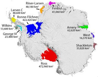 Antarctica's major ice shelf areas. The Ross Ice Shelf is shown in red. Source: National Snow and Ice Data Center
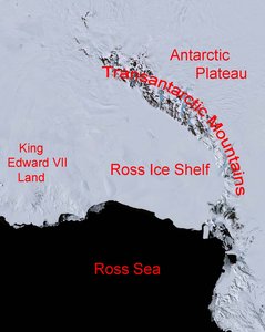
 The Ross Ice Shelf is the largest ice shelf in the world with an area of roughly 182,000 square miles (472,000km²), and is about the size of Spain. This ice topographic landform is one of the 47 named Antarctic Ice Shelves. It is bordered by the Ross Sea to the north, the Transantarctic Mountains to the west and south, and by the King Edward the VII Peninsula to the east.
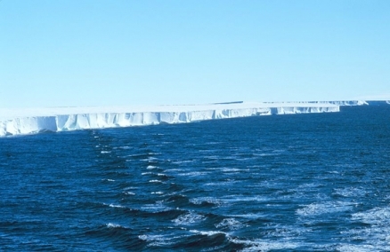
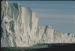
Facing and overlying much of the coastal zone of the Ross Sea, it presents a nearly vertical icecliff of between 50 and 200 feet (15 and 60 meters) above the water surface and500 miles(800 kilometers) long between Ross Island and the King Edward the VII Peninsula. The interior of the Shelfentends from 400 to nearly 600 miles.
Most of the Ross Ice Shelf is located within the Ross Dependency claimed by New Zealand. However, the claim is not recognized by most countries or under the Antarctic Treaty System.
The ice shelf was named after Captain James Clark Ross who discovered it on 28 January 1841. It was originally named the "Great Ice Barrier" orthe"Ice Barrier"or the "Barrier."Ross mapped the ice front eastward to 160°W.
Exploration
See main article: Exploration of the Antarctic
 Satellite Image of Ross Ice Shelf. Source: Landsat Image Mosaic of Antarctica
 InJanuary 1841, a British expedition under the command of James Clark Ross, composed of thetwo sailing shipspassed through the pack ice of the Pacific near Antarctica for the first time, in an attempt to reach the South Magnetic Pole. After four days moving through the pack ice, they found their way into open water (later named the Ross Sea) and continued southalong theeast coast of Victoria Land,until the reached an island(named Ross Island) with two main volcanoes (named Mount Erebus andMount Terror. The ice-boundRoss Island fronted a vast wall of icewhich stretched off to the east facing the sea.Over thefollowing days, Clark's ships sailed west for 300 miles under the face of the ice cliff untilthey reached cove in the ice where they marked their Farthest South point, before turning back. A year later Clarke returned and extended the charting of the "Great Ice Barrier" farther west.
Because the Ross Ice Shelf is the closest part of Antarctica to the South Pole reachable by ship, it became the starting point forexplorers seeking to reach that point. Robert Falcon Scott's Discovery Expedition (1901-4) and Terra Nova Expedition (1910-13), and Ernest Shackleton's Nimrod Expedition (1907-9) based themselves on Ross Island and made a significant study of the nearby parts of the shelf and along their routes toward the South Pole.
Sailing east along the front of the Ross Ice Shelf in 1907, Shackleton discover a cove which he named the Bay of Whales and which may have been the same cove seen by Clark. The Bay of Whales was used was a base byRoald Amundsen in his South Pole expedition (See The South Pole: An Account of the Norwegian Antarctic Expedition in the "Fram"; 1910–1912.)
Amundsen, Shackleton andScott all crossed the shelf to efforts toreach the Pole. (See Amundsen and Scott at the South Pole).
Richard Byrd led five Antarctic expeditions (1928-30, 1933–35, 1939–40, 1946–47 and 1955–56), which were includedbases at the Bay of Whales and which conducted extensive flights that photographed and mapped much of the Ross Ice shelf for the first time.
Extent, Composition and Movement
 Ross Ice Shelf.
 The Ross Ice Shelf extends in longitude from approximately 155°Wto 160°E, and in latitude from approximately 78°S and 86°S.
The front of the Ross Ice Shelf has an average thickness of 1100 feet (330 meters), orwhich the top 100-200 feet (30-60 meters) presents itself as a cliff above the water line. The southern interior of the shelf becomes steadily thicker, reaching 2300 feet (700 meters) in thickness.
The Ross Ice Shelf isa glacier-fed ice shelf.Eight glaciers flow down from the West Antarctic Ice Sheet (Antarctic Plateau) through the Transantarctic Mountains feed into the Shelf and gradually add bulk to it. At the same time, the freezing of seawater below the ice mass increases the thickness of the ice from 40 cm (16 in) to 50 cm (20 in).
Periodically,fissures and cracks form in theice shelf behind its front to the Ross Sea and large slabs of the shelfbreak off or "calve" to create tablular icebergs that float away into the Ross Sea. In March 2000, the world's largest recorded iceberg (Iceberg B-15), was calved from the Ross Ice Shelf. It was about 12,000 square miles (31,000 km²), that is slightly larger than the size of the country Belgium or the U.S. state Massachusetts.
Scientists have long been intrigued by the shelf and its composition and made numerous temporary research stationson or adjacent to the Ross Ice Shelf. Tow permanent research stations exist on Ross Island adjacent to the shelf, theU.S. McMurdo Station and the New Zealand Scott Station. Many scientific studies of the shelf were initiated during the International Geophysical Year (1957-8).
From 1967 to 1972 the Scott Polar Research Institute reported extensive observations using radio echo sounding. The technique allowed measurements to be taken from the air; allowing a criss-cross track of 35,000 km to be covered; compared with a 3000 km track from previous seismic sounding on the ground. More detailed surveys were executed between 1973 and 1978.
The Ross Ice Shelf Project(1974-79) drilled ahole through the Shelf to "examine the ice thickness, the ice shelf bottom, the bottom of the sub glacier sea, the water below the ice shelf, the biota, and the sediments below the ice. The scientific objectives of RISP were to investigate the physical, chemical, biological, and geological conditions in the ice shelf, in the water mass beneath the ice, and in the soft sediments and bedrock at the ocean floor, and to use the data obtained in the interpretation of the present conditions and past history of this portion of Antarctic."
In the 1980s, a network of weather stations were installed to record temperatures on the shelf as well as throughout the more remote reaches of the continent.
See Also
Further Reading
- Images of the Ross Ice Shelf
- Scott Polar Reseatch Institute, University of Cambridge
- Ross Ice Shelf Project; "The Ross Ice Shelf Project," Clough, John W. and B. Lyle Hansen, Science, Vol. 203, No. 4379, Feb. 2, 1979, pp. 433-455;RISP Technical Reports are available from from the ROSS Ice Shelf Project Management Office, University of Nebraska, Lincoln, NE
- National Snow and Ice Data Center], University of Colorado
Note: This article uses some material from the Wikipedia article Ross Ice Shelf that was accessed on February 23, 2009. The Author(s) and Topic Editor(s) associated with this article have significantly modified the content derived from Wikipedia with original content or with content drawn from other sources. All content from Wikipedia has been reviewed and approved by those Author(s) and Topic Editor(s), and is subject to the same peer review process as other content in the EoE. The current version of the Wikipedia article differs from the version that existed on the date of access. This article is licensed under the GNU Free Documentation License 1.2. See the EoE’s Wikipedia Policy for more information.