Pyrenees-Mont Perdu, France and Spain
Pyrenees-Mont Perdu (42°38'N, 0°10'W) is a World Heritage Site situated in the central Pyrenees mountain range on the international boundary between France and Spain.
Contents
- 1 Geographical Location
- 2 Date and History of Establishment
- 3 Area
- 4 Land Tenure
- 5 Altitude
- 6 Physical Features
- 7 Climate
- 8 Vegetation
- 9 Fauna
- 10 Cultural Heritage
- 11 Local Human Population
- 12 Visitors and Visitor Facilities
- 13 Scientific Research and Facilities
- 14 Conservation Value
- 15 Conservation Management
- 16 IUCN Management Category II
- 17 Further Reading
Geographical Location
Situated in the Central Pyrénées mountain range on the international boundary between France and Spain. 42°38'N, 0°10'W. In France, to the North, it is located in the Hautes-Pyrénées Department in the Midi-Pyrénées Region. The southern part of it, in Spain, includes the municipalities of Torla, Fanlo, Tella-Sin, Puértolas, Bielsa y Broto in the Huesca Province of the Autonomous Community of Aragón
Date and History of Establishment
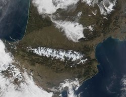 Pyrenees Mountain Range. (Source: NASA Visible Earth)
 - The nominated site includes two bordering national parks: the entire Ordesa y Monte Perdido National Park in Spain and the eastern part of Pyrénées Occidentales National Park in France.
- These were established by Spanish Royal Decree of 1918 (extended from 2,100 hectares (ha) to 15,608 in 1982) and by the French Governmental Decree on 1967, respectively.
- The Spanish National Park received the Council of Europe European Diploma category A in 1,988, which was renewed in 1993, it has also been established as a Special Protection Area under the 1979 Birds Directive. It includes the core area (8,116 ha) of the Ordesa-Viñamala Reserve (51,396 ha), which was internationally recognised as a Biosphere Reserve in 1977.
- Viñamala National Hunting Reserve was established in 1966 and it is coincidental with Ordesa-Viñamala Biosphere Reserve.
- In France the Gavarnie, Troumouse and Estaubé "Site Classé" (Classified Reserve) was established in 1941.
- There is a buffer zone surrounding the nominated site which includes to the north the remaining area of the Gavarnie,
- Troumouse and Estaubé "Sitre Classé" (France) and in Spain: to the west the remaining area of the Viñamala National Hunting Reserve, coincidental with Ordesa-Viñamala Biosphere Reserve; to the south two buffer zones of the Spanish national park; and to the east another buffer zone and the Los Circos National Hunting Reserve established in 1966.
- A Cooperation Charter between France and Spain was signed in September 1988.
- Inscribed on the World Heritage List in 1997 and modified in 1999.
Area
The site covers an area of 31,189 hectares (ha), of which 20,134 ha are in Spain: the entire "Ordesa y Monte Perdido" National Park (15,608 ha), and a buffer zone of 4,526 ha; and 11,055 ha in France: the eastern part of Pyrénées Occidentales National Park (7,451 ha) and part of Gavarnie "Site Classé" (3,559 ha).
Land Tenure
In France mainly owned by the communities of the Barèges and Aure valleys and in Spain mainly by the municipal governments of the five localities included. There are also some State and private ownership.
Altitude
From 600 metres (m) to 3352 m (Monte Perdido/Mont Perdu).
Physical Features
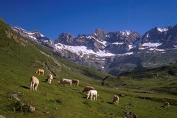
The site, a limestone massif, is a mountain landscape with lakes, waterfalls, rocky outcrops, glacial cirques and canyons. The four glacial cirques: Gavarnie, Estaubé, Troumouse and Baroude are located to the north; to the south there are three canyons and a gorge: Ordesa, Añisclo, Pineta and Escuaín. Three distinct geomorphological regions are found. First, in the north, three convergent valleys are surmounted by crests oriented north-south comprising schistose and sandstone. The cirques of Estaubé and Troumouse are separated in the south-east by a crest dominated by Munia Peak (3133 m). The second region comprises a line of steep limestone steps stretching for 20 kilometers (km), most of the summits of which are higher than 3000 m). Third, high sandstone and schistose plateaus, at about 2,000 m are found to the southwest of the "Tres Serols".
Climate
Altitude and topography significantly affect the local climate. The two main climate regimes are oceanic climate to the north and a continental peri-Mediterranean climate to the south side. Average annual temperature is 5°C, mean winter temperature in February is -1°C and the mean during the summer (July) is 12°C. Rainfall varies from 900 millimeters (mm) to 2,000 mm, annual mean rainfall is 1,600 mm. Seasonal distribution of rainfall is approximately winter (16%), spring (30%), summer (22%), and autumn (32%).
Vegetation
Five vegetation types have been described: submediterranean, collinean, montane, subalpine and the alpine type. The submediterranean type is mostly found in valleys in the south and is dominated by Quercus ilex rotundifolia in rocky sites, and Quercus faginea in deep soils. The collinean vegetation is dominated by Quercus sessiliflora The montane areas are characterized by beech Fagus sylvatica, Abies alba and Pinus sylvestris. Ramonda myconi, endemic to the Pyrénées,is found in this habitat and others species such as the Pyrenean saxifrage Saxifraga longifolia, Antirrhinum sempervirens and Pinguicula longifolia occur in the same habitat. The subalpine vegetation is dominated by black mountain pine Pinus uncinata, Vicia argentea (R) and the endemic Borderea pyrenaica. The alpine area holds a high proportion of endemic species to the Pyrénées, including Saxifraga iratiana and Androsace pyrenaica. The flora includes more than 1500 species, of which 50 are Pyrenean endemic species.
Fauna
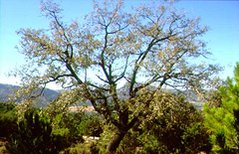 Quercus fanginea. (Source: Princeton University, Department of Ecology and Evolutionary Biology)
 The site supports many species typical of the Pyrénées. Mammals include the marmot Marmota marmota, Mustela erminea, ungulates such as Capreolus capreolus and Rupicapra p. pyrenaica, with the population estimated at 800 individuals, and Spanish ibex Capra p. pyrenaica now only three female individuals. A small brown bear Ursus arctos population remains in the Pyrenees, but not in the nominated area. The insectivorous Pyrenean desman Galemys pyrenaicus, occurs in lowland elevation. The avifauna includes Lammergeyer Gypaetus barbatus, in decline throughout Europe, Bonelli's Eagle Hieraëtus fasciatus, Lagopus mutus, Tetrastes bonasia, Tetrao urogallus, Pyrrhocorax graculus, Parus palustris, Certhia familiaris, Tichodroma muraria, Oenanthe oenanthe, Phoenicurus ochrurus, Prunella collaris, Anthus s. spinoletta, and Montifringilla nivalis. Reptiles include the montane lizard Archaeolacerta bonnali, restricted to high elevations. Among the amphibians, species of interest include Euproctus asper, Rana temporaria and R. pyrenaica. Other noteworthy fauna include cave-dwelling species such as a collembolan Tricanthella frigida, an endemic found in Gavarnie cirque at 2500 m, and coleopteran Tipnus unicolor and Speonomus bolivari.
Cultural Heritage
There are human settlements in the area since the Palaeolithic (40,000-10,000 BC). The Massif has played a major role in the communication between Spanish and French communities bordering the site. Cultural similarities are found in both sides of the nominated area, especially the use of terraces. Striking terraces and cultural monuments constitute a significant symbol of past occupation in the region.
Local Human Population
Socio-economic activities have declined during last 50 years, although transhumant grazing still occur, with livestock being grazed on the massif in summer. The only two economic activities occurring the nominated site are related to grazing and trekking.
Visitors and Visitor Facilities
A total of two million tourists visit the site each year. Two places are most visited, Torla in Spain, and Gavarnie village in France. The Cirque de Gavarnie is a glacial amphitheatre with a rock-face popular with climbers, and with one of the highest waterfalls (423 m) in the Pyrénées. Measures have been taken to limit visitor pressure, especially those using cars, in order to encourage pedestrians to visit the protected areas. In general, entrance to the site is controlled by national park managers. Four mountain refuges are available between 2,000 and 2,600 m altitude: Góriz in Spain; La Brèche- Boucharo, Les Espuguettes and Barroude in France. Other accommodation is available in villages and two hotels outside the site.
Scientific Research and Facilities
According to the Cooperation Charter, two species are considered of particular research interest: Rupicapra p. pyrenaica, and Capra p. pyrenaica. No further information is available.
Conservation Value
The site represents a exceptional geophysical landscape. Around 20 km of Pyrenean mountains cross the site from west and north-west to east and southeast. The massif play a hydrographical role as a watershed, and contains important and spectacular cirques. The site has served as a refuge during glacial periods, leading to a high degree of endemism in fauna and flora. Many species are restricted to Monte Perdido such as Saxifraga iratiana and Androsace pyrenaica, Rupicapra p. pyrenaica, Capra p. pyrenaica, and Rana pyrenaica.
Conservation Management
The conservation plan is oriented towards limiting road construction and vehicle use. Farming is recognized as an integrated activity for local communities. Other programs include the management of the large numbers of visitors to the site.
Management plans: Spain: Plan Rector de Uso y Gestión del Parque Nacional de Ordesa y Monte Perdido, approved in 1995 by Royal Decree; France: Plan d'Amenagement approved in 1990, to be reviewed and approved in 1997.
Management Constraints
An estimated two million tourists visit the site each year. Activities include hiking, riding, climbing, skiing and fishing. According to reports in the IUCN Bear Specialist Group Newsletter, restrictions of hunting and limitations on motorized vehicles have not been welcomed by local people and hunters.
Staff
The French national park has a Director and a Deputy Director managing seven technical staff (scientific, development, grazing and communication), seven administrative staff and 34 rangers in charge of vigilance and guidance. The Spanish national park has a Conservation Director managing a staff of two technicians (Deputy Director and Head of Conservation), four administrative staff and 12 rangers.
Budget
The budget for each national park, excluding the budget for personnel, is approximately:
- P.N.P.: 14 millions FF
- P.N.O.M.P.: 300 millions Pts.
- Additional budget is provided to the local municipalities to implement conservation measures in the buffer zone by the Estate in Spain and by the State and the Regional government in France.
IUCN Management Category II
- Parc National des Pyrénées Occidentales: II
- Parque Nacional de Ordesa y Monte Perdido: II
- Natural World Heritage Site - Criteria - i, iii
- Cultural World Heritage Site - Criteria - iii, iv, v
Further Reading
- Almela, A., Rios, J. M., y Alastrue, E. (1957). Explicación al mapa geológico de la provincia de Huesca (1/200.000). IGME, Madrid.
- Association Mont Perdu Patrimoine Mondial (AMPPM), 1995. Massif Mont Perdu/Tres Serols. France-Espagne. Nomination dossier, 100 pages + Annexes (140 pages).
- Balcells, E. (1985). Ordesa-Viñamala. Monografía n° 37 ICONA-MAPA, Madrid.
- Balcells, E. (1994). La vida y sus manifestaciones en el Parque Nacional de Ordesa y Monte Perdido. E. Lunwerg, Barcelona.
- Besson, J. P. (1971). Introduction de la marmotte dans le Pyrénées. 96e Congrès des Sociétes savantes. Toulouse.
- Biarge, F. (1992). Senderos. Parque Nacional de Ordesa y Monte Perdido. E. F. Biarge. Huesca.
- Bresson, A. (1902). La nappe de recouvrement des environs de Gavarnie et de Gèdre. Comparaison des bassins crétacés d'Eaux Chaudes, de Gèdre et de Gavarnie. C. R. Acad. Sc. París.
- Castanet, J. Y. and Guyetant, R. (1989). Atlas de répartition des amphibiens et reptiles de France. Societé Herpétologique de France. París.
- Crampe, J. P. (1986). Aperçus démographiques sur une population d'isards protégée. Exemple du Mayouret (Cauterets). Documents scientifiques du PNP, n° 21. Tarbes.
- Creus Novau, J. (1983). El clima del Alto Aragón Occidental. Mongr. Inst. Estud. Pirenaicos, 109. Jaca.
- Daumas, M. (1976). La vie rurale dans le Haut Aragón Oriental. CSIC. Madrid. ISBN: 8400042611.
- Dendaletche, Cl. (1973). Guide du Naturliste dans les Pyrénées occidentales. Tomes 1 y 2. Delachaux et Niestlé, Neuchâtel.
- Dupias, G., Izard, M. y Montserrat, P. (1982). Carte de la Végétation de la France: feuille au 1/200.000, n°76. Luz. CNRS, Toulouse.
- España-Francia, 1997. Monte Perdido, Circos y Cañones. Proposition d'Inscription au Patrimoine Mondial de l'UNESCO. February 1997. 21 pages + annexes.
- Flachere, H. (1977). La nappe du Mont Perdu et ses relations avec la nappe de Gavarnie. Th. 3è Cycle, Université Paul Sabatier. Toulouse.
- Garcia Gonzalez, R. (1991). Inventario de la población española de bucardo (Capra pyrenaica pyrenaica) en el Parque Nacional de Ordesa. ICONA-CSIC. Huesca.
- Garcia Ruiz, J. M. y Marti Bono, C. (1994). Cartografía geomorfológica del parque Nacional de Ordesa y Monte Perdido. (1/25.000) ICONA-CSIC. Huesca.
- Gomez de Llarena, J. (1936). Algunos datos sobre el glaciar actual de Monte Perdido. Bol. Soc. Esp. Historia natural, tomo XXXVI. Madrid.
- Hernandez-Pacheco, F. y Vidal-Box, C. (1946). La tectónica y la morfología del macizo del Monte Perdido y de las zonas de cumbres inmediatas en el Pirineo Central. Rev. Pirineos, 4. Zaragoza.
- Izard, M. (1988). Continentalité dans les Pyrénées et son impact sur la végétation. Homenaje a Pedro Montserrat. Jaca.
- Losa, M. et Montserrat, P. (1947). Aportaciones para el conocimiento de la flora de Valle de Ordesa. Collet. Bot., 11. Madrid.
- Mallada, L. (1878). Descripción fisica y geológica de la Provincia de Huesca. Mém. Com. del Mapa Geológica de España. Madrid.
- Marti Bono, C. y Garcia Ruis, J. M. (1993). La extensión del glaciarismo cuaternario en el Parque Nacional de Ordesa y Monte Perdido. Goegraphicalia, 30.
- Martinez de Pison, E. (1994). Relieves del Alto Pirineo Aragonés, Itinerarios geográficos. Caja de Ahorros de la Inmaculada. Zaragoza.
- Martinez Rica, J. P. (1983). Atlas herpetológico del Pirineo. Munibe 35. San Sebastián.
- Ministère de l'Environnement, France 1995. Massif Mont Perdu-Tres Serols. Proposition d'Inscription au Patrimoine Mondial de l'UNESCO. September 1995. 12 pages + annexe
- Pallaruelo, S. (1988). Pastores del Pirineo. Ministerio de Cultura. Madrid. ISBN: 8450575664.
- Parque Nacional de Ordesa y Monte Perdido - Parc National des Pyrenees. (1988). Un sendero para dos Parques. Huesca-Tarbes.
- Pascual, R. (1981). La cabra hispánica en el Parque Nacional de Ordesa. XV Congr. Int. Fauna Cinegética y Silvestre. Trujilo (Cáceres).
- Ramon de Carbonnieres (1807). Voyages au Mont Perdu (Geneve, Slatkine 1978).
- Rivas-Martinez, S. (1969). Las comunidades de las ventisqueros (Salicetea herbaceae) del Pirineo Central. Vegetatio 17. Madrid.
- Schrader, F. (1936). Pyrénées, t. I. Courses et ascensions, t. II. Science et art. Toulouse.
- Seijas Rodriguez, J. M. Seguimiento de la población de bucardo (Capra pyrenaica pyrenaica) en el Parque Nacional de Ordesa y Monte Perdido. Informe 1994-1995. Huesca (inédito).
- Serra-Cobo, J. (1993). Descripción de una nueva especie europea de rana parda (Amphibia, Anura, Ranidae) Rv. Alites 11. París.
- Souquet, P. (1965). Structure du masif du Mont Perdu; ses relaions avec la nappe de recouvrement de Gavarnie (Pyrénées) C. R. Acad. Sc. París.
- Van Lith, J. C. (1965). Geology of the Spanish part of the Gavarnie nappe (Pyrenees). Geologica Ultrajectina, 10. Utrecht.
- Villar, L., Montserrat, P., y Perez, R. (1993). Cartografía vegetal del Parque Nacional de Ordesa y Monte Perdido (1/25.000) ICONA-CSIC. Huesca.
- Villar, L., y Garcia, B. (1989). Vers una banque de données des plantes vasculaires endémiques des Pyrénées. Acta Biol. Mont. IX .Toulouse.
| Disclaimer: This article contains information that was originally published by the United Nations Environment Programme-World Conservation Monitoring Centre (UNEP-WCMC). Topic editors and authors for the Encyclopedia of Earth have edited its content and added new information. The use of information from the United Nations Environment Programme-World Conservation Monitoring Centre (UNEP-WCMC) should not be construed as support for or endorsement by that organization for any new information added by EoE personnel, or for any editing of the original content. |