Purus varzea
The flooded river basins of the Amazon make up this ecoregion. Avifauna diversity is extraoridinary with over six hundred and thirty species. Terrestrial mammal diversity is smaller because the habitat is often flooded; two narrow endemic primates inhabit this region, the white uakari monkeys (Cacajao calvus calvus) and blackish squirrel monkeys (Saimiri vanzolinii) . Also, the largest snake in the world, the great anaconda (Eunectes murinus), is found here. Much of the ecoregion is effected by human presence, because of the waterways used for transportation.
Location and General Description
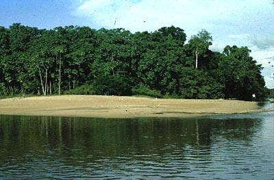
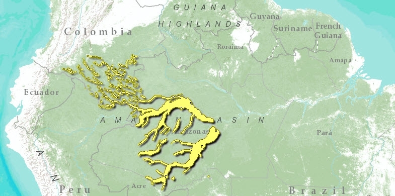
This ecoregion in Brazil comprises portions of the low, seasonally inundated river basins of the central Amazon, including the Solimões River (name for the Amazon west of Manaus in Brazil), much of the Juruá, central Purus, and Japura/Caquetá Rivers, (Amazon), as well as the smaller tributaries to these. The eastern limit of this ecoregion lies at an extensive area of várzea at the confluence of the Japura and Solimões Rivers, 600 kilometers (km) west of Manaus. The urban centers of Tefé, Tabatinga, and Carauarí lie in or near the várzea in this ecoregion. These flooded forests are called várzea because they are seasonally inundated by overflow from whitewater rivers . Whitewater rivers are those which carry a great deal of suspended organic and inorganic sediment and have an ochre color. The elevation along this region ranges from 80 to 120 meters (m). With 2,500 millimeters (mm) of precipitation annually and 12 m fluctuation in river level, the Purus várzea is a complex and dynamic region. The temperature on average is 29° C and varies more over the course of a day than over the year.
The substrate of the várzea is composed of alluvial and fluvial recent Holocene sediments (less than 10,000 years old) loosed from the eastern slopes of the Andes Mountains and carried in the powerful current of these mighty rivers. The rivers swell and overflow their banks each year from heavy seasonal rainfall in the catchments leaving the surrounding forest under 6 to 12 m of water for periods up to eight months each year. The nutrient rich sediments deposited on the landscape constantly renew the mineral richness of the várzea soils, rendering it much more fertile than the adjacent terra firme.
Both the geomorphology and biogeography in this region are influenced by very active fluvial dynamics. Over time (decades to centuries), the river course meanders across the floodplain making the várzea an ever-changing and heterogeneous landscape with a diversity of fluvial elements such as oxbow lakes, levees, meander swales, and point bars. The diversity of vegetation types found on the várzea reflects this landscape heterogeneity . Unlike the Upper Amazon Basin where the boundary between the várzea and terra firme is relatively indistinct, on the central Amazon floodplain the ecological difference between these forest types is more distinct. On the várzea, four vegetation types are defined and are delimited by the present and historical influence of the flood cycle. Three are on floodplain meanders, all resulting from the instability of the river courses: (1) sequences of successional vegetation, (2) forest mosaics, (3) and aquatic vegetation in poorly drained areas. The fourth type is permanent swamp vegetation in flooded river basins . The várzea forest performs critical ecological functions such as capturing and rapidly cycling nutrients, hosting a great diversity of freshwater fish and aquatic mammals, stabilizing the flooded soils and landscapes, and perhaps providing a source of new taxa that colonize the surrounding terra firme .
The várzea forest is continuous and has a rich understory with representatives from Zingiberaceae, Maranthaceae, and Heliconiaceae. These várzeas are richer in species (Species richness) than the várzea forests on the Lower Amazon. The floristic diversity of várzea forests tends to be lower than that of terra firme forests. There are many economically important tree species, such as the timber trees Carapa guianensis, Iryanthera surinamensis, Ceiba pentandra, and Calycophyllum spruceanum. Bactris tefensis is an endemic palm in this area. The most abundant trees on the levees are Ceiba pentandra, Hura crepitans, and Parinari excelsa, and on the low levee are Pterocarpus amazonicus, Eschweilera albiflora, Piranhea trifoliata, and Neoxythece elegans . Palms are relatively rare in these várzeas, as compared to upland forests, but include Astrocaryum jauari and A. murumuru, Bactris spp, and Mauritia flexuosa .
In the lowest areas, bamboo (Bambusa sp.) is abundant along with pioneer trees such as Cecropia spp., Pseudobombax munguba, numerous species of Ficus, and the palm Astrocaryum jauar. Virola surinamensis and Euterpe oleracea are restricted to flooded forests. Ceiba pentandra is the largest várzea tree and often has extensive buttress roots. Other trees characteristic of the várzea forest are Parkia inundabilis, Septotheca tessmannii, Coumarouna micrantha, Ceiba burchellii, Ochroma lagopus, and Manilkara inundata . The floodplain forests host a diversity of trees that produce fleshy fruit and are critical to the survival of fruit-eating fish that enter the forest understory during the flood. Some of these important trees include yellow mombim (Spondias mombim), jauari palm (Astrocaryum jauari), biribá (Rollinia deliciosa), tarumã (Vitex cymosa), and apui (Ficus spp.).
Biodiversity Features
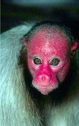
 The Red or White uakari. (Photograph by WWF-Canon/Edward Parker)
 In the region as a whole, 633 species of birds are reported. There are many aquatics, such as herons and egrets (Egretta and Ardea), ducks (Dendrocygna spp.), ibis (Cercibis spp., Theristicus spp.), and rosette spoonbills (Ajaia ajaia).
The mammal fauna of these flooded forests is relatively impoverished compared with adjacent upland habitat with 199 species reported for the region. There is a conspicuous absence of terrestrial mammals in isolated várzea forests where flooding precludes their existence year-round, and the river precludes migration. Where the várzea interdigitates with terra firme forest, terrestrial animals are more numerous as they are able to migrate seasonally. The Mamirauá Reserve is home to the two narrow endemics, white uakari monkeys (Cacajao calvus calvus) and blackish squirrel monkeys (Saimiri vanzolinii) . It also contains monk sakis (Pithecia albicans), endangered black-chinned emperor tamarins (Saguinus imperator), tamarins (Saguinus mystax), night monkeys (Aotus nancymaae), titi monkeys (Callicebus dubius), and bats (Scleronycteris ega) which have narrow distribution. Other mammals present include the peccaries (Tayassu spp.), agoutis (Dasyprocta spp.), pacas (Agouti paca), jaguars (Panthera onca), and the world’s largest rodents the capybaras (Hydrochoeris hydrochaeris). Various species of arboreal spiney rats (Echimys) are found in the floodplain forests in Upper Amazonia. The freshwater cetaceans, pink dolphins (Inia geoffrensis), grey dolphins (Sotalia fluviatilis), and manatees (Trichechus inunguis) are favorite aquatic mammals in these rivers.
Reptiles include the great anacondas (Eunectes murinus), black caimans (Melanosuchus niger) and spectacled caimans (Caiman crocodilus).
Very large fish live in these whitewater rivers and, during the flood season they roam through the flooded forest eating and dispersing fruits from the floodplain trees. These fish include the pacu (Metynnis and Mylossoma), tambaqui (Colossoma macropomum), pirarucu (Arapaima gigas), sardinha (Triportheus angulatus), and the smaller carnivorous characin, the pirana (Serrasalmus spp.). Many beautiful aquarium fish come from these rivers and blackwater tributaries and lakes in this region. They includes the discus fish (Symphsodon aequifasciata sp.), hundreds of cichlids such as in the genus Cichlasoma, assorted characins (family Anostomidae), tetras such as those in the genera Hemigrammus and Hyphessobrycon, and many catfish (families Aspredinidae, Corydoradinae, Doradidae, and Loricariidae).
Current Status
The várzea, because it lies along water "highways," is a region much affected by human activities, both historically and in the present. Today, the várzea is used for agriculture and forestry by smallholder farmers, and their systems tend to be biologically diverse agroecosystems. Hence, much of the forest is managed or unmanaged secondary forest. Small-scale ranching and extractive logging occur as well. Nevertheless, there is a certain amount of degraded deforested habitat. This region includes part of a large corridor of protected areas. They include the Mamirauá Sustainable Development Reserve that lies entirely within the várzea, Amanã National Park which is half igapó forest (flooded by blackwater systems) and half adjacent terra firme, and Jaú National Park on terra firme and some igapó (not in this ecoregion), together covering 57,090 km2 and protecting one of the most diverse aquatic ecosystems on Earth. These areas, particularly Mamirauá, have strong conservation programs.
Types and Severity of Threats
Large-scale fishing operations threaten fish populations. Over-collection of aquarium fish such as the discus (Symphysodon discus) also may threaten these populations. Gold mining occurring on the Purus and Japura Rivers results in mercury contamination of the water and its inhabitants. Large-scale cattle ranching and commercial logging threatens várzea forest in some areas.
Justification of Ecoregion Delineation
These are perhaps the most extensive of the várzea [[ecoregion]s] in the Americas. Delineations follow the ancient zones of uplift, and linework for eastern and western boundaries are derived from the locations of the Iquitos Arch and Purus Arch respectively. Linework for the extent of these seasonally flooded forests along the banks of the [[river]s] was derived from IBGE in Brazil (following "fluvial influence, alluvial vegetation" classifications) and Navarro et al within Colombia (classified as "Forest with marked homogeneous tendencies of alluvial species. In the Amazon, a poorly developed tree canopy and abundant palms and herbs" are characteristic). Northern delineations are the Amazon Basin occurrences of this várzea habitat type, and does not extend into Orinoco Basin. Southern delineation is the middle Acre River.
Additional Information on this Ecoregion
- For a shorter summary of this entry, see the WWF WildWorld profile of this ecoregion.
- To see the species that live in this ecoregion, including images and threat levels, see the WWF Wildfinder description of this ecoregion.
- World Wildlife Fund Homepage
Further Reading
- Ayres, J. M. 1995. As Matas de Várzea do Mamirauá: Médio Rio Solimoes. CNPq, Brasília, DF.
- Daly, D.C., and G.T. Prance. 1989. Brazilian Amazon. Pages 401-426 in D.G. Campbell, and H.D. Hammond, editors. Floristic inventory of tropical countries. New York Botanical Garden, Bronx, New York, USA. ISBN: 0893273333
- Daly, D. C., and J. D. Mitchell. 2000. Lowland vegetation of tropical South America. Pages 391-453 in D. L. Lentz, editor, Imperfect Balance: Landscape transformations in the Precolumbian Americas. New York: Columbia University Press.
- Ducke, A., and G. A. Black. 1953. Phytogeographical notes on the Brazilian Amazon. Anais da Academia Brasileira de Ciências 25: 1-46.
- Fundação Instituto Brasilero de Geografia Estatástica-IBGE. 1993. Mapa de vegetação do Brasil. Map 1:5,000,000. Rio de Janeiro, Brazil.
- Navarro, A.E.S., G.H. Peña, F.C. Lemus, J.R. Baquero, R.F. Soto. 1984. Bosques de Colombia. IGAC-INDERENA-CONIF, Bogota, Colombia.
- Peres, C. A. 1999. The structure of nonvolant mammal communities in different Amazonian forest types. Pages 564-581 in J. F. Eisenberg and K. H. Redford (editors), Mammals of the Neotropics: the Central Neotropics. Chicago: University of Chicago Press. ISBN: 0226195422
- Prance, G. T. 1979. Notes on the vegetation of Amazonia III. The terminology of Amazonian forest types subject to inundation. Brittonia 31: 26-38.
- Puhakka, M., and R. Kalliola. 1993. La vegatación en areas de inundación en la selva baja de la Amazonia Peruana. Pages 111-138 in R. Kalliola, M. Puhakka, and W. Danjoy, editors, Amazonia Peruana: vegetación húmeda tropical en el llano subandino. Turku: PAUT and ONERN.
- Silva, J.M. C. 1998. Um método para o estabelecimento de áreas prioritárias para a conservação na Amazônia Legal. Report prepared for WWF-Brazil. 17 pp.
| Disclaimer: This article is taken wholly from, or contains information that was originally published by, the World Wildlife Fund. Topic editors and authors for the Encyclopedia of Earth may have edited its content or added new information. The use of information from the World Wildlife Fund should not be construed as support for or endorsement by that organization for any new information added by EoE personnel, or for any editing of the original content. |

