Patía Valley dry forests
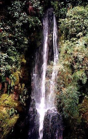
Near Popayán, Colombia Photograph by Luke Mastin
This small dry inter-Andean Valley in southwestern Colombia flanks the Patía River Valley and vicinity. Completely surrounded by the formidable barrier of the Andean chain, and encompassed by moist and cloud forests, this valley has remained isolated from similar habitats for long enough for speciation to occur among its flora and fauna. Like most of the dry valleys in the Andes, the Patía Valley is threatened by human settlement and urban sprawl.
Contents
Location and General Description
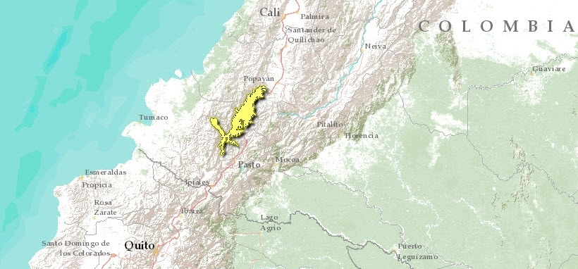
The Patía Valley is a dry pocket surrounded by the cloud forests of the Central and Western cordilleras, and it is dissected by the Patía river, which flows from the Central massif westwards and breaks the Western cordillera to drain into the Pacific ocean. The upper course of the Patía crosses mountain and cloud forests; then, in its middle course, forms the Patía dry valley, and after crossing the Western cordillera, drains into the Pacific after receiving much water from the Chocó jungles of the Pacific region of Colombia. This dry pocket has a unique set of plants and animals, proper to arid zones.
This valley is located between 1° 15’ N, 77° W and 2° 15’N, 77° 20’ W. It has a mean altitude between 600 and 900 meters above sea level (masl). Its climate is highly seasonal, with rainy seasons between April and June and between October and November. The mean rainfall is less than 900 millimeters (mm) per year.
The soils are of sedimentary origin, with pockets of volcanic ashes from nearby Puracé and Sotará volcanoes. The Patía is the main river but it receives the waters of the Quilcacé, Guachicono, Mayo, Juanambú, Pasto and Guaitara rivers.
The original vegetation has been decimated, due to human activities, mainly ranching and farming, with the aid of induced fires. Today, the most common vegetation is represented by Crescentia cujete, Guazuma ulmifolia, Cassia fistula, Bursera graveolens, Spondias mombin, Bauhinia picta, Ceiba pentandra and Gliricidia sepium. The cactus Pilosocereus colombianus is also present, along with Opuntia sp. The spectacular orchid Schomburgkia splendida grows on top of boulders and rock outcrops.
Biodiversity Features
Little is known about the flora and fauna of this valley. Although no endemism has been found at the species level, there are several sub-species of birds, butterflies and plants that are endemic to this valley. The hummingbird (Amazilia saucerottei australis) and the streaked saltator (Saltator albicollis flavidicollis) are two examples.
The mammal fauna was quite rich until recently; the collared peccary (Tayassu tajacu), the brocket deer (Mazama americana), the agouti (Dasyprocta punctata), the ocelot (Leopardus pardalis), and the puma (Puma concolor) still inhabit the most remote places along the valley.
The steep walls of the Juanambú and Guaitara [[river]s] were the nesting place of a relict population of the Andean Condor Vultur gryphus, today extinct in the region.
Current Status
Today most of the valley has suffered from human activity, but there are pockets with original vegetation that could be preserved; there are some conservation initiatives in private lands that can may conserve a good proportion of the original species. But in general, conservation initiatives are urgently needed in this valley.
If the current trend of use continues, very few original ecosystem could be left for conservation. Promotion of private conservation is one way to save what is left, and there is a Colombian NGO, the Network of Nature Reserves of the Civilian Society that is addressing this challenge.
Types and Severity of Threats
Threats include all the ramifications of human encroachment; overhunting, urban sprawl, conversion to agriculture, fuelwood overcollection, grazing livestock, and road building, among others.
Justification of Ecoregion Delineation
This small, dry, inter-Andean valley in southwestern Colombia is the most northerly occurrence of this forest type west of the Andes in South America. Because of its isolation from similar habitats, a number a endemic species persist. Delineation for this ecoregion did not follow vegetation maps as in other areas, and instead relied exclusively on expert opinion from ecoregion priority setting workshops, and the marked elevational limits to dry forests (1000m) based on cloud shadow effect.
Further Reading
- Complejo Ecoregional de los Andes del Norte (CEAN). Experts and ecoregional priority setting workshop. Bogota, Colombia, 24-26, July, 2000.
- Herández Camacho, Jorge, et al. 1992. Unidades biogeográficas de Colombia. In Gonzalo Halffte, editor, La diversidad biológica de Iberoamérica Mexico: Acta Zoológica Mexicana, CYTED-D.
- Hernández Camacho, Jorge. 1995. Desiertos, zonas áridas y semi-áridas de Colombia. Diego Samper Ediciones. Banco de Occidente, Colombia.
| Disclaimer: This article is taken wholly from, or contains information that was originally published by, the World Wildlife Fund. Topic editors and authors for the Encyclopedia of Earth may have edited its content or added new information. The use of information from the World Wildlife Fund should not be construed as support for or endorsement by that organization for any new information added by EoE personnel, or for any editing of the original content. |