Papua New Guinea
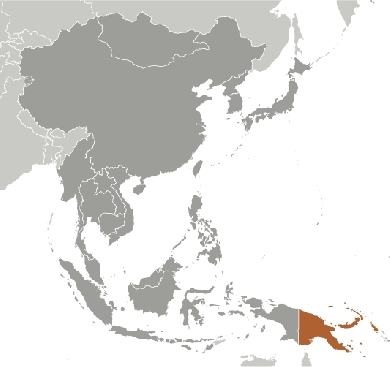
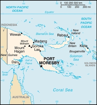
Countries and Regions of the World Collection  Papua New Guinea is a group of islands including the eastern half of the island of New Guinea (second largest island in the world which it share with Indonesia) between the Coral Sea and the South Pacific Ocean, east of Indonesia. It has a population of six-and-a-third million people.
Papua New Guinea has one of world's largest swamps along southwest coast.
Its major environmental issues include:
- rain forest subject to deforestation as a result of growing commercial demand for tropical timber;
- pollution from mining projects; and,
- severe drought
The indigenous population of Papua New Guinea is one of the most heterogeneous in the world. PNG has several thousand separate communities, most with only a few hundred people; divided by language, customs, and tradition, some of these communities have engaged in low-scale tribal conflict with their neighbors for millennia. The advent of modern weapons and modern migrants into urban areas has greatly magnified the impact of this lawlessness
Papua New Guinea was divided between Germany (north) and the UK (south) in 1885. The latter area was transferred to Australia in 1902, which occupied the northern portion during World War I and continued to administer the combined areas until independence in 1975.
A nine-year secessionist revolt on the island of Bougainville ended in 1997 after claiming some 20,000 lives.
Papua New Guinea is situated along the Pacific "Ring of Fire" and experiences severe volcanic activity; Ulawun (elev. 2,334 m), one of Papua New Guinea's potentially most dangerous volcanoes, has been deemed a "Decade Volcano" by the International Association of Volcanology and Chemistry of the Earth's Interior, worthy of study due to its explosive history and close proximity to human populations. Rabaul (elev. 688 m) destroyed the city of Rabaul in 1937 and 1994; Lamington erupted in 1951 killing 3,000 people; and, Manam's 2004 eruption forced the island's abandonment. Other historically active volcanoes include Bam, Bagana, Garbuna, Karkar, Langila, Lolobau, Long Island, Pago, St. Andrew Strait, Victory, and Waiowa.
Contents
Geography
Location: Oceania, group of islands including the eastern half of the island of New Guinea between the Coral Sea and the South Pacific Ocean, east of Indonesia
Geographic Coordinates: 6 00 S, 147 00 E
Area: total: 462,840 sq km (land: 452,860 sq km; water: 9,980 sq km)
Land Boundaries: 820 km (Indonesia)
Coastline: 5,152 km
Maritime Claims: measured from claimed archipelagic baselines
territorial sea: 12 nm
continental shelf: 200 m depth or to the depth of exploitation
exclusive fishing zone: 200 nm
Natural Hazards: active volcanism; situated along the Pacific "Ring of Fire"; the country is subject to frequent and sometimes severe earthquakes; mud slides; tsunamis
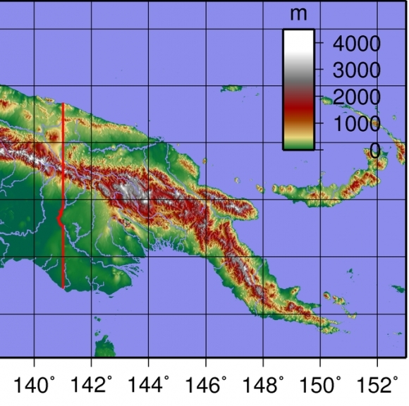
Terrain: mostly mountains with coastal lowlands and rolling foothills. The highest point is Mount Wilhelm (4,509 m)
Climate: tropical; northwest monsoon (December to March), southeast monsoon (May to October); slight seasonal temperature variation
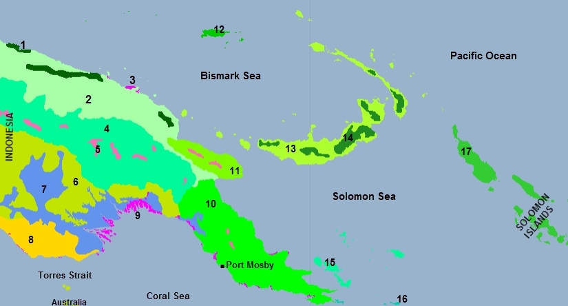
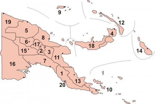
Topology of Papua New Guinea. Source: Wikimedia Commons.
Ecology and Biodiversity
1. Northern New Guinea montane rain forests
2. Northern New Guinea lowland rain and freshwater swamp forests
3. New Guinea mangroves
4. Central Range montane rain forests
5. Central Range sub-alpine grasslands
6.Southern New Guinea lowland rain forests
7. Southern New Guinea freshwater swamp forests
8. Trans Fly savanna and grasslands
9. New Guinea mangroves
10. Southern Papuan rain forests
11. Huan Peninsula montane rain forests
12. Admiralty Islands lowland rain forests
13. New Britain-New Ireland lowland rain forests
14. New Britain-New Ireland montane rain forests
15. Trobriand Islands rain forests
16. Louisiade Archipelago rain forests
17. Solomon Islands rain forests
See also:Biological diversity in the East Melanesian Islands
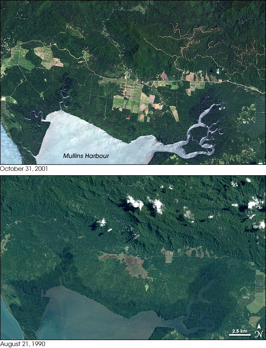
In June 2008, an international team of researchers released a report on the state of Papua New Guinea’s forests. The study summarized the findings from a five-year project in which the scientists compared high-resolution satellite imagery from the early 1970s and the early 2000s. The researchers found evidence of rapid deforestation and degradation, driven primarily by logging, subsistence agriculture, fires, and the development of mines and plantations. In 2001, some 362,000 hectares (3,620 square kilometers) were deforested or degraded. Recommending reforms to Papua New Guinea’s forest management, the study warned that, if current deforestation rates continued, the country might lose half its tree cover by 2021.
To conduct the study, researchers used satellite imagery from SPOT 4 and SPOT 5, operated by France’s Centre National d’Etudes Spatiales, and the Enhanced Thematic Mapper Plus (ETM+) on NASA’s Landsat satellites. These Landsat images show an area near the southeastern tip of mainland Papua New Guinea. Landsat 5 acquired the bottom image on August 21, 1990, and Landsat 7 acquired the top image on October 31, 2001. Consistent with the study’s findings, these images show an expansion of deforested areas.
The 1990 image shows relatively small areas of deforested land. The largest area appears near the center of the image, and it is linked by a road to a series of smaller deforested plots in the east. The 2001 image shows larger and more numerous deforested areas. In this image, the deforested land ranges in color from green to pale red-brown, suggesting a combination of cultivated crops, sparse vegetation, and bare ground. The network of roads has also increased dramatically, and one winding road cuts horizontally across the image, connecting with newly deforested areas in the west.
Along the eastern edge of the image, one area gives the appearance of forest recovery. In the 1990 image, this area appears pale green, clear evidence of deforestation. In the 2001 image, the same area is deep green like the surrounding forest. Close inspection, however, shows an array of rectangles outlining this area, and unlike the nearby forest, it has a smooth texture. This area likely supports mature plantation crops.
Some differences between these images result from the position of the Sun when the observations were made. The landscape appears more rugged and hilly in the 1990 image, due to lengthened shadows. The lighter color of the water in the 2001
Source: NASA. Image created by Jesse Allen, using Landsat data provided by the University of Maryland’s Global Land Cover Facility. Caption by Michon Scott.
|
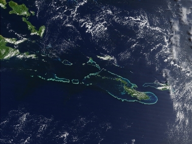
Offthe southeast tip of Papua New Guinea lies a string of small volcanicislands and coral reefs collectively called the Louisiade Archipelago. This true-color MODIS image from September 11, 2002, is centered on theisland chain, with Papua New Guinea at the left edge. Moving westward fromeastern end of the chain are the islands of Rossel and Tagula. (MisimaIsland, which harbors the largest village in the region, is obscured by apatch of clouds northeast of image center.) To the north of the chain liesthe Solomon Sea, and to the south is the Coral Sea. Most of theundisturbed land is covered by tropical rainforest, and despite theirsmall size, the islands harbor a number of plant and animal species foundnowhere else. Source: NASA. Jacques Descloitres, MODIS Rapid Response Team,NASA/GSFC |
|
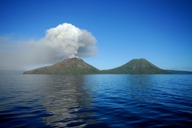
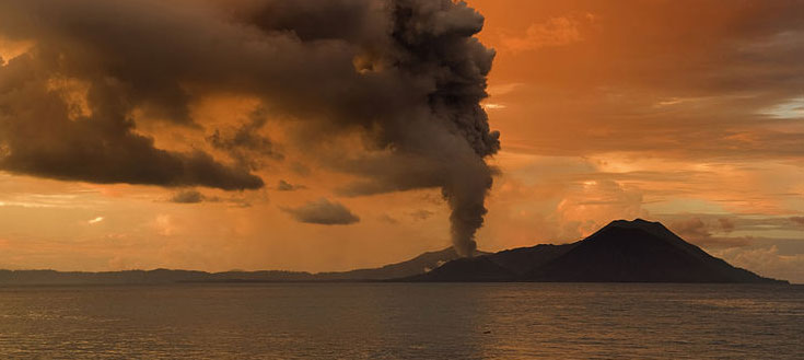
Mount Tavurvur, a part of the Rabaul caldera volcano, in Papua New Guinea. Source: Taro Taylor/Flickr |
People and Society
Population: 6,310,129 (July 2012 est.)
The indigenous population of Papua New Guinea is one of the most heterogeneous in the world. Papua New Guinea has several thousand separate communities, most with only a few hundred people. Divided by language, customs, and tradition, some of these communities have engaged in low-scale tribal conflict with their neighbors for millennia. The advent of modern weapons and modern migration into urban areas has greatly magnified the impact of this lawlessness.
The isolation created by the mountainous terrain is so great that some groups, until recently, were unaware of the existence of neighboring groups only a few kilometers away. The diversity, reflected in a folk saying, "For each village, a different culture," is perhaps best shown in the local languages. Spoken mainly on the island of New Guinea--composed of Papua New Guinea and the Indonesian province of West Papua--over 850 of these languages have been identified; of these, only 350-450 are related. The remainder seem to be totally unrelated either to each other or to the other major groupings. Most native languages are spoken by a few hundred to a few thousand, although Enga, used in part of the highlands, is spoken by some 130,000 people. However, the Enga people are subdivided into clans that regularly conflict with each other. Many native languages are extremely complex grammatically.
Melanesian Pidgin (Tok Pisin) serves as the lingua franca. English is spoken by educated people and in the Central and Milne Bay Provinces. The overall population density is low, although pockets of overpopulation exist. Papua New Guinea's Western Province averages one person per square kilometer (3 per sq. mi.). The Chimbu Province in the New Guinea highlands averages 20 persons per square kilometer (60 per sq. mi.) and has areas containing up to 200 people farming a square kilometer of land. The highlands are home to 40% of the population.
A considerable urban drift toward Port Moresby and other major centers has occurred in recent years. The trend toward urbanization accelerated in the 1990s, bringing in its wake squatter settlements, ethnic disputes, unemployment, public utilities pressure, and attendant social problems, especially violent crime.
Approximately 96% of the population is Christian. The churches with the largest number of members are the Roman Catholic Church, the Evangelical Lutheran Church, the United Church, the Seventh Day Adventist church, and the Anglican Church. Although the major churches are under indigenous leadership, a large number of missionaries remain in the country. The bulk of the estimated 2,000 Americans resident in Papua New Guinea are missionaries and their families. The non-Christian portion of the indigenous population, as well as a portion of the nominal Christians, practices a wide variety of religions that are an integral part of traditional culture, mainly animism (spirit worship) and ancestor cults.
Foreign residents comprise about 1% of the population. More than half are Australian; others are from China, the United Kingdom, New Zealand, the Philippines, India, and the United States, most of whom are missionaries. Since independence, about 900 foreigners have become naturalized citizens.
Though cultures vary widely, traditional Papua New Guinea social structures generally include the following characteristics:
- The practice of subsistence economy;
- Recognition of bonds of kinship with obligations extending beyond the immediate family group;
- Generally egalitarian relationships with an emphasis on acquired, rather than inherited, status; and
- A strong attachment of the people to land, which is held communally. Traditional communities do not recognize a permanent transfer of ownership when land is sold.
- Though land and other possessions may be inherited through the female line in some cultures, women generally are considered and treated as inferiors. Gender violence is endemic.
- Patterns and frequency of sexual activity, though never publicly discussed (especially in rural areas), contribute to the current rapid spread of HIV.
Most Papua New Guineans still adhere strongly to this traditional social structure, which has its roots in village life.
Ethnic Groups: Melanesian, Papuan, Negrito, Micronesian, Polynesian
Age Structure:
0-14 years: 36.4% (male 1,145,946/female 1,106,705)
15-64 years: 60% (male 1,907,787/female 1,802,144)
65 years and over: 3.6% (male 121,207/female 103,802) (2011 est.)
Population Growth Rate: 1.936% (2012 est.)
Birthrate: 25.92 births/1,000 population (2012 est.)
Death Rate: 6.56 deaths/1,000 population (July 2012 est.)
Net Migration Rate: 0 migrant(s)/1,000 population (2012 est.)
Life Expectancy at Birth: 66.46 years
male: 64.23 years
female: 68.79 years (2012 est.)
Total Fertility Rate: 3.39 children born/woman (2012 est.)
Languages: Tok Pisin (official), English (official), Hiri Motu (official), some 860 indigenous languages spoken (over one-tenth of the world's total). Note: Tok Pisin, a creole language, is widely used and understood; English is spoken by 1%-2%; Hiri Motu is spoken by less than 2%
Literacy (age 15 and over can read and write): 57.3% (2000 census)
Urbanization: 13% of total population (2010) growing at an annual rate of change of 2.9% (2010-15 est.)
History
Archeological evidence indicates that humans arrived on New Guinea at least 60,000 years ago, probably by sea from Southeast Asia during an Ice Age period when the sea was lower and distances between islands shorter. Although the first arrivals were hunters and gatherers, early evidence shows that people managed the forest environment to provide food. There also are indications of gardening having been practiced at the same time that agriculture was developing in Mesopotamia and Egypt. Early garden crops--many of which are indigenous--included sugarcane, Pacific bananas, yams, and taros, while sago and pandanus were two commonly exploited native forest crops. Today's staples--sweet potatoes and pigs--were later arrivals, but shellfish and fish have long been mainstays of coastal dwellers' diets.
When Europeans first arrived, inhabitants of New Guinea and nearby islands--while still relying on bone, wood, and stone tools--had a productive agricultural system. They traded along the coast, where products mainly were pottery, shell ornaments, and foodstuffs, and in the interior, where forest products were exchanged for shells and other sea products.
The first Europeans to sight New Guinea were probably the Portuguese and Spanish navigators sailing in the South Pacific in the early part of the 16th century. In 1526-27, Don Jorge de Meneses accidentally came upon the principal island and is credited with naming it "Papua," a Malay word for the frizzled quality of Melanesian hair. The term "New Guinea" was applied to the island in 1545 by a Spaniard, Inigo Ortiz de Retes, because of a fancied resemblance between the islands' inhabitants and those found on the African Guinea coast. Although European navigators visited the islands and explored their coastlines for the next 170 years, little was known of the inhabitants until the late 19th century.
New Guinea
With Europe's growing need for coconut oil, Godeffroy's of Hamburg, the largest trading firm in the Pacific, began trading for copra in the New Guinea Islands. In 1884, Germany formally took possession of the northeast quarter of the island and put its administration in the hands of a chartered company. In 1899, the German imperial government assumed direct control of the territory, thereafter known as German New Guinea. In 1914, Australian troops occupied German New Guinea, and it remained under Australian military control until 1921. The British Government, on behalf of the Commonwealth of Australia, assumed a mandate from the League of Nations for governing the Territory of New Guinea in 1920. That mandate was administered by the Australian Government until the Japanese invasion in December 1941 brought about its suspension. Following the surrender of the Japanese in 1945, civil administration of Papua as well as New Guinea was restored, and under the Papua New Guinea Provisional Administration Act, 1945-46, Papua and New Guinea were combined in an administrative union.
Papua
On November 6, 1884, a British protectorate was proclaimed over the southern coast of New Guinea (the area called Papua) and its adjacent islands. The protectorate, called British New Guinea, was annexed outright on September 4, 1888. The possession was placed under the authority of the Commonwealth of Australia in 1902. Following the passage of the Papua Act of 1905, British New Guinea became the Territory of Papua, and formal Australian administration began in 1906. Papua was administered under the Papua Act until the Japanese invaded the northern parts of the islands in 1941 and began to advance on Port Moresby and civil administration was suspended. During the war, Papua was governed by a military administration from Port Moresby, where Gen. Douglas MacArthur occasionally made his headquarters. As noted, it was later joined in an administrative union with New Guinea during 1945-46 following the surrender of Japan.
Postwar Developments
The Papua and New Guinea Act of 1949 formally approved the placing of New Guinea under the international trusteeship system and confirmed the administrative union of New Guinea and Papua under the title of "The Territory of Papua and New Guinea." The act provided for a Legislative Council (established in 1951), a judicial organization, a public service, and a system of local government. A House of Assembly replaced the Legislative Council in 1963, and the first House of Assembly opened on June 8, 1964. In 1972, the name of the territory was changed to Papua New Guinea.
Elections in 1972 resulted in the formation of a ministry headed by Chief Minister Michael Somare, who pledged to lead the country to self-government and then to independence. Papua New Guinea became self-governing in December 1973 and achieved independence on September 16, 1975. The 1977 national elections confirmed Somare as Prime Minister at the head of a coalition led by the Pangu Party. However, his government lost a vote of no confidence in 1980 and was replaced by a new cabinet headed by Julius Chan as Prime Minister. The 1982 elections increased Pangu's plurality, and parliament again chose Somare as Prime Minister. In November 1985, the Somare government lost a vote of no confidence, and the parliamentary majority elected Paias Wingti as Prime Minister at the head of a five-party coalition. A coalition headed by Wingti was victorious in very close elections in July 1987. In July 1988 a no-confidence vote toppled Wingti and brought to power Rabbie Namaliu, who a few weeks earlier had replaced Somare as leader of the Pangu Party. In 1992 Wingti was elected Prime Minister. Chan took his place in 1994 after a vote of no confidence. The 1997 elections brought Bill Skate to power as Prime Minister, but he was replaced by Mekere Morauta after a vote of no confidence in 1999.
Somare returned as Prime Minister after the 2002 general elections. He led his National Alliance party into the 2007 elections and remained Prime Minister, becoming the longest-serving parliamentarian in the Commonwealth. Somare's government was the first to complete a 5-year term since independence and hoped to complete a 10-year term. Sixty-six members of parliament (MPs) lost their seats in the 2007 elections, and the government was formed by a coalition of several parties.
On August 2, 2011 Peter O’Neill was elected prime minister when the speaker of parliament declared the premiership vacant due to the prolonged illness and absence of Somare. On December 12 the Supreme Court declared O’Neill’s election unconstitutional and restored Somare as prime minister. On the same day, parliament disqualified Somare as a member of parliament and re-elected O’Neill as prime minister.
The next national elections will be held in 2012.
Political Conditions
Papua New Guinea's politics are highly competitive with most members elected on a personal and ethnic basis within their constituencies rather than as a result of party affiliation. There are several parties, but party allegiances are not strong. Winning independent candidates are usually courted in efforts to forge the majority needed to form a government, and allegiances are fluid. No single party has yet won enough seats to form a government in its own right. New governments are protected by law from votes of no confidence for the first 18 months of their incumbency, and no votes of no confidence may be moved in the 12 months preceding a national election.
Reversals of fortune and a revolving-door succession of prime ministers have characterized Papua New Guinea's national politics. The country has a history of changes in government coalitions and leadership from within parliament during the 5-year intervals between national elections. From 1988 to 2002, the country had numerous prime ministers. A plethora of political parties, coalition governments, shifting party loyalties, and motions of no confidence in the leadership all lent an air of instability to political proceedings. For the first 27 years of independence, a "first past the post" electoral system resulted in many parliamentarians elected with less than 15% of their constituency. Fractious politics and a 75% loss rate for incumbents precluded the development of strong political parties or a stable national leadership.
In an effort to create greater stability by reducing incessant votes of no confidence, the Organic Law on the Integrity of Political Parties and Candidates (OLIPPAC) was passed in 2001, forbidding members of each party in parliament from shifting loyalty to another party. In 2003, the electoral system for MPs was changed to limited preferential voting, which began to encourage politicians to strike alliances and to be responsive to constituent concerns once elected. The new system was used in the 2007 national general elections, although 53 election petitions disputing returns were registered with the courts. Allegations included bribery, intimidation, bloc voting, and undue influence.
In July 2010, the Supreme Court ruled certain provisions of the OLIPPAC unconstitutional, including those requiring MPs to vote along party lines on matters such as the budget and motions of no confidence and restricting MPs from resigning and joining other political parties. Soon after the Supreme Court ruling, three government ministers, including Deputy Prime Minister Puka Temu, resigned from the government and joined the opposition in an unsuccessful bid to move a vote of no confidence against Prime Minister Somare.
On Bougainville Island, a 10-year rebellion was halted by a truce in 1997 and a permanent cease-fire was signed in April 1998. A peace agreement between the government and ex-combatants was signed in August 2001. Under the eyes of a regional peace-monitoring force and a UN observer mission, the government and provincial leaders established an interim administration and made significant progress toward complete surrender/destruction of weapons. A constitution was drafted in 2004 and provincial government elections were held in May 2005. The elections were deemed to be free and fair by international observers, and Joseph Kabui was elected to serve as the first president of the Autonomous Bougainville Government (ABG). Bougainvilleans also participated in Papua New Guinea national elections in 2007 to elect representatives to the national parliament. Kabui died of a heart attack in June 2008. James Tanis was elected President of the ABG in December 2008. Presidential and parliamentary elections were held in May 2010, and John Momis was elected President. A referendum was tentatively agreed to be held between 2015 and 2020, 10 to 15 years following formation of the ABG. Progress has been slow with the ABG initially focusing on disarmament, peace, and reconciliation. A small percentage of former fighters have created illegal "no go zones," particularly in the Central and South Bougainville.
Government
Government Type: constitutional parliamentary democracy and a Commonwealth realm
Papua New Guinea, a constitutional parliamentary democracy, recognizes Queen Elizabeth II as head of state. She is represented by a governor general who is elected by parliament and who performs mainly ceremonial functions. Papua New Guinea has three levels of government--national, provincial, and local. Members of the unicameral parliament are elected every 5 years. In 2010 two provinces were created--Hela and Jiwak--increasing parliamentary seats to 111 from 109. The parliament elects the prime minister, who appoints his cabinet from members of his party or coalition.
Members of parliament are elected from 21 provinces and the national capital district of Port Moresby. Parliament introduced reforms in June 1995 to change the provincial government system, with regional (at-large) members of parliament becoming provincial governors, while retaining their national seats in parliament.
Papua New Guinea's judiciary is independent of the government. It protects constitutional rights and interprets the laws. There are several levels, culminating in the Supreme Court.
Capital: Port Moresby - 314,000 (2009)
|
Administrative divisions: 18 provinces, 1 autonomous region*, and 1 district**
|
Independence Date: 16 September 1975 (from the Australian-administered UN trusteeship)
Legal System: mixed legal system of English common law and customary law. Papua New Guinea has not submitted an International Court of Justice (ICJ) jurisdiction declaration; and is a non-party state to the International criminal court (ICCt)
International Environmental Agreements
Papua New Guinea is party to international agreements on: Antarctic Treaty, Biodiversity, Climate Change, Climate Change-Kyoto Protocol, Desertification, Endangered Species, Environmental Modification, Hazardous Wastes, Law of the Sea, Marine Dumping, Ozone Layer Protection, Ship Pollution, Tropical Timber 83, Tropical Timber 94, and Wetlands.
Water
Total Renewable Water Resources: 801 cu km (1987)
Freshwater Withdrawal: 0.1 cu km/yr (56% domestic, 43% industrial, 1% agricultural)
Per Capita Freshwater Withdrawal: 17 cu m/yr (1987)
Access to improved sources of drinking water: total: 40% of population
Access to improved sanitation facilities: 45% of population
See: Water profile of Papua New Guinea
Resources
Natural Resources: gold, copper, silver, natural gas, timber, oil, fisheries
Land Use:
arable land: 0.49%
permanent crops: 1.4%
other: 98.11% (2005)
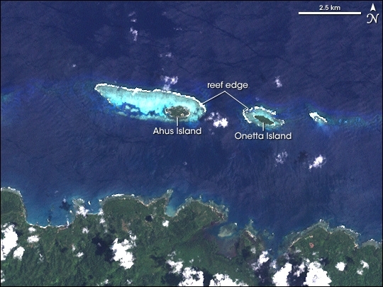
While many fish stocks around the world are in peril, fish have been doing well in parts of Papua New Guinea. To maintain healthy fish stocks, the people who rely on these fish for food and trade didn’t turn to some new technology. Instead, they turned to the past. Inhabitants of Ahus Island, Manus Province, Papua New Guinea, have followed a generations-old practice of restricting fishing in six areas of their reef lagoon. While line fishing is permitted, net and spear fishing are restricted based on cultural traditions. The result is that both the biomass (the total weight of the organisms) and individual fish sizes are significantly larger in these areas than in places where fishing is completely unrestricted.
Ahus Island lies in the Admiralty Islands chain off the northern coast of Papua New Guinea, roughly 30 kilometers from the provincial capital, Lorengau. The Enhanced Thematic Mapper Plus (ETM+) instrument on NASA’s Landsat satellite captured this true-color image of Ahus Island on February 20, 2000. In this image, coral reefs stand out from their surroundings because of their shallower waters, shown in aquamarine. Exposed or shallow reefs at the reef edges tend to cause ocean waves to break, showing white foam as the cresting waves appear. White puffy clouds appear throughout the scene. The dense green forests on Manus Island contrast sharply with the dark blue of deep ocean and the aquamarine color of shallow areas. In the large format image, roads in the hills of Manus Island appear in brown and generally follow the tops of ridges.
Even though traditional management of the reefs shown here preserved fish and increased individual fish sizes, these were not the primary motivations for the practice, said the group of biologists who discovered the benefit of fishing restrictions on Ahus Island. Describing their findings in Conservation Biology in 2005, the group said that cultural practices restrict fishing in parts of the reef—sometimes for a period of years—after the death of a prominent individual. After the mourning period ends, inhabitants celebrate with a feast, harvesting the fish they have avoided catching though spear or net fishing. By avoiding over-fishing these stocks, the residents ensure a big supply of food for the celebration. The healthy fish stock also gives the islanders something to trade with mainland village neighbors for goods such as vegetables and timber. Maintaining good trade relations is an important supplement to the livelihoods of the islanders since their agricultural prospects are limited by land shortages and poor soil.
Source: NASA. image created by Jesse Allen, Earth Observatory, using data provided by Timon McPhearson, American Museum of Natural History,
Economy
Papua New Guinea is rich in natural resources, including minerals, oil, gas, timber, and fish, and produces a variety of commercial agricultural products. The economy generally can be separated into an informal sector centered on subsistence agriculture and a formal sector centered on resources. Approximately 75% of the country's population relies primarily on the subsistence economy. The minerals, timber, and fish sectors are dominated by foreign investors.
Mineral and Oil Resources
Papua New Guinea is richly endowed with gold, copper, oil, natural gas, and other minerals. In 2006 minerals and oil export receipts accounted for 82% of GDP and continue to account for over 60% of GDP. Government revenues and foreign exchange earnings depend heavily on mineral and oil exports. Indigenous landowners in areas affected by minerals projects also receive royalties from those operations. Copper and gold mines are currently in production at Porgera, Ok Tedi, Lihir, Hidden Valley, Sinivit, and Simberi. A consortium led by ExxonMobil signed a final investment decision in December 2009 to begin the commercialization of the country's estimated 22.5 trillion cubic feet of natural gas reserves through the construction of a liquefied natural gas (LNG) production facility. Interoil, an American-owned firm, opened Papua New Guinea's first oil refinery in 2004 and is also building a second liquefied natural gas production facility which it aims to complete by 2012 with production capacity of 32,500 barrels of product per day. The government faces the challenge of ensuring transparency and accountability for revenues flowing from this and other large LNG projects.
Agriculture, Timber, and Fish
Papua New Guinea also produces and exports valuable agricultural, timber, and marine products. Agriculture currently accounts for 32% of GDP and supports more than 75% of the population. Cash crops ranked by value are coffee, oil, cocoa, copra, tea, rubber, and sugar. About 40% of the country is covered with exploitable trees, but a domestic woodworking industry has been slow to develop. A number of Southeast Asian companies are active in the timber industry, but World Bank and other donors have withdrawn support from the sector over concern about unregulated deforestation and environmental damage. Recently enacted forestry legislation has exacerbated those concerns. Papua New Guinea has an active tuna industry, but much of the catch is made by boats of other nations fishing in Papua New Guinea waters under license. Papua New Guinea is a signatory to the South Pacific Tuna Treaty (SPTT), under which U.S. purse seiners fish for tuna in the exclusive economic zones (EEZs) of the Pacific Island parties. Locally produced fish exports are confined primarily to shrimp.
Industry
In general, the Papua New Guinea economy is highly dependent on imports for manufactured goods. Its industrial sector--exclusive of mining--accounts for only 9% of GDP and contributes little to exports. Small-scale industries produce beer, soap, concrete products, clothing, paper products, matches, ice cream, canned meat, fruit juices, furniture, plywood, and paint. The small domestic market, relatively high wages, and high transport costs are constraints to industrial development.
Trade and Investment
Australia, Singapore, and Japan are principal exporters to Papua New Guinea. Petroleum and mining machinery and aircraft have been the strongest U.S. exports to Papua New Guinea.
Australia is Papua New Guinea's most important export market, followed by Japan, China and the European Union. The U.S. imports modest amounts of gold, copper ore, cocoa, coffee, and other agricultural products from Papua New Guinea. Most of those exports take place through third countries.
With the 2003 withdrawal of Chevron/Texaco, Australian companies are the most active in developing Papua New Guinea's mining and petroleum sectors. ExxonMobil retains a major share of natural gas reserves and is constructing a liquefied natural gas processing facility. Interoil, backed by an Overseas Private Investment Corporation (OPIC) loan, operates an oil refinery in Port Moresby and in September 2010 signed an agreement with Energy World Corporation (EWC) to complete front-end engineering and design and a final investment decision to establish the second LNG project in the country. China is increasing its investment in Papua New Guinea, including development of the $1 billion Ramu nickel mine. Shell opened a representative office in Port Moresby in February 2012 and will be involved in building an upstream business in the country.
Papua New Guinea became a participating economy in the Asia-Pacific Economic Cooperation (APEC) Forum in 1993. It joined the World Trade Organization (WTO) in 1996. It is an observer at ASEAN and a member of the ASEAN Regional Forum. It has preferential tariff agreements with the markets of Melanesian and Pacific Island neighbors through the Melanesian Spearhead Group (MSG) Trade Agreement and the Pacific Islands Countries Trade Agreement (PICTA).
Development Programs and Aid
Australia is by far the largest bilateral aid donor to Papua New Guinea, offering about $480 million a year in assistance. Budgetary support, which had been provided in decreasing amounts since independence, was phased out in 2000, with aid concentrated on project development. In 2004, Australia and Papua New Guinea embarked on the Enhanced Cooperation Program (ECP), under which Australia agreed to provide direct assistance, including 210 line police officers, to the Papua New Guinea constabulary. The ECP met with initial success, but was abruptly ended when Papua New Guinea's Supreme Court stripped Australian police officers of immunity in May 2005. Virtually all ECP personnel left Papua New Guinea following the court's decision. The governments of Papua New Guinea and Australia are now involved in protracted negotiations on a scaled-down version of the ECP.
Other major sources of aid to Papua New Guinea are Japan, the European Union, the People's Republic of China, Taiwan, the United Nations, the Asian Development Bank, the International Monetary Fund, and the World Bank. Volunteers from a number of countries and mission church workers also provide education, health, and development assistance throughout the country. Foreign assistance to Papua New Guinea is approximately $46 per capita. The U.S. funds a $1.5 million-per-year HIV/AIDS project in Papua New Guinea.
Current Economic Conditions
After years of decline and government deficit, Papua New Guinea was bolstered by a general rise in commodity prices and by government steps toward spending control. Economic activity accelerated in 2010, resulting in 8% economic growth compared to 5.5% in 2009. The economy was expected to grow by 9% for 2011, largely due to the start of construction on the U.S. $15 billion liquefied natural gas project led by ExxonMobil as well as a recovery in international commodity prices. However, the economic improvements are based almost entirely on high commodity prices, and the nation continues to have serious problems of corruption, a lack of law and order, and land tenure concerns stifling investment. In February 2012 the national parliament passed a bill to establish a Sovereign Wealth Fund (SWF) offshore to manage government surplus wealth from mineral, oil, and gas projects.
The government of Prime Minister Somare has expended much of its energy remaining in power. He was the first prime minister ever to serve a full five-year term. The government has brought stability to the national budget, largely through expenditure control; however, it relaxed spending constraints in 2006 and 2007 as elections approached.
In recent years, the government has opened up markets in telecommunications and air transport, making both more affordable to the people.
Numerous challenges still face the government, including providing physical security for foreign investors, regaining investor confidence, restoring integrity to state institutions, promoting economic efficiency by privatizing moribund state institutions, and balancing relations with Australia, its former colonial ruler.
Other socio-cultural challenges could upend the economy including an HIV/AIDS epidemic, with the second highest infection rate in all of East Asia and the Pacific, and chronic law and order and land tenure issues.
The global financial crisis had little impact because of continued foreign demand for PNG's commodities.
GDP: (Purchasing Power Parity): $16.7 billion (2011 est.)
GDP: (Official Exchange Rate): $11.4 billion (2011 est.)
GDP- per capita (PPP): $2,500 (2011 est.)
GDP- composition by sector:
agriculture: 30.3%
industry: 37.7%
services: 32.1% (2011 est.)
Agricultural products: coffee, cocoa, copra, palm kernels, tea, sugar, rubber, sweet potatoes, fruit, vegetables, vanilla; shell fish; poultry, pork
Industries: copra crushing, palm oil processing, plywood production, wood chip production; mining of gold, silver, and copper; crude oil production, petroleum refining; construction, tourism
Currency: Kina (PGK)
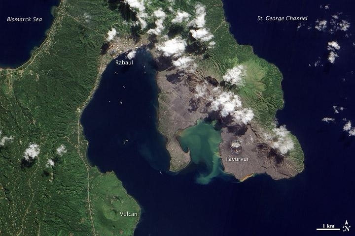
Volcanic cones and settlements mingle along the margins of the Rabaul Caldera on the northeastern tip of Papua New Guinea's New Britain Island. Shaped like a giant cauldron, the caldera is the remaining rim of an ancient volcano. Small volcanic cones, some of which are still active, sit on the rim. Spanning roughly 8 by 14 km (5 by 9 mi), the caldera is flooded by Blanche Bay. The largely submerged caldera long formed a natural harbor for what had been New Britain's largest city, but a major eruption forced the evacuation of Rabaul City in 1994. Although the city ceased to bustle with activity, at least one volcanic cone remained active for years afterward. The landscape in this satellite image appears as a mixture of vegetated and bare ground. Vegetation almost completely coats the western side of Rabaul Caldera. Volcanic cones line the northeastern margin of the caldera, and around these cones, the land is mostly rocky and barren. Tavurvur, near the southern end of the exposed caldera rim, was one of the volcanoes to erupt explosively in 1994. The other was Vulcan, on the western side of the caldera. While vegetation has revived on the slopes of Vulcan, rocks predominate at Tavurvur, evidence of more recent eruptive activity. Remnants of settlements linger along the caldera's northwestern margin and on a promontory near the caldera's center. Prior to the explosive eruption in 1994, the city of Rabaul had been the provincial capital of East New Britain. After the eruption, the capital was moved to the coastal city of Kokopo, some 20 km (12 mi) to the southeast. Photo courtesy of NASA.
