Southern New Guinea freshwater swamp forests
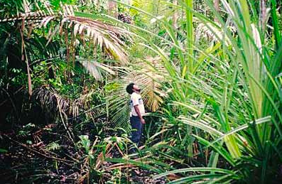
Southern New Guinea freshwater swamp forests Near Veiru, Gulf Province, Papua New Guinea (Photograph by John Morrison via Flickr)
Introduction The Southern New Guinea freshwater swamp forests, a unique mosaic of swamp (Southern New Guinea freshwater swamp forests) grassland, savanna, gallery forest, and lakes (including Papua New Guinea's (PNG's) largest lake, Lake Murray), represent wetlands for resident waterfowl and staging areas for those migrating from Australia. With the exception of the largest mine in PNG, much of this lightly populated ecoregion is still relatively intact. However, this ecoregion faces challenges from exotic species.
Location and General Description
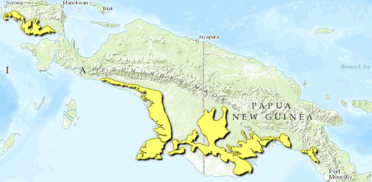
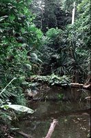 Lakekamu River basin, Papua New Guinea. (Photograph by John P. Dumbacher) This ecoregion is made up of the freshwater swamp forests associated with low-gradient river systems (Purari and Fly rivers) along the southern coast of New Guinea. The ecoregion consists of a large extent in south-central Irian Jaya and PNG and a smaller, disjunct patch along the southern coast of the Vogelkop Peninsula in Irian Jaya. The climate of the ecoregion is tropical wet, which is characteristic of this part of Melanesia, located in the western Pacific Ocean north of Australia. Although the rainfall here is lower than in most parts of New Guinea, the area's low relief and large [[river]s] draining the nearby Central Ranges result in this ecoregion's inundation during the wet season. The wetland system associated with the Fly River is the largest watershed in PNG. Although New Guinea is a very active tectonic area with a complex geologic history, the geology of the West Papuan shelf, where this ecoregion is located, shows little folding, an indication of relative stability. The surface geology of the ecoregion consists of alluvium on active and relict alluvial plains and fans.
The freshwater swamps along the southern lowlands are made up of several habitat types, ranging from purely aquatic to herbaceous vegetation, grass swamps, savannas, and woodlands to swamp forests. The mosaic of habitats in lowland freshwater swamps includes herbaceous swamp vegetation, Leersia grass swamp, Saccharum-Phragmites grass swamp, Pseudoraphis grass swamp, mixed swamp savanna, Melaleuca swamp savanna, mixed swamp woodland, sago swamp woodland, pandan swamp woodland, mixed swamp forest, Campnosperma swamp forest, Teminalia swamp forest, and Melaleuca swamp forest. The ecoregion is composed of approximately 32 percent freshwater swamp forest, 28 percent grasslands, and 13 percent peat swamp forest, with the remainder being wet forest, dry forest, or cleared land.
The water table is near or above the ground surface but may fluctuate widely. The structure of swamp forests range from very small-crowned to medium-crowned, dense to open, with a 20- to 30-meter (m) canopy of an even height. Sago palm (Metroxylon sagu) and Pandanus spp. generally are present in the subcanopy. Canopy trees of the swamp forest include Campnosperma brevipetiolata, C. auriculata, Terminalia canaliculata, Nauclea coadunata, and Syzygium spp., with Myristica hollrungii in delta areas. However, although some swamp forests are almost pure stands of Campnosperma or Melaleuca, others are species-rich, and many other tree species are possible.
 WWF Two sets of a total of five small, 1-hectare (ha) plots have been inventoried in Lakekamu Basin in PNG. One of these forest plots was in hill forest (175-260 m elevation), which was surveyed on the margins of the ecoregion, and this plot may or may not be more representative of the Southern New Guinea lowland rain forests. The hill forest plot contained less diversity than the alluvial plots. The hill forest plot was dominated by members of the Myrtaceae and Lauraceae families (25 percent of the species and 40 percent of the stems), whereas the corresponding lowland plot did not contain such dominants. Both plots contained many rare species and a few fairly common ones. Although all five of the plots are found in continuous, closed forest and none of the plots are more than 20 kilometers (km) apart, they all exhibit considerable differences in species composition and structure.
The taller grasses usually are Leersia, Saccharum, and Phragmites. Sago palms (Metroxylon sagu) form woodlands, especially in areas that have freshwater influxes, with Pandanus being more common in areas that are more saline. Seasonally inundated areas, especially in the fluctuating backswamps of the Middle Fly and Strickland rivers, are characterized by Melaleuca woodlands. The dominant tree species is Melaleuca cajuputi, a highly fire-resistant species that forms an even canopy. Other common trees in the open woodlands include Nauclea, Campnosperma, Syzygium, Melaleuca, and Carallia, mixed with Terminalia, Alstonia, Barringtonia, Diospyros, Pandanus, and Myristica in deltaic regions.
Biodiversity Features
|
Table 1. Endemic and Near-Endemic Mammal Species. Family Species Macropodidae Dendrolagus spadix Macropodidae Dorcopsis luctuosa Macropodidae Thylogale brunii Peroryctidae Echymipera echinista Vespertilionidae Kerivoula muscina Muridae Leptomys signatus* An asterisk signifies that the species' range is limited to this ecoregion. Overall richness (Southern New Guinea freshwater swamp forests) and endemism generally are low to moderate when compared with those of other ecoregions in Indo-Malaysia. Reptile and amphibian richness, though poorly studied, is thought to be high. The mammalian fauna consists of a wide variety of tropical Australasian marsupials, including a tree kangaroo. Fifty mammal species are found in the ecoregion, including six endemics and near endemics (Table 1). The Fly River leptomys (Leptomys signatus) is considered critically endangered, whereas the dusky pademelon (Thylogale bruinii) and Fly River trumpet-eared bat (Kerivoula muscina) are considered vulnerable. {| border="1" cellpadding="3" align="right" ! colspan="3" align="center" | Table 2. Endemic and Near-Endemic Bird Species. Family Common Name Species Megapodiidae Red-billed brush-turkey Talegalla cuvieri Columbidae Wallace's fruit-dove Ptilinopus wallacii Columbidae Western crowned-pigeon Goura cristata Loriidae Black lory Chalcopsitta atra Alcedinidae Little paradise-kingfisher Tanysiptera hydrocharis Pachycephalidae White-bellied pitohui Pitohui incertus Sylviidae Fly River grassbird Megalurus albolimbatus Estrildidae Grey-crowned munia Lonchura nevermanni Estrildidae Black munia Lonchura stygia Dicaeidae Olive-crowned flowerpecker Dicaeum pectorale Paradisaeidae Greater bird-of-paradise Paradisaea apoda An asterisk signifies that the species' range is limited to this ecoregion. The avifauna of the ecoregion has a clear Australasian flavor, including representatives of several Australasian families such as Ptilonorhynchidae, Eopsaltriidae, Meliphagidae, and Paradisaeidae. There are 339 bird species in the ecoregion, including eleven endemics and near endemics (Table 2). This ecoregion intersects two separate Endemic Bird Areas (EBAs): the South Papuan lowlands and the Trans Fly. All six of the restricted-range birds from the South Papuan lowlands EBA are found in this ecoregion. One species, the Fly River grassbird (Megalurus albolimbatus), and possibly two munias (Lonchura spp.) from the Trans Fly EBA are also found in this ecoregion. The Fly River grassbird is considered vulnerable. The ecoregion (Southern New Guinea freshwater swamp forests) overlaps with the lowland swamps of the Southern Fly Platform Centre of Plant Diversity. ==Current Status== About 80 percent of the natural habitat in this ecoregion is still intact. The nine protected areas cover 14,450 square-kilometers (km2), or 15 percent of the ecoregion (Table 3). However, most of this coverage is in Indonesia. Several of the protected areas are large (more than 1,000 km2), and these core conservation areas are distributed across the length of the ecoregion to cover most of the major [[watershed]s]. Like most of PNG, much of this ecoregion is still in good condition. Human population density is low, and use is mainly for subsistence. {| border="1" cellpadding="3" align="center" ! colspan="3" align="center" | Table 3. WCMC Protected Areas That Overlap with the Ecoregion. Protected Area Area (km2) IUCN Category Gunung Lorentz [AA0105], 128, 129, 131] 1,780 I Pulau Dolok [AA1401] 4,960 IV Pulau Dolok extension 490 PRO Pulau Pombo 70 I Danau Bian 1,010 IV Kumbe-Merauke 1,040 PRO Strickland River 3,520 ? Bamu River 1,440 ? Kikori River [AA0122], [AA1401] 140 ? Total 14,450 Ecoregion numbers of protected areas that overlap with additional ecoregions are listed in brackets. (Southern New Guinea freshwater swamp forests) ==== ==Types and Severity of Threats== A number of areas within this ecoregion have been altered. A large and well-known mine is found in this ecoregion: the OK Tedi copper and gold mine in PNG. This is a large facility, and its location in a pristine area has caused concern about sedimentation and toxic runoff into adjacent stream and river systems. The wetlands of Western Province are under severe threat from mine waste discharges that have greatly reduced fish catches from the Ok Tedi and Fly River systems. The Ok Tedi mine apparently was able to gain a special exemption from constructing a tailings dam that could have drastically reduced waste discharge. After the mine is closed in approximately fifteen years, recovery may take another twenty years. The Laiagap-Strickland River system is also threatened by mining; high levels of mercury have been detected in fish here. In Irian Jaya, many of the huge swamp forest areas are slated for conversion to wetland rice fields, and transmigration from overpopulated Java and Madura threatens to double the population (Population growth rate). Exotic species are a concern in this ecoregion. The introduction of rusa deer (Cervus timorensis) from other areas of Indonesia has had serious impacts in this ecoregion, and other exotics, including fish, have been introduced. ==Justification of Ecoregion Delineation== Using Whitmore's map of the vegetation of Malesia and MacKinnon's reconstruction of the original vegetation, we delineated the large areas of distinct habitat types as [[ecoregion]s]. The tropical lowland moist evergreen forests to the south of the Central Cordillera were placed in the Southern New Guinea lowland rain forests, and the extensive freshwater swamp forests were placed in the Southern New Guinea freshwater swamp forests. The freshwater swamp forests in the southern Vogelkop were also included in this ecoregion. Udvardy placed these ecoregions in the Papuan biogeographic province of the Oceanian Realm. ==Additional information on this ecoregion== * For a shorter summary of this entry, see the WWF WildWorld profile of this ecoregion. * To see the species that live in this ecoregion, including images and threat levels, see the WWF Wildfinder description of this ecoregion. * World Wildlife Fund Homepage |
|---|