Panama Canal
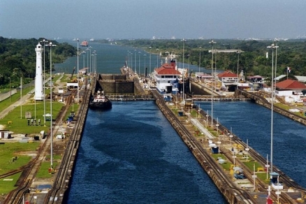
Gatun Locks.on the Panama Canal. Source: Stan Shebs
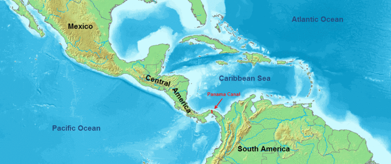
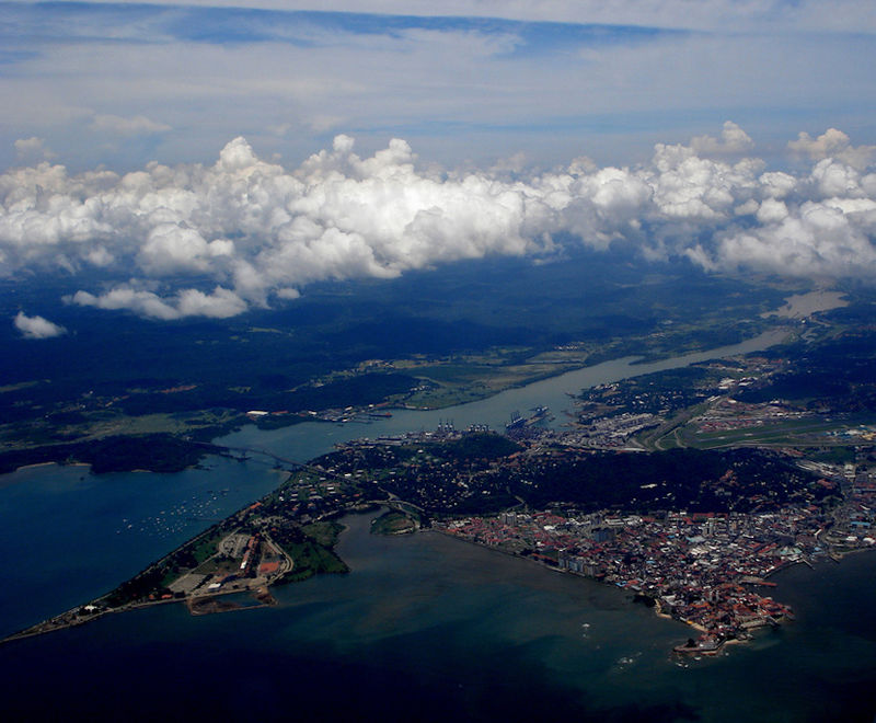
The Panama Canal is a 51 mile (85 km) long man-made waterway for ships connecting the Pacific Ocean with the Caribbean Sea and Atlantic Ocean that cuts across the Isthmus of Panamá from Colon on the north-side, through the man-made Gatun Lake, to Panama City on the south-side.
Closure of the Panama Canal would greatly increase transit times and costs adding over 8000 miles of travel. Vessels moving between the eastern Pacific and western Atlantic would require rerouting around the Straits of Magellan, Cape Horn and Drake Passage below the tip of South America.
The canal, a major artery of international shipping, uses a series of massive locks, manmade lakes, and water supplied by the copious tropical rainfall of the region to lift and lower transiting ships a height of 85 feet over the continental divide.
 Source: DEMIS
Over 14,000 vessels transit the Canal annually, of which more than 60 percent (by tonnage) represent United States coast-to-coast trade, along with United States trade to and from the world that passed through the Panama Canal. The United States is the top country of origin and destination for all commodities transiting through the Panama Canal. While it is not a significant route for U.S. petroleum trade, the canal is an oil transit chokepoint.
The Canal is only 110 feet wide at its narrowest point called Culebra Cut on the Continental Divide.
Completed by the United States in 1914, full control of the canal was transfered to the nation of Panamá on December 31, 1999.
 Source: NASA
Contents
Geography and Structure
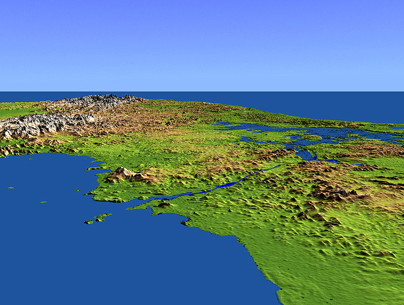
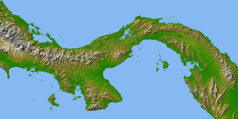
The canal is build across the Isthmus of Panama (sometimes known as the Isthmus of Darien), a narrow strip of land connecting the continents of North and South America. The Isthmus was formed during the late Plioceneera, about 2.8 to 2.5 million years ago when the two continents converged. The Isthmus topology is shown below.
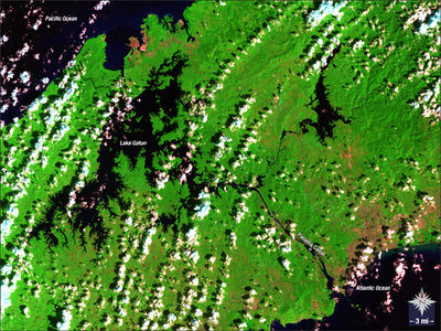
 Scientists made this false-color image of Panama using data acquired in February 2000 by the Shuttle Radar Topography Mission (SRTM), flying aboard the Space Shuttle Endeavor. High-quality satellite imagery of Central America is generally difficult to obtain due to persistent cloud cover in the region. The ability of SRTM to penetrate clouds and make three-dimensional measurements has allowed scientists to produce the first complete high-resolution topographic map of all of Central America. Two visualizations were combined to produce this image of Panama: shading and color coding of topographic height. By computing the topographic slope in the north-south direction, scientists were able to make the shading that gives it its three-dimensional appearance. The colors directly relate to height. Green shows the lowest elevations, just above sea level. Yellows and then tans show progressively higher elevations, with white being the highest. Source: NASA Earth Observatory
Because of the tectonic orgins of the Ithmus, it has a very complicated geology. Much of the land is a result of volcanic activity leading to the existance of several volcanic cores and faults in the canal zone. As seen in the topographic image above, low-lying mountains occur in the region and flank the canal route. Equally challenging to the canal builders were the thick rainforests and swamps the covered the area. A hot (average 80oF) and humid climate,with torrential rains (105 inches/year) made the area very susceptible to many pests and tropical diseases like malaria and yellow fever that killed many who worked on the canal
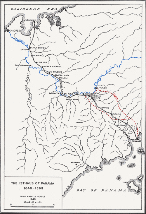 The Chagres River prior to the building of the canal. The black line shows the route of William Henry Aspinwall's railway across the Ithmus which opened in 1855 as an extension of a steam ship service between New York and San Francisco. The path of the Panama Canal was chosen to make maximum use of the geography of the Isthmus; using a route close to its narrowest point, and utilizing existing existing topology and water flows to the greatest extent possible.
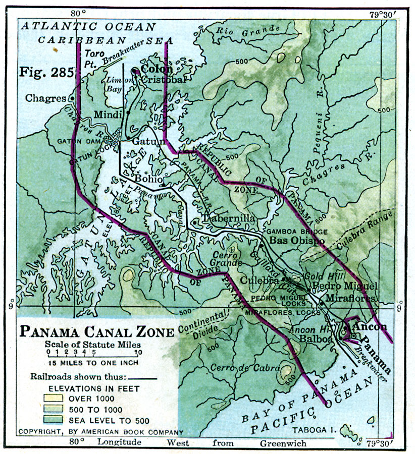
The key watershed is that of the Chagres River which is shown in the map right from the nineteenth century which shows the path of the Chagres River before the modern canal was built.
The Chagres River enters the Carribean Sea (and Atlantic Ocean) west of Limon Bay where the modern canal enters. The city of Colon extends into Limin Bay east of the canal route and includes a major harbor.
The 1913, the Gatun Dam was completed which controlled the flow of the river and flooded its mid-reaches of the Chagres and the streams the fed the river.
Lake Gatun can be thought of as the flooded watershed of the Chagres and the most significant element of the canal on the north (Atlantic) side of the continental divide.
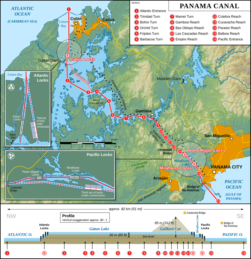
The canal route follows a southward route through Limon Bay and enters Lake Gatun immediately adjacent to Gatun Dam (see the second map.)
Because the height of Gatun Lake is 85 feet (28 metres) above sea level, a series of locks (the Gatun or Atlantic Locks) occurs at the entrace to the lake that allow the level of the ships to be raised. The water in Lake Gatun (from rain and inflows from tributary streams) provides the water necessary for the locks.
The Panama Canal Authority (ACP) notes that "the lock chambers -steps-- are 33.53 meters wide by 304.8 meters long. The maximum dimensions of ships that can transit the Canal are: 32.3 meters in beam; draft -their depth reach- 12 meters in Tropical Fresh Water; and 294.1 meters long (depending on the type of ship)."
At Gamboa, the upper reaches of the Chagres River branches away from Lake Gatun and the canal. A second dam (Madden Dam) on the Chagres creates a second lake (Lake Alajuela) conrols flow from the upper watershed into the Gatun/Canal.
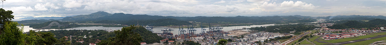
Above Gamboa, the canal continues through a excavated path (Gaillard or Culebra Cut) which is approximately 13.7 km long from Gamboa to the Pedro Miguel Locks. The cut crosses the Contintal Divide which reaches 312 feet (95 m) above sea level at this point.
South of the Contintal Divide the canal descends through a two sets of locks (the Pedro Miguel Locks and the Miraflores Locks, also known as the Pacific Locks) to the Gulf of Panama and Pacific Ocean at the west end of Panama City.
A small lake (Lake Milaflores) occurs between the Pedro Miguel Locks and the Miraflores Locks.
The fixed Bidge of the Americas crosses the canal near its entrance into the Gulf of Panama asnd carries the Trans American Highway.
 Source: Wikimedia Commons
Trade and Taffic
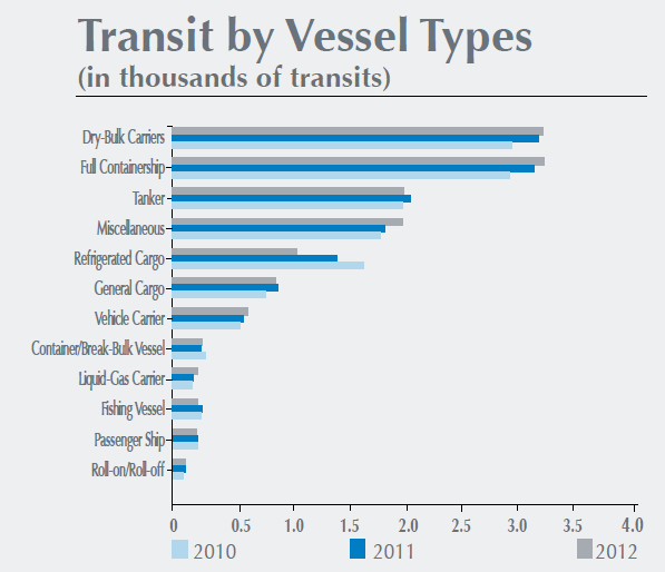 Source: Panama Canal Authority Annual Report 2012 In 2012 14,544 vessels transited through the Canal.
More than 60 percent (by tonnage) represent United States coast-to-coast trade, along with United States trade to and from the world that passed through the Panama Canal.
The United States is the top country of origin and destination for all commodities transiting through the Panama Canal. While it is not a significant route for U.S. petroleum trade, the canal is an oil transit chokepoint.
China is the second most important user of the
Panama Canal. 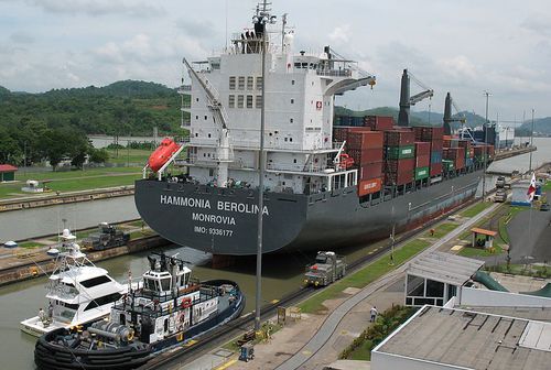 The container ship
Energy
The Panama Canal is not a significant route for petroleum transit or for U. S. petroleum imports.
Roughly one-fifth of the traffic through the canal (measured by both transits and tonnage) was by tankers.
According to the Panama Canal Authority, 755,000 bbl/d of crude and petroleum products were transported through the canal in Fiscal Year 2011, of which 637,000 bbl/d were refined products, and the rest crude oil (EIA conversions from long tons to barrels). Nearly 80 percent of total petroleum, or 608,000 bbl/d, passed from north (Atlantic) to south (Pacific). 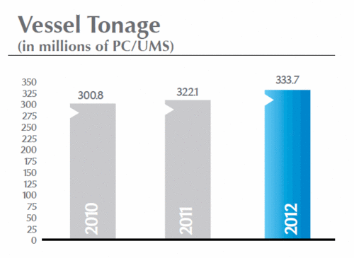 PC/UMS (Panama Canal Universal Measurement System). is based on net tonnage, modified for Panama Canal purposes. PC/UMS is based on a mathematical formula to calculate a vessel's total volume; a PC/UMS net ton is equivalent to 100 cubic feet of capacity. Source: Panama Canal Authority Annual Report 2012
The relevance of the Panama Canal to the global oil trade has diminished, as many modern tankers are too large to travel through the canal. Some oil tankers, such as the ULCC (Ultra Large Crude Carriers) class tankers, can be nearly five times larger than the maximum capacity of the canal. The largest vessel that can transit the Panama Canal is known as a PANAMAX-size vessel (ships ranging from 60,000 â 100,000 dead weight tons in size and no wider than 108 ft.)
In order to make the canal more accessible, the Panama Canal Authority began an expansion program to be completed by the end of 2014. However, while many larger tankers will be able to transit the canal after 2014, some ULCCs will still be unable to make the transit. The Panama Canal Authority features a description of the expansion program and progress reports.
History
Origins
The first idea for a canal is attributed to the Holy Roman Emperor Charles V (1500 - 1558) in 1520, seven years after the Spanish Conquistador Vasco Nuñez de Balboa (1475 - 1518) crossed the Isthmus of Panama from the Atlantic versant to reach the Pacific side.
In 1534, Charles ordered a study of a between the oceans using the Chagres River. The project seemed virtually impossible to carry out at the time.
Throughout the 1800s, American and British leaders and businessmen wanted to ship goods quickly and cheaply between the Atlantic and Pacific coasts, particularly following the California Gold Rush (1949). In 1850 the United States and Great Britain negotiated the Clayton-Bulwer Treaty to reign in rivalry over a proposed canal through the Central American Republic of Nicaragua. President Ulysses S. Grant supported studies by the U.S. Navy of three possible routes in 1869, including through Nicaragua, Panama and Mexico. An Interoceanic Canal Commission (1870-75) backed the route through Nicaragua. The Anglo-American canal, however, never went beyond the planning stages.
In the meantime, American William Henry Aspinwall (1807-1875) opened a railway across the Ithmus (see image above) in 1855 as an extension of a steam ship service between New York and San Francisco. While, it took a day to cross the ithmus, it reduced the travel time between the two cities dramatically.
The French Canal
French attempts to build a canal through Panama (then a province of Colombia) advanced further. Led by Ferdinand de Lesseps—the builder of the Suez Canal in Egypt—the French negotiated a treaty with Colombia (the Wyse Concession, 1878) to build a canal, for which they began excavating in 1880.
De Lesseps backed a "sea level" plan between Colon and Panama City that would not require locks. Avoiding locks did require though a lot more excavating. Ironically, a plan by Baron Godin de Lépinay requiring, just like the completed canal, two dams and locks. One of the dams, on the Chagres, would have created a lake similar to Gatun Lake. Unfortunately for the French enterprise, de Lépinay's plan was rejected until, it was too late to be implemented successfully by them.
As the French project got underway, the dangers of disease immediately beccame apparent.Three months after the work got underway in earnest, the first death of yellow fever occurred. Disease and death was particularly damaging to the canal when it impact leading engineers on the project or their family members.
Plagued by poor planning, insufficient numbers of workers, disease and death, land slides, flash floods induced by rains, insufficient railway and road support, and financial woes, the project moved forward slowly.
The need to switch from a sea level canal to one with locks became increasingly clear. However, de Lesseps opposed a change until late 1887. The new plan, with ten locks was intended to be a temporary solution, with further excavations for a sea level canal carried out using floating dredges carried out after the canal openned. Finally, funding ran out. In May, 1889, after nine years and a loss of approximately 20,000 lives, all activity on the French Panama Canal stopped.
Through the 1890's, there were efforts to revive work on the French effort. Ultimately, the French project, and the work that had been completed to date, was sold to the United States.
Panamanian Independence and 1903 Treaty
Naval operations during the Spanish-American War (1898-1901) served to convince President Theodore Roosevelt that the United States needed to control a canal somewhere in the Western Hemisphere. This interest culminated in the Spooner Bill of June 29, 1902, providing for a canal through the isthmus of Panama, and the Hay-Herrán Treaty of January 22, 1903, under which Colombia gave consent to such a project in the form of a 100-year lease on an area ten kilometers wide. This treaty, however, was not ratified in Bogota, and the United States, determined to construct a canal across the isthmus, intensively encouraged the Panamanian separatist movement.
By July 1903, when the course of internal Colombian opposition to the Hay-Herrán Treaty became obvious, a revolutionary junta had been created in Panama. Jose Augustin Arango, an attorney for the Panama Railroad Company, headed the junta. Manuel Amador Guerrero and Carlos C. Arosemena served on the junta from the start, and five other members, all from prominent Panamanian families, were added. Arango was considered the brains of the revolution, and Amador was the junta's active leader.
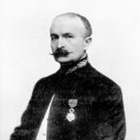 Philippe Bunau-Varilla. Source: U.S. Department With financial assistance arranged by Philippe Bunau-Varilla, a French national representing the interests of de Lesseps's company, the native Panamanian leaders conspired to take advantage of United States interest in a new regime on the isthmus. In October and November 1903, the revolutionary junta, with the protection of United States naval forces, carried out a successful uprising against the Colombian government. Acting, paradoxically, under the Bidlack-Mallarino Treaty of 1846 between the United States and Colombia--which provided that United States forces could intervene in the event of disorder on the isthmus to guarantee Colombian sovereignty and open transit across the isthmus --the United States prevented a Colombian force from moving across the isthmus to Panama City to suppress the insurrection.
President Roosevelt recognized the new Panamanian junta as the de facto government on November 6, 1903; de jure recognition came on November 13. Five days later Bunau-Varilla, as the diplomatic representative of Panama (a role he had purchased through financial assistance to the rebels) concluded the Isthmian Canal Convention with Secretary of State John Hay in Washington. Bunau-Varilla had not lived in Panama for seventeen years before the incident, and he never returned. Nevertheless, while residing in the Waldorf-Astoria Hotel in New York City, he wrote the Panamanian declaration of independence and constitution and designed the Panamanian flag. Isthmian patriots particularly resented the haste with which BunauVarilla concluded the treaty, an effort partially designed to preclude any objections an arriving Panamanian delegation might raise. Nonetheless, the Panamanians, having no apparent alternative, ratified the treaty on December 2, and approval by the United States Senate came on February 23, 1904.
The rights granted to the United States in the so-called Hay-Bunau-Varilla Treaty were extensive. They included a grant "in perpetuity of the use, occupation, and control" of a sixteenkilometer -wide strip of territory and extensions of three nautical miles into the sea from each terminal "for the construction, maintenance, operation, sanitation, and protection" of an isthmian canal.
Furthermore, the United States was entitled to acquire additional areas of land or water necessary for canal operations and held the option of exercising eminent domain in Panama City. Within this territory Washington gained "all the rights, power, and authority . . . which the United States would possess and exercise if it were the sovereign . . . to the entire exclusion" of Panama.
The Republic of Panama became a de facto protectorate of the larger country through two provisions whereby the United States guaranteed the independence of Panama and received in return the right to intervene in Panama's domestic affairs. For the rights it obtained, the United States was to pay the sum of US$10 million and an annuity, beginning 9 years after ratification, of US$250,000 in gold coin. The United States also purchased the rights and properties of the French canal company for US$40 million.
Colombia was the harshest critic of United States policy at the time. A reconciliatory treaty with the United States providing an indemnity of US$25 million was finally concluded between these two countries in 1921. Ironically, however, friction resulting from the events of 1903 was greatest between the United States and Panama. Major disagreements arose concerning the rights granted to the United States by the treaty of 1903 and the Panamanian constitution of 1904. The United States government subsequently interpreted these rights to mean that the United States could exercise complete sovereignty over all matters in the Canal Zone. Panama, although admitting that the clauses were vague and obscure, later held that the original concession of authority related only to the construction, operation, and defense of the canal and that rights and privileges not necessary to these functions had never been relinquished.
Building the Canal
When the United States canal builders arrived in 1904 to begin their momentous task, Panama City and Colon were both small, squalid towns. A single railroad stretched between the towns, running alongside the muddy scars of the abortive French effort. The new builders were haunted by the ghosts of de Lesseps's failure and of the workers, some [22,000] of whom had died on the project. These new builders were able, however, to learn from de Lesseps's mistakes and to build on the foundations of the previous engineering. The most formidable task that the North Americans faced was that of ridding the area of deadly mosquitoes.
After a couple of false starts under a civilian commission, President Roosevelt turned the project over to the United States Army Corps of Engineers, guided by Colonel George Washington Goethals. Colonel William Crawford Gorgas was placed in charge of sanitation. In addition to the major killers--malaria and yellow fever--smallpox, typhoid, dysentery, and intestinal parasites threatened the newcomers.
Because the mosquito carrying yellow fever was found in urban areas, Gorgas concentrated his main efforts on the terminal cities. "Gorgas gangs" dug ditches to drain standing water and sprayed puddles with a film of oil. They screened and fumigated buildings, even invading churches to clean out the fonts of holy water. They installed a pure water supply and a modern system of sewage disposal. Goethals reportedly told Gorgas that every mosquito killed was costing the United States US$10. "I know, Colonel," Gorgas reportedly replied, "but what if one of those ten-dollar mosquitoes were to bite you?"
Gorgas's work is credited with saving at least 71,000 lives and some 40 million days of sickness. The cleaner, safer conditions enabled the canal diggers to attract a labor force. By 1913 approximately 65,000 men were on the payroll. Most were West Indians, although some 12,000 workers were recruited from southern Europe. Five thousand United States citizens filled the administrative, professional, and supervisory jobs. To provide these men with the comforts and amenities to which they were accustomed, a paternalistic community was organized in the Canal Zone.
"According to hospital records, 5,609 died of diseases and accidents during the U.S. construction period. Of these, 4,500 were West Indian workers. A total of 350 white Americans died." (ACP)
The most challenging tasks involved in the actual digging of the canal were cutting through the mountain ridge at Culebra; building a huge dam at Gatun to trap the Rio Chagres and form an artificial lake; and building three double sets of locks--Gatun Locks, Pedro Miguel Locks, and Miraflores Locks--to raise the ships to the lake, almost twenty-six meters above sea level, and then lower them. On August 15, 1914, the first ship made a complete passage through the canal.
"As of July 1, 1914, a total of 238,845,587 cubic yards of material had been excavated during the U.S. construction period. This volume, along with the 30,000,000 cubic yards excavated by the French, totals approximately 268,000,000 cubic yards, more than 4 times the volume originally estimated by Ferdinand de Lesseps for a sea level canal, and 3 times the volume excavated for the Suez Canal.
The disposal of all the excavated material was a very important aspect of the excavation. Nearly hundreds of millions of cubic yards of earth and rock were moved and spread. Part of the material was used to turn an island into a peninsula 3 ¼ miles out on the Pacific Ocean, creating the Naos Island breakwater. Another part of the material was used to create nearly 500 acres along the Pacific Ocean coast to create the town of Balboa and the U.S. military post of Fort Amador. Despite all this, millions of cubic yards of earth were disposed of in the jungle. The largest disposal sites were at Tavernilla, Gatun Dam, Miraflores, and Balboa.
On the afternoon of October 10, 1913, U.S. President Woodrow Wilson pushed a button in Washington, D.C., to blast a dike at Gamboa. The signal, sent by telegraph from Washington to New York, then to Galveston, and from there to Panama, was almost instantaneous. Culebra Cut had almost totally been flooded and became an extension of Gatun Lake." (ACP)
"The total construction cost of the Panama Canal was of approximately US$375,000,000, which included the US$10 million paid to Panama, and US$40 million paid to the French Canal Company for the rights to the Canal. Some authors mention a cost of US$387,000,000, but this amount includes the expense of fortifying the Canal, which is a cost separate from the actual Canal construction."
By the time the canal project was completed, its economic impact had created a new middle class. In addition, new forms of discrimination occurred. Panamanian society had become segregated not only by class but by race and national origin as well. Furthermore, United States commercial competition and political intervention had already begun to generate resentment among Panamanians.
U.S. Control of the Canal
In the very first year of the Hay-Bunau-Varilla Treaty, dissension had already arisen over the sovereignty issue. Acting on an understanding of its rights, the United States had applied special regulations to maritime traffic at the ports of entry to the canal and had established its own customs, tariffs, and postal services in the zone. These measures were opposed by the Panamanian government.
 Panama canal Zone, 1916
Mounting friction finally led Roosevelt to dispatch Secretary of War William Howard Taft to Panama in November 1904. His visit resulted in a compromise agreement, whereby the United States retained control of the ports of Ancon (adjacent to Panama City) and Cristóbal (adjacent to Colon), but their facilities might be used by any ships entering Panama City and Colon. The agreement also involved a reciprocal reduction of tariffs and the free passage of persons and goods from the Canal Zone into the republic. Compromises were reached in other areas, and both sides emerged with most of their grievances blunted if not wholly resolved.
The devaluation of the United States dollar in 1934 reduced its gold content to 59.6 percent of its former value. This meant that the US$250,000 payment was nearly cut in half in the new devalued dollars. As a result, the Panamanian government refused to accept the annuity paid in the new dollars.
Roosevelt's visit to the republic in the summer of 1934 prepared the way for opening negotiations on this and other matters. A Panamanian mission arrived in Washington in November, and discussions on a replacement for the Hay-Bunau-Varilla Treaty continued through 1935. On March 2, 1936, Secretary of State Cordell Hull and Assistant Secretary of State Sumner Welles joined the Panamanian negotiators in signing a new treaty--the Hull-Alfaro Treaty--and three related conventions. The conventions regulated radio communications and provided for the United States to construct a new trans-isthmian highway connecting Panama City and Colon.
The treaty provided a new context for relations between the two countries. It ended the protectorate by abrogating the 1903 treaty guarantee of the republic's independence and the concomitant right of intervention. Thereafter, the United States would substitute negotiation and purchase of land outside the zone for its former rights of expropriation. The dispute over the annuity was resolved by agreeing to fix it at 430,000 balboas (the balboa being equivalent to the devalued dollar) which increased the gold value of the original annuity by US$7,500. This was to be paid retroactively to 1934 when the republic had begun refusing the payments.
The Hull-Alfaro revisions, though hailed by both governments, radically altered the special rights of the United States in the isthmus, and the United States Senate was reluctant to accept the alterations.
Over the ensuing decades resentment among Panamanians over the presence of the United States grew, and was marked by periodic protests and occasional violence.When the National Assembly met in 1947 to consider ratification of a new agreement with the United States concerning bases outside the canal zone, a mob of 10,000 Panamanians armed with stones, machetes, and guns expressed opposition. The upheaval of 1947 was instigated in large measure by university students. Their clash with the National Police on that occasion, in which both students and policemen were killed, marked the beginning of a period of intense animosity between the two groups. The incident was also the first in which United States was met by a massive expression of Panamanian rage.
In May 1958 students demonstrating against the United States clashed with the National Guard. The violence of these riots, in which nine died, was a forecast of the far more serious difficulties that followed a year later. In November 1959 demonstrations occurred during the two Panamanian independence holidays. Aroused by the media, Panamanians began to threaten a "peaceful invasion" of the Canal Zone, to raise the flag of the republic there as tangible evidence of Panama's sovereignty. Fearful that Panamanian mobs might actually force entry into the Canal Zone, the United States called out its troops. Several hundred Panamanians crossed barbed wire restraints and clashed with Canal Zone police and troops. A second wave of Panamanian citizens was repulsed by the National Guard, supported by United States troops.
Public demonstrations and riots arising from popular resentment over the presence of United States citizens and institutions had not been uncommon, but the rioting that occurred in January 1964 was uncommonly serious. The incident began with a symbolic dispute over the flying of the Panamanian flag in the Canal Zone. On January 9, 1964, nearly 200 Panamanian students marched into the Canal Zone with their flag. A struggle ensued, and the Panamanian flag was torn. After that provocation, thousands of Panamanians stormed the border fence. The rioting lasted three days, and resulted in more than 20 deaths, serious injuries to several hundred persons, and more than US$2 million of property damage.
The Canal was one of the central issues in political campaigns with most Panamanian parties denouncing the United States. Political and electoral corruption was widespread, and intervention by the National Gaurd to remove presidents occured periodically.
In the 1970s, about five percent of world trade, by volume, some 20 to 30 ships daily, were passing through the canal. Tolls had been kept artificially low, averaging a little more than US$10,000 for the eight to ten hour passage, and thus entailing a United States government subsidy. Nevertheless, canal use was declining in the 1970s, because of alternate routes, vessels being too large to transit the canal, and the decline in world trade.
The canal, nevertheless, was clearly vital to Panama's economy. Some 30 percent of Panama's foreign trade passed through the canal. About 25 percent of the country's foreign exchange earnings and 13 percent of its GNP were associated with canal activities. The level of traffic and the revenue thereby generated were key factors in the country's economic life.
1977 Treaties
Under the 1903 treaty, the governor of the Canal Zone was appointed by the president of the United States and reported to the secretary of war. The governor also served as president of the Canal Zone Company, and reported to a board of directors appointed by the secretary of war. United States jurisdiction in the zone was complete, and residence was restricted to United States government employees and their families. On the eve of the adoption of new treaties in 1977, residents of the Canal Zone included some 40,000 United States citizens, two-thirds of whom were military personnel and their dependents, and about 7500 Panamanians. The Canal Zone was, in effect, a United States military outpost with its attendant prosperous economy, which stood in contrast to the poverty on the other side of its fences.
By the 1960s military activities in the zone were under the direction of the United States Southern Command (SOUTHCOM). The primary mission of SOUTHCOM was defending the canal. In addition, SOUTHCOM served as the nerve center for a wide range of military activities in Latin America, including communications, training Latin American military personnel, overseeing United States military assistance advisory groups, and conducting joint military exercises with Latin American armed forces.
Negotiations for a new set of treaties were resumed in June 1971, but little was accomplished until March 1973, when, at the urging of Panama, the UN Security Council called a special meeting in Panama City. A resolution calling on the United States to negotiate a "just and equitable" treaty was vetoed by the United States on the grounds that the disposition of the canal was a bilateral matter. Panama had succeeded, however, in dramatizing the issue and gaining international support.
President James E. ("Jimmy") Carter saw returning the Panama Canal as key to improving U.S. relations in the hemisphere and the developing world. Carter held that United States interests would be protected by possessing "an assured capacity or capability" to guarantee that the canal would remain open and neutral after Panama assumed control. This view contrasted with previous United States demands for an ongoing physical military presence and led to the negotiation of two separate treaties. This changed point of view, together with United States willingness to provide a considerable amount of bilateral development aid in addition to the revenues associated with Panama's participation in the operation of the canal, were central to the August 10, 1977 announcement that agreement had been reached on two new treaties. 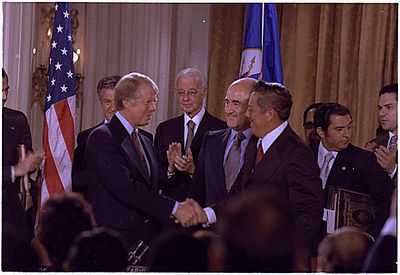 Jimmy Carter and General Omar Torrijos shake hands after signing the Panama Canal Treaty. Source: Carter White House Photographs Collection
On September 7, 1977, Carter and Panamanian Leader General Omar Torrijos met in Washington to sign the treaties in a ceremony that also was attended by representatives of twenty-six other nations of the Western Hemisphere. The Panama Canal Treaty, the major document signed on September 7, abrogated the 1903 treaty and all other previous bilateral agreements concerning the canal.
The treaty was to enter into force six months after the exchange of instruments of ratification and to expire at noon on December 31, 1999. The Panama Canal Company and the Canal Zone government would cease to operate, and Panama would assume complete legal jurisdiction over the former Canal Zone immediately, although the United States would retain jurisdiction over its citizens during a thirty-month transition period. Panama would grant the United States rights to operate, maintain, and manage the canal through a new United States government agency, the Panama Canal Commission. The commission would be supervised by a board of five members from the United States and four from Panama; the ratio was fixed for the duration of the treaty. The commission would have a United States administrator and Panamanian deputy administrator until January 1, 1990, when the nationalities of these two positions would be reversed. Panamanian nationals would constitute a growing number of commission employees in preparation for their assumption of full responsibility in 2000. Another binational body, the Panama Canal Consultative Committee, was created to advise the respective governments on policy matters affecting the canal's operation.
Under the provisions of Article XII, the United States and Panama agreed to study jointly the feasibility of a sea-level canal and, if deemed necessary, to negotiate terms for its construction. Payments to Panama from the commission ("a just and equitable return on the national resources which it has dedicated to the . . . canal") were set forth in Article XIII. These included a fixed annuity of US$10 million, an annual contingency payment of up to US$10 million to be paid out of any commission profits, and US$0.30 per Panama Canal net ton of cargo that passed through the canal, paid out of canal tolls. The latter figure was to be periodically adjusted for inflation and was expected to net Panama between US$40 and US$70 million annually during the life of the treaty. In addition, Article III stipulated that Panama would receive a further US$10 million annually for services (police, fire protection, street cleaning, traffic management, and garbage collection) it would provide in the canal operating areas.
The second treaty, the Treaty Concerning the Permanent Neutrality and Operation of the Panama Canal, or simply the Neutrality Treaty, was a much shorter document. Because it had no fixed termination date, this treaty was the major source of controversy. Under its provisions, the United States and Panama agreed to guarantee the canal's neutrality "in order that both in time of peace and in time of war it shall remain secure and open to peaceful transit by the vessels of all nations on terms of entire equality." In times of war, however, United States and Panamanian warships were entitled to "expeditious" transit of the canal under the provisions of Article VI. A protocol was attached to the Neutrality Treaty, and all nations of the world were invited to subscribe to its provisions.
At the same ceremony in Washington, representatives of the United States and Panama signed a series of fourteen executive agreements associated with the treaties.
Although U.S. opponents of the Treaty returning the Canal to Panama by 2000 criticized Carter’s efforts on the basis of "We Built it, We Paid for it, It's Ours," the Treaties narrowly passed the Senate in April 1978, with various amendments, conditions, understandings, and reservations. Panama and the United States exchanged instruments of ratification for the two treaties on June 16, 1978, and the two treaties entered into force on October 1, 1979.
Some treaty critics have argued that Panama did not accept the amendments, conditions, reservations, and understandings of the U.S. Senate, including the DeConcini condition to the Neutrality Treaty. That condition states: “if the Canal is closed, or its operations are interfered with, the United States of America and the Republic of Panama shall each independently have the right to take such steps as each deems necessary, in accordance with its constitutional processes, including the use of military force in the Republic of Panama, to reopen the Canal or restore the operations of the Canal, as the case may be.” However, others argued that Panama, in fact, had accepted all U.S. Senate amendments. The State Department asserted that Panama expressly accepted all amendments, conditions, and understandings to the two treaties, including the DeConcini condition. The United States and Panama signed the instruments of ratification for both treaties, which incorporated all the Senate provisions. The two countries cooperated throughout the years on matters related to the Canal and established five binational bodies to handle these issues. Two of the bodies were set up to address defense affairs and conducted at least 16 joint military exercises between 1979 and 1985 involving Panamanian and U.S. forces.
Transition to Panamanian Control
The U.S. intervened militarily in Panama on December 20, 1989 to remove General Manuel Antonio Noriega from power after he annulled elections won by Guillermo Endara. Since that time, the country has had five successive civilian governments.
Over the years, U.S. officials consistently affirmed a commitment to follow through with the Panama Canal Treaty and turn the Canal over to Panama at the end of 1999. That transition occurred smoothly on December 31, 1999. The Panama Canal Treaty terminated on that date, and the Panama Canal Commission (PCC), the U.S. agency operating the Canal, was succeeded by the Panama Canal Authority (ACP), a Panamanian government agency established in 1997.
 Pacific Side Entrance of the Panama Canal. In the foreground part of Panama city is visible together with the Bridge of the Americas. In the background (right) Miraflores Locks are also visible. Source: Camilo Molina
Canal Expansion
Since the ACP has run the Canal beginning in 2000, it has been lauded for increasing Canal safety and efficiency. In September 2012, Jorge Luis Quijano was appointed by the ACP’s Board of Directors to become the new Canal Administrator for a seven-year term, succeeding Alberto Alemán Zubieta who had served as Administrator since 1996. Quijano, an engineer, has worked at the Canal since 1975, and led the Canal expansion project beginning in 2006.
In April 2006, the Panama Canal Authority presented to then-President Torrijos its recommendation to build a third channel and new set of locks (one on the Atlantic and one on the Pacific) that would double the capacity of the Canal and allow it to accommodate giant container cargo ships known as post-Panamax ships. The project would also widen and deepen existing channels and elevate Gatun Lake’s maximum operating level. The estimated cost of the seven year project is $5.25 billion, to be self-financed by the ACP through graduated toll increases and external bridge financing of about $2.3 billion that would be paid off in about 10 years.
According to the ACP, the overall objectives of the expansion project are to:
- Achieve long-term sustainability and growth for the Canal’s financial contributions to the Panamanian national treasury;
- Maintain the Canal’s competitiveness;
- Increase the Canal’s capacity to capture the growing world tonnage demand; and
- Make the Canal more productive, safe, and efficient.
Pursuant to Panama’s Constitution (Article 319), the project had to be submitted to a national referendum. The Torrijos government chose to hold the referendum on October 22, 2006, close to the anniversary of October 23, 1977, the date when Panamanians approved the two Panama Canal treaties in a national plebiscite by a two-to-one margin. The expansion project was approved by 78% of the vote, although there was some vocal opposition.
The Panamanian government officially launched the expansion project on September 3, 2007. While the project originally was expected to be completed by 2014, some delays reportedly have pushed the completion to April 2015.
The Canal expansion is expected to reduce shipping rates between Asia and the U.S. Gulf and East coasts, resulting in significant savings and will likely increase Latin American trade with Asia as well as intra-Latin American trade. Many U.S. ports are already readying themselves in order to take advantage of the trade expansion. Some analysts maintain that the Canal expansion, which reportedly will allow 90% of the world’s liquefied natural gas (LNG) tankers to pass through the Canal, will be a boon for the U.S. natural gas industry.66 Others anticipate that the expansion will make U.S. Midwest grain exports more competitive in Asia.
 View of the southern (Pacific) end of the Panama Canal and Bridge of the Americas. Source: Brian Gatwicke
Ecology
 February 5, 1999. Source: NASA GSFC Landsat/LDCM EPO Team Thick rainforests border the canal, and the protected Canal Zone is easily delineated by the dark green band of forest, which contrast the lighter green cultivated areas of Panama.
The ecologically sensitive Canal Zone supports diverse lowland rainforest that is crucial for water balance and erosion/siltation control around the canal. Scientists monitor the edges of the Canal Zone rainforest for degradation from development.
Development of wider channels as part of the Panamax project is causing considerable environmental damage to shorelines and islands in Gatun Lake, including habitat destruction and siltation.
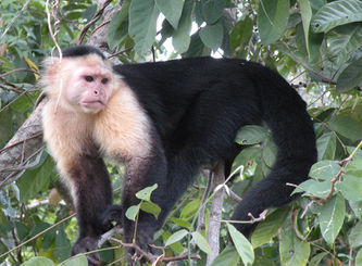 White-face Capuchin in the wild, island in Gatun Lake. @ C. Michael Hogan The canal falls within the Isthmian-Atlantic moist forests ecoregion which covers southern Nicaragua, northern Costa Rica, and a considerable area in (Create a New Article).html Panama (Create a New Article).
This forest ecoregion evolved from unique combinations of North American and South American flora and fauna, which came together with the joining of these continents three million years ago. Currently, much of this ecoregion has been converted to subsistence and commercial agriculture. Islands in the Gatun Lake offer particular biodiversity.
Sources and Further Reading
Geography and Structure
- Panama Canal Authority, The Land at Panama (accessed May 24, 2013)
- NASA Earth Observatory, 2003, Panama: Isthmus that Changed the World
- NASA Earth Observatory, 2003, Panama Canal
- Wikipedia, Panama Canal, (accessed May 24, 2013)
Trade and Taffic
- Energy Information Administration, 2012, World Oil Transit Chokepoints
- Panama Canal Authority,[1] Annual Report 2012 (accessed May 28, 2013)
History
- Panama Canal Authority, History of the Panama Canal (accessed May 24, 2013)
- Meditz, S.W. and Hanratty, D.M., editors. Panama: A Country Study. Washington: GPO for the Library of Congress, 1987.
- Sullivan, M.P., 2012, Panama: Political and Economic Conditions and U.S. Relations, Congressional Research Service
- U.S. Department of State, Building the Panama Canal
- Brodhead, Michael J. 2012. "The Panama Canal: Writings of the U. S. Army Corps of Engineers Officers Who Conceived and Built It." US Army Corps of Engineers History Office, Alexandria, VA
- Cullen, Ben. (2010). The Panama Canal and Me: A Panamax Special. ISBN 978-0-8212-7754-6
- Greene, Julie, The Canal Builders: Making America's Empire at the Panama Canal (New York: Penguin Press, 2009)
- Hoffman, Jon T.; Brodhead, Micheal J; Byerly, Carol R.; Williams, Glenn F. (2009). The Panama Canal: An Army's Enterprise. Washington, D.C.: United States Army Center of Military History. 70–115–1.
- Jorden, William J. (1984). Panama Odyssey. 746 pages, illustrated. Austin: University of Texas Press. ISBN 0-292-76469-3
- Maurer, Noel, and Carlos Yu. The Big Ditch: How America Took, Ran, and Ultimately Gave Away the Panama Canal (Princeton University Press, 2010); 420 pp.ISBN 978-0-691-14738-3.
- McCullough, David. (1977). The Path Between the Seas: The Creation of the Panama Canal, 1870-1914. New York: Simon & Schuster. ISBN 0-671-22563-4
- Mellander, Gustavo A.(1971) The United States in Panamanian Politics: The Intriguing Formative Years. Daville,Ill.:Interstate Publishers. OCLC 138568.
- Mellander, Gustavo A.; Nelly Maldonado Mellander (1999). Charles Edward Magoon: The Panama Years. Río Piedras, Puerto Rico: Editorial Plaza Mayor. ISBN 1-56328-155-4. OCLC 42970390.
- Mills, J. Saxon. (1913). The Panama Canal—A history and description of the enterprise A Project Gutenberg free ebook.
- Parker, Matthew. (2007). Panama Fever: The Epic Story of One of the Greatest Human Achievements of All Time—The Building of the Panama Canal. New York: Doubleday. ISBN 978-0-385-51534-4
Ecology
- NASA Earth Observatory, 2003, Panama Canal
- World Wildlife Fund, Wildfinder