Cape Horn
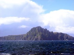 Cape Horn from the South.
Cape Horn (also [Hoorn] and Cabo de Hornos) is the southernmost point of land closely associated with South America; it is located on Isla Hornos in the Hermite Islands group, at the southern end of the Tierra del Fuego archipelago in southern Chile.
Cape Horn is the most southerly of the great capes, and marks the northern boundary of the Drake Passage between South America and Antarctica. For many years it was a major milestone on the clipper route, by which sailing ships carried trade around the world. However, the waters around the cape are particularly hazardous, owing to strong winds, large waves, strong currents and icebergs; these dangers have made it notorious as a sailors' graveyard.
Cape Horn Island was originally given the Dutch name "[Hoorn]", in honor of the Dutch city of Hoorn. It became known in English as "Cape Horn", and in Spanish as "Cabo de Hornos" (which literally means "Cape of Ovens")[1] . It is commonly known to sailors simply as "The Horn"[2] .
The need for ships to round the horn was greatly reduced by the opening of the Panama Canal in 1914. However, sailing around the Horn is widely regarded as one of the major challenges in yachting, and a few recreational sailors continue to sail this route. Several prominent ocean yacht races sail around the world via the Horn, and speed records for round-the-world sailing follow the same route.
Contents
Geography
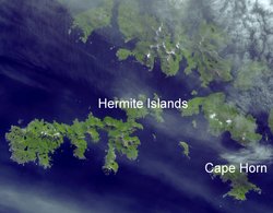 The Hermite Islands (center) and Cape Horn (lower right) as seen from space.
 Cape Horn is the southernmost point of land closely associated with South America; it is located on Isla Hornos in the Hermite Islands group, at the southern end of the Tierra del Fuego archipelago[3] [4] . It marks the north edge of the Drake Passage, the strait between South America and Antarctica. The dividing line between the Atlantic and Pacific oceans runs along the meridian of Cape Horn, from Tierra del Fuego to the Southern Ocean. It is located in Cabo de Hornos National Park[5].
The Cape is a steep headland that rises 424 meters (1391 feet) above the water[6].
The cape lies within Chilean territorial waters and Cape Horn is part of the Commune of Cabo de Hornos, whose capital is Puerto Williams; this in turn is part of Antártica Chilena Province, whose capital is also Puerto Williams. The area is part of the Magallanes y la Antártica Chilena Region of Chile[7] . Puerto Toro, a few miles south of Puerto Williams, is the closest town to the cape, and the southernmost town in the world.
A mile from the Cape, the Chilean Navy maintains a station on Hoorn Island, consisting of a residence, utility building, chapel, and lighthouse[8] . A short distance from the main station is a memorial, including a large sculpture featuring the silhouette of an albatross, in honour of the sailors who died while attempting to "round the Horn"[9] . At the "real" Cape Horn there is a 4 m (13 ft) fiberglass light tower with a focal plane of 40 m (131 ft) and a range of about 21 km (13 mi)), which is the authentic Cape Horn lighthouse.
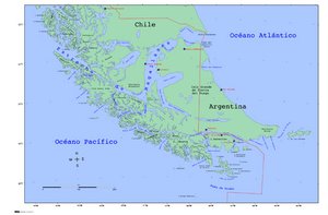 The islands around Cape Horn.
 The terrain is entirely treeless, although quite lush owing to the frequent precipitation.
The climate in the region is generally cool, owing to the southern latitude. The U.S. Navy Climate Atlas of the World (1995) notes:
In winter, gales and precipitation occur up to 30 percent of the time, while seas of 12 feet or more frequent. Sometimes these elements combine to drop visibilities to less that ½ mile. While the Drake passage is a year round storm route, these storms are usually less intense and less frequent during the summer, particularly December, January, and February. During the summer, temperatures reach the upper 40’s (degrees F), skies clear 10 to 15 percent of the time, gales fall off to less than 5 percent, and 12-foot plus seas to less than 15 percent. Precipitation is less frequent, while poor visibilities are uncommon.[10] .
Contemporary weather records for Ushuaia, 146 kilometres (91 mi) north, show that summer (January & February) average temperatures range from highs of 14°C (57°F) to lows of 5°C (42°F); in winter (July), average temperatures range from 4°C (40°F) to minus 2°C (29°F). Cloud cover is generally high, with averages from 5.2 eighths in May and July to 6.4 eighths in December and January[11] . Precipitation is high throughout the year: the weather station on the nearby Diego Ramirez Islands, 109 kilometres (68 mi) south-west in the Drake Passage, shows the greatest rainfall in March, averaging 137.4 millimetres (5.41 in); while October, which has the least rainfall, still averages 93.7 millimetres (3.69 in)[12] .
Visiting Cabo de Hornos can be done on a day trip by helicopter or more arduously by charter power boat or sailboat - or by cruise ship.
History
After Ferdinand Megellan led his ships from the Atlantic to the Pacific through the straits that bears his name in 1520, it was widely believed that the land to the south was connected to a vast southern continent that was believed to exist.
In 1525 the vessel San Lesmes commanded by Francisco de Hoces, member of the Loaísa Expedition, was blown south by a gale in front of the Atlantic end of Magellan Strait and reached 56° S where they thought to see Land's End.
In September 1578, Sir Francis Drake, in the course of his circumnavigation of the world, passed through the Straits of Magellan into the [[Pacific] Ocean]. Before he could continue his voyage north his ships encountered a storm, and were blown well to the south of Tierra del Fuego. The expanse of open water they encountered led Drake to guess that far from being another continent, as previously believed, Tierra del Fuego was an island with open sea to its south. This discovery went unused for some time, as ships continued to use the known passage through the Straits of Magellan[13] .
In 1615, two Dutch ships, the Eendracht and the Hoorn looked for an alternative to the Straits of Magellan and the Cape of Good Hope, the only known routes at the time to the Far East[14]. After the Hoorn was lost, the Eendracht pressed on south of Tierra del Feugo through the Le Maire Strait and on January 25, 1616 found a "the great South Sea, whereat we were exceeding glad to thinke that wee had discovered a way, which untill that time, was unknowne to men, as afterward wee found it to be true.” Four days later, they “saw land againe lying north west and north northwest from us, which was the land that lay South from the straights of Magelan which reacheth Southward, all high hillie lande covered over with snow, ending with a sharpe point which wee called Cape Horne Hoorn ...” [15]
At the time it was discovered, the Horn was believed to be the southernmost point of Tierra del Fuego; the unpredictable violence of weather and sea conditions in the Drake Passage made exploration difficult, and it was only in 1624 that the Horn was discovered to be an island. It is a telling testament to the difficulty of conditions there that Antarctica, only 850 kilometres (500 mi) away across the Drake Passage, was discovered as recently as 1820, despite the passage having been used as a major shipping route for 200 years.
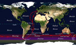 The clipper route followed by ships sailing between England and Australia/New Zealand passed around Cape Horn.
 From the 1700s to the early 1900s, Cape Horn was a part of the clipper routes which carried much of the world's trade[16][17][18] . The Horn exacted a heavy toll from shipping, however, owing to the extremely hazardous combination of conditions there.
The only facilities in the vicinity able to service or supply a ship, or provide medical care, were in the Falkland Islands.
The transcontinental railroads in North America, as well as the Panama Canal in Central America, led to the gradual decrease in use of the Horn for trade. As steamships replaced sailing ships, Pamir became the last commercial sailing ship to round Cape Horn laden with cargo, en route from Port Victoria, Australia to Falmouth, England in 1949.
Many modern tankers are too wide to fit through the Panama Canal, as are a few passenger ships and several aircraft carriers. But there are no regular commercial routes around the Horn, and modern ships are rarely seen.
"Rounding the Horn"
“Rounding the Horn" is traditionally understood to involve sailing from 50 degrees South on one coast to 50 degrees South on the other coast, the two benchmark latitudes of a Horn run[19].
In addition to "Rounding the Horn", there are a number of other sailing routes around the tip of South America, including the Straits of Magellan, the Beagle Channel, and various passages around the Wollaston and Hermite Islands to the north of Cape Horn[20]. However, these are notorious for treacherous williwaw winds, which can strike a vessel with little or no warning[21] . Given the narrowness of these routes, there is a significant risk of then being driven onto the rocks.
The open waters of the Drake Passage, south of Cape Horn, provides a wide route of over 650 kilometers (400 mi) wide with ample sea room for maneuvering as winds change, and is the route used by most ships and sailboats, despite the possibility of extreme wave conditions.
Still several factors combine to make the passage around Cape Horn one of the most hazardous shipping routes in the world: the fierce sailing conditions prevalent in the Southern Ocean generally; the geography of the passage south of the Horn; and the extreme southern latitude of the Horn, at 56° south. (For comparison, Cape Agulhas at the southern tip of Africa is at 35° south; Stewart Island/Rakiura at the south end of New Zealand is 47° south.)
At the latitudes south of Cape Horn, winds can blow from west to east around the world almost uninterrupted by land. These winds are further exacerbated at the Horn by the funneling effect of the Andes and the Antarctic peninsula, which channel the winds into the relatively narrow Drake Passage.
The strong winds of the Southern Ocean give rise to correspondingly large waves; these waves can attain enormous size as they roll around the Southern Ocean, free of any interruption from land. At the Horn, however, these waves encounter an area of shallow water to the south of the Horn, which has the effect of making the waves shorter and steeper, greatly increasing the hazard to ships. If the strong eastward current through the Drake Passage encounters an opposing east wind, this can have the effect of further building up the waves. In addition to these "normal" waves, the area west of the Horn is particularly notorious for rogue waves, which can attain heights of up to 30 metres (100 ft)[22].
The prevailing winds and currents create particular problems for vessels attempting to round the Horn against them, i.e. from east to west. Although this affects all vessels to some extent, it was a particularly serious problem for traditional sailing ships, which could make very little headway against the wind at the best of times; modern sailing boats are significantly more efficient to windward and can more reliably make a westward passage of the Horn.
Ice is also a hazard. Even in summer, the Horn is well below the latitude of the iceberg limit[23].
These hazards have made the Horn notorious as perhaps the most dangerous ship passage in the world; many ships were wrecked, and many sailors died, attempting to round the Cape.
Despite the opening of the Suez and Panama Canals, the Horn remains part of the fastest sailing route around the world, and so the growth in recreational long-distance sailing has brought about a revival of sailing via the Horn. Owing to the remoteness of the location and the hazards there, a rounding of Cape Horn is widely regarded as one of the major challenges in yachting[24][25][26].
The first small boat to sail around Cape Horn was the 42-foot (13 m) yacht Saoirse, sailed by Conor O'Brien with three friends, who rounded it during a circumnavigation of the world between 1923 and 1925[27]. In 1934, the Norwegian Al Hansen was the first to round Cape Horn single-handed from east to west — the "wrong way" — in his boat Mary Jane, but was subsequently wrecked on the coast of Chile. The first person to successfully circumnavigate the world single-handed via Cape Horn was Vito Dumas, who made the voyage in 1942 in his 33-foot (10 m) ketch Lehg II. Today, there are several major yacht races held regularly along the old clipper route via Cape Horn and speed records for round-the-world sailing follow the same route. The Horn remains a major hazard for recreational sailors, however.
Literature and Culture
Cape Horn has been an icon of sailing culture for centuries; it has featured in sea shanties[28] and in many books about sailing. One of the classic accounts of a working ship in the age of sail is Two Years Before the Mast, by Richard Henry Dana, Jr., in which the author describes an arduous trip from Boston to California via Cape Horn:
Just before eight o'clock (then about sundown, in that latitude) the cry of "All hands ahoy!" was sounded down the fore scuttle and the after hatchway, and hurrying upon deck, we found a large black cloud rolling on toward us from the south-west, and blackening the whole heavens. "Here comes Cape Horn!" said the chief mate; and we had hardly time to haul down and clew up, before it was upon us. In a few moments, a heavier sea was raised than I had ever seen before, and as it was directly ahead, the little brig, which was no better than a bathing machine, plunged into it, and all the forward part of her was under water; the sea pouring in through the bow-ports and hawse-hole and over the knightheads, threatening to wash everything overboard. In the lee scuppers it was up to a man's waist. We sprang aloft and double reefed the topsails, and furled all the other sails, and made all snug. But this would not do; the brig was laboring and straining against the head sea, and the gale was growing worse and worse. At the same time sleet and hail were driving with all fury against us. We clewed down, and hauled out the reef-tackles again, and close-reefed the fore-topsail, and furled the main, and hove her to on the starboard tack. Here was an end to our fine prospects.[29]
Charles Darwin, in The Voyage of the Beagle, a journal of the five-year expedition upon which he based The Origin of Species; described his 1832 encounter with the Horn:
... we closed in with the Barnevelts, and running past Cape Deceit with its stony peaks, about three o'clock doubled the weather-beaten Cape Horn. The evening was calm and bright, and we enjoyed a fine view of the surrounding isles. Cape Horn, however, demanded his tribute, and before night sent us a gale of wind directly in our teeth. We stood out to sea, and on the second day again made the land, when we saw on our weather-bow this notorious promontory in its proper form — veiled in a mist, and its dim outline surrounded by a storm of wind and water. Great black clouds were rolling across the heavens, and squalls of rain, with hail, swept by us with such extreme violence, that the Captain determined to run into Wigwam Cove. This is a snug little harbour, not far from Cape Horn; and here, at Christmas-eve, we anchored in smooth water.[29]
Further Reading
- Around Cape Horn: A Maritime Artist/Historian's Account of His 1892 Voyage, Charles G. Davis, Down East Books, 2004. ISBN 0-89272-646-6
- Cape Horn. A Maritime History, Robin Knox-Johnston, Hodder&Stoughton, 1994 ISBN 0-340-41527-4
- Cape Horn: The Story of the Cape Horn Region, Felix Riesenberg and William A. Briesemeister, Ox Bow Press, 1994. ISBN 1-881987-04-3
- Cape Horn and Other Stories From the End of the World, Francisco Coloane. Latin American Literary Review Press, 2003. ISBN 1-891270-17-6
- Gipsy Moth Circles the World, Sir Francis Chichester; International Marine, 1968. ISBN 0-07-136449-8
- Rounding the Horn: Being the Story of Williwaws and Windjammers, Drake, Darwin, Murdered Missionaries and Naked Natives - A Deck's-Eye View of Cape Horn, Dallas Murphy. Basic Books, 2004. ISBN 0-465-04759-9
- En el Mar Austral, by Fray Mocho. University of Buenos Aires Press (La Serie del Siglo y Medio), 1960. ISBN 849687513X
- A World of my Own, Robin Knox-Johnston, Adlard Coles, 2008. ISBN 978-0713668995
- Expediciones españolas al Estrecho de Magallanes y Tierra de fuego, Javier Oyarzun. Madrid: Ediciones Cultura Hispánica ISBN 84-7232-130-4.
- The Last of the Cape Horners. Firsthand Accounts from the Final Days of the Commercial Tall Ships, Spencer Apollonio, Potomac Books, 2001. ISBN 1574884093
- Cape Horn, Tierra Del Fuego, Antarctica and South Georgia -- antique charts of the Cape Horn region
References
Note: This article uses material from the Wikipedia article Cape Horn that was accessed on <<November 26, 2008>>. The Author(s) and Topic Editor(s) associated with this article have significantly modified the derived content with original content and with content drawn from other sources. All content herein has been reviewed and approved by those Author(s) and Topic Editor(s), and is subject to the same Peer review process as other content in the EoE. This article is licensed under the GNU Free Documentation License 1.2. See the EoE Wikipedia Policy for more information
Citation
(2011). Cape Horn. Retrieved from http://editors.eol.org/eoearth/wiki/Cape_Horn- ↑ <a rel="nofollow" title="http://vt.essortment.com/capehorn_ramn.htm" class="external text" href="http://vt.essortment.com/capehorn_ramn.htm">Perilous Cape Horn</a>, by P.J. Gladnick; from eSsortment, 2002. Retrieved February 5, 2006.
- ↑ Rounding the Horn, by Dallas Murphy; Basic Books, 2004. ISBN 0-465-04759-9
- ↑ <a rel="nofollow" title="http://www.nautica.it/charter/capehorn.htm" class="external text" href="http://www.nautica.it/charter/capehorn.htm">Cape Horn the Terrible</a>, by Paolo Venanzangeli; from Nautical Web. Retrieved February 5, 2006.
- ↑ <a rel="nofollow" title="http://www.capehorn-pilot.com/immagini/Charts/10.7%20Cabo%20de%20Hornos.htm" class="external text" href="http://www.capehorn-pilot.com/immagini/Charts/10.7%20Cabo%20de%20Hornos.htm">Cabo de Hornos</a>, by Mariolina Rolfo and Giorgio Ardrizzi. From Patagonia and Tierra del Fuego Nautical Guide, Editrice Incontri Nautici, 2004. ISBN 88-85986-34-
- ↑ <a rel="nofollow" title="http://www.letsgochile.com/locations/Southern-Patagonia/Cape-Horn-Cabo-de-Hornos-National-Park/" class="external text" href="http://www.letsgochile.com/locations/Southern-Patagonia/Cape-Horn-Cabo-de-Hornos-National-Park/">Cape Horn (Cabo de Hornos) National Park</a> retrieved November 26, 2008
- ↑ Columbia Encyclopedia, Sixth Edition, Columbia University Press, 1993
- ↑ <a rel="nofollow" title="http://www.conaf.cl/?page=home/contents&seccion_id=007&unidad=0&articulo_unidad=0&articulo_id=630&maestra=1&PHPSESSID=a13a8b8d0b15efbb59ebc7584bb2ca9a" class="external text" href="http://www.conaf.cl/?page=home/contents&seccion_id=007&unidad=0&articulo_unidad=0&articulo_id=630&maestra=1&PHPSESSID=a13a8b8d0b15efbb59ebc7584bb2ca9a">Cabo de Hornos designado Reserva de la Biósfera</a>, from CONAF. Retrieved February 5, 2006.
- ↑ <a rel="nofollow" title="http://www.lhdigest.com/database/uniquelighthouse.cfm?value=3121" class="external text" href="http://www.lhdigest.com/database/uniquelighthouse.cfm?value=3121">Isla Hornos Lighthouse</a>, from Lighthouse Depot. Retrieved February 5, 2006.
- ↑ <a rel="nofollow" title="http://www.caphorniers.cl/CH_monument.htm" class="external text" href="http://www.caphorniers.cl/CH_monument.htm">Cape Horn Memorial</a>, by Roberto Benavente; from Fundacion Caphorniers Chile. Retrieved February 5, 2006.
- ↑ <a rel="nofollow" title="http://www.seekrieg.com/SouthPacificWeather.pdf" class="external text" href="http://www.seekrieg.com/SouthPacificWeather.pdf">U.S. Navy Marine Climatic Atlas of the World: Rounding Cape Horn</a>, 1995. Retrieved February 5, 2006.
- ↑ <a rel="nofollow" title="http://www.wunderground.com/NORMS/DisplayIntlNORMS.asp?CityCode=87938&Units=both" class="external text" href="http://www.wunderground.com/NORMS/DisplayIntlNORMS.asp?CityCode=87938&Units=both">Ushuaia: Monthly Normals</a> , from Weather Underground. Retrieved February 5, 2006.
- ↑ <a rel="nofollow" title="http://www.wunderground.com/NORMS/DisplayIntlNORMS.asp?CityCode=85972&Units=both" class="external text" href="http://www.wunderground.com/NORMS/DisplayIntlNORMS.asp?CityCode=85972&Units=both">Isla Diego Ramirez: Monthly Normals</a>, from Weather Underground. Retrieved February 5, 2006.
- ↑ <a rel="nofollow" title="http://www.goldenhind.co.uk/education/worksheets/voyage.html" class="external text" href="http://www.goldenhind.co.uk/education/worksheets/voyage.html">Voyage of the Golden Hind</a>, from The Golden Hind. Retrieved February 5, 2006
- ↑ History of Geographical Discovery and Exploration by J.N.L.Baker. London: George G. Harrap & Co., Ltd. 1931, p. 149
- ↑ THE RELATION OF a Wonderfull Voiage made by Willem Cornelison Schouten of Horne. Shewing how South from the Straights of Magelan in Terra Delfuego: he found and discovered a newe passage through the great South Seaes, and that way sayled round about the world. London: Imprinted by T.D. for Nathanaell Newbery, 1619 Of the first edition in English. London: George Rainbird Limited for The World Publishing Company, Cleveland, Ohio, 1966, The Preface. “Translation thereof out of the Dutch, wherein it was written” by William Philip (The Hoorn' was accidentally burned and destroyed on December 19,1615with no loss of life in Patagonia during a bungled cleaning attempt of the hull.)
- ↑ "Along the Clipper Way, Francis Chichester; Hodder & Stoughton, 1966. ISBN 0-340-00191-7
- ↑ <a rel="nofollow" title="http://www.mcallen.lib.tx.us/books/circumna/ci_42cap.htm" class="external text" href="http://www.mcallen.lib.tx.us/books/circumna/ci_42cap.htm">The Circumnavigators</a>, by Don Holm; Around the Three Capes. Prentice-Hall, NY, 1974. ISBN 0131344528 Retrieved February 5, 2006.
- ↑ <a rel="nofollow" title="http://www.caphorniers.cl/ruta_cabo/route.htm" class="external text" href="http://www.caphorniers.cl/ruta_cabo/route.htm">North Americaand the Cape Horn Route</a>, by Captain Harold D. Huycke; from Caphorniers Chile. Retrieved February 5, 2006.
- ↑ The Last Time Around Cape Horn. The Historic 1949 Voyage of the Windjammer Pamir by William F. Stark. New York: Carroll & Graf Publishers. 2003; p. 147 ISBN 0786712333
- ↑ <a rel="nofollow" title="http://yachting.web.cern.ch/yachting/Lectures/Winter/beppe.html" class="external text" href="http://yachting.web.cern.ch/yachting/Lectures/Winter/beppe.html">Sailing the Patagonian channels</a>, from Yachting Club CERN, 2005. Retrieved February 5, 2006.
- ↑ <a rel="nofollow" title="http://www.weatheronline.co.uk/feature/wb241002.htm" class="external text" href="http://www.weatheronline.co.uk/feature/wb241002.htm">Winds of the World: The Williwaw</a>, from Weather Online. Retrieved February 5, 2006.
- ↑ <a rel="nofollow" title="http://www.eu.int/comm/research/rtdinfo/42/article_1308_en.html" class="external text" href="http://www.eu.int/comm/research/rtdinfo/42/article_1308_en.html">Rogue waves</a>, from Europa Research. Retrieved February 5, 2006.
- ↑ Atlas of Pilot Charts: South Pacific Ocean; Lighthouse Press, 2001. ISBN 1-57785-202-8
- ↑ <a rel="nofollow" title="http://www.robduncan.net/capehorn.htm" class="external text" href="http://www.robduncan.net/capehorn.htm">Rob Duncan's Quest for Cape Horn</a>, by Rob Duncan. Retrieved February 5, 2006.
- ↑ <a rel="nofollow" title="http://www.victory-cruises.com/modern_cape_testimony2.html" class="external text" href="http://www.victory-cruises.com/modern_cape_testimony2.html">The Modern CapeHorner</a>, from Victory Expeditions. Retrieved February 5, 2006.
- ↑ <a rel="nofollow" title="http://landlpardey.com/CapeHorn.html" class="external text" href="http://landlpardey.com/CapeHorn.html">Cape Hornto Starboard</a>, from Lin and Larry Pardey. Retrieved February 5, 2006.
- ↑ <a rel="nofollow" title="http://www.mcallen.lib.tx.us/books/circumna/ci_07.htm" class="external text" href="http://www.mcallen.lib.tx.us/books/circumna/ci_07.htm">The Circumnavigators</a>, by Don Holm
- ↑ <a rel="nofollow" title="http://www.bartleby.com/23/5.html" class="external text" href="http://www.bartleby.com/23/5.html">Two Years Before the Mast: A Personal Narrative</a>, by Richard Henry Dana; Chapter V, Cape Horn— A Visit. Signet Classics, 2000. ISBN 0-451-52759-3
- ↑ <a rel="nofollow" title="http://www.literature.org/authors/darwin-charles/the-voyage-of-the-beagle/" class="external text" href="http://www.literature.org/authors/darwin-charles/the-voyage-of-the-beagle/">The Voyage of the Beagle</a>, by Charles Darwin. National Geographic, 2004. ISBN 0-7922-6559-9