Palau
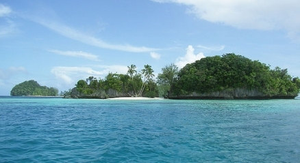
Rock Islands, Palau. Source: Peter Binter/Wikipedia
Countries and Regions of the World Collection  Palau is a group of islands in the North Pacific Ocean, southeast of the Philippines with about 21,000 people. Palau consists of eight principal islands and more than 250 smaller ones lying roughly 500 miles southeast of the Philippines.
Located about 800 kilometers (km) north of the equator, Palau is the westernmost archipelago of Micronesia's Caroline Islands. It consists of six main island groups in a chain approximately 200 km long, and oriented roughly north–south. Babeldaob, or Babelthaup, is the largest (376 km2) island in the chain, and accounts for more than 75 percent of Palau’s land area.
The archipelago of Palau, or Belau, is probably most famous for the Rock Islands (image above), a cluster of more than 200 rounded knobs of karst-weathered, forest-capped limestone, with steep sides plunging to the sea. While its marine environment is spectacular, drawing SCUBA divers from around the world, it also contains Micronesia’s greatest diversity of terrestrial flora and fauna. Its proximity to both New Guinea and the Philippines has caused this small archipelago to support a remarkable variety of endemic birds, plants, reptiles, mammals, and amphibians.

Its major environmental issues include:
- inadequate facilities for disposal of solid waste; and,
- threats to the marine ecosystem from sand and coral dredging; illegal fishing practices, and overfishing
Palau includes the World War II battleground of Beliliou (Peleliu).
After three decades as part of the UN Trust Territory of the Pacific under US administration, Palau opted for independence in 1978 rather than join the Federated States of Micronesia. A Compact of Free Association with the US was approved in 1986 but not ratified until 1993. It entered into force the following year when the islands gained independence.
Palau is in continuing maritime delineation negotiations with the Philippines and Indonesia.
Contents
Geography
Location: Oceania, group of islands in the North Pacific Ocean, southeast of the Philippines
Geographic Coordinates: 7 30 N, 134 30 E
Area: 459 sq km
Coastline: 1,519 km
Maritime Claims:
Natural Hazards: typhoons (June to December)
Terrain: varying geologically from the high, mountainous main island of Babelthuap to low, coral islands usually fringed by large barrier reefs. The highest point is Mount Ngerchelchuus (242 m).
Climate: tropical; hot and humid; wet season May to November.
Palau’s climate is tropical, with a hot, humid rainy season that extends from May through November. It lies outside the main typhoon path; nevertheless, during the typhoon season of June through December, it is hit by occasional storms with high winds that damage trees and buildings. The mean annual temperature in the capital city of Koror is 27ºC, and the mean annual rainfall is about 3,730 millimeters (mm). Rainfall varies little from month to month, although February, March, and April tend to be slightly drier.
Geologically, the main islands of Palau can be divided into two distinct domains:
(1) the deeply weathered and leached volcanic areas of Babeldaob, parts of the island of Koror, and a few small nearby islands; and
(2) the more recent, often karst-weathered, limestone of the southern islands.
Because of differences in topography, drainage, soils, and soil chemistry, there are distinct differences in the vegetation communities between volcanic and limestone islands. There are also a number of outlying atolls, including Kayangel in the North and Helen and Tobi in the South.
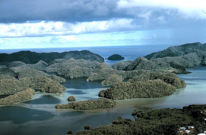
Aerial view of uplifted limestone islands in Palau . Ca. 1971. Photographer: Dr. James P. McVey, NOAA Sea Grant Program. Source: NOAA.
Ecology and Biodiversity
Ecologically, Palau is within the Palau tropical moist forests ecoregion.
Dense tropical broadleaf forests cover most of the volcanic and all of the limestone islands, with the exception of Babeldaob, where large areas have been cleared and replaced by grassland. The tropical moist forests of Palau can be divided into 8 main types: upland forest (found only on the high volcanic islands), swamp forest, mangrove forest, atoll forest, casuarina forest, limestone forest (with a subtype in the Rock Islands), plantation forest, and palm forest.
The upland forests of Palau are the most species diverse in Micronesia and contain several endemic species. There are six native palm species, generally found in the understory or middle canopy layers of the forest. Campnosperma brevipetiolata is one of most common canopy trees in the upland forest. It is generally found at lower elevations (less than 150 meters) on flat or gently sloping sites, and in riparian areas. Other major species include Parinari corymbosa, Alphitonia carolinensis, Rhus taitensis, Elaeocarpus carolinensis, Serianthes kanehirae, Semecarpus venenosus, Calophyllum inophyllum, Gmelina palawensis, and Pterocarpus indicus. Common understory species include Pandanus aimiriikensis, Ixora casei, Eugenia cuminii, Osmoxylon oliveri, Manilkara udoido, Symplocos racemosa, and Cyathea lunulata.
Swamp forests are found in low-lying areas, just inland of mangroves and above tidal influence. These forests are generally quite disturbed, having been used extensively for taro cultivation. In the few somewhat natural areas of swamp forest remaining, such as those found on Peleliu, common species include Barringtonia racemosa and Terminalia catappa. Derris trifoliata is a common climbing vine found on trees in the swamp forest, and Hibiscus tiliaceus is often found in disturbed areas.
Mangrove forests occur along the lower portions of rivers, on coastal mudflats, and on some offshore islets. Well-developed stands may be 15 to 20 meters in height. The dominant species in Palau’s mangrove forests are Rhizophora spp., but some Bruguiera gymnorrhiza are also found. On the seaward side of the forest, Sonneratia alba and Rhizophora mucronata are dominant.
Because of agroforestry, little remains of the native atoll forests, except on uninhabited atolls. Atoll forests are found toward the interior of the larger, wetter uninhabited atolls and along coasts of the high islands. They are generally located behind the strand zone, but may be mixed with strand vegetation. They usually have an outer shrubby fringe of Scaevola taccada. Small, well-formed Pemphis acidula are common on rocky coasts, and tall Casuarina litorea trees are often found on leeward coasts.
Limestone forest is found on the coral islands of Peleliu, Angaur, and the Rock Islands. The species composition varies from island to island, and various endemic species are present. The habitat of all limestone forests is similar; humus from decaying vegetation provides a sustained cycling of nutrients. Common species include Intsia bijuga, Psychotria spp., and Clerodendrum inerme. This forest type once covered much of Peleliu, but much of it was destroyed or degraded during World War II. However, it is still fairly common in patches throughout the islands.
The Rock Island forest is a subtype of limestone forest that is extremely diverse in species composition. (The Rock Islands are a cluster of extremely steep karst-weathered limestone islands that extend from Koror Island south toward the island of Peleliu.) Some of more common species in this forest are endemic palms such as Gulubia palauensis and Ptychosperma palauensis, and forest trees such as Semecarpus venenosus, Premna obtusifolia, Cordia spp., and Bikkia palauensis. Pandanus spp. and Dracaena multiflora are common understory plants.
Biodiversity Features
Palau is floristically much richer than the rest of the Carolines, with the exception of Yap. Together, Yap and Palau form a distinct phytogeographic unit. The easternmost extension of several species from Indo-Malesian flora are found here, including members of the genera Gmelina, Gulubia, Parinari, and Pterocarpus.
Ten bird species are restricted to Palau, and none of these are threatened. These include two doves, an owl, a swiftlet, and six passerines. In total 16 restricted-range species are found in Palau, and one of these, the Micronesian scrubfowl (Megapodius laperouse) is considered endangered. The endangered Japanese night-heron (Gorsachius goisagi), while not endemic or with a restricted range is also present in Palau.
Terrestrial mammals are restricted to two extant bat species: the relatively common Palau flying-fox (Pteropus pelewensis), and the rare insectivorous sheath-tailed bat (Emballonura semicaudata palauensis). The sheathtail bat is considered endangered while another species, the large Palau flying-fox (Pteropus pilosus) is presumed to be extinct.
One ranid frog, six gekkos, three skinks, and one wormsnake are endemic to Palau. The saltwater crocodile (Crocodylus porosus), while a lower risk species globally, is at the edge of its range in Palau and is under threat from habitat destruction and hunting.
Terrestrial invertebrates are poorly known, but include at least 11 arachnid families.
Current Status
Originally, Palau was probably almost completely forested; today, forest cover is only about 75 percent. Most of the remaining land is grassland, agroforest, or secondary vegetation. Under Japanese administration during World War II, large areas of southern Babeldaub were cleared for pineapple and sugar plantations. The endemic palm Gulubia palauensis is also threatened by the feeding of an introduced cockatoo, which escaped from Oreor. In general, thanks in part to relatively low population density, much of Palau’s environment is in good condition.
Types and Severity of Threats
Loss of habitat due to development is affecting some birds, especially on Koror and Babeldaob. Guns are now outlawed, and many species of birds are protected by local laws. A growing human population and an increased push for tourism could have serious negative impacts on the environment if not carefully planned and managed.
See also:
People and Society
Population: 21,032 (July 2012 est.)
About 64% of Palauans live in Koror State's capital city, Koror. (Note: Government offices are located in a new National Capitol Building complex located at Ngerulmud, Melekeok State.)
Ethnic Groups: Palauan (Micronesian with Malayan and Melanesian admixtures) 69.9%, Filipino 15.3%, Chinese 4.9%, other Asian 2.4%, white 1.9%, Carolinian 1.4%, other Micronesian 1.1%, other or unspecified 3.2% (2000 census)
Age Structure:
0-14 years: 21.5% (male 2,329/female 2,187)
15-64 years: 72% (male 8,355/female 6,724)
65 years and over: 6.5% (male 402/female 959) (2011 est.)
Population Growth Rate: 0.361% (2012 est.)
Birthrate: 10.79 births/1,000 population (2012 est.)
Death Rate: 7.89 deaths/1,000 population (July 2012 est.)
Net Migration Rate: 0.71 migrant(s)/1,000 population (2012 est.)
Life Expectancy at Birth: 72.06 years
male: 68.9 years
female: 75.4 years (2012 est.)
Total Fertility Rate: 1.72 children born/woman (2012 est.)
Languages: Palauan (official on most islands) 64.7%, Filipino 13.5%, English 9.4%, Chinese 5.7%, Carolinian 1.5%, Japanese 1.5%, other Asian 2.3%, other languages 1.5% (2000 census). Note: Sonsoral (Sonsoralese and English are official), Tobi (Tobi and English are official), and Angaur (Angaur, Japanese, and English are official)
Literacy (age 15 and over can read and write): 90% (1980 est.)
Urbanization: 83% of total population (2010) growing at an annual rate of change of 1.4% (2010-15 est.)
Access to improved drinking water sources: 83% of population
Access to improved sanitation facilities: 80% of population
History
Palau was initially settled more than 4,000 years ago, probably by migrants from what today is Indonesia. British traders became prominent visitors in the 18th century, followed by expanding Spanish influence in the 19th century. Following its defeat in the Spanish-American War, Spain sold Palau and most of the rest of the Caroline Islands to Germany in 1899. Control passed to Japan in 1914 and then to the United States under United Nations auspices in 1947 as part of the Trust Territory of the Pacific Islands.
Four of the Trust Territory districts formed a single federated Micronesian state in 1979, but this eventually dissolved as the individual districts--long culturally distinct--opted for more locally popular status. Palau approved a new constitution in 1981, subsequently signing a Compact of Free Association with the United States in 1982. After eight referenda and an amendment to the Palauan constitution, the Compact went into effect on October 1, 1994, marking Palau's emergence from trusteeship to independence.
Government
Government Type: constitutional government in free association with the US; the Compact of Free Association entered into force on 1 October 1994
Palau is a democratic republic with directly elected executive and legislative branches. Presidential elections take place every 4 years, at the same time as the United States' presidential election, to select the president and the vice president, who now run as a team. The Palau National Congress (Olbiil era Kelulau) has two houses. The Senate has 13 members elected nationwide. The House of Delegates has 16 members, one each from Palau's 16 states. All of the legislators serve 4-year terms. Each state also elects its own governor and legislature.
The Council of Chiefs, comprising the highest traditional chiefs from each of the 16 states, is an advisory body to the president. The Council is consulted on matters concerning traditional laws and customs.
In November 2008 Palauans elected a new president and vice president: Johnson Toribiong and Kerai Mariur. They took office on January 15, 2009. The same elections brought sweeping change to the legislature and passed more than 20 amendments to the constitution.
Capital: Melekeok
Administrative divisions: 16 states; Aimeliik, Airai, Angaur, Hatohobei, Kayangel, Koror, Melekeok, Ngaraard, Ngarchelong, Ngardmau, Ngatpang, Ngchesar, Ngeremlengui, Ngiwal, Peleliu, Sonsorol
Independence Date: 1 October 1994 (from the US-administered UN trusteeship)
Legal System: mixed legal system of civil, common, and customary law. Palau has not submitted an International Court of Justice (ICJ) jurisdiction declaration; and is a non-party state to the International criminal court (ICCt).
The judicial system consists of the Supreme Court--with trial and appellate divisions--the Court of Common Pleas, and the Land Court. (Palau's constitution has a provision for an additional National Court, but this is not currently active.)
International Environmental Agreements
Palau is party to international agreements on: Biodiversity, Climate Change, Climate Change-Kyoto Protocol, Desertification, Law of the Sea, Ozone Layer Protection, Wetlands, and Whaling.
Resources
Natural Resources: forests, minerals (especially gold), marine products, deep-seabed minerals
Land Use:
Economy
Palau is one of the wealthier Pacific Island states. Nominal GDP increased by an annual average of nearly 14% from 1983 to 1990, and by an annual rate of over 10% from 1991 to 1997. The population enjoys a per capita income roughly 50% higher than that of the Philippines and much of Micronesia. Growth turned sharply negative in 1998 and 1999 as a result of the Asian financial crisis, but a gradual rebound followed, and the economy grew by 5.6% in 2007.
Tourism (and its attendant infrastructure changes) is Palau's main industry. Its major draws are its diverse and pristine marine environment, and its above-water tropical island beauty. The number of visitors--31% from Japan, 35% from Taiwan, 17% from Korea, and 8% from the U.S.--was over 100,000 in 2011, a 13% increase from 2010. Continental Airlines has direct flights to Palau from Guam and the Philippines. Delta Airlines has weekly non-stop flights from Narita, Japan to Palau. Japan Airlines runs chartered flights from Tokyo, and Korean Airlines does the same from Seoul on a seasonal basis. Long-run prospects for the key tourist sector have been greatly bolstered by the expansion of air travel in the Pacific, the rising prosperity of leading East Asian countries, and the willingness of foreigners to finance infrastructure development.
Palauan tourism and environmental authorities would like to adjust the industry, simultaneously decreasing tourist volume and increasing income by attracting more high-dollar tourists. Business and tourist arrivals numbered 85,000 in 2007.
The service sector dominates the Palauan economy, contributing more than 50% of GDP and employing more than half of the work force. The government alone employs about 30% of workers and accounts for 20% of the GDP.
Construction is an important industrial activity, contributing over 15% of GDP. Several large infrastructure projects, roads, and hotels have boosted this sector's recent contribution to GDP.
Agriculture is mainly on a subsistence level, the principal crops being coconuts, taro, and bananas. Fishing is a potential source of revenue, but the islands' tuna output dropped by over one-third during the 1990s. Fishing industry revenues are mostly from license fees from fishing vessels.
One of the government's main responsibilities is administering external assistance, and the main economic challenge confronting Palau is to ensure the long-term viability of its economy by reducing its reliance on foreign assistance.
Under the terms of the Compact of Free Association with the United States, Palau received more than $800 million in direct assistance over 15 years and exercised its prerogative to participate in a wide range of federal programs. In early September 2010, the United States and Palau concluded a 15-year comprehensive review of the Compact. A wide range of federal programs will continue for the next 15 years. By the end of 2010, the value of a trust fund set up under the Compact was approximately $160 million.
The government is the major employer of the work force relying heavily on financial assistance from the US. The Compact of Free Association with the US, entered into after the end of the UN trusteeship on 1 October 1994, provided Palau with up to $700 million in US aid for the following 15 years in return for furnishing military facilities.
GDP: (Purchasing Power Parity): $164 million (2008 est.)
GDP: (Official Exchange Rate): $164 million (2008)
GDP- per capita (PPP): $8,100 (2008 est.)
GDP- composition by sector:
Agricultural products: coconuts, copra, cassava (tapioca), sweet potatoes; fish
Industries: tourism, craft items (from shell, wood, pearls), construction, garment making
Currency: US dollar