Ozark Mountain forests
ContentsWWF Terrestrial Ecoregions Collection |
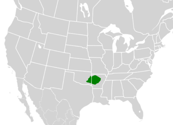
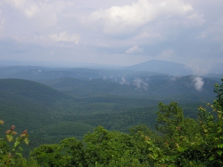
The Ozark Mountain forests are comprised chiefly of the Ouachita and Boston Mountains, whose forests are among the best developed oak-hickory forests in the United States.
The primary species here are red oak (Quercus rubra), white oak (Q. alba), and hickory (Carya spp, especially Carya texana). Shortleaf pine (Pinus echinata) and eastern red cedar (Juniperus virginiana) are important on disturbed sites, shallow soils, and south- and west-facing slopes.
 Source: Wikimedia Commons The Ouachita Mountains cover an area approximately 380 kilometers (km) east to west by 100 km north to south in western Arkansas and southeastern Oklahoma.
The region has ridge and valleytopography, and erosion has been the dominant geological force for the last 300 million years. Maximum average annual precipitation in the Ouachita Mountains is over 150 centimeters per year (cm/yr), and minimum average annual precipitation is less than 100 cm/yr.
This ecoregion includes significant old growth forest. Thousands of acres of stunted oaks on dry sites over 760 meters (m) (2,500 feet) elevation in western Arkansas’s Ouachita National Forest have never been cut. There is an abundance of acreage in cover types of pine/mixed, pine/hardwood, and hardwood 70 years of age and older, with relatively small amounts of forest over 100 years old. In the Boston Mountains, scattered old growth may total 181 square kilometers (km2).
Biological distinctiveness
This ecoregion contains distinctive freshwater communities. The Ouachita and Boston Mountains also were minor Pleistocene refugia. The ecoregion is also home to an endemic earthworm, Diplocardia meansi. Restricted to the drier soils of Rich Mountain, this worm is the second largest known earthworm in the United States and is bioluminescent. When tweaked or shocked the worm secretes a fluid that glows in the dark.
Conservation status
Habitat loss
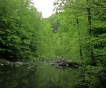
 Richland Creek, Arkansas, USA. (Photograph by Wayne Angel) Only about three percent of this ecoregion remains as intact habitat. While the upper elevation forests are still in relatively good condition, riparian habitat has been severely degraded. The forests along the Arkansas River, for example, have been almost completely destroyed. Conversion to agriculture, logging, fire suppression, and grazing are the main causes of habitat loss.
Remaining blocks of habitat
The Boston Mountains and Oauchita Mountains themselves are the only remaining large and intact habitat blocks in this ecoregion. There are no significant blocks of intact lowland habitats, due to historic habitat fragmentation, and even the blocks on the Ouachita Mountains are broad and somewhat diffuse.
Degree of fragmentation
Habitats in this ecoregion have been badly fragmented. There is some degree of connectivity within the habitat blocks, but little between the blocks. Degraded corridors within the two major habitat blocks (see above) may be restorable, but such is not the case elsewhere in the ecoregion. Similarly, ecosystem dynamics remain intact within the major habitat blocks but not outside them.
Degree of protection
The Boston and Ouachita Mountains are the only adequately protected areas in this ecoregion.
Types and severity of threats
Conversion of hardwood to pine forests and the construction of second homes and resorts pose the greatest conversion threat to this ecoregion. Fire suppression is a major cause of degradation. Wildlife exploitation in the form of bear poaching and herb extraction is also a significant concern.
Suite of priority activities to enhance biodiversity conservation
- The most important areas in this ecoregion are under public ownership. Improved biodiversity management of these areas is needed.
- Identification and conservation of important biodiversity areas should be a priority.
- Continue major ecosystem restoration effort in Ouachita National Forest.
- Complete a land exchange between Weyerhaeuser and the U.S. Forest Service.
- Important old growth sites include:
- Blackfork Mountain
- Clifty Canyons Special Interest Area (6.69 km2)
- Turkey Mountain and adjacent slopes (4.04 km2 of apparently unlogged post oak and chinquapin oak savanna)
- Cossatot River State National Park Natural Area (up to 8.09 km2 of old growth eastern red cedar glades and xeric pine or pine-hardwood forest on steep slopes)
- Cucumber Creek Watershed (72.85 km2). The Oklahoma Nature Conservancy owns 6.07 km2 of this watershed, which includes some large shortleaf pine on the steeper slopes that are 51 to 76 cm in diameter and blackgum and hickory that may be up to 91 cm in diameter. Large sycamore trees occur along the stream. The upper part of the watershed has probably not been cut since the turn of the century.
Conservation partners
- Arkansas Natural Heritage Commission
- Mountain County Wildlife Association
- The Nature Conservancy
- The Nature Conservancy - Southeast Regional Office
- Oklahoma Natural Heritage Inventory
- The Ozark Society
Relationship to Other Classification Schemes
Omernik creates separate [[ecoregion]s] for the Boston and Ouachita Mountains, primarily on the basis of elevation. Bailey also has separate classifications for this region, placing the Boston Mountains in the Ozark Broadleaf Forest-Meadow Province and the rest of the region in the Eastern Broadleaf Forest (Continental) Province. We believe the similarities of ecological processes and communities justify placing the Boston and Ouachita Mountains in a single ecoregion. Those processes and communities also distinguish this region from the rest of the Ozarks and surrounding forest types.
Additional information on this ecoregion
- For a shorter summary of this entry, see the WWF WildWorld profile of this ecoregion.
- To see the species that live in this ecoregion, including images and threat levels, see the WWF Wildfinder description of this ecoregion.
- World Wildlife Fund Homepage
| Disclaimer: This article contains information that was originally published by the World Wildlife Fund. Topic editors and authors for the Encyclopedia of Earth have edited its content and added new information. The use of information from the World Wildlife Fund should not be construed as support for or endorsement by that organization for any new information added by EoE personnel, or for any editing of the original content. |

