Offshore Drilling in the Arctic: Background and Issues for the Future Consideration of Oil and Gas Activities
Contents
- 1 Offshore drilling in the Arctic: background and issues for the future consideration of oil and gas activities
- 1.1 Oil and Gas Development in Alaska and the Arctic
- 1.2 The Economics of Oil in Alaska
- 1.3 Challenges of Oil Spill Response in the Arcticx
- 1.4 Alaskan Native Subsistence Resource Issues in the Arctic
- 1.5 Arctic Ecological Resources
- 1.6 Filling Scientific Data and Oil Spill Response Research Gaps in the Arctic
- 1.7 Summary and Findings
- 1.8 End Notes
Offshore drilling in the Arctic: background and issues for the future consideration of oil and gas activities
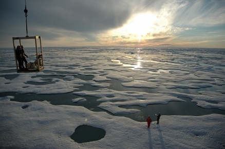
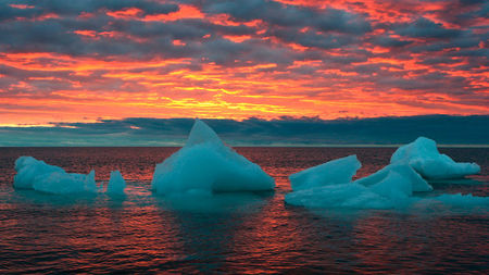
Ice and open water in the Beaufort Sea north of Alaska. Credit: NOAA
Editor's Note: This article is excerpted directly from National Commission on the BP Deepwater Horizon Oil Spill and Offshore Drilling, "Offshore Drilling in the Arctic: Background and Issues for the Future Consideration of Oil and Gas Activities," Staff Working Paper No. 13. It has been edited only to conform to the Encyclopedia's style guidelines.
This working paper synthesizes staff research and provides an overview of many issues relevant to offshore oil and gas development in the Arctic.i Topics covered by the paper include a brief historical background of Arctic oil and gas development, a discussion of the economic importance of oil in Alaska, challenges of Arctic oil spill response, Arctic subsistence resource issues, an overview of important ecological resources in the Arctic, and data gaps relevant to future oil and gas decision-making. The paper concludes with a summary of staff findings relevant to the future of offshore oil and gas development in the Arctic.
 The thawing of Arctic Ocean ice during summer months will lead to increased maritime transportation, tourism, and oil exploration activity. Credit: NOAA The thawing of Arctic Ocean ice during summer months will lead to increased maritime transportation, tourism, and oil exploration activity. Credit: NOAA
|
Oil and Gas Development in Alaska and the Arctic
The Beginnings of Oil and Gas Development in Alaska
 Arctic Platform. Credit: Anadarko Petroleum Corp. Arctic Platform. Credit: Anadarko Petroleum Corp.
|
In 1867, when U.S. Secretary of State William Seward purchased Alaska from the Russian Empire, the United States gained over 586,000 square miles of territory for less than 2¢ per acre.1 At the time, some Americans referred to the area as ‘Seward’s Icebox’ and viewed it as too expensive, too far away, and lacking in valuable resources. Those beliefs changed two years later when massive gold deposits were found in the Klondike. The recognized value of Alaska’s economic, ecological, and cultural resources to the United States has continued to increase ever since.
Although the early Russians noted land-based oil seepages during their 125-year occupation of Alaska, they did not make any attempts to explore or develop the finds; similarly, the Americans did not conduct any petroleum exploration or development in the early years following the 1867 purchase.2 The first Alaskan wells were drilled in 1898 on the Iniskin Peninsula, but they were not particularly successful. However, by 1911, significant amounts of oil were being produced at Katalla on the Gulf of Alaska (Gulf of Alaska large marine ecosystem).3 This production not only demonstrated the feasibility, but also the high cost of producing and transporting [[Alaska]n oil]. The first major commercial discoveries in Alaska followed in 1957 at the Swanson River oil field on the Kenai Peninsula and at Middle Ground Shoal oil field in Cook Inlet in 1962.4
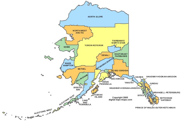
In 1968, America’s largest oil field was discovered on state land at Prudhoe Bay, along the Alaska North Slope (see Figure 1 below for the location of the North Slope).ii This discovery was initially estimated at 9.6 billion barrels of oil,iii which was nearly double the size of the largest field known to exist in North America at that time.5 With this discovery, large amounts of money began to flow into Alaska through construction of the Trans-Alaska Pipeline (began in 1974), and production in the [[Prudhoe Bay] field] (began in 1977).6
|
|
Exploration and Development in the Beaufort Sea
While development and production on the North Slope increased, Arctic nearshore and offshore areas in the Beaufort and Chukchi Seas were also being considered for development. In 1979, the Department of the Interior conducted a lease sale that included portions of state and federal waters of the [[Beaufort] Sea]. This sale led to the first major venture into Arctic offshore exploration for oil and gas.7 Drilling in the Beaufort began in 1981 – a total of 20 wells were drilled by 1989, and an additional ten wells were drilled between 1990 and 2003. Most of the early wells drilled in the Beaufort were non-producible, iv with only a few being further developed. Since the 1979 lease sale, an additional nine lease sales have occurred in the Beaufort Sea Outer Continental Shelf Planning Area – three each decade between the 1980s and 2010. The 2003, 2005, and 2007 sales had a combined total of almost $98 million in high bids.8 Figure 2 (below) depicts the current lease ownership in the [[Beaufort] Sea].
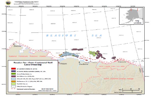 Figure 2: Map of the Bureau of Ocean Energy Management, Regulation, and Enforcement (BOEMRE)(v) Beaufort Sea Outer Continental Shelf Planning Area. This map depicts current lease ownership in the Beaufort Sea by company. Map from BOEMRE. Figure 2: Map of the Bureau of Ocean Energy Management, Regulation, and Enforcement (BOEMRE)(v) Beaufort Sea Outer Continental Shelf Planning Area. This map depicts current lease ownership in the Beaufort Sea by company. Map from BOEMRE.
|
The nearshore fields in the [[Beaufort] Sea] (located within approximately 10 miles of the shoreline) are either fully or partially based on artificial offshore islands.9 Artificial gravel islands have been historically used for oil and gas production in areas of the Beaufort that are close to shore and shallow – they are less expensive to design and construct than ice-capable platforms, and they are able to withstand surging ice. Future wells proposed further offshore in the [[Beaufort] Sea] are expected to use floating drilling rigs, similar to those used in the Gulf of Mexico (United States experience in the deepwater Gulf of Mexico), for exploratory drilling.10,vi Operation of the associated offshore production wells is expected to be conducted from fixed year-round structures constructed to withstand the forces of sea ice.
BP is operating two nearshore fields in the [[Beaufort] Sea]: Endicott and Northstar, both of which are currently producing. They also have development plans at a site called Liberty. All three of the BP sites are or will be constructed on man-made gravel islands. Figure 3 (below) shows a map of the North Slope that includes all three of the BP sites.
|
|
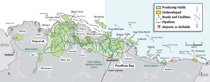
Endicott is located about eight miles east of Prudhoe Bay in 14 feet of water. ExxonMobil is a co-venturer in the field with BP. Production from the field began in 1987 – it was the first producer in the [[Beaufort] Sea] (nearshore or offshore).11 Endicott was built as a self-contained community with production and living facilities, including a power generation facility, a desalination plant for drinking water, a sewage treatment plant, oil processing facilities, a medical facility, and a fitness center.12
Northstar was discovered by Shell Oil in 1983, but was undeveloped until purchased by BP in 1995. The field is six miles north of Prudhoe Bay, in a water depth of 39 feet. Production began in 2001. It was the first production facility in Alaskan Arctic waters that did not have a causeway connecting it to the mainland, delivering its oil via a subsea pipeline.13
BP’s Liberty field is located about four miles from the coastline. It is planned to be drilled from the Endicott Satellite Drilling Island, and is of particular note because it would be an ultra-extended reach well. The Liberty wells are planned to follow a vertical path beneath the drilling rig, turn to a horizontal position in the direction of the field, then bend again into a vertical position to penetrate into the field reservoir.14 They are expected to extend laterally for up to eight miles from the surface location of the drilling rig.15
BP planned to begin development drilling and production at Liberty in summer 2010. In light of the Gulf of Mexico oil spill, federal regulators decided to re-examine BP’s Liberty plans before allowing BP permission to drill.16 The Alaska Oil and Gas Conservation Commission also gave notice that it intended to seek public comment and potentially reconsider state regulations that govern “drilling, rig workover and well control in offshore and ultra-extended reach wells.”17 In November 2010, BP announced that they had suspended construction work on the drill rig for Liberty in order to conduct engineering evaluations on “safety critical systems, power systems, and high pressure mud pumps.”18 BP did not announce a new target date for drilling or production start-up.
Oooguruk is another [[Beaufort] Sea] field, located approximately five miles offshore from Harrison Bay in about five feet of water.19 Production began at Oooguruk in 2008. The field is a partnership between Texas-based Pioneer Natural Resources and the Italian oil company, Eni.
Finally, Shell is also seeking to drill exploratory wells in the [[Beaufort] Sea]. In October 2010, the company submitted an application to drill to BOEMRE. Drilling would occur from a floating drill rig at the Sivulliq Prospect (formerly Hammerhead). Sivulliq is located approximately 16 miles from the coastline (north of Point Thomson in Camden Bay), and has an average water depth of 102 feet across the site.20 Shell based its 2011 Sivulliq drilling plans on previously approved 2010 exploration plans for the Beaufort and Chukchi Seas; MMS approvals of the 2010 exploration plans withstood appeals in the U.S. Court of Appeals for the 9th Circuit.21 Shell also submitted a revised [[Beaufort] Sea] exploration plan to BOEMRE that was based on the previously approved 2010 exploration plan. However, the 2011 exploration plan does include a new and more environmentally protective provision to collect and transfer waste, such as drilling cuttings and sanitary waste, out of the Arctic, rather than discharging it at sea.22 The Department of the Interior has noted that if the 2011 permit were approved, BOEMRE would “have safety personnel on site throughout the drilling operation to monitor the operation and hold [Shell] accountable for compliance with BOEMRE’s drilling safety and environmental regulations.”23
Environmental reviews related to the application are also being conducted, including a review of the air quality permits for emissions from the Shell drillship and support fleet. On December 30, 2010, the Environmental Appeals Boardvii returned the Shell air quality permits back to the Environmental Protection Agency (EPA) for revision, based on an appeal from the Native Village of Point Hope and eight environmental organizations.24
Exploration and Development in the Chukchi Sea
The first lease sale in the Chukchi Sea Outer Continental Shelf Planning Area occurred in 1988. Between 1989 and 1991, industry drilled five Chukchi Sea wells in approximately 150 feet of water that ranged in distance from 67 to 170 miles offshore.25 The 1988 lease sale was followed by sales in 1991 and 2008. The 2008 Chukchi Sea lease sale (Lease Sale 193) was the most lucrative of all the sales in the Arctic, resulting in over $2.6 billion in high bids for almost 2.8 million acres of leases.26 Shell made over $2.1 billion in high bids.27 Figure 4 is a map of the current lease ownership in the BOEMRE Chukchi Sea Outer Continental Shelf Planning Area.
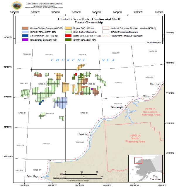 Figure 4: Map of the BOEMRE Chukchi Sea Outer Continental Shelf Planning Area. This map depicts current lease ownership in the Chukchi Sea by company. Shell leases are marked with the light green color. Map from BOEMRE. Figure 4: Map of the BOEMRE Chukchi Sea Outer Continental Shelf Planning Area. This map depicts current lease ownership in the Chukchi Sea by company. Shell leases are marked with the light green color. Map from BOEMRE.
|
Although Shell, ConocoPhillips, and Statoil all hold leases in the Chukchi Sea, Shell is the only company that has presented formal plans to BOEMRE to drill. The area where Shell has proposed to drill has an approximate water depth of 150 feet, expected drilling depth of approximately 7,000 to 10,000 feet, and an expected pressure of no more than 4,000 psi.28 This can be contrasted with the Macondo well, which had an approximate water depth of 5,000 feet, approximate drilling depth of 18,000 feet,29 and pressures of almost 12,000 psi.30
Shell received preliminary approval from MMS and the State of Alaska to drill up to three Chukchi Sea exploratory wells during the summer of 2010, which was confirmed upon judicial review by the 9th Circuit Court. However, a coalition of Alaska Native and environmental groups challenged the adequacy of the environmental review of Lease Sale 193, arguing violations under the National Environmental Policy Act, the Endangered Species Act, and the Administrative Procedures Act.viii On July 21, 2010, the Federal District Court for the District of Alaska found that BOEMRE had failed to comply with NEPA in certain circumstances. The court enjoined all activity under Lease Sale 193, and remanded to BOEMRE to address concerns with the environmental impact analysis.31 The issues to be addressed by remand included: a failure to analyze the environmental impact of natural gas development, a failure to determine whether missing information from the environmental impact statement was “relevant or essential,” and whether the costs of obtaining that information would be exorbitant or means for doing so unknown.32 On August 2, 2010, the court amended its ruling, clarifying that that scientific studies that had already been approved or were pending approval by BOEMRE for the summer of 2010 could proceed.33 This decision allowed Shell and Statoil to move forward with seismic tests in the Chukchi Sea during the remainder of 2010.34
Separate from the court activities, Secretary Salazar announced on May 27, 2010, that the Interior Department would postpone consideration of Shell’s proposal to drill exploratory wells in the Chukchi Sea during 2010. According to the Department of the Interior, the decision was based on the need for further information about spill risks and spill response capabilities in the Arctic.
Notes from this section
i Different parties define the “Arctic” in different ways. In this paper, the term “Arctic” will refer to the U.S. portion of the Arctic in the area north of the Arctic Circle. This definition of Arctic includes portions of the Chukchi Sea and [[Beaufort] Sea] within the U.S. exclusive economic zone, but does not include the Bering Sea.
ii In this paper, the “North Slope” will refer to the North Slope Borough (see map above).
iii The North Slope estimate was eventually revised to approximately 23 billion barrels. Research Council, Cumulative Environmental Effects of Oil and Gas Activities on Alaska's North Slope (Washington, D.C.: Academy Press, 2003), 12.
iv According to Shell, many of the wells had proven hydrocarbons, but were not produced because of low oil prices and a lack of volume available for shipping oil from the Arctic (the Trans-Alaska Pipeline was full at that time with Prudhoe Bay oil). Slaiby, letter to Commission Chairmen, November 5, 2010. Beaufort Sea Outer Continental Shelf Planning Area. This map depicts current lease ownership in the [[Beaufort] Sea] by company. Map from BOEMRE.
v On June 18, 2010, Secretary of the Interior Ken Salazar signed a Secretarial Order (No. 3302) to reorganize the Minerals Management Service (MMS) into to the Bureau of Ocean Energy Management, Regulation, and Enforcement (BOEMRE). This document will refer to MMS when discussing specific events that occurred or documents that were created before MMS was reorganized and renamed (to BOEMRE) in 2010.
vi All nine of the exploration wells that have already been drilled in the Beaufort in water deeper than 50 feet were drilled from floating vessels.
vii According to the EPA, “The Appeals Board is the final Agency decisionmaker on administrative appeals under all major environmental statutes that the Agency administers. It is an impartial body independent of all Agency components outside the immediate Office of the Administrator. The Board typically sits in panels of three judges and makes decisions by majority vote. Currently, nine experienced attorneys serve as counsel to the Board.”
viii Specifically, the Plaintiffs alleged that the Final Environmental Impact Statement: (1) did not adequately analyze and present the impacts of Lease Sale 193 on the environment and human communities; (2) failed to include essential missing information about the Chukchi Sea and the potential impacts of the lease sale, or explain why excluding this information is justified; (3) failed to adequately analyze the impact of the lease sale in the context of a warming climate; (4) understated the potential impacts of oil and gas development pursuant to the leases by analyzing a limited development scenario; (5) understated the risks of an oil spill; (6) failed to fully analyze the cumulative impacts to threatened eiders of the lease sale and other oil and gas development in threatened eiders’ Arctic habitat; and (7) provided a misleading analysis of the effects of seismic surveying. Village of Point Hope, et al v. Salazar, et al, 2010 WL 2943120 (D. Alaska July 21, 2010).
The Economics of Oil in Alaska
 Ice breaker. Credit:NOAA Ice breaker. Credit:NOAA
|
Oil is extremely important to the economy of Alaska. One model of the Alaskan economy calculated that about one-third of the jobs and personal income in 2005 depended on the petroleum industry.35 In fiscal year 2009, the state of Alaska collected $5.2 billion in revenues from the oil industry – this accounted for more than 88 percent of Alaska’s unrestricted general fund revenues.36 Oil production in Alaska (primarily from the onshore field at Prudhoe Bay) peaked in 1988 at slightly more than 2 million barrels per day.37 By 2009, it had fallen to approximately 645,000 barrels per day, a decline of more than two thirds.38 During this period of declining production, the potential economic losses to the state have been mitigated by higher oil prices, including record state revenues from oil and gas production in fiscal year 2008, and the need for workers to maintain aging equipment. However, the Energy Information Administration projects that Alaska’s production will continue to decline to 420,000 barrels per day by the end of this decade.39 Depending on oil prices, the economic reliance on oil production in Alaska could eventually become a liability for the state economy if production does continue to decrease.
In addition to causing direct fiscal problems, a significant decline in North Slope production could also threaten the viability of the [[Trans-Alaska Pipeline] System], which transports oil eight hundred miles from the reserves in Prudhoe Bay to the port of Valdez on Alaska's southern coast. The pipeline is the only means of delivery of North Slope oil for transport to markets. Challenges caused by lower oil volumes in the pipeline include lower pipeline temperatures, water separation and holdup, increased wax deposition, and ice formation. Alyeska Pipeline Service Company has stated that these problems could occur as early as 2013 (when they estimate that throughput may drop below 550,000 barrels per day and oil temperature in the pipeline will fall below 32ºF).40 Some operators estimate that by 2022, the flow could be down to 350,000 barrels a day, at which point “frost heaves could cause the underground portions of the pipeline to dangerously wrinkle and kink.”41
Offshore oil in the Arctic is seen by some as an important source for replacing the projected decrease in onshore production. In 2008, the U.S. Geological Survey estimated that approximately 84 percent of the undiscovered oil and gas in the Arctic is expected to occur in offshore areas.42 One scenario developed in a study by Northern Economics for Shell Exploration and Development in 2009 projected production from multiple Alaska offshore sites beginning in 2018, and eventually peaking at 1.8 million barrels of oil per day.43
If Arctic offshore production did significantly increase and new pipelines were built to connect the oil to the Trans-Alaskan Pipeline, the State of Alaska could expect to receive additional economic benefits in the forms of jobs and tax revenue.ix However, two points should be noted regarding this scenario. First, an assumption is made that capital investments will suffice to keep the 33-year-old [[Trans-Alaska Pipeline] System] maintained and safely operating over time. This strategy has been somewhat successful to date, with Alyeska Pipeline Service Company, acting on behalf of the pipeline’s owners, investing hundreds of millions of dollars over the last decade into various upgrades and improvements.44 However, issues surrounding the aging infrastructure include findings of major corrosion and an associated shut down in August 2006; an oil spill in May 2010 due to the failure of a relief valve control circuit; and a shut down due to an oil spill at a pump station in January 2011.45 Second, it should be noted that the State of Alaska does not reap as much oil and gas revenue from offshore federal leases as it does from onshore state lands under the current revenue system. The state does not receive any royalties, production tax, or property tax for activities on offshore federal leases beyond six miles from shore.46
Notes from this section
ix The same 2009 study by Northern Economics concluded: “OCS development could generate an annual average of 35,000 jobs over the next 50 years – a six percent increase compared to total statewide employment without OCS development.” Economics, Economic Analysis of Future Offshore Oil and Gas Development: Beaufort Sea, Chukchi Sea, North Aleutian Basin, ES-1.
Challenges of Oil Spill Response in the Arcticx
|
|
The Alaskan Arctic is characterized by extreme cold, varying forms and amounts of sea ice, seasonal darkness, high winds, extended periods of heavy fog, and week-long storms that approach hurricane (Hurricane) strength. The winter season generally lasts nine months – temperatures are usually below 0°F and can reach minus 58°F.47 In the North Slope, the sun does not rise above the horizon from mid-November to late January, creating a prolonged period of winter darkness.48 The Chukchi and [[Beaufort] Seas] are also covered by varying forms of ice for eight to nine months of the year. Early forming ice is weak and easily displaces to create pileups and ridges; by late winter, land-fast ice exists that is typically about 2 meters thick and often extends from the shoreline to a depth of about 15 meters.49 Offshore, there is a pack ice zone that moves with ocean circulations, consisting of first-year ice, multi-year ice floes, and ice islands. Sea ice begins to retreat northward around June, creating an open water season between (approximately) July and October that is conducive to oil and gas activities, including exploratory seismic work and drilling.50
The demanding physical conditions of the Arctic can both heighten the risk of an oil spill and limit the effectiveness of oil spill response operations.51 Due to the seasonality of these variables, a key factor affecting spill response would be the time of year that the spill occurred. The techniques available for oil spill response and their effectiveness are expected to be significantly different during summer or open water conditions, versus late fall through spring when ice and more extreme weather conditions exist. If an oil spill occurred late in the open water season or during the fall freeze-up, oil could become encapsulated within the ice for multiple months and would not likely be accessible for clean-up efforts until the spring.
BOEMRE has stated that the greatest needs for oil spill research and development include operational tools to detect and map oil in a variety of ice types, as well as effective response options for spilled oil in moving broken pack ice.52 Oil is difficult to locate if it moves under ice floes or becomes encapsulated into surrounding ice. Rather than relying on visual observation, responders to spills in icy conditions may have to rely on airborne remote sensing techniques and ground penetrating radar to detect oil, each of which have limiting factors.53 According to research conducted by SINTEF,xi aerial sensing has a high potential for detecting spills in very open drift ice, but a limited potential for spills in close pack ice.54 Ground penetrating radar units have been found to be capable of detecting thin oil layers beneath ice or snow,55 but their use could raise human safety concerns in real-world Arctic conditions because they are either used by personnel walking on the ice or are mounted on helicopters flying over the ice at a very low altitude.
Ice conditions can make mechanical containment and response efforts more difficult and dangerous. Sea ice can “reduce the effectiveness of containment booms by interfering with boom position, allowing oil to entrain or travel under the boom, or causing the boom to tear or separate.”56 High waves, strong winds, and currents will also decrease the effectiveness of booms to contain oil. In terms of recovery, mechanical recovery methods are generally developed for open water conditions: their effectiveness will depend greatly on the amount and type of ice on the water. Other potential containment and recovery challenges in ice conditions include: icing and freezing of equipment, clogging of equipment, limited access to oil, limited flow of oil to skimmers, separating oil from ice and water, forces in the ice field, and increased oil viscosity.57 On the positive side, ice could potentially trap large quantities of oil to allow for more efficient mechanical recovery of oil in certain pockets between larger ice floes.58 Based on research conducted by the State of Alaska and MMS in 2000, ice management strategies, like the use of ice breakers, would likely need to be employed to improve the effectiveness of mechanical containment and collection methods in Arctic ice conditions.59
Under optimal conditions, the response strategy with the best potential in the Arctic may be in situ burning, where the oil is burned off the surface of the water. Cold water temperatures and ice can enhance the effectiveness of in situ burning by limiting the spread of oil, herding the oil into thicker slicks, as well as slowing the weathering process.60 However, some Arctic conditions could also complicate in situ burning: certain ice conditions could reduce burn effectiveness or make it difficult to deploy fire boom; high winds and cold temperatures could make ignition difficult; and limited visibility due to winter darkness or fog could prevent burns from occurring or limit aerial operations.61
Laboratory and field experiments conducted by SINTEF and others have demonstrated that dispersants, which are chemicals applied to oil slicks to accelerate the dispersion of oil into the water column, have the potential to be effective in cold water and ice conditions.62 Similar to in situ burning, dispersant use is more effective before oil has a chance to emulsify and become weathered. As a result of expected slower weathering of spilled oil in the Arctic, there may be a longer initial window to effectively deploy dispersants. Application of dispersants is expected to be limited by both environmental conditions, including ice barriers limiting access to spilled oil, and harsh weather, which can limit aerial applications of dispersants.63 Additionally, energy may need to be put into the system in higher ice coverage areas in order for dispersants to be effective – SINTEF field experiments used boat thrusters to create enough energy for the dispersant to mix with spilled oil in high ice coverage areas.64 Regardless of their effectiveness, questions remain regarding the potential toxicity and impacts of dispersants on Arctic ecosystems.xii
There are also logistical issues related to oil spill response in the Arctic. The response to any spill in Arctic waters would be overseen by the Coast Guard under the requirements of the National Contingency Plan (Responding to oil spills in the U.S.). However, Coast Guard officials have noted over the past few years that they are ill-prepared to adequately respond.65 The Coast Guard lacks sufficient ice-class vehicles capable of responding to a spill under Arctic conditions: two of the three Coast Guard polar icebreakers are non-operational and have exceeded their service lives.66 Distance is another major hurdle, even in open water and good weather conditions. The nearest Coast Guard operations base to the Chukchi region is on Kodiak Island – approximately 1,000 miles from the offshore lease sites. The Coast Guard is currently completing a High Latitudes Study, with the goal of producing mission analyses related to: (1) polar ice breaking needs; (2) Coast Guard missions in the Arctic region; and (3) Coast Guard missions in the Antarctic region.67 These analyses are expected to refine future operational requirements and identify the mix of personnel resources and assets needed to carry out response efforts in the area.68 The study is being supplemented with information gained by the Coast Guard from establishing temporary, seasonal operating locations in the Arctic, and conducting periodic Arctic overflights.
The geographic isolation of the North Slope from the rest of Alaska also complicates Arctic oil spill response: the eight main North Slope communities are not connected to each other or the rest of the state by road, and the few major airstrips that could handle cargo aircraft in the area are not connected to highways or docks.69 The North Slope communities have limited infrastructure to support a potential influx of oil spill responders and equipment. Although the infrastructure at Prudhoe Bay could likely handle such an influx, it is not located within close proximity to many of the offshore areas where drilling is being proposed in the Chukchi Sea.
Notes from this section
x A detailed review of the challenges of oil spill response in the Arctic can be found in Oil Spill Commission Staff Working Paper No. 5.
xi SINTEF is a Norwegian research institute.
xii It should also be noted that there is no pre-approval for dispersant use in the U.S. Arctic Ocean, so the Alaska Regional Response Team would need to provide approval before the Federal On-Scene Coordinator could permit dispersant use in response to a spill. Research and Planning Group, Oil Spill Prevention and Response in the U.S. Arctic Ocean: Unexamined Risks, Unacceptable Consequences, 80.
Alaskan Native Subsistence Resource Issues in the Arctic
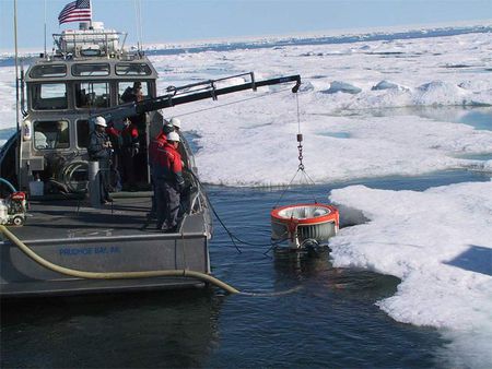 Disc-skimmer deployed in the Arctic. Credit: BOEMRE Disc-skimmer deployed in the Arctic. Credit: BOEMRE
|
Understanding the importance of Alaskan Native subsistence resource uses is vital to any discussion of offshore drilling in the Arctic. Inupiat Eskimos are the dominant population in Alaska’s Arctic region. They have survived in this isolated environment via subsistence hunting and fishing for thousands of years.70 Subsistence species include [whales], beluga whales, walruses, ice seals, bearded seals, arctic char, and caribou. However, the bowhead whale is of particular importance due to its size and food potential. Bowhead whales can reach 60 feet in length and weigh more than 120,000 pounds. The Bering–Chukchi–Beaufort stock of [whales] migrate into the Bering and [[Beaufort] seas] in late spring and early summer, spend the summer feeding primarily in the Canadian Beaufort, and then begin their westward migration back out of the Beaufort through the Alaskan Arctic in late August and early September.71 They are the most important subsistence animal for the coastal communities of northwest and northern Alaska.72 Although [whales] are not present in the Arctic year-round, whale hunting and the customs surrounding it are an important part of the cultural heritage of the Inupiat. According to the Mayor of the North Slope Borough:
“There are people here, [t]he Inupiat Eskimos have inhabited this land for thousands of years. Our health and our survival have always depended on what the land and sea give to us in the form of whales, caribou and other large coastal and marine mammals. . . In this respect, we do not differentiate ourselves . . . from the physical world that we live in. . . . [T]he fate of the ocean is our fate.”73
As a result of this direct connection to the ocean and its resources, BOEMRE has noted that many Inupiat are concerned about offshore “industrial activities that may directly or indirectly affect hunting success or the habitats of the species important to subsistence.”74 Much of this unease is related to seismic activities, but the threat of [[oil spill]s] is also a serious potential hazard. In case of a spill, whales may pass through the oil, exposing their bodies to harmful hydrocarbons. No research has studied the toxic effects of inhaled or ingested oil on [whales], but scientists believe the consequences would be similar to those for polar bears and seals, which are both seriously affected by oiling.75 Spills could also impact the food sources for the whales.
Arctic Ecological Resources
Arctic wildlife makes a substantial contribution to global biodiversity, with the region supporting globally significant populations of birds, mammals and fish.76 More than 100 phytoplankton species have been identified from the [[Beaufort] Sea]; a variety of zooplankton, jellyfish, kelp communities, and benthic invertebrates are also important components of Arctic marine ecosystems.77 In the Chukchi Sea, the melting and retreating ice edge during the spring leads to a highly productive and estuary-like nearshore corridor that serves as the base of the food chain for coastal and marine Arctic species. The Chukchi Sea's shallow and highly productive sea floor also allows benthic or bottom:dwelling prey, like crustaceans and mollusks, to flourish and create an important food source for wildlife specialized to feed at the ocean floor, such as walrus, seals, gray (Gray whale) whales, and deep-diving sea birds.78
The marine mammal fauna of the northern Bering, Chukchi, and Beaufort Seas are some of the most diverse in the world.79 Marine mammals found in this portion of the Arctic include four species of ice seals (bearded, ringed, spotted, and ribbon; bearded seals and [[ringed] seals] have recently been proposed for listing as threatened under the Endangered Species Act); multiple cetaceans, including bowhead (listed as endangered under the Endangered Species Act), beluga, gray (Gray whale), and killer whales, and harbor porpoise; walruses; and polar bears.80 The Chukchi Sea is “home to roughly half of America's polar bears, approximately 2,000 animals, or one-tenth of the world's population.”81 Humpback and fin whales (listed as endangered under the Endangered Species Act), and minke whales have been sighted recently in the Arctic as their range expands due to the effects of climate change; there have also been recent reports of narwhals.82 The distribution, movements, and life history events of many of these marine mammal species are closely linked with the presence or absence of sea ice.83 Seven marine mammal species “are present in the Arctic year-round and are often associated with the presence of sea ice: bowhead whale, beluga whale, narwhal, [[ringed] seal], [[bearded] seal], walrus, and polar bear.”84 Those species are also important top predators within Arctic marine ecosystems.
Bordered by the Beaufort and Chukchi seas, the North Slope of Alaska is very important to migratory birds. For many of these species, the concentration in the Arctic represents a substantial portion of their North American or world population.85 Shorebirds, seabirds and waterfowl concentrate in particular areas, such as the bays, lagoons, and river deltas lining the coast, where they can number into the tens of thousands. These areas are used by birds to rest, molt, and also acquire the necessary resources to successfully migrate. Inland tundra areas do not harbor such large aggregations but collectively may contain millions of nesting birds. Other birds, primarily waterfowl, sea ducks and seabirds, use the near and offshore areas for feeding and migration. The Chukchi Sea and areas to the south ([[Bering] Sea] and Bering Strait) support some of the largest colonies of marine birds in the northern hemisphere, with some colonies consisting of more than one million birds.86 Bird species in this area include two threatened (Spectacled and Steller’s Eider) and two candidate (Yellow-billed Loon, Kittlitz’s Murrelet) species on the Endangered Species list, as well as many other birds of conservation concern.87
Information regarding fish and fisheries (Fisheries and aquaculture in the Arctic) in the Beaufort and Chukchi Seas is much more limited than what exists for marine mammals and birds. Studies in the early 1990s reported 72 species of fish in the northeastern Chukchi Sea, and 62 species in the Alaskan Beaufort Sea.88 Marine fish species in the Beaufort Sea include: arctic char, rainbow smelt, arctic cod, saffron cod, sculpins, eelpouts, ciscoes, and whitefishes; in the Chukchi, the fish assemblage is similar, but also includes salmon and char.89 Snow crabs are also found in both seas.90 There are currently no commercial [[fisheries (Fisheries and aquaculture in the Arctic)] in the Arctic], except for small fisheries – mostly for salmon – that occur solely in state waters and are managed by the State of Alaska. As previously discussed, subsistence fishing is critical to local communities and occurs throughout the Arctic.91
In August 2009, the North Pacific Fishery Management Council took the proactive measure of completing a fishery management plan for the Arctic. This plan was conducted in recognition that the decrease of sea ice in the Arctic could eventually lead to commercial fishery interest in the area, as well as the fact that very little information exists that would be needed for commercial fishery management. The fishery management plan governs commercial fishing for all stocks of fish in the Arctic, including all finfish, shellfish, or other living marine resources (except Pacific salmon and Pacific halibut). The plan prohibits all commercial harvest of the previously listed fish species “until sufficient information is available to support sustainable management of a commercial fishery.”92
The unique and fragile ecosystems of the Arctic are under a great deal of pressure due to the impacts of climate change and associated decreases in sea ice. Scientists have determined that the Arctic is experiencing the impacts of a “prolonged and amplified warming trend, highlighted with many record-setting events,” in particular the dramatic losses of sea ice cover that define the marine region.93 Recent Arctic annual temperature increases are more than double those found at lower latitudes – the Arctic’s 2008 annual mean air temperature over land was the fourth warmest on record, continuing a long-term upward warming trend.94 The four smallest September ice extents have occurred in the past four years (the September 2010 sea ice extent was the third smallest in the past 30 years), and eight of the ten lowest summer ice minimums have occurred in the last decade.95 Presence of thicker multi-year sea ice has also decreased 35 percent in the last five years.96 These climatic changes are relevant to the discussion of oil and gas in the Arctic because the impacts of warmer temperatures and decreasing sea ice could weaken the natural ability of the Arctic ecosystems and/or individual species to recover from an oil spill.
Filling Scientific Data and Oil Spill Response Research Gaps in the Arctic
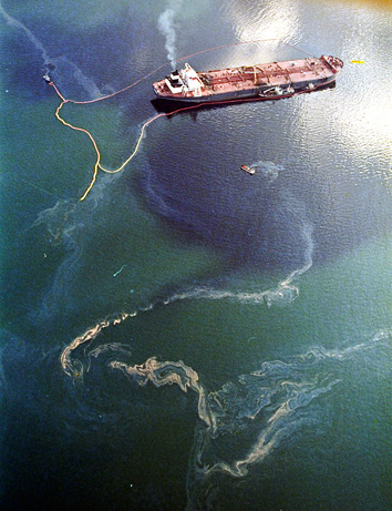 Until the BP oil spill of 2010 (see below), the most infamous U.S. oil spill was in 1989 off Prince William Sound on the Alaskan coast. The tanker Exxon Valdez ran aground against a reef and split open. Almost 11 of its 55 million gallons of oil escaped to open waters. Credit: NASA Until the BP oil spill of 2010 (see below), the most infamous U.S. oil spill was in 1989 off Prince William Sound on the Alaskan coast. The tanker Exxon Valdez ran aground against a reef and split open. Almost 11 of its 55 million gallons of oil escaped to open waters. Credit: NASA
|
As a result of the harsh weather and ice conditions in the Arctic, as well as the remoteness of the area, the Beaufort and Chukchi Seas have presented a serious challenge to researchers. Research in the Arctic tends to require high-priced assets (like ships, ice-breakers, and airplanes), is often limited to a short season due to ice or weather conditions, and can be very expensive to execute. Despite this, many useful scientific studies have or are being conducted in the Arctic by federal, state, and local government agencies, as well as native groups, universities, independent researchers, and the oil and gas industry. Traditional knowledge also plays an important role in understanding the Arctic and its resources.
A large portion of the studies under the BOEMRE Alaska Environmental Studies Program are conducted on a collaborative basis with federal, state, tribal, academic, private, and other partners. For example, BOEMRE has collaborated with NOAA (National Oceanic and Atmospheric Administration (NOAA), United States) to conduct surveys to understand seasonal marine mammal and fish distribution in certain areas of the Arctic. A partnership with the University of Alaska Coastal Marine Institute (CMI) was created in 1993 through a cooperative agreement between the University of Alaska and MMS Alaska Region. Research under the agreement focuses on coastal topics associated with the development of natural gas, oil and minerals in Alaska’s OCS. According to BOEMRE, matching research funds have come from more than “50 different organizations and [have] leveraged over $15 million of MMS funds into $30 million worth of relevant marine-based research.”97 The BOEMRE Alaska Environmental Studies Program also conducts cooperative research with universities through Cooperative Ecosystem Studies Units. The Northwest Alaska Cooperative Ecosystem Studies Unit is hosted by the University of Alaska, with the University of New Hampshire and the Alaska SeaLife Center serving as partners.98
The oil and gas industry is also conducting research in the Arctic in support of potential exploration and development of offshore oil and gas resources. Following the 2005 lease sale in the [[Beaufort] Sea], Shell restarted its Arctic science program. Research topics include ice, oceanography, meteorology, marine mammals, sediment chemistry, benthic organisms, onshore hydrology, cultural resources, and marine ecosystem-based studies.99 In 2008, a multidisciplinary program to develop baseline science was also established jointly between Shell, ConocoPhilips, and Statoil in the areas of their Chukchi Sea lease sites. Intensive sampling throughout a 30 by 30 nautical mile grid is collecting a variety of data (fish, birds, marine mammals, plankton, benthic invertebrates, physical and chemical oceanography, etc) that are focused on better understanding ecosystem processes; seasonal and interannual variability; and the relationship to sea ice dynamics.100
Although the insights derived from these diverse studies and traditional knowledge have made contributions to our current understanding of the Arctic, additional research in other geographic and topical areas is needed. This is particularly important as oil and gas development and other anthropogenic activities increase (such as commercial fishing, shipping, tourism, and Navy activities). Broad baseline data across the Arctic are critical to understand the potential ecological sensitivities of areas that may be leased for oil and gas activities, especially with respect to the potential impacts to individual species and the larger ecosystem once those activities begin. In addition, significant research is needed related to oil spill response in Arctic conditions. BOEMRE has recognized this need in its FY11 Annual Studies Plan for Alaska:
“In consideration of these recent events and dynamic circumstances, our studies planning process faces administrative and budgetary challenges for which we are adjusting our research priorities. Our FY11 priorities now include: updates and improvements in our oil spill risk analysis models; lab research on biological effects of oil/gas and dispersants in cold water; planned workshops to document Gulf spill“lessons learned” for spill planning and response in arctic waters, as well as multilateral preparation for damage assessment fieldwork protocols; improved baseline for monitoring shorezone habitat and bioremediation (Bioremediation); and efforts to enhance oil spill detection technologies and “nowcast” oceanographic instrumentation. Additional efforts to update and improve data collection for catastrophic event analysis in the arctic will undoubtedly follow in FY12.” 101
Other federal efforts underway related to the Arctic resources include preparation of an Arctic Management Plan and a science gaps analysis. In July 2010, President Obama signed Executive Order 13547, adopting the Final Recommendations of the Interagency Ocean Policy Task Force as the National Policy for the Stewardship of the Oceans, Our Coasts and the Great Lakes.102 This Policy established a National Ocean Council and nine Priority Objectives for implementation, including a priority objective for Changing Conditions in the Arctic. The Policy requires the National Ocean Council to develop National Strategic Action Plans for all of the priority objectives. In preparing its plan for the Arctic, the National Ocean Council is instructed to work with all stakeholders, including indigenous communities, to develop a proactive and science-based plan to manage and encourage use, while protecting the fragile Arctic environment.103
Separately, the Department of the Interior has directed an evaluation of existing Arctic science information, which is being led by the U.S. Geological Survey and is expected to be completed in spring 2011. This report will synthesize what is known about the Beaufort and Chukchi Seas. According to the Department of the Interior, “the report will examine the effects of exploration activities on marine mammals; determine what research is needed for an effective and reliable oil spill response in ice-covered regions; evaluate what is known about the cumulative effects of energy extraction on ecosystems and other resources of interest; and review how future changes in climate conditions may either mitigate or compound the impacts from Arctic energy development.”104
A number of high profile and high priority data gaps for the Arctic are discussed below. This is in no way meant to be an exhaustive list of topics or data gaps (for example, it does not cover birds or oceanographic data), but it does provide a sense of the types of studies that are needed to provide a broader understanding of the Arctic. Without this broad understanding, it is difficult to put the more detailed and site-specific environmental studies being conducted by the industry at lease sites into context. Implementing these studies would help managers better understand the potential scope and severity of anthropogenic impacts to key components of the entire Arctic ecosystem. They will also be important in the case of an oil spill, because the scientific data is needed to inform the Natural Resource Damage Assessment (Natural Resource Damage Assessment: evolution, current practice, and preliminary findings related to the Deepwater Horizon oil spill) process.xiii
Notes from this section
xiii The Oil Pollution Act of 1990 requires that a Natural Resource Damage Assessment (Natural Resource Damage Assessment: evolution, current practice, and preliminary findings related to the Deepwater Horizon oil spill) (NRDA) be conducted after a release of oil into the environment. The goal of the process is to compensate the public for damages to natural resources, as well as adverse impacts on the public use and enjoyment of those resources. Trustees carry out this assessment through three steps: (1) identification of an adverse impacts on natural resources and/or human use of the resources; (2) quantification of the impacts; and (3) implementation of publicly-vetted compensatory restoration. A spill in the Alaskan Arctic would pose multiple challenges for the logistics of the NRDA process. The remoteness of the region would significantly impede the collection of time-sensitive data because scientists would not be able to quickly reach the affected site due to the lack of roads and weather-dependent air transportation. Additionally, the prolonged periods of darkness and storms would make meaningful data collection extremely difficult. The NRDA would also have to address damages to the human use of resources, such as the bowhead whale population and other marine mammals used for subsistence by the native communities along the Chukchi and Beaufort Sea coastlines.
Marine Mammals Data Gaps
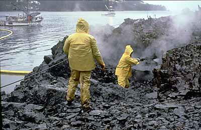 Workers using high-pressure, hot-water washing to clean an oiled shoreline in Prince William Sound. Credit: Incident News Workers using high-pressure, hot-water washing to clean an oiled shoreline in Prince William Sound. Credit: Incident News
|
The BOEMRE Alaska Environmental Studies Program has funded a significant amount of marine mammal research, mostly focused on a few marine mammal species that are both listed under the Endangered Species Act and that are important for the Alaska Native subsistence harvest. Four major multi-year studies of [whales] and cetaceans in the Arctic are currently being conducted under an interagency agreement between BOEMRE and NOAA (National Oceanic and Atmospheric Administration (NOAA), United States):
- The Bowhead Whale Aerial Survey Project (BWASP) has been conducting surveys of [whales] during their fall migration through the western [[Beaufort] Sea] since 1979 in order to characterize the general fall migration pattern. These surveys are conducted between Barrow, AK and the Canadian border and occur from late August to mid-October.
- The Chukchi Offshore Monitoring in Drilling Area (COMIDA) study seeks to increase scientific knowledge about broad patterns of seasonal distribution and abundance of cetaceans. COMIDA surveys are conducted in BOEMRE’s Chukchi Sea Planning Area in the northeastern section of the Chukchi Sea from mid-June to late October.
- The Bowhead Whale Feeding Ecology Study (BOWFEST) is a multiyear study that started in 2007. It focuses on late summer oceanography and prey densities relative to bowhead whale distribution in offshore waters within 100 miles north and east of Point Barrow, Alaska.105
- The Chukchi Sea Acoustics, Oceanography and Zooplankton (CHAOZ) study employs a multidisciplinary approach to combine information on cetacean distribution with oceanography to provide an integrated look at how changing regional and local conditions are affecting cetaceans.106
Despite these studies, basic stock assessments and baseline data on Arctic marine mammal abundance, trends in abundance, stock structure, and distribution are inadequate. NOAA (National Oceanic and Atmospheric Administration (NOAA), United States) does not have funding for regular Arctic marine mammal stock assessments. As a result, reliable abundance estimates are not available for most Arctic marine mammal species, and trends in abundance are unknown for nearly all species.107 To establish current baselines for assessment purposes and to allow for Natural Resource Damage Assessment (Natural Resource Damage Assessment: evolution, current practice, and preliminary findings related to the Deepwater Horizon oil spill) in case of an oil spill, the following areas of Arctic marine mammal research should be considered a high priority:
- Improvements in techniques to assess the abundance, stock structure, and trends in abundance of Arctic marine mammals.
- Local, regional, and seasonal distributions of Arctic marine mammals.
- Understanding and predicting how climate change will impact marine mammals.
- Acoustics research, focused on impacts of anthropogenic sound on marine mammals, how marine mammals use sound, and how sound can be used to assess marine mammal populations.
- General health and effects of contaminant loads and disease on marine mammals.
Marine Fisheries and Habitat Data Gaps
Because of the lack of commercial fishing and the difficult research conditions, NOAA (National Oceanic and Atmospheric Administration (NOAA), United States) has not conducted regular marine fish stock assessments in the Arctic. The BOEMRE Alaska Environmental Studies Program has also not placed a strong emphasis on marine fisheries. As a result, only a handful of major marine fish surveys have ever been conducted in the Arctic:
- In 1959 and 1976, two dedicated marine fish and invertebrate surveys using bottom trawls and other gears were conducted in the southeastern Chukchi Sea.
- In 1976 and 1977, the [[Beaufort] Sea] and a small portion of the northeastern Chukchi Sea were sampled opportunistically with a bottom trawl during a marine mammal survey.
- In 1990 and 1991, a multidisciplinary study of the northeastern Chukchi Sea was conducted by the University of Alaska Fairbanks, including a comprehensive bottom trawl survey.
- Joint Russian-American surveys have occurred several times since 2004.
- In 2008, with support from BOEMRE, the NOAA Alaska Fisheries Science Center conducted a detailed survey of the western part of the [[Beaufort] Sea] using bottom trawls, hydroacoustics, and other gears.108
BOEMRE has stated that the fisheries data that exist in the Arctic focus “mostly on adult fish in the nearshore environment during the open-water season,” and “tend to address general distribution and abundance – very limited information regarding discrete populations, migration, offshore occurrence, and life history” are available at this time.109 Because of the difficulty in conducting fisheries surveys in ice conditions, data regarding marine fish during pack ice and fast ice conditions are also extremely rare. Many of the Arctic research needs that were identified by the National Research Council in 1993 appear to still be applicable in 2010, including trophic ecology, life history (migration patterns, growth rates, feeding habits, and reproduction), and offshore distribution.110 In addition, the following research would be important to understand the recovery rates of sensitive benthic habitats, determine the specific location and productivity of fish habitats, and understand the impacts of climate change – all of which are relevant to understanding and measuring the impacts of oil and gas activities in the Arctic and providing baseline data for Natural Resource Damage Assessment (Natural Resource Damage Assessment: evolution, current practice, and preliminary findings related to the Deepwater Horizon oil spill) in case of a spill:
- Forecasting distribution and abundance of managed species based on decreasing sea ice levels.
- Assessing whether spatial shifts are creating new biological communities, thus altering food webs and migrations.
- Characterizing habitat utilization and productivity for living marine resources.
- Assessing sensitivity, impact, and recovery of disturbed benthic habitats.
- Developing seafloor maps for Arctic waters.
- Understanding the current subsistence use of marine fish.
- Understanding the reliance of Arctic marine mammals on marine fish species, so that potential conflicts with new commercial fisheries can be highlighted and mitigated early in the planning process.
Oil Spill Response Research Gaps
The Oil Pollution Act of 1990 established the Interagency Coordinating Committee on Oil Pollution Research.xiv The purpose of the committee is to: “(1) prepare a comprehensive, coordinated federal oil pollution research and development plan; and (2) to promote cooperation with industry, universities, research institutions, state governments, and other nations through information sharing, coordinated planning, and joint funding of projects.”111 The work of the committee includes Arctic components, but is more broadly focused to cover all areas of oil pollution research. In its December 2009 Biennial Report to Congress, the committee recognized the complex issues associated with oil spill response in the Arctic, and noted a commitment to continue “to coordinate and remain cognizant of cold-water response research and development studies.”112
As part of this group, MMS/BOEMRE has operated an Oil Spill Response Research Program that includes an Arctic component. Between 1997 and 2008, MMS conducted 31 research projects that were “directly related to improving equipment and processes for the prompt identification and removal of oil from harsh Arctic environments.”113 Many of these projects were conducted with partners from state and federal government agencies, academia, private industry, and other countries.
A large amount of BOEMRE funded oil spill response research is conducted at Ohmsett – The National Oil Spill Response Research & Renewable Energy Test Facility. This New Jersey facility is managed by BOEMRE and contains one of the largest outdoor saltwater tanks in North America: it measures 667 feet long by 65 feet wide, and holds 2.6 million gallons of water.114 The tank is designed to test oil spill response techniques and full-scale response equipment with oil under controlled environmental conditions. It is able to simulate both cold water and broken ice conditions. Both Ohmsett and the Oil Spill Response and Research Programs receive funding appropriated under the Oil Spill Liability Trust Fund.xv
Important research has also been conducted by the industry in partnership with various governments and research institutions. SINTEF undertook significant Arctic oil spill research through the three-year Joint Industry Program on oil spill contingency for Arctic and ice-covered waters, which was established in 2006 and ended in 2009. The program completed multiple research projects specific to oil spill response in cold water and ice conditions, including: fate and behavior of spilled oil; in situ burning; mechanical recovery; remote sensing; and oil distribution and bioavailability. As part of the program, laboratory and medium-scale experiments were taken one step further and tested in ice conditions in the Barents Sea during two large-scale field experiments that focused on [[mechanical recovery] methods], in situ burning, and [[dispersant] application]. According to SINTEF, “a significant data set has been collected that will aid in understanding more about oil in ice, including such issues as:oil weathering; the window of opportunity for various oil spill countermeasures; the interaction between ice and water; the bio availability of released oil in ice; and information on oil-ice drift.”115
As the potential for oil and gas activity increases in the Arctic, it is critical for the U.S. to develop better science and protocols related to oil spill response in the unique weather, water, and ice conditions of the Arctic. Despite all of the research that has already been conducted, there are still many significant data gaps related tooil spill response in Arctic conditions. According to the U.S. Arctic Research Commission, “the promise of a rigorous and coordinated national research program on oil spills, made in the Oil Pollution Act of 1990, after the Exxon Valdez disaster, has fallen short.”116 Despite advances in field research made by SINTEF and its partners, Arctic oil spill response technologies remain “largely untested and unproven in the harsh real-world conditions” that exist in the Arctic.117 In addition to the need for a higher level of consistent, long-term funding for Arctic oil spill response research, there are a number of areas that would benefit from additional research, particularly field testing in harsh Arctic conditions:
- Detecting oil trapped under ice.
- Removing or cleaning oil spilled under ice.
- The operability of oil spill response equipment in Arctic conditions.
- The effectiveness of dispersants, in situ burning, and herding agents in Arctic conditions.
- The environmental impacts of using dispersants, in situ burning, and herding agents in Arctic conditions.
- Oil spill trajectories in the Arctic.
- The economic, environmental, and societal impacts oil spills may have on Alaskan communities. This would encompass incorporating the knowledge of Arctic communities into preparedness, response, assessment, and restoration activities to address the human dimensions of spills.
Notes from this section
xiv Members of the Committee include: Department of Commerce (NOAA, and National Institute of Standards and Technology); Department of Energy; Department of the Interior (BOEMRE and U.S. Fish and Wildlife Service); Department of Transportation (Maritime Administration, and Pipeline and Hazardous Materials Safety Administration); Department of Defense (U.S. Army Corps of Engineers, and U.S. Navy); Environmental Protection Agency; National Aeronautics and Space Administration; Department of Homeland Security (U.S. Coast Guard, Federal Emergency Management Agency, and U.S. Fire Administration).
xv The Oil Spill Liability Trust Fund receives funds from a $0.08 tax on each barrel of oil produced or imported into or out of the United States. U.S.C. § 4611. Note: In October 2008, Congress raised the tax per barrel from $0.05 to $0.08 until January 1, 2017, and to $0.09 from January 1, 2017 to December 31, 2017.
Summary and Findings
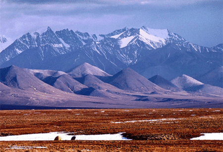 Mountains of the Arctic National Wildlife Refuge. Credit: FWS Mountains of the Arctic National Wildlife Refuge. Credit: FWS
|
The topic of offshore oil and gas development in the Arctic is controversial and tends to elicit strong responses. Research by the Commission staff has revealed a broad range of views related to Arctic oil and gas. The issues explored include potential environmental impacts; economic benefits and economic beneficiaries of activities; potential impacts on Alaskan Native subsistence harvest; effectiveness of oil spill response methods in the unique weather and ice conditions of the Arctic; and industry’s ability to respond to an oil spill in the Arctic. Commission staff has found that there are many areas related to oil and gas development in the Arctic that warrant targeted research and strengthening of infrastructure on an expedited time frame. Some of these activities could be conducted concurrently with exploratory drilling by current lease holders, while others are urgent enough to require at least partial solutions before further drilling occurs. The following findings should be taken into consideration by the Department of the Interior as the Department considers whether oil and gas development in the Arctic should be allowed to move forward, and at what pace:
1. The Arctic is home to a number of unique, diverse, and fragile ecosystems that are under stress from the impacts of climate change. There are currently large gaps in the ecological information available in the Arctic Ocean, including the Beaufort and Chukchi Seas. Although some research has been completed for a handful of species during certain times of the year, a better understanding of more components of the marine ecosystem throughout the entire year is needed. Without these data, it will be extremely difficult to predict and monitor the impacts of offshore oil and gas activities, or conduct damage assessments in the event of an oil spill.
2. The Inupiat Eskimos of Alaska’s remote arctic and subarctic communities rely heavily on subsistence resources of the marine environment, particularly [whales]. Whale hunting and the customs surrounding it are also an important part of the cultural heritage of the Inupiat. Oil and gas development has the potential to directly or indirectly affect hunting success or the habitats of species important to subsistence, which in-turn would have a negative impact on native communities. However, offshore oil and gas development could also provide some level of increased economic opportunity to the communities.
3. There is currently a large gap in knowledge related to oil spill response in the Arctic. Arctic conditions can be very dangerous to humans, and include extremely cold air and water temperatures, strong winds, multiple forms of ice, and fog. As a result, successful oil spill response methods from the Gulf of Mexico cannot simply be transferred to the Arctic and expected to work in exactly the same way. Although industry, government, and research institutions have partnered to conduct important research on this topic, much more information is needed related to the effectiveness and safety of Arctic oil spill response methods.
4. There could be a large difference in the effectiveness of Arctic oil spill preparedness, response, and containment efforts related to exploratory drilling versus year-round oil and gas production. Exploratory drilling would likely be confined to a relatively short time period during open water conditions, which should facilitate oil spill response and containment operations. As a result, a different scale or type of information and response capabilities are needed for the two activities. There are outstanding questions regarding what both government and industry need to demonstrate in terms of information and capabilities in advance of each type of activity. An evaluation of these outstanding requirements is important to providing regulatory transparency and certainty to the industry.
5. There is a large deficiency in federal capabilities related to oversight of oil spill response in the Arctic. The response to any spill in Arctic waters would be managed by the Coast Guard under the requirements of the National Contingency Plan (Responding to oil spills in the U.S.). The distance from the nearest Coast Guard base to the Arctic is a major hurdle, even in open water and good weather conditions. Additionally, two of the three Coast Guard polar icebreakers are non-operational and have exceeded their service lives. Even though industry is required to be capable of carrying out oil spill response, the Coast Guard may not be able to provide required oil spill oversight, or search and rescue support. The Coast Guard is currently carrying out a High Latitudes Mission Analysis to understand its needs for future operations, personnel, and assets in the Arctic.
6. The Arctic is shared by multiple countries, many of which are considering or conducting oil and gas exploration and development. The extreme weather conditions and infrastructure difficulties are not unique to the U.S. portion of the Arctic – they exist throughout the entire region. The damages caused by an oil spill in one part of the Arctic may not be limited to the waters of the country where it occurred. As a result, international cooperation and standards for Arctic oil and gas activities are very important. The Arctic Council has begun work in this direction, updating its voluntary Arctic Offshore Oil and Gas Operation Guidelines in 2009. The International Standards Organization is also in the process of developing international standards for Arctic offshore structures that would apply to the activities of petroleum and natural gas industries in Arctic and cold regions. These guidelines are expected to specify requirements and provide recommendations and guidance for the design, construction, transportation, installation, and removal of offshore structures in the Arctic.
7. Oil from the Arctic OCS can serve as a source to replace declining production on land in Alaska. Although the level of economic stimulus provided by the activities can be debated, it is expected to have an economic benefit for the State of Alaska. If production is transported via the Trans-Alaska Pipeline (after being transported from the production site to the pipeline), it could help deal with the range of problems related to decreasing flow in the pipeline. Additional oil from the Alaska OCS will also provide energy, economic, and national security benefits to the United States. The federal government would obtain substantial revenues from any further lease sales and from royalties on any future production. Offshore Arctic oil could also help to reduce U.S. imports of oil and the country’s negative balance of trade in energy.
End Notes
1 "Purchase of Alaska,” Library of Congress; “Alaska Purchase,” Britannica Concise Encyclopedia.
2 “Modern Alaska: Oil Discovery and Development in Alaska,” Alaska Humanities Forum.
3 Ibid.
4 Ibid.
5 “History of Northern Alaska Petroleum Development,” American Petroleum Institute, March 10, 2009.
6 “Modern Alaska: Oil Discovery and Development in Alaska,” Alaska Humanities Forum.
7 Charles Thomas, Walter North, Tom Doughty, and David Hite, Alaska North Slope Oil and Gas: A Promising Future or an Area in Decline? (April 8, 2009), 2-26.
8 Bureau of Ocean Energy Management, “Lease Sales,” January 3, 2011.
9 J.D. Hall, “Oooguruk Project Offshore Alaska,” Offshore, August 1, 2008; BP, BP in Alaska (2004), 34, 38.
10 [Slaiby, letter to Commission Chairmen, November 5, 2010.]
11 “Beaufort Sea,” ExxonMobil; BP, BP in Alaska, 34.
12 BP, BP in Alaska, 34.
13 Ibid, 38.
14 “Liberty Project, Alaska, USA,” Offshore Technology.
15 Ibid.
16 Jim Efstathiou Jr., “BP’s Liberty Oil Well in Alaska to Face New Safety Rules,” Bloomberg, June 24, 2010.
17 Patty Epler, “BP Slows Down Plans for Liberty Oil Field,” Alaska Dispatch, July 6, 2010.
18 Yereth Rosen, “BP suspends construction work on Alaska Liberty rig,” Reuters, November 30, 2010; Samantha Zee, “BP Suspends Construction of Liberty Rig in Alaska,” Bloomberg Businessweek, November 30, 2010.
19 “Oooguruk, USA,” Offshore Technology.
20 Shell Offshore Inc, Sivulliq Location N: Camden Bay Exploration Plan, Beaufort Sea OCS Region, Alaska: Executive Summary, (October 2010), 1; Susan Childs, letter to Jeff Walker, October 5, 2010.
21 Alan Bailey, “Going for the Beaufort; Shell applies for Sivulliq well in ’11,” Petroleum News, October 10, 2010.
22 Alan Bailey, “Shell to eliminate mud discharge in Beaufort,” Petroleum News, December 19, 2010.
23 Press Release, Department of the Interior, Salazar Announces Revised OCS Leasing Program, December 1, 2010.
24 Alan Baily, “New Shell Hurdle: Environmental Appeals Board returns air quality permits to EPA for rework,” Petroleum News, January 9, 2011.
25 [Slaiby, letter to Commission Chairmen, November 5, 2010.]
26 Bureau of Ocean Energy Management, “Lease Sales,” January 3, 2011.
27 Minerals Management Service, Alaska OCS Region, “Summary of Company Bids,” February 7, 2008.
28 [Slaiby, letter to Commission Chairmen, November 5, 2010.]
29 “Offshore Field Development Projects – Macondo,” Subsea IQ.
30 BP, Deepwater Horizon Accident Investigation Report (September 8, 2010), 22.
31 [Village of Point Hope, et al v. Salazar, et al, 2010 WL 2943120 (D. Alaska July 21, 2010).]
32 [Village of Point Hope, et al v. Salazar, et al, 2010 WL 2943120 (D. Alaska July 21, 2010).]
33 Native Village of Point Hope, et al v. Salazar, et al, 2010 WL 3025163 (D. Alaska August 2, 2010).
34 Yereth Rosen, “Shell, Statoil get OK to do Chukchi Oil Surveys,” Reuters, August 6, 2010.
35 Scott Goldsmith, “The Importance of Petroleum to the Alaska Economy: A Gedanken Experiment” (paper, Annual Meeting of the North American Regional Science Association, San Francisco, CA, November, 2009), 20.
36 Resource Development Council, “Alaska’s Oil and Gas Industry."
37 Energy Information Administration, “Annual Alaska Field Production of Crude Oil,” July 29, 2010.
38 Ibid.
39 Energy Information Administration, Annual Energy Outlook 2011, Table A14.
50 Greg Jones, letter to Commission Chairmen, November 1, 2010.
51 Kim Murphy, “The flow has slowed through the trans-Alaska oil pipeline,” Los Angeles Times, August 10, 2010.
42 U.S. Geological Survey, Circum-Arctic Resource Appraisal: Estimates of Undiscovered Oil and Gas North of the Arctic Circle (2008).
43 Northern Economics, Economic Analysis of Future Offshore Oil and Gas Development: Beaufort Sea, Chukchi Sea, North Aleutian Basin (March 2009), ES-7.
44 Rose Ragsdale, “Big Risk, Bigger Rewards: Life expectancy climbs as pipeline ages,” Petroleum News, February 15, 2010.
45 Associated Press, “North Slope Shutdown to Cut U.S. Oil Output,” Los Angeles Times, August 7, 2006; Tim Bradner, “5,000 barrels spilled at Alyeska pump station,” Alaska Journal of Commerce, June 4, 2010; Mary Milliken and Bill Rigby, “Alaska Pipeline Shut Down After Leak Discovered,” Reuters, January 9, 2010.
46 Interview with government official, November 7, 2010.
47 National Research Council, Cumulative Environmental Effects of Oil and Gas Activities on Alaska's North Slope (Washington, D.C.: National Academy Press, 2003), 2, 24.
48 Ibid, 2.
49 Ibid, 27.
50 Ibid.
51 Written testimony of Dennis Kelso, Ocean Conservancy, Hearing before the National Commission, submitted September 22, 2010, 2.
52 BOEMRE, “Technology Assessment and Research Project Categories – Arctic Oil Spill Response Research,” December 1, 2010; MAR, Inc. et al., Empirical Weathering Properties of Oil in Ice and Snow Project Number 1435-01-04-RP-34501 Final Report U.S. Department of the Interior Minerals Management Service Alaska Outer Continental Shelf Region (October 2008).
53 U.S. Department of the Interior, Minerals Management Service, Arctic Oil Spill Response Research and Development Program: A Decade of Achievement (2009).
54 SINTEF, Joint industry program on oil spill contingency for Arctic and ice-covered waters – Summary Report (April 10, 2010), 30.
55 SINTEF, Joint industry program on oil spill contingency for Arctic and ice-covered waters – Summary Report , 30.
56 Written testimony of Dennis Kelso, 4.
57 SINTEF, Joint industry program on oil spill contingency for Arctic and ice-covered waters – Summary Report, 9.
58 Ibid.
59 National Research Council, Cumulative Environmental Effects of Oil and Gas Activities on Alaska's North Slope, 218.
60 SINTEF, Joint industry program on oil spill contingency for Arctic and ice-covered waters – Summary Report , 17.
61 Nuka Research and Planning Group, LLC (commissioned by the Pew Environment Group), Oil Spill Prevention and Response in the U.S. Arctic Ocean: Unexamined Risks, Unacceptable Consequences (November 2010), 65-66.
62 SINTEF, Joint industry program on oil spill contingency for Arctic and ice-covered waters – Summary Report , 21.
63 Nuka Research and Planning Group, Oil Spill Prevention and Response in the U.S. Arctic Ocean: Unexamined Risks, Unacceptable Consequences, 80-81.
64 SINTEF, Joint industry program on oil spill contingency for Arctic and ice-covered waters – Summary Report, 21-23.
65 Captain J.J. Fisher, “Policy & Cooperation in the Arctic” (presentation, Capitol Hill Ocean Week, June 10, 2010); Captain J.J. Fisher “Oil Spill Response in the U.S. Arctic: A U.S. Coast Guard Perspective” (presentation, Environmental Law Institute, March 11, 2010).
66 Ronald O’Rourke, Coast Guard Polar Icebreaker Modernization: Background, Issues, and Options for Congress (Congressional Research Service, July 2, 2010), 1.
67 U.S. Government Accountability Office, Coast Guard Efforts to Identify Arctic Requirements are Ongoing, but More Communication about Agency Planning Efforts Would be Beneficial (September 2010), 24.
68 Testimony of Captain Caplis, U.S. Coast Guard, Hearing before the National Commission, September 27, 2010, 349.
69 Written testimony of Dennis Kelso, 8.
70 National Research Council, Cumulative Environmental Effects of Oil and Gas Activities on Alaska's North Slope, 19, 135.
71 R. Schick and D. Urban, “Spatial components of bowhead whale distribution in the Alaskan Beaufort Sea,” Can. J. Fish. Aquat. Sci. 57: 2193–2200, 2000.
72 Lori Quakenbush, “Bowhead Whale,” Alaska Department of Fish & Game, September 22, 2010.
73 Testimony of Mayor Edward Itta, North Slope Borough, Hearing before the National Commission, September 27, 2010, 351.
74 BOEMRE, Alaska OCS Region, Alaska Annual Studies Plan – Final FY 2011 (October 2010), 5.
75 National Research Council, Cumulative Environmental Effects of Oil and Gas Activities on Alaska's North Slope, 101.
76 Michael Gill, Arctic Report Card 2010: Biology (NOAA, October 15, 2010), 65.
77 National Research Council, Cumulative Environmental Effects of Oil and Gas Activities on Alaska's North Slope, 4.
78 Audubon Alaska, “Chukchi Sea.”
79 National Research Council, Environmental Information for Outer Continental Shelf Oil and Gas Decisions in Alaska (Washington, D.C.: National Academy Press, 1994), 88.
80 Interview with government official, November 2, 2010.
81 Audubon Alaska, “Chukchi Sea.”
82 Interview with government official, November 2, 2010.
83 National Research Council, Environmental Information for Outer Continental Shelf Oil and Gas Decisions in Alaska, 88.
84 M. Simpkins, Arctic Report Card 2010: Marine Mammals (NOAA, October 19, 2010), 68.
85 National Research Council, Environmental Information for Outer Continental Shelf Oil and Gas Decisions in Alaska, 97.
86 Ibid, 98.
87 M. A. Smith, Arctic Marine Synthesis: Atlas of the Chukchi and Beaufort Seas (Anchorage: Audubon Alaska and Oceana, 2010).
88 National Research Council, Environmental Information for Outer Continental Shelf Oil and Gas Decisions in Alaska, 106.
89 Ibid, 107-8.
90 North Pacific Fishery Management Council, Fishery Management Plan for Fish Resources of the Arctic Management Area (August 2009), 13.
91 Shawn Booth, Dirk Zeller, and Daniel Pauly, Baseline Study of Marine Fisheries Catches from Arctic Alaska: 1950-2006 (November 2008).
92 North Pacific Fishery Management Council, Fishery Management Plan for Fish Resources of the Arctic Management Area (August 2009), ES-1.
93 J. Richter-Menge and J.E. Overland, eds., Arctic Report Card 2010 (NOAA, October 2010), 6.
94 NOAA, Arctic Vision and Strategy (April 2010), 1; J. Overland, M. Wang, and J. Walsh, Arctic Report Card 2010: Atmosphere (NOAA, October 14, 2010), 8-9.
95 J. Richter-Menge and J.E. Overland, eds., Arctic Report Card 2010, 7.
96 NOAA, Arctic Vision and Strategy, 1.
97 BOEMRE, Alaska OCS Region, Alaska Annual Studies Plan – Final FY 2011, 4.
98 Ibid, 4-5.
99 Shell, Science of the U.S. Arctic Outer Continental Shelf, vol. 1 (November 2010), 25.
100 Shell, Science of the U.S. Arctic Outer Continental Shelf, vol. 1 (November 2010), 26.
101 BOEMRE, Alaska OCS Region, Alaska Annual Studies Plan – Final FY 2011, x.
102 “The Interagency Ocean Policy Task Force,” Council on Environmental Quality.
103 White House Council on Environmental Quality, Final Recommendations of the Interagency Ocean Policy Task Force (July 19, 2010), 39.
104 Press Release, Department of the Interior, Secretary Salazar Unveils Arctic Studies Initiative that will Inform Oil and Gas Decisions for Beaufort and Chukchi Seas, April 13, 2010.
105 “NOAA National Marine Mammal Lab: Cetacean Assessment & Ecology Program: Bowhead Whale Aerial Surveys: Preliminary Data,” Alaska Fisheries Science Center.
106 Interview with government official, January 3, 2011.
107 M. Simpkins, Arctic Report Card 2010: Marine Mammals, 68.
108 North Pacific Fishery Management Council, Fishery Management Plan for Fish Resources of the Arctic Management Area, 9.
109 Office of Leasing and Environment, Alaska OCS Region, MMS 2010-022 Environmental Assessment: Beaufort Sea Planning Area, Shell Exploration & Production: Ancillary Activities, Marine Surveys (July 2010), 17.
110 National Research Council, Environmental Information for Outer Continental Shelf Oil and Gas Decisions in Alaska, 107-9.
111 Interagency Coordinating Committee on Oil Pollution Research, Biennial Report for Fiscal Years 2008 and 2009 (December 2009), 4.
112 Interagency Coordinating Committee on Oil Pollution Research, Biennial Report for Fiscal Years 2008 and 2009 (December 2009), 10.
113 U.S. Department of the Interior, Minerals Managament Service, Arctic Oil Spill Response Research and Development Program: A Decade of Achievement, 2.
114 “Ohmsett.”
115 SINTEF, Joint industry program on oil spill contingency for Arctic and ice-covered waters – Summary Report, 23.
116 U.S. Arctic Research Commission, White Paper: U.S. Arctic Commission Recommends Steps to Expand U.S. Funding for Arctic/Subarctic Oil Spill Research (May 26, 2010), 1.
117 Written testimony of Dennis Kelso, 4.