Outer Continental Shelf
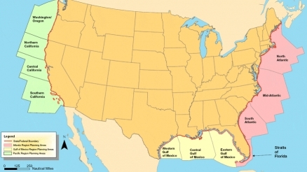
The U.S. Outer Continental Shelf consists of the submerged lands, subsoil, and seabed in a specified zone up to 200 nautical miles or more offshore from U.S. coasts.
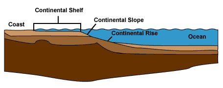
The continental shelf (Physiography of the ocean basins) is the gently sloping undersea plain between a continent and the deep ocean. The continental shelf (Physiography of the ocean basins) is an extension of the continent's landmass under the ocean. The waters of the Continental Shelf are relatively shallow (rarely more than 150 to 200 meters deep) compared to the open ocean (thousands of meters deep). The continental shelf extends outward to the continental slope where the deep ocean truly begins. The figure above is a schematic diagram of the continental shelf. The width of the continental shelf around the U.S. varies from approximately 20 to 400 km. The continental shelf regions are important economically, primarily because their waters are the source of much seafood, and because of the energy these regions provide, both in the form of fossil fuels, such as oil and gas, and renewable energyresources.
 Continental shelf. Credit: Office of Naval Research Continental shelf. Credit: Office of Naval Research
|
The U.S. Outer Continental Shelf (OCS) as defined by the Federal government consists of the submerged lands, subsoil, and seabed, lying between the seaward extent of the States' jurisdiction and the seaward extent of Federal jurisdiction. State jurisdiction is defined as follows:
- Texas and the Gulf coast of Florida are extended 3 marine leagues (9 nautical miles) seaward from the baseline from which the breadth of the territorial sea is measured.
- Louisiana is extended 3 imperial nautical miles (imperial nautical mile = 6080.2 feet) seaward of the baseline from which the breadth of the territorial sea is measured.
- All other States' seaward limits are extended 3 nautical miles (approximately 3.3 statute miles) seaward of the baseline from which the breadth of the territorial sea is measured.
Federal jurisdiction is defined under accepted principles of international law. The seaward limit is defined as the farthest of 200 nautical miles seaward of the baseline from which the breadth of the territorial sea is measured or, if the continental shelf can be shown to exceed 200 nautical miles, a distance not greater than a line 100 nautical miles from the 2,500-meter isobath or a line 350 nautical miles from the baseline.
Outer Continental Shelf limits greater than 200 nautical miles but less than either the 2,500 meter isobath plus 100 nautical miles or 350 nautical miles are defined by a line 60 nautical miles seaward of the foot of the continental slope or by a line seaward of the foot of the continental slope connecting points where the sediment thickness divided by the distance to the foot of the slope equals 0.01, whichever is farthest.
For legislation concerning the OCS, the United States Senate Committee on Commerce, Science & Transportation has jurisdiction within the United States Senate.
Within the United States government, the The Bureau of Ocean Energy Management, Regulation and Enforcement (BOEMRE), also known as the Bureau of Ocean Energy (BOE), and formerly known as the Minerals Management Service (MMS), is the agency charged to provide regulatory oversight of deepwater oil drilling and offshore wind energy (Energy return on investment (EROI) for wind energy) sources in U.S. Federal waters that extend beyond State jurisdiction.[4]
Sources
Outer Continental Shelf (OCS), Department of the Interior, Bureau of Ocean Energy Management, Regulation and Enforcement, Accessed 26 November 2010.
