Mt. St Helena Flows and Valleys
Contents
Mt. St. Helena Flows and Valleys
| Topics: |
Geology (main)
|
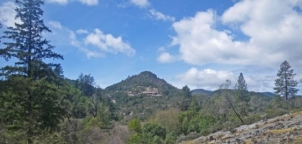
St. Helena Palisades, Mayacamas Range, Napa County. @ C.Michael Hogan
The Mt.St.Helena Flows and Valleys subsection is on the northwest trending Sonoma, Mayacamas, and Howell Ranges that are dominated by the Sonoma volcanics, and the valleys of the Napa River and Sonoma Creek between these mountain ranges. This section encompasses MLRAs 14d and 15d.
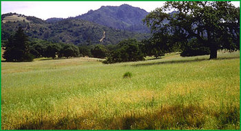 Subsection 263Am, near Kenwood (Charles B. Goudey)
 Lithology and Stratigraphy
This subsection contains predominantly Sonoma volcanics, which are Pliocene basalt to rhyolite flows and pyroclastic rocks. There are moderately large areas of Franciscan rocks of the Central Belt and other Cretaceous sedimentary rocks, presumably of the Great Valley sequence, with considerable ultramafic rock associated with them. Plio-Pleistocene sediments, Quaternary terraces, and recent alluvium are extensive in and around the valleys of the Napa River and Sonoma Creek.
Geomorphology
This subsection contains three parallel mountain ranges and large stream valleys between these ranges. The mountains are steep, with moderately steep hills around their margins. The stream valleys have extensive floodplains and undissected to dissected terraces. The elevation range is from near sea-level in the lower part of the Napa River up to about 4343 feet on Mount Saint Helena, but most of the area is below 3000 feet. Mass wasting and fluvial erosion are the main geomorphic processes.
Soils
The soils are mostly Lithic Xerochrepts, Lithic Haploxerolls, Vitrandepts, and Ultic Haploxeralfs. On Cretaceous rocks, the main soils are Lithic Xerochrepts, Haploxeralf, and Argixerolls. On Pleistocene sediments the are Typic Haploxerults and Chromic Pelloxererts. On Quaternary terraces they are Haploxeralfs and Durixeralfs. And on late Quaternary or recent alluvium they are Haploxerolls, Argixerolls, and Haploxeralfs. The soil temperature regimes are mesic and thermic. Soil moisture regimes are mostly xeric, with some udic.
Vegetation
The natural plant communities are mainly Coast Live Oak series, and, to lesser extent, Oregon white oak series, at lower elevations and on south-facing slopes at higher elevations; Douglas-fir series in moist canyons and on north-facing slopes; and Chamise series on shallow soils. There are small areas of Redwood series. Valley oak series and Needlegrass grasslands prevail in the valleys and on terraces.
Characteristic series by lifeform include:
- Grasslands: California annual grassland series, Introduced perennial grassland series, Purple needlegrass series.
- Forests and woodlands: Black oak series, Coast live oak series, Douglas-fir series, Knobcone pine series, Mixed oak series, Oregon white oak series, Redwood series and Valley oak series.
Climate
The mean annual precipitation is approximately 20 to 60 inches. Mean annual temperature is about 45° to 58°F. The mean freeze-free period is about 200 to 275 days.
Surface Water
Water runs off to streams and alluvial plains moderately rapidly and all but the larger streams are dry by the end of the summer. There are no natural lakes, but several reservoirs and many artificial ponds.
See Also
Return to Northern California Coast