Mount Emei and Leshan Giant Buddha, China
Contents
- 1 Introduction
- 2 Geographical Location
- 3 Date and History of Establishment
- 4 Area
- 5 Land Tenure
- 6 Altitude
- 7 Physical Features
- 8 Climate
- 9 Vegetation
- 10 Fauna
- 11 Cultural Heritage
- 12 Local Human Population
- 13 Visitors and Visitor Facilities
- 14 Scientific Research and Facilities
- 15 Conservation Value
- 16 Conservation Management
- 17 IUCN Management Category
- 18 Further Reading
Introduction
Mount Emei and Leshan Giant Buddha (29°16'N-9°43'N, 103°10'E-103°37'E) is a World Heritage Site located in China.
Geographical Location
Located in the center of the Sichuan Province, the nominated area includes Mount Emei Scenic and Historical Area, west of Emeishan City, and the Leshan Giant Buddha Scenic Area, located to the south-east of Leshan City at the confluence of three rivers: Minjiang, Dadu and Qinqyi.
Both Scenic Areas, separated by about 40 kilometers (km), are linked by road and are approximately 140 km south-west of Chengdu, the provincial capital with access by highway. 29°16'N-9°43'N, 103°10'E-103°37'E
Date and History of Establishment

Mount Emei has been protected since the middle of the 10th century, when an agency was set up at the Baishui Temple (currently Wannian Temple) for the management and conservation of the area.
An area of 11,500 hectares (ha) was approved as a Scenic Area under the provisions of Approval Document No. Chuanfufa (1982) No.1 of the Sichuan Provincial People's Government. In 1982 Mount Emei Scenic Area was approved as a place of Scenic and Historical Interest by the State Council of the People's Republic of China. In 1988 the State Council appointed Emeishan City as the responsible government authority for protection and administration of Mount Emei Scenic Area. The Mount Emei Administration was duly established and has assumed governmental duties for the preservation and management of the area. A general plan for the site, with regulations, was drafted by provincial government (Proposal for Approval of the General Plan of the Mount Emei Scenic Area (Chuanfufa (1994) No.91) and approved by the State Council in 1995.
Inscribed as a mixed natural/cultural World Heritage property in 1996.
Area
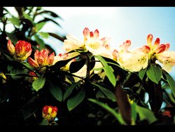
15,400 ha (Mount Emei Scenic Area). Five zones ("nature reserves"), have been established within the area, four for the conservation of threatened plants and one for landscape protection. These comprise a protected zone for Rhododendron (70h a), a protected zone for Davidia involucrata, Tetracentron sinense and Cerdifiphyllum japonicum (30ha), a protected zone for Abies sp., Kingdonia uniflora and Trillium tschonoskii (400 ha), a protected zone for Phoebe zhennan (20 ha), and a protected zone for natural landscapes (85 ha).
Land Tenure
State.
Altitude
Ranges from the 500 meters (m) at the plains to 3,099 m at the highest peak of Mt. Emei, the Wanfoding Summit.
Physical Features
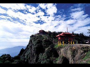
Mount Emei emerges from the western margin of the Chengdu Plain, with a relative height difference of 2,600 m. Its most varied topography includes a range of landscapes of undulating hills, valleys, deep gullies and high peaks. Three summits of Mount Emei stand in parallel, forming a characteristic landscape when viewed from a distance.
The majority of the late Precambrian sedimentary strata are well developed and easily identified. These sediments contain a large number of fossils and are an important source of geological information. Of particular stratigraphic significance are the "Maidiping" section of Late Precambrian-Cambrian, the "Longmendong" Triassic section and the Mount Emei basalt. A wide range of soils is found, the best represented are yellow earth, mountain yellow earth, yellow brown earth, mountain dark brown earth and subalpine podzolic soil.
The principal rivers are the Black, Emei, and White, and other significant hydrological features included brooks, rivulets, pools, springs and waterfalls. Longmendong and Yixiantian gorges are direct result of water erosion. The abundant rainfall on carbonate rocks has developed a number karstic features, including the Shisungou karst forest, Jiulaodong karst cavern and Jiaopenba underground river.
Climate
The climate varies significantly with altitude from an annual mean of 3°C in the cold-alpine zone to 17.2°C in the subtropical zone. The site is frequently covered in dense clouds, with associated high humidity (85%) and rainfall (mean annual precipitation is 1,992 millimeters (mm)).
Vegetation

Mount Emei contains both Sino-Japanese and Sino-Himalayan flora with a total vegetation coverage of 87%.
Five vegetation belts are defined according to vertical zonation. In ascending height order they are: subtropical evergreen broad-leaved forest (below 1,500 m), evergreen and deciduous broad-leaved mixed forest, coniferous and broad-leaved mixed forest, subalpine coniferous forest and subalpine shrubs above 2,800 m.
Some 3,200 plant species in 242 families have been recorded, of which 31 are under national protection, representing approximately one third of the total number of plants in the Sichuan province and one tenth of those found in China. There are some 1,600 species of medicinal plants, and 600 species of commercial interest. More than one hundred species are endemic, including Parakmeria omeiensis, Sibbaldia omeiensis, Piper omeiensis, Betula trichogemma, Salix omeiensis, Pericamphylus omeiensis, Itea omeiensis, Puerartia edulis, Dryopteris omeiensis, Ctenitis pseudorhodolepis and Acrophorus omeiensis. A total number of 29 species of Rhododendron sp. has been recorded, some being endemic. A list of protected species and a list of endemic plants is given in MoC (1995).
Fauna
Some 2,300 animal species have been recorded of which 29 are under national protection, 157 species being threatened]or endemic animals to China. A number of type specimens have been taken from Mount Emei. The fauna comprises 51 mammals, 256 birds, 34 reptiles, 33 amphibians, 60 fish, 42 oligochaetes and over 1,000 insect species.
A number of internationally threatened species are found including lesser (red) panda Ailurus fulgens (V), Asiatic black bear Selenarctos thibetanus (V), mainland serow Capricornis sumatrensis (I), Asiatic golden cat Felis temmincki (I), Tibetan macaque Macaca thibetana (K), Chinese giant salamander Andrias davidianus (I) and Grey-hooded parrotbill Paradoxornis zappeyi (R). A list of notable animals is given in MoC (1995).
Cultural Heritage

Archaeological evidence indicates that the area was inhabited as long as 10,000 year ago. Both Mount Emei and the Leshan Giant Buddha are places of historical importance, being one of the four holy lands of Chinese Buddhism. Mount Emei's history has been documented and recorded for over 2,000 years during which time a rich Buddhist cultural heritage has accumulated, including cultural relics, architectural heritage (including 30 temples), collected calligraphy, paintings, tablet inscriptions and earthenware. There is a list of the relics and monuments in MoC (1995).
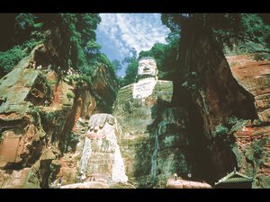
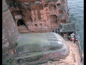
Leshan Giant Buddha, which covers 2,500 ha, includes a number of significant cultural artifacts. These include the sitting Giant Buddha Statue, carved on the Xiluo Peak of Mount Lingyun in the early 8th century and standing 71 m high, with its back against Mount Jiuding and facing the confluence of Minjiang, Dadu and Qinqyi rivers. In addition there are more than 90 stone carvings Buddhist shrines made during the Tang Dynasty; the Lidui (a large rock cut in the center of the river for irrigation purposes); tombs, Buddha statues, pagodas, temples and city walls.
Local Human Population
Some 2,000 people live inside the Scenic Area, including a number of monks and nuns living in the temples and monasteries. Small scale farming is conducted along the edges of the site.
Visitors and Visitor Facilities

Mount Emei is a place of pilgrimage, and is also visited by artists, writers, scientists and tourists. The major tourist services are provided in Emeishan City. Some 300,000 visitors visit the summit yearly, with 100,000 using the traditional trail route, the remainder arriving by cable car. A visitor center is located at the base of the Mount. Entrance fee is approximately US$4.
Scientific Research and Facilities
There are 15 specialized institutions such as the Forests and Seeds Centre, the Biotic Resource Experimental Station, and the Emeishan Museum. International scientific research has been carried out on geology, geomorphology, biological resources, architecture, religious culture, history and art. This has provided the scientific basis for the protection, management and development of the Scenic Area. Numerous botanical studies have been undertaken in the Mount Emei area resulting in many samples being added to collections world wide.
Conservation Value
The site represents a well preserved landscape that contains a diverse natural environment and a rich cultural heritage. Biologically, the area supports a high diversity of plant and animal species including a number of endemic and globally threatened species. Historically it has been a site of great relevance for Chinese Buddhism. Mount Emei is known for being of great aesthetic value, being referred as the "Buddhist Paradise"and "Celestial World on Earth".
Conservation Management
At present the conservation and administration of Mount Emei is subject to the provisions of government regulations and laws, such as the Forest Law, the Law of Environmental Protection, the Law for Protection of Cultural Relics, the Provisional Regulations concerning the Places of Scenic and Historic Interest promulgated by the State Council in 1985. In addition there are a number of local legal instruments in force. These include the Provisional Regulations for Administration of Scenic Places in Sichuan promulgated by Sichuan Provincial People's Congress in 1994, and other local regulations and government decrees. The governments of Sichuan, Leshan and Emeishan exercise joint management. Sichuan Provincial Construction Commission is the responsible government organ for conservation, construction, management, planning and implementation. The responsible administrative organ is the Mount Emei Administration, under the leadership of the Emeishan People's Government, with four branch administrative offices at Baoguo Temple, Jiulaodong, Wannian Temple and Golden Summit. These are responsible for management and implementation of the conservation plans.
The area has a General Plan, approved by the State Council. This includes specialised plans such as the Plan for Conservation and Management of Mount Emei Wild Animals and Plants, the Plan for Conservation and Management of Mount Emei Cultural Relics and Ancient Buildings, and the Plan for Mount Emei Fire Prevention. The General Plan establishes three management zones, comprising the scenic area, a buffer zone from 2 km to 7 km in width and a third zone covering an unknown size.
Four protected management zones have been established, for rare and endangered (IUCN Red List Criteria for Endangered) plants and one for natural landscape. There are 31 plant species and 29 animal species receiving protection at a state level.
Management Constraints
Pressure from tourism is evident at the Golden Summit. Waste is an attendant problem as is the proliferation of drinks stands and souvenirs stalls which detract from the natural atmosphere of the mountain. Already many of the trails are overcrowded and developments are proceeding around the margins of the site. Construction of a small scale railway from the Golden Summit to connect it with Wanfoding Summit (3 km) was halted after about 1 km of work was begun. The damage caused will be subject to restoration efforts.
Staff
Comprises 158 professionals and personnel, 40 of them being scientists.
Budget
No information.
IUCN Management Category
- V (Protected Landscape)
- Natural World Heritage Criterion (iv)
Further Reading
An extensive bibliography is provided in MoC (1995) including scientific, history and arts publications.
- MoC (1995). World Heritage Convention, Natural/Cultural Heritage: China, Mount Emei and Leshan Giant Buddha. Proposal for World Heritage Nomination. Ministry of Construction. 150 pp.
| Disclaimer: This article is taken wholly from, or contains information that was originally published by, the United Nations Environment Programme-World Conservation Monitoring Centre (UNEP-WCMC). Topic editors and authors for the Encyclopedia of Earth may have edited its content or added new information. The use of information from the United Nations Environment Programme-World Conservation Monitoring Centre (UNEP-WCMC) should not be construed as support for or endorsement by that organization for any new information added by EoE personnel, or for any editing of the original content. |