Montserrat
| Topics: |
This content is not assigned to a topic
|
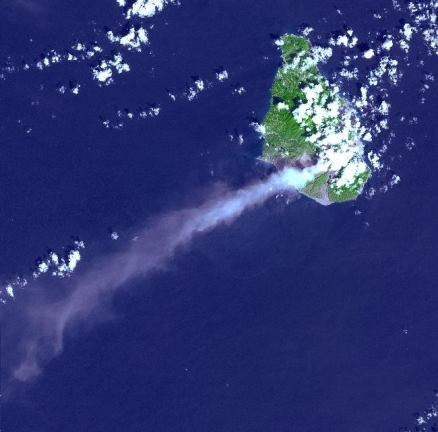
Image taken 29 October 2002. Source: NASA
Countries and Regions of the World Collection  Montserrat is British overseas territory with just over 5,000 people located in the Leeward Islands, part of the chain of islands called the Lesser Antilles in the Caribbean Sea, southeast of Puerto Rico.
It measures approximately 16km (10 miles) long and 11km (7 miles) wide, giving 40kilometres (25mi) of coastline.
The island is entirely volcanic in origin and comprised of three major volcanic centers of differing ages Much of this island was devastated and two-thirds of the population fled abroad because of the eruption of the Soufriere Hills Volcano that began on 18 July 1995. A massive eruption in 1997 destroyed most of the capital, Plymouth, and resulted in approximately half of the island becoming uninhabitable. Montserrat has endured volcanic activity since, with the last eruption occurring in July 2003. Eruptive activity of the Soufriere Hills Volcano on Montserrat is evidenced in the image above by an extensive smoke and ash plume streaming towards the west-southwest.

English and Irish colonists from St. Kitts first settled on Montserrat in 1632; the first African slaves arrived three decades later.
The British and French fought for possession of the island for most of the 18th century, but it finally was confirmed as a British possession in 1783.
The island's sugar plantation economy was converted to small farm landholdings in the mid 19th century.
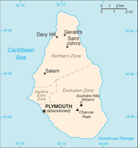 Map of Montserrat (Source: CIA, The World Factbook)
 Its major environmental issues include land erosion which occurs on slopes that have been cleared for cultivation.
Geography
Location: Caribbean, island in the Caribbean Sea, southeast of Puerto Rico
Geographic Coordinates:16 45 N, 62 12 W
Area: 102 sq km
arable land: 20%
permanent crops: 0%
other: 80% (2005)
Land Boundaries: 0 km
Coastline:40 km
Maritime Claims: Territorial sea to 3 nautical miles; exclusive fishing zone to 200 nautical miles
Natural Hazards: Severe hurricanes (June to November); volcanic eruptions (Soufriere Hills volcano has erupted continuously since 1995)
Terrain: Volcanic island, mostly mountainous, with small coastal lowland. The highest point is lava dome in English's Crater (in the Soufriere Hills volcanic complex) estimated at over 930 m (2006).
Climate: tropical; little daily or seasonal temperature variation.
Capital: Plymouth
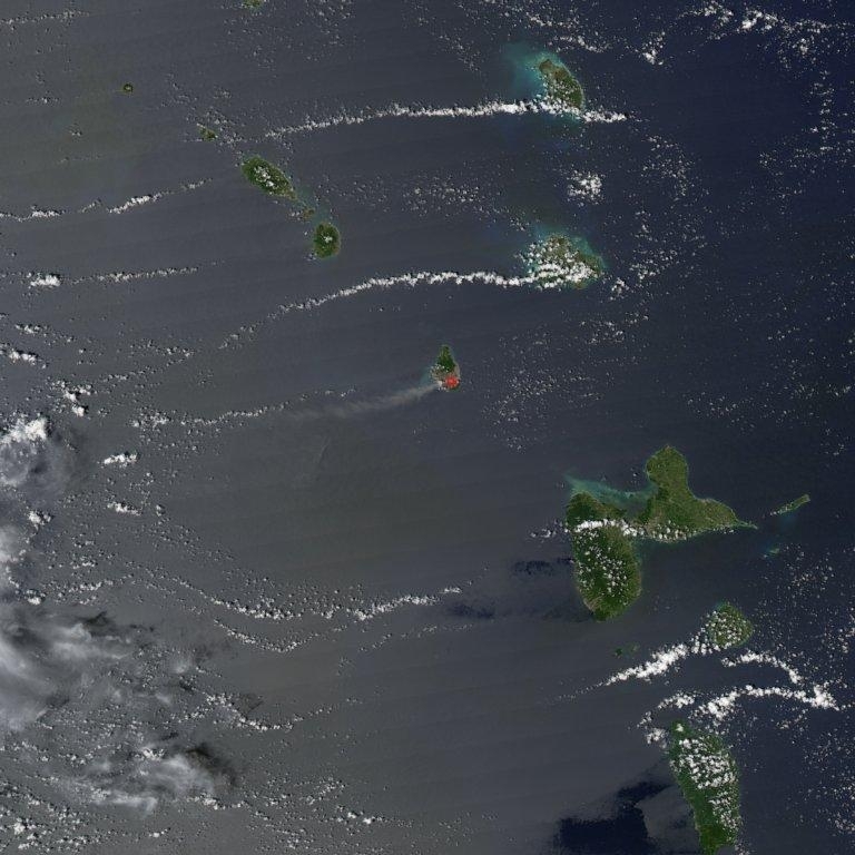
The Soufriere Hills Volcano on the island of Montserrat produced a plume of volcanic ash and/or steam on 1 October 2006, part of a continuing pattern of intermittent eruptions. In this image, the island of Montserrat shows an area outlined in red - the thermal hotspot. The plume of volcanic ash blows westward over the Caribbean Sea, gradually dissipating as it moves away. No recorded eruptions of the volcano occurred before 1995, but since then, volcanic ash emissions have posed recurring health hazards for Montserrat's residents. Photo courtesy of NASA.
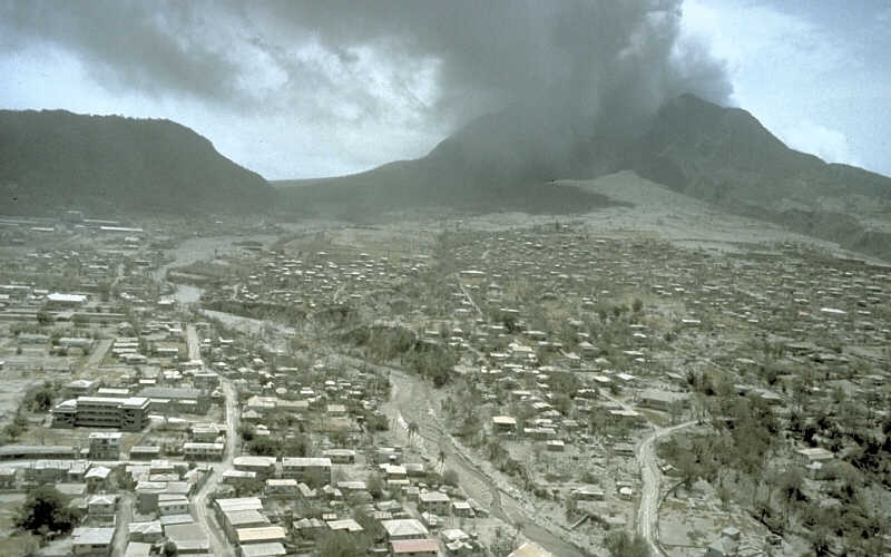
View E across ash-covered Plymouth, the former capital city and major port of Montserrat, toward Soufriere Hills volcano. Before the volcano became active in July 1995, about 5,000 people lived in Plymouth, located 4 km west of English's Crater. During the first two years of the eruption, ash and noxious gas from explosions and pyroclastic flows frequently settled on Plymouth. On August 3, about 3 weeks after this image was taken, the first significant pyroclastic flow swept through the evacuated town. The flow triggered many fires and caused extensive damage to buildings and community facilities by direct impact and burial.12 July 1997. Source: R.P. Hoblitt/U.S. Geological Survey
Ecology and Biodiversity
Ecologically, Montserrat is part of the Leeward Islands moist forests ecoregion and with the Caribbean Islands biodiversity hotspot.
The Caribbean Islands hotspot consists mainly of three large groups of islands between North and South America: the Bahamas, the Lesser Antilles, and the Greater Antilles (Puerto Rico, Jamaica, Cuba, and Hispaniola, which includes the Dominican Republic and Haiti). Politically, the Caribbean (sometimes called the West Indies) comprises 12 independent nations and several French, British, U.S. and Dutch jurisdictions.
The Caribbean is an important biological region due to its rich vegetation and the large number of endemic plants. Plant diversity and endemism are very high in the Caribbean Islands, with an estimated 13,000 species, including more than 6,500 single-island endemics. Endemism at higher levels is also exceptional, with 205 plant genera and one plant family, the Goetziaceae, found nowhere else on Earth.
The Caribbean is also rich in fauna. The Islands have nearly 90 mammal species, of which more than 40 are endemic. There are more than 600 bird species in the Caribbean Islands, of which roughly 160 are endemic. The Caribbean Islands are particularly rich in reptiles, with over 500 reptile species, almost 470 of which (94 percent) are endemic. The Caribbean is also a center of amphibian endemism, with all of the roughly 170 native species of amphibians from four {C}families of frogs (the Bufonidae, Dendrobatidae, Hylidae, and Leptodactylidae) endemic to the hotspot. All but a few species are endemic to single islands. The Caribbean Islands have more than 160 species of freshwater fish, about 65 of which are endemic to one or a few islands, and many of these to just a single lake or springhead.
The British Virgin Islands are part of the Leeward Islands of the Caribbean. The western part of the British Virgin Islands contain a small portion of the Leeward Islands moist forests, an important ecoregion.
The Leeward Islands are similar to other Caribbean islands in having a relatively high degree of island-endemism. The amount of diversity and number of island endemics in the Lesser Antilles is related to island size, diversity of habitat, and distance from the mainland or another island.
See:
People and Society
Population: 5,164 (July 2012 est.)
Age Structure:
0-14 years: 26.9% (male 717/female 665)
15-64 years: 66.6% (male 1,648/female 1,777)
65 years and over: 6.5% (male 208/female 125) (2011 est.)
Population Growth Rate: 0.484% (2012 est.)
Birthrate: 11.62 births/1,000 population (2012 est.)
Death Rate: 6.78 deaths/1,000 population (July 2012 est.)
Net Migration Rate: 0 migrant(s)/1,000 population (2012 est.)
Life Expectancy at Birth: 73.41 years
male: 75.15 years
female: 71.58 years (2012 est.)
Total Fertility Rate: 1.27 children born/woman (2012 est.)
Languages:English
Literacy: (age 15 and over has ever attended school) 97% (1970 est.)
Urbanization: 14% of total population (2010) growing at an annual rate of change of 2.4% (2010-15 est.)
Economy
Severe volcanic activity, which began in July 1995, has put a damper on this small, open economy. A catastrophic eruption in June 1997 closed the airports and seaports, causing further economic and social dislocation. Two-thirds of the 12,000 inhabitants fled the island. Some began to return in 1998, but lack of housing limited the number. The agriculture sector continued to be affected by the lack of suitable land for farming and the destruction of crops. Prospects for the economy depend largely on developments in relation to the volcanic activity and on public sector construction activity. The UK has launched a three-year $122.8 million aid program to help reconstruct the economy. Half of the island is expected to remain uninhabitable for another decade.
GDP: (Purchasing Power Parity): $43.78 million (2008 est.)
GDP- per capita (PPP): $8,500 (2006 est.)
GDP- composition by sector:
agriculture: 1.6%
industry: 23%
services: 75.3% (2011 est.)
Industries: tourism, rum, textiles, electronic appliances
Natural Resources:NEGL
Currency: East Caribbean dollars (XCD)