Mid-ocean ridges (About the EoE)
Contents
Mid-ocean ridges
| Topics: |
Geology (main)
|
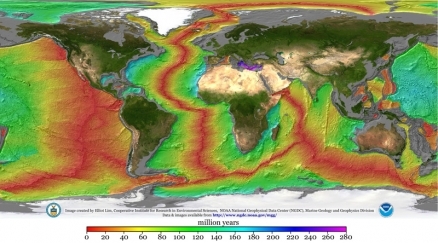
The following image shows the age of the oceanic crust found beneath the oceans. On this image, the mid-ocean ridges become apparent because they represent crust of recent origin. (Image Source: Elliot Lim, CIRES & NOAA/NGDC)
Mid-ocean ridges are a series of largely underwater mountain ranges that are present beneath many seas of the world. Mid-ocean ridges are topographic features found where divergent tectonic plate processes are moving two pieces of oceanic crust away from each other.
At the mid-ocean ridges, newocean floor is continuously being created from rising magma originating from the Earth's mantle. The creation of the new oceanic crust pushes older crust away from the ridge in a conveyor belt fashion. Thisprocess is known as sea-floor spreading.The fracture can be seen beneath the ocean as a line of ridges that form as molten rock reaches the ocean bottom and solidifies. A narrow depressed area running along the center of the ridges, called a rift, is the region where volcanic activity is adding magma to the two diverging pieces of oceanic crust.
The mid-ocean ridges themselves are broken by offsets know as transform faults, breaks in the Earth's crust which run perpendicular to the ridge. Transform faults are formed by the pressure of the magma which forces the crust upward and breaks it into a string of tilted blocks.
Plate Tectonics
The theory of plate tectonics tells us that the Earth's rigid outer shell (lithosphere) is broken into a mosaic of oceanic and continental plates that can slide over the plastic aesthenosphere (uppermost layer of the mantle). The plates are in constant motion. There are seven major crustal plates, subdivided into a number of smaller plates (Figure 1.) They are about 80 kilometers thick, moving relative to one another at rates varying from 1 to 13 centimeters per year. Their pattern is neither symmetrical nor simple. Several different landform features found on our planet - mountains, rift valleys, volcanoes, earthquakes, faulting (Fault) - are the result of geologic processes that occur where plates interact.
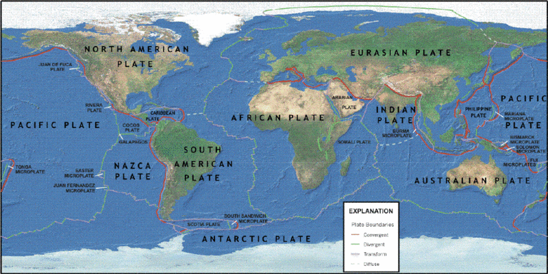 Figure 1. Main tectonic plates of the Earth. (Image Source: USGS).
There are four types of plate boundaries:
- Divergent boundaries -- where new crust is generated as the plates pull away from each other (green lines in Figure 1).
- Convergent boundaries -- where crust is destroyed as one plate dives under another (red lines in Figure 1).
- Transform boundaries -- where crust is neither produced nor destroyed as the plates slide horizontally past each other (grey continuous lines in Figure 1).
- Plate boundary zones -- broad belts in which boundaries are not well defined and the effects of plate interaction are unclear (grey discontinuous lines in Figure 1).
Divergent boundaries occur where plates are moving apart and new crust is created by magma pushing up from the mantle. Picture two giant conveyor belts, facing each other but slowly moving in opposite directions as they transport newly formed oceanic crust away from the ridge crest. This occurs most commonly in the center of the world's oceans and gives rise to mid-ocean ridges. 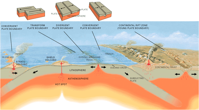 Figure 2. Plate boundaries types. (Image Source: USGS).
Mid-Atlantic Ridge
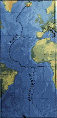 Figure 3. The Mid-Atlantic Ridge, which splits nearly the entire Atlantic Ocean north to south, is probably the best-known and most-studied example of a divergent plate boundary. (Image Source: USGS).
 Perhaps the best known of the divergent boundaries is the Mid-Atlantic Ridge. This submerged mountain range, which extends from the Arctic Ocean to beyond the southern tip of Africa, is but one segment of the global mid-ocean ridge system that encircles the Earth.
The rate of spreading along the Mid-Atlantic Ridge averages about 2.5 centimeters per year (cm/yr), or 25 kilometers in a million years. This rate may seem slow by human standards, but because this process has been going on for millions of years, it has resulted in plate movement of thousands of kilometers. Seafloor spreading over the past 100 to 200 million years has caused the Atlantic Ocean to grow from a tiny inlet of water between the continents of Europe, Africa, and the Americas into the vast ocean that exists today.
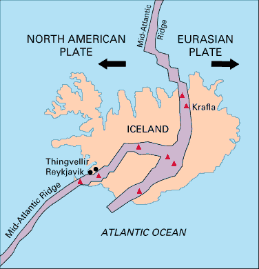 Figure 4. Map showing the Mid-Atlantic Ridge splitting Iceland and separating the North American and Eurasian Plates. The map also shows Reykjavik, the capital of Iceland, the Thingvellir area, and the locations of some of Iceland's active volcanoes (red triangles), including Krafla. (Image Source: USGS).
 The volcanic country of Iceland, which straddles the Mid-Atlantic Ridge, offers scientists a natural laboratory for studying on land the processes also occurring along the submerged parts of a spreading ridge. Iceland is splitting along the spreading center between the North American and Eurasian Plates, as North America moves westward relative to Eurasia.
The consequences of plate movement are easy to see around Krafla Volcano, in the northeastern part of Iceland. Here, existing ground cracks have widened and new ones appear every few months. From 1975 to 1984, numerous episodes of rifting (surface cracking) took place along the Krafla fissure zone. Some of these rifting events were accompanied by volcanic activity; the ground would gradually rise 1-2 meters before abruptly dropping, signalling an impending eruption. Between 1975 and 1984, the displacements caused by rifting totalled about 7 meters.
Global Mid-Ocean Ridge
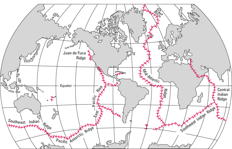 Figure 5. The mid-ocean ridge (shown in red) winds its way between the continents much like the seam on a baseball. (Image Source: USGS).
The major mid-ocean ridges are connevted as shown in Figure 5. This results in what can be considered. the greatest mountain range extending 64,374 kilometers (40,000 miles) from the Arctic Ocean to the Atlantic Ocean, around Africa, Asia, and Australia, and under the Pacific Ocean to the west coast of North America. It has a greatest height of 4207 meters (13,800 feet) above the base ocean depth.
Regional Mid-Ocean Ridges
The following list provides the names typically used for mid-ocean ridges around the world. There are two levels of bullets. The first level provide the names of the major mid-ocean ridges while the the indented bullets provide the names of sections of larger ridges under which they are listed (e.g., the Molloy Ridge is a section of the Mid-Atlantic Ridge). In addition a few notable "Triple Points" are given. These points mark the convergence of three mid-ocean ridges.
- Mid-Arctic Ridge
- Gakkel Ridge (1,800 kilometers from Greenland to Siberia)
- Mid-Atlantic Ridge
- Molloy Ridge (west of northern Svalbard)
- Vestnesa Ridge (west of Svalbard)
- Knipovich Ridge (~ 73.5°N, 8°E to Fram Strait west of Svalbard)
- Mohns Ridge (Jan Mayen Island to ~ 73.5°N, 8°E)
- Kolbeinsey Ridge (North of Iceland to Jan Mayen Island)
- Reykjanes Ridge (South of Iceland)
- Central Mid-Atlantic Ridge (south of 53°N)
- Azores-Gibraltar Ridge
- South-Central Mid Atlantic Ridge (8°N to the Azores)
- Southwest Indian Ridge (SW-NE, from the Bouvet Triple Junction to the Rodrigues Triple Junction)
- Central Indian Ridge or Mid-Indian Ridge (from from the Rodrigues Triple Junction north to the Owen Fracture zone)
- Carlsberg Ridge (northern portion of the Central Indian Ridge - SE-NW from 2°S to 10°N at Owen Fracture Zone)
- Gulf of Aden Ridge/Sheba Ridge (north and east of Owen Fracture zone)
- Southeast Indian Ridge (from the Rodrigues Triple Junction east across the Indian Ocean and south of Australia to join the Pacific-Antarctic Ridge)
- American-Antarctic Ridge (from east of the South Sandwich Islands across the south Atlantic to the Bouvet Triple Junction)
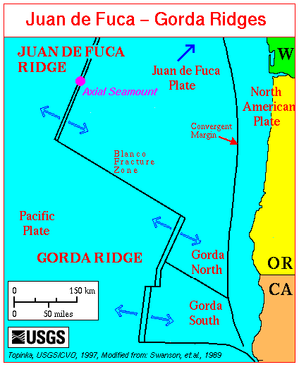 Juan de Fuca Ridge and Gorda Ridge
 - Juan de Fuca Ridge (approximately N-S for 500 kilometers parallel to the coast of the NW United States and western Canada)
- Gorda Ridge (extends north from the San Andreas fault of the northern California coast to the Blanco Fracture Zone off of the Oregon Coast)
- East Pacific Rise (approximately N-S parallel to the cosat of South America to the Gulf of California)
- Pacific-Antarctic Ridge (From south of New Zealand across the South pacific to join the East Pacific Rise)
- Cocos Ridge (from Costa Rica to Cocos Island to northern Galapagos Islands)
- Chile Rise (SE-NW from the East Pacific Rise near Easter Island to the Chile basin off the coast of Chile)
The Bouvet Triple Junction (55°S, 1°W) is the point where the Mid-Atlantic Ridge, the Southwest Indian Ridge, and the American-Antarctic Ridge
The' Rodrigues Triple 'Junction (25.5° S, 70° E) is the point where the Central Indian Ridge, the Southwest Indian Ridge and the Southeast Indian Ridge meet.
Further Reading
- Aleshire, P., Ocean Ridges and Trenches (The Extreme Earth), Chelsea House Publications, 2007), ISBN-10: 9780816059195
- Buck, W.R., Faulting and Magmatism at Mid-Ocean Ridges, Geophysical Monograph, American Geophysical Union, 1998,ISBN-10: 0875900895 Cann, J.R., Elderfield, H., Laughton, A.S. (editors), Mid-Ocean Ridges: Dynamics of Processes Associated with the Creation of New Oceanic Crust, Cambridge University Press, 1999,ISBN-10: 9780521585224
- Consortium for Oceanographic Activities for Students and Teachers, Deep Ocean Basins: Oceanic Ridges
- Hallar, K., Global and Regional Tectonics, USGS
- Macleod, C.J., Tyler, P.A., Walker, C.L. (editors), Tectonic, Magmatic, Hydrotherma, & Biological Segmentation at Mid-Ocean Ridges, Geological Society Special Publication, No. 118, 1996,ISBN-10: 9781897799727
- Phipps-Morgan, J., Blackman, D.K., Sinton, J.M. (editors), Mantle Flow and Melt Generation at Mid-Ocean Ridges, Geophysical Monograph, American Geophysical Union, No. 71, 1993, ISBN-10: 0875900356
- USGS, Earthquake Facts
- USGS, Earthquake Glossary - oceanic spreading ridge
- USGS, Earthquakes and Plate Tectonics
- USGS, This Dynamic Planet, The Story of Plate Tectonics
- Wilcock, W.S.D., Ridge Theoretical Institute of Subs., DeLong E.F., Kelley D.S., The Subseafloor Biosphere at Mid-Ocean Ridges, Geophysical Monograph, American Geophysical Union, 2004,ISBN-10: 087590409
3 Comments
Peter Saundry wrote: 11-27-2012 06:06:48
The key word in the question is "suddenly" - nothing happened "suddenly" but as Sasha indicates, ongoing tectonic processes drove the slow transition from the particular alignment of the continents known as Pangea to the alignment of the continents that exists today and continues to cause change.
sasha herod wrote: 11-24-2012 13:56:56
The splitting of Pangea was due to the same tectonic activities that are causing the plates to move along different boundaries today. all that is happening now have occurred in the past and will reoccur in the future its a cycle. so guess what? a couple millions of years from now the convection currents(driving force of plate tectonic) in the mantle will cause the plates to once again reunite then separate.splitting usually occur along line of weakness in the lithosphere enabling magma to penetrate tru rocks.
Jan Sapper wrote: 08-05-2011 11:14:50
Is there anybody who can tell me why "suddenly" pangea decided to split?