Marajó varzea
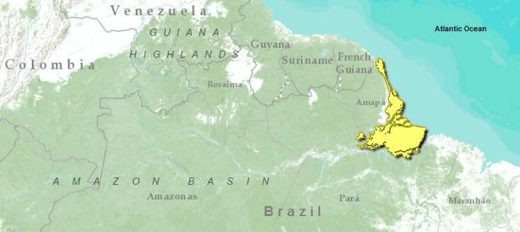
This forest ecoregion is located at the mouth of the Amazon River in eastern Brazil. Islands are numerous throughout the region. This flooded area captures nutrient rich soils, which are carried down the river; tidal activity floods the region twice daily. Vegetation is shorter than surrounding areas, plant diversity is lower, and palms dominate. Fauna diversity is richer; avifauna is particularly rich with about 540 species.
There are no protected areas in this ecoregion. Cattle and water buffalo ranching and large-scale commercial logging are the main threats to this ecoregion.
Contents
Location and General Description
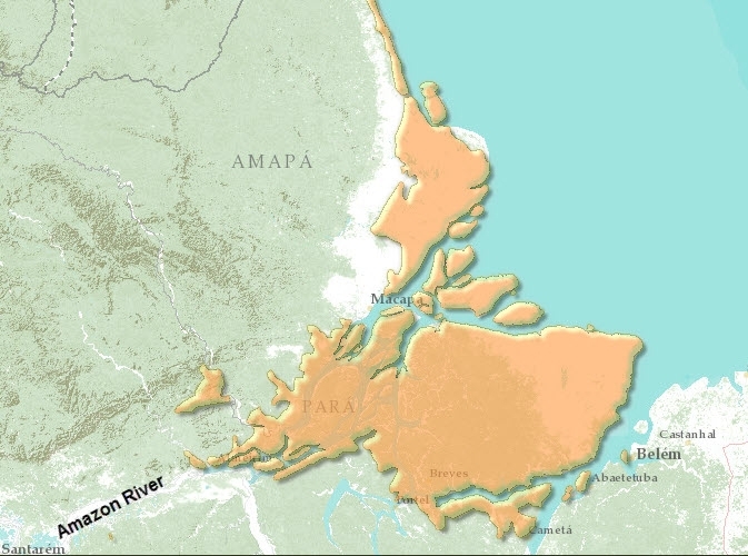
The Marajó várzea is the inundated land in and around the mouth of the Amazon River in eastern Brazil. The huge river, having completed its 6,500 kilometer (km) journey, empties into the Atlantic Ocean here. The mouth contains numerous islands. The largest is Ilha Marajó at 48,000 square kilometers (km2). Other islands include Ilha dos Porcos, do Pará, Mututí, and Uituquara. The Amazon estuary is a dynamic lowland consisting of Holocene (less than 10,000 years old) sediments surrounded by slightly older Tertiary deposits. Flooding occurs across the landscape twice daily when the ocean tide pushes a large volume of river discharge onto the landscape to a height of 2 to 3 meters (m). There are both low-lying tidal floodplain areas and slightly higher (2 to 3 m) ground that is not normally flooded.
The entire area is characterized by an abundance of poorly-drained heavy mottled clay soils . This type of várzea is different from the seasonal várzea of the middle and upper Amazon floodplains, which are inundated annually by [[river]s] swollen with rainwater. The floodwaters of the Amazon River are laden with suspended mineral sediments that settle out onto the landscape when the water flow slows. This area is called "region of the islands" because of the intricate labyrinth of sedimentary islands and channels resulting from the constant tidal and fluvial action.
This várzea ecoregion comprises the western half of Marajó Island, many smaller channel islands, and the surrounding mainland on both the north and south banks of the Amazon. The ecoregion reaches west to the mouth of the Xingú River where the Amazon starts to widen its mouth. A small portion occurs in French Guiana. The region also contains bits of both seasonally inundated floodplain forest and permanently inundated swamp forest (igapó). This western half of the Marajó Island is constructed of recent sediments and hosts the estuarine (tidal) várzea forest. The eastern half of Marajó island, on older Tertiary sediments, is covered by flooded savanna (campo) and humid terra firme forest, the forest being fairly homogeneous and distinct from the inundated forest in the west.
The várzea forest performs critical ecological functions such as capturing and rapidly cycling nutrients, hosting a great diversity of freshwater fish and aquatic mammals, stabilizing the flooded soils and landscapes, and perhaps providing a source of new taxa that colonize the surrounding terra firme.
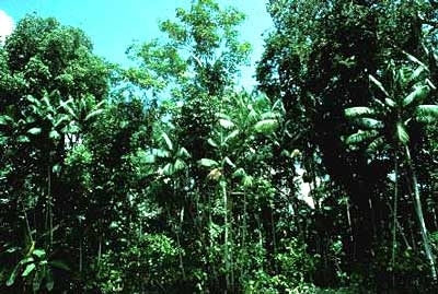
The flora is distinct from that on adjacent uplands. The varzea forest has a lower canopy, less species diversity, and a predominance of palms. The most abundant species of palms are Astrocaryum murumuru, Raphia taedigera, Euterpe oleracea, Maximiliana regia, Oenocarpus bacaba, Jessenia bataua, Mauritia flexuosa, Manicaria saccifera, Socratea exorrhiza, and various species of Geonoma. Large areas are dominated by pure stands of the economically important buriti palm Mauritia flexuosa and acai-palm Euterpe oleracea. Trees common to the tidal várzea include important timber species such as Virola surinamensis, Cedrelinga castanaeformis, Ceiba pentandra, Calycophyllum brasiliensis, and other species of large trees such as Ficus spp., Macrolobium acaciifolium, Pachira aquatica, Symphonia globulifera, Triplaris surinamensis, and Mora paraensis . On the banks of the [[river]s], the shrub Machaerium lanatum forms long, dense thickets. Sizable lianas grow in these flooded areas and include Strychnos blackii, Landolphia paraensis, and Guatteria scandens.
Biodiversity Features
On Marajó Island, there are 361 known species of birds, on Caviana Island 145, and on Mexican Island 189. The region as a whole contains a total of 540 species. There is a wide variety of aquatic birds including herons and egrets Egretta and Ardea, ducks Dendrocygna spp., ibis Cercibis spp., Theristicus spp., and rosette spoonbills Ajaia ajaia. Birds found here and in only few other places include white-bellied seedeaters Sporophila leucoptera, grassland yellow-finches Sicalis luteola, chalk-browed mockingbirds Mimus saturninus, tropical peewees Contopus cinereus, rufous-throated antbirds Gymnopithys rufigula, black-breasted puffbirds Notharchus pectoralis, and plain-bellied emeralds Amazilia leucogaster.
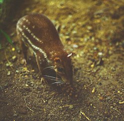
Scientists have reported 99 mammal species in this ecoregion. The short-tailed opossum Monodelphis maraxina is endemic and endangered. Other mammals that are found only in this ecoregion, or in few other places, include an armadillo Dasypus septemcinctus, bats (Platyrrhinus recifinus, Natalus stramineus, and Molossops greenhalli), primates such as marmosets (Callithrix argentatado), tamarins (Saguinus midas), night monkeys (Aotus infulatus), and savanna foxes (Cerdocyon thous). The endangered American manatee (Trichechus manatus) occurs here. Cats include jaguars (Panthera onca) and pumas (Puma concolor).
Very large fish live in the estuary, and they roam through the flooded forest eating and dispersing fruits from the floodplain trees. These fish include pacus (Metynnis and Mylossoma), tambaqui (Colossoma macropomum), pirarucus (Arapaima gigas), and sardinhas (Triportheus angulatus).
The buriti palm Mauritia flexuosa and other trees that produce large, fleshy, or mealy fruits provide an important source of food for animals that graze on the river bank, such as gray brocket deer (Mazama gouazoubira), red brocket deer (M. americana), and capybaras (Hydrochaeris hydrochaeris), the world’s largest rodents.
Current Status
The Marajó várzea, because it lies at the mouth of the Amazon’s "super highway," is a region greatly affected by human activities, both historically and in the present. Both the natural habitat and native biodiversity of the Marajó várzea have suffered severe degradation from large-scale agricultural, forestry, and ranching operations. There are no protected areas in this ecoregion.
Types and Severity of Threats
The most severe threat is human-induced habitat loss (Land-use and land-cover change). Crop production is only a minor source of deforestation of this region. The majority of degraded land is the result of cattle and water buffalo ranching. The degradation of the natural grasslands results from the replacement of the native grazers such as deer and tapir by domestic stocks. Large-scale commercial logging has occurred on and around Marajó Island since the 1950s, all but replacing certain valuable native species: Virola surinamensis, Carapa guianensis, Cedrela odorata, Ceiba pentandra, and Maquira coreaceae. Farmers are planting stands of Euterpe oleracea for the commercially valuable açaí fruits , replacing. naturally dense stands of the native buriti palm Mauritia flexuosa. As ranching activities expand, habitat for the aquatic rodents, capybaras, on flooded savannas and gallery forests is lost. The cattle compete for the aquatic vegetation, which is critical food source for capybaras and manatees. Other large mammals, as well as fruit-eating fish, have become rare or locally extinct in this region as a result of habitat destruction (Land-use and land-cover change) and loss of food sources, such as fruit trees.
Justification of Ecoregion Delineation
This seasonally inundated ecoregion forms the delta and mouth of the Solimões (Amazon) River, the riverine island of Marajó and surrounding islands, and extends northwards along the Atlantic coastline. Delineations follow the IBGE classification of "alluvial vegetation" in the northern and eastern portion, and follows the confines on the Solimões River and delta to the south and east. Several outliers are also group under this classification to the NW according to historic vegetation coverage and follow the linework of the IBGE classification for "secondary vegetation/agricultural activities". Portions in the north which abut to French Guiana were verified according to Granville. This ecoregion is distinct from all other surrounding vegetation by its seasonal inundation and subsequent species assemblages, and from other várzea by crystalline arc divisions which influence soil type.
Additional Information on this Ecoregion
- For a shorter summary of this entry, see the WWF WildWorld profile of this ecoregion.
- To see the species that live in this ecoregion, including images and threat levels, see the WWF Wildfinder description of this ecoregion.
- World Wildlife Fund Homepage
Further Reading
- Anderson, A. B., I. Mousasticoshvily Jr., and D. S. Macedo. 1999. Logging of Virola surinamensis in the Amazon floodplain: impacts and alternatives. Pages 119-133 in C. Padoch, M. Ayres, M. Pinedo-Vasquez, and A. Henderson, editors, Várzea: Diversity, development, and conservation in Amazonia's whitewater floodplains. New York, The New York Botanical Garden Press. ISBN: 0893274194.
- Daly, D. C., and J. D. Mitchell. 2000. Lowland vegetation of tropical South America. Pages 391-453 in D. L. Lentz, editor, Imperfect Balance: Landscape transformations in the Precolumbian Americas. New York, Columbia University Press.
- Daly, D.C., and G.T. Prance. 1989. Brazilian Amazon. Pages 401-426 in D.G. Campbell, and H.D. Hammond, editors. Floristic inventory of tropical countries. New York Botanical Garden, Bronx, New York, USA. ISBN: 0893273333
- Ducke, A., and G. A. Black. 1953. Phytogeographical notes on the Brazilian Amazon. Anais da Academia Brasileira de Ciências 25: 1-46.
- Fundação Instituto Brasilero de Geografia Estatástica-IBGE. 1993. Mapa de vegetação do
- Brasil. Map 1:5,000,000. Rio de Janeiro, Brazil.
- Granville, J. 1979. La Guayane - Planche 12 - Vegetation. Map 1:1,000,000. Atlas des Centre d'Etudes de Geographie Tropicale, Office de la Recherche Scientifique et Technique d'Outre-Mer, Cayenne, French Guiana.
- Hiraoka, M. 1999. Miriti (Mauritia flexuosa) palms and their uses and management among the ribeirinhos of the Amazon estuary. Pages 169-186 in C. Padoch, M. Ayres, M. Pinedo-Vasquez, and A. Henderson, editors, Changes in soil formation and vegetation on silt bars and backslopes of levees following intensive production of rice and jute. New York: The New York Botanical Garden Press.
- Pires, J. M., and G. T. Prance. 1985. The vegetation types of the Brazilian Amazon. Pages 109-145 in G. T. Prance and T. E. Lovejoy, editors, Key Environments: Amazonia. New York: Pergamon. ISBN: 0080307760
- Silva, J.M. C. 1998. Um método para o estabelecimento de áreas prioritárias para a conservação na Amazônia Legal. Report prepared for WWF-Brazil. 17 pp
| Disclaimer: This article is taken wholly from, or contains information that was originally published by, the World Wildlife Fund. Topic editors and authors for the Encyclopedia of Earth may have edited its content or added new information. The use of information from the World Wildlife Fund should not be construed as support for or endorsement by that organization for any new information added by EoE personnel, or for any editing of the original content. |


