Mana Pools National Park, Sapi and Chewore Safari Areas, Zimbabwe
Contents
- 1 IntroductionThe Mana Pools National Park and Sapi and Chewore Safari Areas (15°37'-16°25'S, 29°08'-30°20'E) are a World Heritage Site located in Zimbabwe (Mana Pools National Park, Sapi and Chewore Safari Areas, Zimbabwe) on the banks of the Zambezi, with great cliffs overhang the river and floodplains. The area is home to a remarkable concentration of wild animals, including elephants, buffalo, leopards and cheetahs. An important concentration of Nile crocodiles has also be found in the area.
- 2 Geographical location
- 3 Date and history of establishment
- 4 Area
- 5 Land tenure
- 6 Altitude
- 7 Physical features
- 8 Climate
- 9 Vegetation
- 10 Fauna
- 11 Cultural heritage
- 12 Local human population
- 13 Visitors and visitor facilities
- 14 Scientific research and facilities
- 15 Conservation value
- 16 Conservation management
- 17 IUCN management category
- 18 Further reading
IntroductionThe Mana Pools National Park and Sapi and Chewore Safari Areas (15°37'-16°25'S, 29°08'-30°20'E) are a World Heritage Site located in Zimbabwe (Mana Pools National Park, Sapi and Chewore Safari Areas, Zimbabwe) on the banks of the Zambezi, with great cliffs overhang the river and floodplains. The area is home to a remarkable concentration of wild animals, including elephants, buffalo, leopards and cheetahs. An important concentration of Nile crocodiles has also be found in the area.
Geographical location
The park is situated in northernmost Zimbabwe in the Zambezi Valley, 100 kilometers (km) downstream from Kariba Dam, on the south bank of the river opposite the Lower Zambezi National Park in Zambia: 15°37'-16°25'S, 29°08'-30°20'E.
Date and history of establishment
- 1955: Much of the area protected as a non-hunting area;
- 1963: Mana Pools Game Reserve established;
- 1964: Chewore, Sapi and Urungwe Safari Areas designated; 1968: Dande Safari Area designated;
- 1975: The National Park established and made public under the Parks and Wildlife Act.
Area
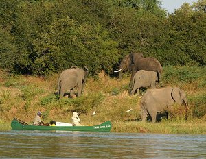 Mana Pools National Park, Sapi and Chewore Safari Areas, Zimbabwe (source: Wilderness Safaris)
 The park spans 676,600 hectares (ha).
Components:
- Mana Pools 219,600 ha
- Chewore 339,000 ha
- Sapi 118,000 ha
Contiguous conservation areas:
- Urungwe Safari Area 287,000 ha
- Dande Safari Area 52,300 ha
- Doma Safari Area 76,400 ha
Land tenure
Public ownership, in Urungwe district. Managed by the Zimbabwean Department of National Parks and Wildlife Management.
Altitude
Under 360 meters (m) to 1,244 m.
Physical features
The Mana Pools are former channels of the Zambezi which lie in its extensive valley 100-150 km below the Kariba Dam. There are four main pools: Main, Chine, Long and Chisambuk. The safari areas lie along the lower Zambezi River to near the Mozambique border except for Dande and Doma. Their hinterlands include large areas of the rugged Zambezi escarpment, which rises from the valley floor to 1,000 m. The geology of the region ranges from the recent river alluvia and Karoo sandstones to the ancient gneiss and paragneiss overlain by the lithosols of the basement complex of the escarpment. Much of Chewore is heavily dissected, with 30 km long Mupata Gorge along its northern boundary. Between the gorges of Kariba and Mupata, the river valley is broad and sandy.
Climate
The mean annual rainfall is 700 millimeters (mm), falling mainly in summer. The mean annual temperature is 25°C.
Vegetation
Well-grassed Brachystegia communities dominate the mountainous escarpment and higher Chewore areas. The valley floor is dominated by mopane Colophospermum mopane woodlands or dry highly deciduous thickets known as jesse. Seasonal tributaries crossing the valley floor support extensive riparian communities differing in character from the floodplain communities. On the younger sandier [[alluvia]l deposits] along the Zambezi are well-developed tracts of winterthorn Faidherbia albida with more diverse woodlands containing sausage tree Kigelia africana and Natal mahogany Trichilia emetica on the higher deposits of levées or old islands.
Fauna
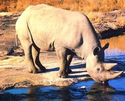 The WWF says that in east and southern Africa, black rhino numbers have dropped to fewer than 2,500 - a decline of more than 95% since 1970 (Source: American University)
 The rich and varied mammal populations concentrate on the floodplains during the dry season when water elsewhere is scarce, except in the escarpment, and when the numerous winterthorn trees shed their protein-rich pods. Chewore used to include a population of some 500 black rhinoceros Diceros bicornis (CR), the greatest concentration in Africa, but these have been poached out of existence. The fauna includes elephant Loxodonta africana (EN) which number in thousands, hippopotamus Hippopotamus amphibius, lion Panthera leo (VU), leopard P. pardus, cheetah Acinonyx jubatus (VU), wild dog Lycaon pictus (EN), spotted hyena Crocuta crocuta, honey badger Mellivora capensis, warthog Phacochoerus aethiopicus, bushpig Potamochoerus porcus, plains zebra Equus burchelli, and many antelopes including mixed herds of greater kudu Tragelaphus strepsiceros, bushbuck T. scriptus, nyala T. angasi, eland Taurotragus oryx, waterbuck Kobus ellipsiprymnus, sable antelope Hippotragus niger, grysbok Raphicerus melanotis, and steenbok R. campestris. Nile crocodile Crocodylus niloticus are numerous. Birdlife on the river and in the bush is prolific with over 380 species recorded including Nyasa lovebird Agapornis lilianae, yellow-spotted nicator Nicator chloris, rock pratincole Glareola nuchalis, banded snake-eagle Circaetus cinerascens, and Livingstone's flycatcher Erythrocercus livingstonei. Common fish include tiger fish Hydrocynus vittatus, bream Tilapia spp., vundu Heterobranchus longifilis, nkupi Distichodus mossambicus, chessa D. schenga, cornish jack Mormyropsanguilloides, and lungfish Protopterus annectens.
Cultural heritage
Iron Age sites have been investigated in the area and J. White has written on the history and customs of the Urungwe district.
Local human population
There is virtually no permanent human habitation because of the presence of an array of tropical diseases (Diseases and development challenges in Africa) including sleeping sickness, bilharzia, and malaria, but the main road between Harare and Lusaka with its associated settlements passes near the area.
Visitors and visitor facilities
During the dry season visitors here experience some of the highest concentrations of game in Africa and the greatest of all seasonal aggregations of wild mammals along the Zambezi river. There are high quality recreational hunting and angling and exceptional wildlife viewing which are all managed so as to impair neither these resources nor the wilderness. Mana Pools is only partially developed as a tourist center, but is so popular that the available facilities can become overcrowded. The number of cars allowed into the National Park at one time is limited. There are tourist camps at Rukumeche in the west and at Chikwenya at the confluence of the Sapi and Zambezi rivers, but there are no tarred roads and visitor movements are strictly confined. Visitors are allowed to walk in the riparian woodlands in the park. During the wet season the area is virtually closed and the only effective way to see it is by canoe. However, current conditions in the country may affect tourism.
Scientific research and facilities
Scientific research and education is conducted on ecological stability and man's impact on the environment: long term studies have been made of the ecological effects of land-use systems applied in neighboring areas and the effects on riparian communities of the formation of Lake Kariba. Regular aerial game counts are carried out. A research laboratory is located at Mana Pools. An ecologist and workers were stationed in the area after a break of several years but foreign researchers are not granted visas to work there at present.
Conservation value
Cliffs overhanging the river and floodplains harbor a remarkable density of wild animals including elephants, buffaloes, leopards, cheetahs and large numbers of Nile crocodiles and birds.
Conservation management
 Zambezi River (Source: FAO)
 Fully protected, but strictly controlled recreational hunting is permitted in the safari areas. Chewore and Sapi are eventually to become National Parks. The five areas are zoned into: Special Conservation Areas with no development and entry only for scientific purposes; Wilderness Areas of sufficient size to contain the complete biota of the locality and bearing few signs of human occupation; Wild Areas serviced by roads and tracks, but where the fauna and flora are paramount; and Development Areas for visitor, management and administrative facilities. Hunting rights in Sapi, Chewore and part of Urungwe are divided into lots which are sold by auction on an annual basis; in the rest of Urungwe they are sold to a local hunting association, and in Dande they are leased to a safari company.
Management constraints
Natural seasonal flooding of low-lying areas was seriously curtailed by the completion of Kariba Dam in 1958. In 1989, oil exploration was proposed in the reserves using trace line roads which would result in erosion, industrial littering and improved access for poachers. International publicity temporarily averted this threat. The ecological heart of the area, the rich floodplain, has been further threatened by a hydroelectric scheme proposed for Mapata Gorge which would create a 85,000 ha lake, obliterating much of the Zambezi valley and halving the carrying capacity of Mana Pools. An environmental assessment has been completed.
When the property was listed in 1984, it contained about 500 black rhinoceros, the largest endemic population of these animals in Africa. But this was almost destroyed by well organized foreign poachers, chiefly from across the river in Zambia who killed many rangers. To help control the problem it was suggested in 1987 that the site be listed in danger and that Lower Zambezi National Park in Zambia be added to the World Heritage Site. But at the end of 1994 the last ten rhino were captured and translocated to an intensive protection zone in another part of Zimbabwe. Habitat destruction by elephants is also a problem. Other problems include poaching of elephants and fish. The main road between Harare and Lusaka with associated settlements passes through the area and there is a private estate on the Zambezi near Chirundu. The land is of limited agricultural potential and has never been used extensively for livestock grazing owing to tsetse fly infestation. Conditions in the country are said to have led to much destruction of wildlife during the past two years although Mana Pools are remote enough to be relatively unaffected.
Staff
The complex is administered by a Chief Warden at Marangora and head wardens for each of the safari areas, with seven rangers, support staff, one ecologist and his junior staff.
Budget
No information is available.
IUCN management category
- II (National Park)
- Natural World Heritage Site inscribed in 1984. Natural Criteria ii, iii, iv
Further reading
Numerous National Parks and Wildlife Management departmental reports are augmented by published papers on the biology of the area and include a population census as a basis for setting hunting quotas.
- Barkham, J. (1981). Report on the Environmental Impact Assessment of Proposed Hydro-electric Schemes on the Zambezi River. IUCN, Gland. 30 pp.
- David Shepherd Wildlife Foundation (2003). Africa's drought kills wildlife too. Wildlife Matters. 1p.
- du Toit, R. (1982). A Preliminary Assessment of the Environmental Implications of the Proposed Mupata and Batoka Hydro-electric Schemes (Zambezi River, Zimbabwe). Natural Resources Board, Harare. 209 pp.
- Guy, P. (1977). Notes on the vegetation types of the Zambezi Valley, Rhodesia between Kariba and Mupata Gorges. Kirkia 10: 543-557.
- Jarman, P. (1972). Seasonal distribution of large mammal populations in the unflooded middle Zambezi Valley. Journal of Applied Ecology 9: 283-299.
- Policy document covering the five areas (24 February 1981).
- Raath, J. (1989). Mobil threatens Zimbabwe's wildlife. China Daily. 26 May.
- White, J.(1974). Some notes on the history and customs of the Urungwe District. Native Affairs Dept. Ann., Rhodesia 10(3):33-72.
| Disclaimer: This article is taken wholly from, or contains information that was originally published by, the United Nations Environment Programme-World Conservation Monitoring Centre (UNEP-WCMC). Topic editors and authors for the Encyclopedia of Earth may have edited its content or added new information. The use of information from the United Nations Environment Programme-World Conservation Monitoring Centre (UNEP-WCMC) should not be construed as support for or endorsement by that organization for any new information added by EoE personnel, or for any editing of the original content. |
1 Comment
Peter Howard wrote: 02-02-2011 20:22:04
Readers may want to visit the African Natural Heritage website to view a selection of images and map of the Mana Pools National Park world heritage site, and follow links to Google Earth and other relevant web resources: http://www.africannaturalheritage.org/Mana-Pools-Zimbabwe.html