Magdalena Valley dry forests
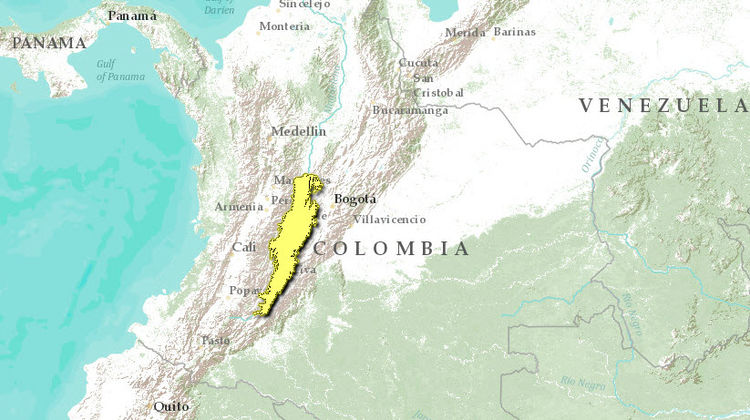
This ecoregion, located within the Northern Andes, occurs along the dry inter-Andean valley formed by the Magdalena River, which is the largest in Colombia. The climate is dry and vegetation includes cati such as Armathocereus humilis and Stenocereus griseus. Fauna biodiversity is relatively unknown, but includes a few endemic subspecies such as the burrowing owl (Athene cunicularia tolimae), tropical bobwhite (Colinus cristatus leucotis), and euphonia (Euphonia concinna). Agriculture, and overgrazing, especially from introduced goats, has destroyed much of the original habitat. Major conservation plans are needed to save this ecoregion since there are no national parks.
Location and General Description
This inter-Andean valley is located between the Eastern and Central cordilleras of the Northern Andes in Colombia, and it is dissected by the Magdalena River, the largest Colombian western river; the basin arises in the Central Massif or Macizo Colombiano, and flowing northwards to the Caribbean sea, the Magdalena crosses several kinds of ecosystems: in its upper part the dry forest, in its middle course the Magdalena Medio rain forest, and in its lower course the swamps and wetlands of the Caribbean lowlands.
The dry forest are located between 2° and 5° north and 74° 30’ and 75° 30’ west, with a mean altitude of 450 meters (m) above sea level (masl). The climate is dry, with rainfall of no more than 1000 millimeters (mm) per year; the rainy season are between April and July and another between October and December.
The bottom of the valley is completely flat, and the soils are of alluvial origin with large depositions of volcanic ashes from surrounding Huila and Puracé volcanoes, and are considered as very good for agriculture. The Tatacoa Desert, located in the middle of the upper course, gets less than 700 mm of rain per year and has thorny vegetation. Around this dry pocket the rainfall increases towards the upper [[and the vegetation changes to [../154714/index.html mountain]] cloud forests and páramos above 2800 masl. The Tatacoa is an important depository of vertebrate fossils dating from the Miocene.
The thorny vegetation in the dry pocket is composed mainly of several cacti, such as Opuntia spp., Melocactus spp., Armathocereus humilis, Stenocereus griseus, Acanthocereus pentagonus y Pilosocereus colombianus; and woody species of bushes and trees such as Pithecellobium bogotense, Capparis odoratissima, Bulnesia carrapo, Maclura tinctoria, Fagara pterota, Prakinsonia aculeta, Prosopis juliflora, and Acacia farnesiana among others. These trees usually are no more than fifteen meters (m) in height, and have a characteristic umbrella shape.
There are several plants species endemic to this area, specially Steriphoma colombiana, Amaria petiolata, Pithecellobium bogotense and in the transition forests between dry and moist regions, the national flower of Colombia, the endemic and highly endangered Cattleya trianaei.
Biodiversity Features
Very little is known about the biodiversity of this region; endemic species are: the burrowing owl (Athene cunicularia tolimae), the tropical bobwhite (Colinus cristatus leucotis), the euphonia Euphonia concinna, the tropical cottontail rabbit (Sylvilagus floridanus purgatus) and the national flower of Colombia, the Christmas orchid Cattleya trianaei.
Besides the dry pocket, the surrounding forests are considered to be part of the Alto Magdalena pleistocenic refuge, also a paleo-environment and a center of endemism. Many other bird species and also orchids, butterflies and other plant families have endemic species to the Upper Magdalena. The dry pocket is believed to have played an important role as an arid corridor between the Caribbean coast and the upper Magdalena during the Pleistocene; the presence of such species as the bobwhite and the tropical rattlesnake (Crotalus durissus) confirm this.
The region is a place of arrival of many migratory birds, especially Thraupidae, Parulidae and Accipitridae. The osprey, Pandion haliaetus, also arrives to this region during the winter months in the north. Also, altitudinal migrations, from the upper mountains, have been recorded here, specially with some parrots and hummingbirds species. The rare and highly endangered yellow eared parrot Ognorhynchus icterotis was rediscovered around this region after many years of thought to have become extinct. The blue-billed curassow Crax alberti, is extinct in the region of the upper Magdalena.
Restricted range species include several cacti, including Armathocereus humilis and Melocactus spp., the endemic tree Pithecellobium bogotense, and the endangered tropical rattle snake Crotalus durissus.
From the humid forests in the foothills, there are several endemic or endangered species that need attention: Yellow eared parrot Ognorhynchus icterotis, Colombian weasel Mustela felipei, Christmas orchid Cattleya trianaei, and the tropical walnut Juglans neotropica.
Current Status
Today, most of the original forest cover has disappeared due to conversion of these to farmland and cattle-ranching. Only few forest patches still present around the Cabrera river in Tolima and along creeks. Goats were introduced since the XVI century by the Spanish, and their descendants are still roaming today on the vegetation left.
Types and Severity of Threats
Several oil deposits are present in the region, and the drilling and extraction of it is a cause of pollution around the Tatacoa desert.
Justification of Ecoregion Delineation
This dry inter-Andean valley in western central Colombia is flanked by both the Cordillera Oriental (to the east) and the Cordillera Central (to the west) of the northern Andes. Because of its isolation from similar [[habitat]s], a number a endemic species persist. Delineation for this ecoregion did not follow vegetation maps as in other areas, and instead relied exclusively on expert opinion from ecoregion priority setting workshops, and the marked elevational limits to dry forests based on the rain (cloud) shadow effect.
Further Reading
- Complejo Ecoregional de los Andes del Norte (CEAN). Experts and ecoregional priority setting workshop. Bogota, Colombia, 24-26, July, 2000.
- Hernández-Camacho, Jorge, and Sánchez Heliodoro. 1992. Biomas Terrestres de Colombia, en Gonzalo Halffter, editor, La Diversidad Biológica de Iberoamérica. México: Acta Zoológica Mexicana, CYTED-D.
- Hernández-Camacho, Jorge. 1995. Desiertos, Zonas Áridas y Semi-Áridas de Colombia. Colombia: Diego Samper Ediciones, Banco de Occidente.
| Disclaimer: This article is taken wholly from, or contains information that was originally published by, the World Wildlife Fund. Topic editors and authors for the Encyclopedia of Earth may have edited its content or added new information. The use of information from the World Wildlife Fund should not be construed as support for or endorsement by that organization for any new information added by EoE personnel, or for any editing of the original content. |

