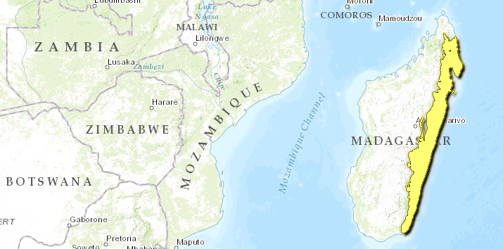
Madagascar lowland forests
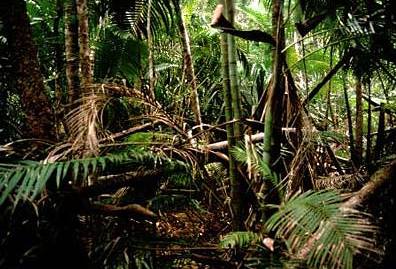
Analameiana, Madagascar. Source: WWF/ David M. Meyers
The Madagascar lowland forests include a narrow strip of humid forests along the east coast of Madagascar, low-elevation forests (from sea level up to 800 metres). Madagascar, the fourth largest island in the world, has been isolated for 150 to 180 million years from any continental landmass. This prolonged isolation is the major factor that led to extremely high levels of endemism of plant and animal species. Endemism within the island is approximately 80 to 90 percent for all groups, and endemic families and genera are commonplace. It is estimated that 85 percent of the island's 12,000 species of flowering plants are found nowhere else in the world. This unique biodiversity has led to the recognition of Madagascar, which is roughly twice the size of Arizona, as a "living laboratory" and the "seventh continent". Since humans arrived in Madagascar approximately 2000 years ago over 90 percent of the original forest cover has disappeared, mostly due to forest destruction by indigenous peoples, and forest destruction continues at a rapid pace. This means that virtually all the unique habitats and endemic animals of Madagascar face significant threats. It now has the greatest number of critically endangered primates of any country in the world.
The moist forests located along the eastern escarpment and coastal plain of the island have long been recognized as a particularly important center of endemism and diversity. Hundreds of species of vertebrate animals and perhaps thousands of species of plants are strictly endemic to this ecoregion. These include a high diversity of mammals, especially lemurs. These forests are also home to the recently rediscovered Madagascar serpent eagle (Eutriochis astur), the Hairy-eared dwarf lemur (Allocebus trichotis) and the recently described Golden bamboo lemur (Hapalemur aureus), indicating that information on the biota of this ecoregion is far from being complete. These forests are also among the most threatened habitats in the world due to rapid clearance by the shifting cultivation practiced by local people.
This ecoregion is an important part of the Madagascar and the Indian Ocean Islands biodiversity hotspot. Dominated by the nation of Madagascar, the fourth largest island on Earth, the hotspot also includes the independent nations of Seychelles (including Aldabra), the Comoros, Mauritius (including Rodrigues), and the French overseas departments of Réunion, Mayotte (one of the Comoros) and the Iles Esparses around Madagascar in the Indian Ocean.
Location and general description
These lowland forests extend from Marojejy in the north to the extreme southeastern corner of the island. At the northern edge of the ecoregion, around Vohémar, the moist forest changes to a transitional dry forest. This area has localized climatic conditions that lead to different vegetation, one of many such patches across Madagascar. At the ecoregion's southern limit, in the rainshadow of the Anosyennes Mountains, the moist forest changes in a very short distance from a dry transitional forest to spiny forest. At the ecoregion's western edge, the forest grades into subhumid forests around the 800 m contour on the central highlands.
Rainfall is generally over 2000 mm per year throughout the ecoregion. In some areas, such as the Masoala Peninsula, it can be as high as 6000 mm per year. There is a slightly cooler and drier period between May and September. Cyclones occur in some years between November and March, and they can cause considerable habitat destruction. The mean annual temperature in the forest is 26 °C.
Most of this ecoregion is underlain by metamorphic and igneous basement rock. There are patches of marble and quartz north of the Antongil Bay. There is also an eastern lowland belt of lava and a narrow coastal plain of unconsolidated sands. In general, the geology along the eastern length of the island is relatively homogeneous, and vegetational composition and structure vary more with elevation than with latitude.
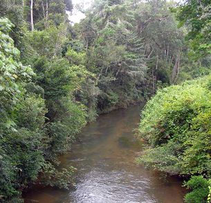 Riparian rainforest scene, Toamasina Province. Source: C.Michael Hogan The ecoregion includes moist forests across an elevational range from sea level to around 800 metres (m). There is ongoing research and discussion on the divisions of forest types throughout these eastern forests. Generally, vegetation of this eastern region has been divided into three primary categories corresponding to broad elevational bands: "lowland rainforest" (zero to 800 metres), "moist montane forest" (800 to 1300 metres), and "sclerophyllous montane forest" (1300 to about 2300 metres). The first of these categories is placed in the lowland forest ecoregion and the latter two in the subhumid forest ecoregion. Local conditions can result in deviation from these generalizations. In fact, in many areas, the transition from lowland to montane forest may be closer to the 600 m contour. While it is clear that animal and plant species change significantly with elevation, the transition between low elevation and mid-elevation forest is relatively gradual across the complete latitudinal range of eastern Madagascar.
There are some general trends in forest characteristics with increasing elevation: decreasing stature, fewer straight unbranched and boled trees, less stratification, more epiphytes, more bryophytes and lichens, a better developed and more diverse herb layer, and floristic changes. Dense evergreen trees characterize the lowland forest up to 800 m, with a canopy exceeding 30 m, and taller emergents such as Canarium (Burseraceae), Albizia (Fabaceae), and Brochoneura acuminata (Myristaceae). The lowland forest is typified by plants from the following genera and families: Diospyros (Ebenaceae), Ocotea (Lauraceae), Symphonia (Guttiferae), Tambourissa (Monimiaceae), and Dalbergia (Leguminosae).
The mid-altitude moist forest is as rich in species as the lowland forest, but tends to have a lower canopy of 20 to 25 metres. Some of the canopy species are common to the lower-elevation forest and some are unique to mid-elevation forest such as the Weinmannia (Cunoniaceae) and Schefflera (Araliaceae). The shrub and herb layers of the mid-elevation forests include Compositae, Rubiaceae and Myrsinaceae. One distinctive feature of this forest is the diversity of Pandanus species (Pandanaceae), bamboos (Graminaceae) and epiphytic plants.
The distribution patterns of some faunal groups differ from those of the flora within the eastern forests, in that faunal patterns vary with elevation and show less latitudinal homogeneity. This is illustrated by the distribution of the five subspecies of the lemur Eulemur fulvus and three subspecies of another lemur Propithecus diadema within the eastern moist forest. The important delineation diagnostics for the distributions of these subspecies are the major rivers flowing from the Central Highlands to the east, such as the Mangoro and Mananara.
Biodiversity features
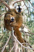 Red-fronted brown lemur (Eulemur fulvus rufus), Madagascar. Source: Duke University Primate Center, Durham, NC
 The moist forests of eastern Madagascar are the most diverse forests in the country, and contain exceptionally high levels of endemism. As with many other areas of Madagascar, there is little detailed information on many species within the eastern forests. The number and distribution of species is also continually changing as new research is completed.
There are many examples of rare animal species with restricted ranges in this ecoregion, such as the red-tailed newtonia (Newtonia fanovanae) or the brown-tailed mongoose (Salanoia concolor). Other notable species such as the Malagasy tomato frog (Dyscophus antongili) and the ruffed lemur (Varecia variegata rubra) are restricted to the area around the Masoala Peninsula. The golden bamboo lemur and the greater bamboo lemur are endangered primates that are restricted to relatively small patches of habitat that include primary moist forests with bamboo stands.
Mammals
The diversity of the forest mammalian fauna includes all five families of Malagasy primates, seven endemic genera of Rodentia, six endemic genera of Carnivora, as well as several species of Chiroptera. All five families of lemurs are represented in the eastern forests, with fifteen endemic and near-endemic species. These species include the Aye-aye (Daubentonia madagascariensis), recently rediscovered Hairy-eared dwarf lemur (Allocebus trichotis), two subspecies of ruffed lemurs (Varecia veriegata variegata, V. v. rubra), indri (Indri indri), Eastern woolly lemur (Avahi laniger), diademed sifaka (Propithecus diadema diadema), Milne-Edwards' sifaka (P. d. edwardsi), Silky sifaka (P. d. candidus), Golden bamboo lemur (Hapalemur aureus), Greater bamboo lemur (H. simus), White-collared lemur (Eulemur fulvus albocollaris), Collared lemur (E. f. collaris), and Red-bellied rubriventer (E. rubriventer). The mammalian fauna is also highly threatened. Out of 25 endemic and near-endemic species, 22 are threatened: eight as critically endangered; nine as endangered; and five as vulnerable.
Birdlife
The region harbors the greatest diversity of birds in Madagascar. Of the 165 breeding species recorded in the eastern forests, 42 are found nowhere else. Many of the species belong to the endemic families or subfamilies Mesitornithidae, Brachypteraciidae, Philepittinae, Vangidae, Bernieridae, and Couinae. In addition, thirteen genera are represented solely in this region, which comprise some of the rarest birds in the world. Two examples of Malagasy endemics include the Madagascar serpent eagle (Eutriorchis astur) and the Madagascar red owl (Tyto soumagnei), which have recently been rediscovered in several areas across this zone, including the Masoala Peninsula and sites further south.
The snail-eating coua (Coua delalandei), a lowland forest species from the endemic subfamily Couinae, was last recorded in 1834 and is almost certainly extinct. All specimens of this species with precise locality information come from the nearby offshore island of Isle Sainte Marie.
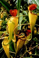 Pitcher plant, Nepenthes madagascariensis, Madagascar. Source: David Olson Reptiles and amphibians
In summary, about 50 species of reptiles, 29 species of amphibians, and probably more than 100 endemic species of freshwater fish, many of which are severely threatened, are strictly endemic to the Madagascar lowland forest ecoregion.
Flora
The plant diversity and endemism in the eastern forests is regarded as extremely high, with 82 percent specific endemism. For example, 97 percent of the 171 species of Malagasy palms (e.g. Dypsis, Neophloga) are endemic to the island, with a majority found in the eastern forests. Orchids (Orchidaceae) are also abundant, with many confined to these eastern forests. One of the most famous is the Angraeceum sesquipedale with a 35 cm spur that has evolved in tandem with its pollinator, a species of sphinx moth with a 30 cm long tongue.
Ecological status
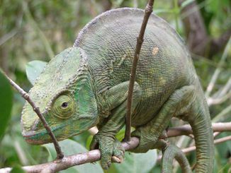 Parson's chameleon, eastern Madagascar rainforest. Source: C. Michael Hogan The forested habitats of this ecoregion have been very heavily degraded and fragmented, so that most natural habitat has already disappeared decades ago. The process of deforestation has been going on for centuries and now, with increasing population and decreasing forest cover, there is intense pressure on the remaining forests. Recent estimates of the remaining forest cover vary. This is due, in part, to the difference in classification used by different scientists. Du Puy and Moat estimated that 33,000 km2 of lowland forest and 32,500 km2 of mid-elevation forest remains.
A significant proportion of the forest cover has been totally removed in the lowlands of the southern and eastern parts of the ecoregion, and several remaining stands of this forest type are isolated from each other. In only a few locations (e.g., Masoala Peninsula), do the forests extend continuously through significant elevational gradients starting at sea-level. There are also only a few large blocks of lowland habitat remaining in the ecoregion, for example in the northeast on the Masoala Peninsula and northeast of Toamasina around the Mananara Biosphere Reserve. Many of the remaining large blocks are found in protected areas, such as Masoala National Park, Mananara Biosphere Reserve (including Verezanantsoro National Park), Ambatovaky Special Reserve, and Zahamena Integral Nature Reserve and National Park. However, significant areas of lowland forest occur outside of protected areas and include such zones as the forests near Rantabe in the northeast and the eastern slopes of the northern Vohimena Mountains in the southeast.
Du Puy and Moat suggest that seven percent of the remaining forests (see above for area) are "well protected" in some form of reserve, while 27 percent of the remaining forests are poorly protected in forest concessions and forest reserves. Integral nature reserves, national parks and special reserves may not be succeeding at some sites in protecting forests due to lack of logistic and financial resources, poorly marked and managed boundaries,inadequately trained staff and increasing pressure from farming communities around the reserves. The forest reserves and concessions exist primarily for forest exploitation by native peoples, and few reserves have management plans.
Ecological threats
The major threat to the Madagascar lowland forests is presently, as it has been historically, the shifting cultivation practise of "tavy," or slash-and-burn agriculture. The forest is cut and burned to grow crops such as manioc and hill rice. After two to three years, the land is typically abandoned, regenerating into bushland and thicket. Ideally from the standpoint of agriculture, after more than ten years the land can be used again for agricultural crops. Due to increasing population pressure, fallow periods have become shorter. In some areas, the land has become degraded to the point where crops cannot be planted, and it becomes secondary grassland or is simply invaded by weeds, such as bracken (Pteridium). A reduction of the farming fallow period has led to lower crop yields and further pressure on the forests, as they are the only source of new farmlands.
Secondary threats to the forest include unintentional burning from wildfires as well as legal and illegal commercial logging. In some areas, over-exploitation of selected forest species for decorative purposes, such as palms and Cyathea tree ferns, can critically undermine the forest's integrity. Given the established agricultural practices and increasing human population, damage to the natural resources of the remaining eastern forests will continue. The risk of extinction of numerous narrowly endemic species over the next few decades cannot be underestimated in this ecoregion.
Justification of ecoregion delineation
This ecoregion is based on Cornet's humid bioclimatic division, which also corresponds to Humbert's Eastern domain. It runs along the length of Madagascar's east coast, with the inland boundary delineated roughly at the 800 m contour. This includes a narrow strip (one to five km wide) of littoral forest that runs along portions of the coast, and contains a high number of endemic species. The Madagascar lowland forests is accorded the ecocode AT0117 by the World Wildlife Fund.
Neighbouring ecoregions
The following ecoregions have some tangency to the Madagascar lowland forests:
- Madagascar subhumid forests, to the east and north
- Madagascar spiny thickets, at the extreme southwest tip
References
- COEFOR/CI, 1993. Répertoire et Carte de Distribution: Domaine Forestier de Madgascar. Direction des Eaux et Forets, Service des Ressources Forestières, Projet COEFOR (Contribution a l' étude des forêts classés), et Conservation International, 20p + 1 map.
- Cornet, A. 1974. Essai cartographique bioclimatique à Madagascar, carte à 1/2'000'000 et notice explicative N° 55. ORSTROM, Paris.
- Dransfield, J. and H. Beentje. 1995. The palms of Madagascar. Royal Botanic Gardens, Kew London, UK. xii+475p. ISBN: 0947643826
- Du Puy, D. J. and J. Moat. 1996. A refined classification of the primary vegetation of Madagascar based on the underlying geology: using GIS to map its distribution and to assess its conservation status. In W. R. Lourenço (editor). Biogéographie de Madagascar, pp. 205-218, + 3 maps. Editions de l' ORSTOM, Paris. ISBN: 2709913240
- Goodman S. M., editor. 1996. A Floral and Faunal Inventory of the Eastern Slopes of the Réserve Naturelle Intégrale d' Andringitra, Madagascar: with reference to elevational variation. Fieldiana: Zoology, new series, 85: 1-319.
- Goodman S. M., editor. 1999. A Floral and Faunal Inventory of the of the Réserve Naturelle Intégrale d' Andohahela, Madagascar: with reference to elevational variation. Fieldiana: Zoology, new series, 94: 1-297. ISBN: 9990896747
- Goodman S. M., editor. 2000. A Floral and Faunal Inventory of the Parc National de Marojejy, Madagascar: with reference to elevational variation. Fieldiana: Zoology, new series, 97: 1-286.
- Harcourt, C., editor. 1990. Lemurs of Madagascar and the Comores. IUCN Red Data Book, IUCN, Gland. ISBN: 2880329574
- Hilton-Taylor, C. 2000. 2000 IUCN Red List of Threatened Species. IUCN, Gland, Switzerland and Cambridge, United Kingdom. ISBN: 2831705657
- Humbert, H. 1955. Les territoires phytogéographiques de Madagascar. In: Colloques internationaux du C.N.R.S., 59: Les divisions écologique du Monde. Moyen d' expression, nomenclature, cartographie. Paris, juin-juillet 1954. Année biologique, 3e sér. 31: 439-448.
- Humbert, H. 1959. Origines présumées et affinités de la flore de Madagascar. Mém. Inst. Sci. Mad. Sér. B (Bio. Vég.), 9: 149-187.
- Jolly, A., P. Oberlé, and R. Albignac. 1984. Key Environments: Madagascar. Pergamon Press, Oxford. ISBN: 0080280021
- Kremen, C. in press. The Masoala Peninsula in S. M. Goodman and J. P. Benstead, editors. The Natural History of Madagascar. The University of Chicago Press, Chicago. ISBN: 0226303071
- Langrand, O. 1990. Guide to the Birds of Madagascar. Yale University Press, New Haven. ISBN: 0300043104
- Lewis, B. A., P. B. Phillipson, M. Andrianarisata, G. Rahajasoa, P.J. Rakotomalaza, M. Randriambolona, and J.F. McDonagh. 1996. A study of the Botanical Structure, Composition, and Diversity of the Eastern Slopes of the Réserve Naturelle Intégrale d' Andringitra, Madagascar in S. M. Goodman (ed). A floral and Faunal Inventory of the Eastern Slopes of the Réserve Naturelle Intégrale d' Andringitra, Madagascar: with reference to elevational variation. Fieldiana: Zoology, new series, 85: 24-75.
- Lourenço, W. R., editor. 1996. Biogéographie de Madagascar. Paris, ORSTOM. ISBN: 2709913240
- Lourenço, W. R. and S. M. Goodman, editors. 2000. Diversité et Endémisme à Madagascar. Mémoires de la Société de Biogéographie, Paris.
- Lowry, P. P. II, G. E. Schatz, and P. B. Phillipson. 1997. The classification of natural and anthropogenic vegetation in Madagascar. Pages 93-123. In S. M. Goodman and B. D. Patterson, editors. Natural change and human impact in Madagascar. Smithsonian Institution Press, Washington, D.C. ISBN: 1560986832
- Mittermeier, R. A., N. Myers, P. R. Gil, and C.G. Mittermeier. 1999. Hotspots: earth's biologically richest and most endangered terrestrial ecoregions. CEMEX, Conservation International and Agrupacion Sierra Madre, Monterrey, Mexico. ISBN: 9686397582
- Mittermeier, R. A., I. Tattersall, W. R. Konstant, D. M. Meyers, and R. B. Mast. 1994. Lemurs of Madagascar. Conservation International, Washington, D.C. ISBN: 1881173089
- Nelson, R. and N. Horning. 1993. AVHRR-LAC estimates of forest area in Madagascar, 1990. International Journal of Remote Sensing 14(8):1463-1475.
- Nicoll, M. E. and O. Langrand. 1989. Madagascar: Revue de la conservation et des Aires protégées. World Wide Fund for Nature, Gland, Switzerland. ASIN B000IAF91C.
- Olson, D. M. and E. Dinerstein. 1998. The global 200: A representation approach to conserving the earth's most biologically valuable ecoregions. Conservation Biology 12(3):502-515.
- Perrier de la Bathie, H. 1936. Biogéographie des plantes de Madagascar. Société d'éditions géographiques, maritimes et coloniales, Paris, France.
- White F. 1983. The vegetation of Africa, a descriptive memoir to accompany UNESCO/AETFAT Vegetation map of Africa. UNESCO, Paris. ISBN: 9231019554
| Disclaimer: This article contains certain information that was originally published by the World Wildlife Fund. Topic editors and authors for the Encyclopedia of Earth have edited its content and added new information. The use of information from the World Wildlife Fund should not be construed as support for or endorsement by that organization for any new information added by EoE personnel, or for any editing of the original content. |
