Luang Prabang montane rain forests
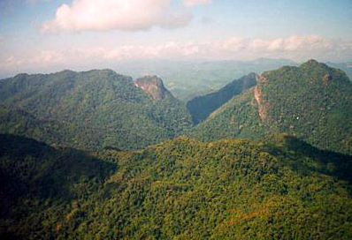
Phou Loei National Biodiversity Conservation Area, Laos. (Source: Photograph by IUCN/ Stuart Chape)
Introduction The Luang Prabang Montane Rain Forests are globally outstanding for bird richness (Luang Prabang montane rain forests) . This ecoregion has had limited biological exploration. Although more than 70 percent of this ecoregion's original montane vegetation has been converted to scrub or degraded forest, the remaining area presents some of the best opportunities for large mammal conservation in Indochina.
Location and General Description
 WWF
WWF
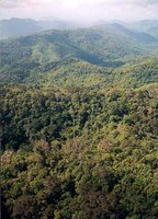
The Luang Prabang Montane Rain Forests ecoregion comprises areas largely above 800 meters (m) in north central Laos. This region grades to the north very gradually into the Northern Indochina subtropical forests Ecoregion and to the east into the Northern Annamites rain forests Ecoregion. Precise boundary lines between these ecoregions are somewhat arbitrary. The eastern gradient involves a gradual change in the amount of rainfall and length of the dry season.
Rather than a single community type, these forests include a variety of forest associations. Included within these forest habitats are montane hardwood forests of Fagaceae and Lauraceae, mixed conifer-hardwood forests, open montane forests, and open conifer forests. Montane habitats in northern Laos typically have 2,000-3,000 millimeters (mm) of annual rainfall but a long dry season.
 Phou Loei National Biodiversity Conservation Area, Laos. (Source: Photograph by IUCN/ Stuart Chape) Transitional communities of humid evergreen forest occur at about 800 m elevation, with Dipterocarpus turbinatus and Toxicodendron succedanea as the dominant canopy trees. Also characteristic are a variety of palms including Arenga saccharifera, Caryota, and Calamus spp. Montane habitats at 1,000-1,500 m may be dominated by a variety of forest communities representing both substrate differences and history of human disturbance. Evergreen forest originally represented by a variety of Fagaceae and other hardwoods is now dominated by Castanopsis hystrix, with Phyllanthus emblica as a co-dominant and Antidesma collettii, Helicia terminalis, and Wendlandia paniculata as important associates. The low stature of trees in this community and open understory with an abundance of broad-leaved monocots and grasses suggest severe past impacts from burning and clearance. Open conifer hardwood forests are also present, with open Quercus griffithii, Q. serrata, and the conifer Keteleeria evelyniana as the dominant tree species. Thin, granitic soils support an edaphic climax overwhelmingly dominated by Engelhardtia spicata with an understory cover of bracken fern, Pteridium aquilinum. Another edaphic climax occurs with open stands dominated by Pinus kesiya on skeletal soils of clay schist or sandstone.
Biodiversity Features
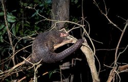 Pangolin species (Manis sp.), Laos. (Source: Photograph by Mark Kostich)
 This ecoregion lacks endemic mammals or birds, but that may be because of its inaccessibility and lack of biological surveys. However, the ecoregion harbors several threatened and endangered mammals of conservation significance, including the Francois's leaf monkey (Semnopithecus francoisi), silvered leaf monkey (S. cristatus), douc langur (Pygathrix nemaeus), tiger (Panthera tigris), Asian elephant (Elephas maximus), wild dog (Cuon alpinus), Himalayan black bear (Ursus thibetanus), sun bear (Ursus malayanus), clouded leopard (Pardofelis nebulosa), common leopard (Panthera pardus), thamin (Cervus eldii), and gaur (Bos gaurus). This ecoregion overlaps with two Level I Tiger Conservation Units (TCUs) and two Level II TCUs. There are more than 540 bird species whose ranges are shown to extend into this ecoregion, including the green peafowl (Pavo muticus).
Current Status
Table 1. WCMC (1997) Protected Areas That Overlap with the Ecoregion. Protected Area Area (km2) IUCN Category Nam Poui 1,900 VIII Phou Khao Khoay 1,890 VIII Phu Miang-Phu Thong 500 IV Phu Rua 140 II Unnamed 360 ? Phu Luang 850 IV Phu Hin Rong Kla 310 II Ton Krabak Yai 270 II Nam Nao 920 II Phu Khieo 1,590 IV Phu Pha Man 350 ? Chatrakhan 230 ? Total 9,310 Ecoregion numbers of protected areas that overlap with additional ecoregions are listed in brackets. Today many of the montane broadleaf forests in this ecoregion (Luang Prabang montane rain forests) have been converted to scrub or degraded habitat, primarily as a result of widespread shifting cultivation, and less than 30 percent of the original habitat now remains. In northeastern Thailand the Khorat Plateau is mostly deforested, although extensive forest still exists on the mountain ranges, especially in the steeper, more inaccessible slopes. The twelve protected areas cover 9,300 square kilometers (km2) (13 percent) of the ecoregion (Table 1). There are three protected areas—Nam Poui, Phou Khao Khoay and Phu Khieo—that are greater than 1,000 km2. Thailand's Nam Nao National Park and Phu Khieo Reserves are encompassed by Level I TCUs, and Laos's Nam Poui is included within a Level II TCU. ==Types and Severity of Threats== The primary threats to biological diversity in this ecoregion are from shifting cultivation, especially in the steeper slopes that people (especially in Vietnam and Thailand) are beginning to clear because of lack of land to support increasing populations, illegal hunting for a huge commercial trade that supplies China and loss of habitat caused by large hydro projects (especially in Laos and Vietnam), illegal logging, gahuru-wood and widlife (elephant and gaur) poaching, and road construction in Nam Poui. ==== ==Justification of Ecoregion Delineation== 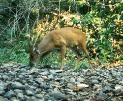 Barking deer (Muntiacus muntjak), Thailand. (Source: Photograph by Sean Austin) Barking deer (Muntiacus muntjak), Thailand. (Source: Photograph by Sean Austin) |
|---|