Lake Albert, Africa
| Topics: |
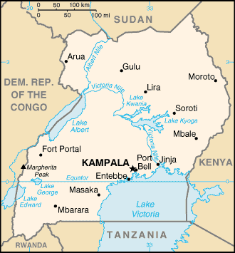
Lake Albert (also Lake Nyaza and formerly Lake Mubutu Sese Seko) is a major lake in central Africa on the border between Uganda and the Democratic Republic of the Congo (DRC) just north of the equator. It is part of the Nile River, receiving the outflow of the Lake Victoria via the Victoria Nile and Lake Edward via the Semliki River. The outflow of the lake is known as the Albert Nile.
Geography
Size: 100 miles (161 km) long; 20 miles (32 km) wide;
Area: 2,075 miles2 (5,374 km2)
Geographic coordinates: The lake extends north and slightly east from approximately 1o0' N 30o32' E to 2o21' N 31o28' E
Location: 135 miles northwest of Lake Victoria.
Surface altitude: 2,030 feet (619 m)
Maximum Depth: 168 feet (51 m)
A few miles from the northern tip of Lake Albert where the Albert Nile begins, the lake receives the flow of the Victoria Nile which drains Lake Victoria. Twenty miles east of Lake Albert, the Victoria Nile passes through Murchison Falls, where the river is reduced to just 20 feet (6 meters) and cascades 400 feet (120 meters) in three stages. Murchison Falls National Park sits on the northeast part of the lake.
In the south, the Semliki (Semuliki) River flows 143 miles (230 km) north across the equator from Lake Edward to Lake Albert. At the river's entrance into Lake Albert it forms a delta a mile or more wide on a alluvial plain that has built up from silt carried by the river.
Lake Albert in bisected by the border between Uganda and the Democratic Republic of the Congo (DRC). The border enters from the DRC side just south of where the Victoria Nile enters the lake and it runs southwest near the center of the lake to just east of the Semliki delta.
Lake Albert lies at the northern end of the Albertine rift, the western branch of the {C}Great Rift System, which runs from the {C}Middle East south through eastern {C}Africa to Mozambique. On its western (Democratic Republic of the Congo) side, the lake is flanked by the {C}Blue mountains which rise steeply from the side of the lake. Further south, the terrain becomes even steeper and the snow-capped mountains near the equator are named the Rwenzori Mountains. On the eastern (Uganda) side the terrain is a lot less steeper.
The area around {C}Lake Albert is included within the East Sudanian savanna ecoregion.
There are no major towns on the lake shore, but a number of small towns and villages exist. A bridge crosses the {C}Albert Nile at Pakwach at the northern outlet of the lake. Bulisa sits on the edge of the Victoria Nile's entrance to the lake. Mahagi-Port and Kasenyi sit of the eastern shore.
There are a number of protected areas on the edge of the lake including (from the northeast going clockwise) Murchison Falls National Park where the Victoria Nile enters the lake, Bugungu Wildlife Reserve, Bugoma Forest Reserve, and Semuliki Wildlife Reserve (formerly Toro Game Reserve) on the southern shore.
European discovery
The first European to discover the lake was the British explorer Samuel Baker in March, 1864 who named it after the recently deseased husband of Queen Victoria. It was circumnavigated by the Italian Romolo Gessi in 1876. The entire lake was originally part of the British "Uganda Protectorate", but the northwest shores were leased in 1894 to the Belgian "Congo Free State" which later became Zaire and then the Democratic Republic of the Congo. The modern border enters from the DRC side just south of where the Victoria Nile enters the lake and the runs southwest near the center of the lake to just east of the Semliki delta.
Further Reading
- Freshwater Ecoregions of Africa and Madagascar: A Conservation Assessment (World Wildlife Fund Ecoregion Assessments) by Michele L. Thieme, Robin Abell, Melanie L. J. S. Stiassny, Paul Skelton, Neil Burgess, Bernhard Lehner, Eric Dinerstein, David Olson, Guy Teugels, and Andre Kamdem-Toham, Island Press, 2005 ISBN: 1559633654.
- Africa by John Reader, National Geographic Society, 2001 ISBN: 0792276817.
- Merriam-Webster's Geographical Dictionary, Third Edition, 2007 ISBN: 0877795460.
- Uganda by Philip Briggs, Bradt Travel Guides; 5th edition, 2007 ISBN: 184162182X.
See Major rivers, lakes, mountains, and other terrestrial features of Uganda and Uganda country profile