La Costa xeric shrublands
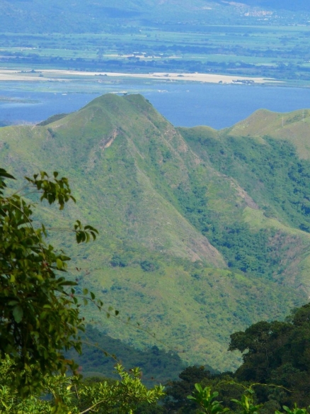
The Venezuelan Coastal Range of the northern Andes, and Lake Valencia, from biological Station in Rancho Grande, Henri Pittier National Park. The lower elevations of the mountains are mostly covered by the La Costa xeric shrublands ecoregion. (By Polarnik, Radosław Łabno (Own work) (http://www.gnu.org/copyleft/fdl.html) or CC-BY-SA-3.0-2.5-2.0-1.0 (http://creativecommons.org/licenses/by-sa/3.0), via Wikimedia Commons)
Introduction La Costa xeric shrubland is a distinctive habitat (La Costa xeric shrublands) that, like other surviving xeric areas, requires specific action to be conserved. Little natural habitat remains in this highly populated and disturbed ecoregion. A number of endemic avifauna is found here, including the yellow-shouldered amazon (Amazona barbadensis) and the Maracaibo tody-flycatcher (Todirotrum viridanum).
Location and General Description
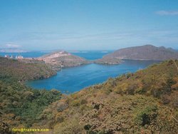 Mochima, Venezuela. (Photograph by Frank Angeli)
 The Costa xeric shrublands are part of the Coastal Cordillera geographical region, located in the northern part of Venezuela. The ecoregion extends from the state of Sucre to the state of Yaracuy along the coast of the Caribbean Sea. The western border of the ecoregion is determined by the Maracuy River, while the southern and eastern borders are determined by the change in vegetation from xeric shrublands to the Llanos grasslands, and mangroves, respectively. The Costa shrublands and savannas surround the montane forests of the Coastal Cordillera. Most of this region consists of a mosaic of agricultural lands mixed with deciduous thorn and thicket forest. The Caribbean coastal border is intermingled with mangrove, lagoons, hills containing islands of moist forest, and sandy [[coast]line].
The annual precipitation in the region ranges from 300 to 1000 millimeters (mm). The average temperature is 28 degrees Celsius (oC). The ecoregion lies between 0 masl (meters above sea level) in the coastal area to 1000 masl in the higher foothills.
The semi-arid area with dense scrubby xerophytic vegetation is located in the lowermost slopes, ranging from 2-200 masl. The vegetation includes 3-8 meters (m)-high thorn scrubs with the following dominant families: Cactaceae, Leguminosae, and Capparidaceae (Huber 1997). The thorn forest is dense, and includes Bourreria cumanensis, Caesalpinia conaria, Capparis coccolobifolia, C. brasiletto, Cereus hexagonus, Cercidium praecox, Chloroleucon mangense, Coccoloba ramosissima, Erythroxylum sp., Jacquinia sp., Mimosa sp., Pereskia guamacho, Piptadenia flava, Poponax flexuosa, P. tortuosa, Prosopis juliflora, and Xylosoma benthamii.
Savannas with herbaceous growth are found in the western part of the region. These savannas include the following species: Anoxopus canescens, Bowdichia virgilioides, Curatella americana, Leptocoryphium lanatum, Paspalum sp., and Trachypogon plumus. Savannas with shrubs are found throughout the ecoregion, and include tall grasses, palms, and shrubs. The plant species are Andropogon sp.,Axonoupus aureus, Borreria aristeguietana, Bowdichia virgilioides, Bryrsonima crassifolia, Bulbostylis sp., Casearia sylvestris, Cochlospermum vitifolium, Copaifera pubiflora, Curatella americana, Godmania aesculifolia, Leptocoryphium lanatum, Panicum sp., Polycarpaea corymbosa, Rhynchospora sp., Stilpnopappus pittieri, Trachypogon plumosus and Vochysia venezolana.
Biodiversity Features
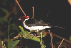 Red-capped cardinal (Paroaria gularis), Venezuela. (Photograph by S. E. Cornelius)
 Some of the endemic plant species in this xeric region are Borreria aristeguietana, Stilpnopappus pittieri.
Endemic mammalian terrestrial species characteristic of this ecoregion, and to others in dry forests in Colombia and Venezuela, are the opossum (Marmosa xerophila), and the vesper mouse (Calomys hummelincki). Marmosa is very well adapted to dry habitats, and is mainly found in deciduous forest, while the vesper mouse is mainly found in sandy grasslands.
There are various endemic birds restricted to the arid lowlands of the [[coast]al areas] of this ecoregion. The yellow-shouldered amazon (Amazona barbadensis) has a "vulnerable" status, and the Maracaibo tody-flycatcher (Todirotrum viridanum) has a "near threatened" status. The rest of the endemic birds in the area have a "least concern" status. They include the pygmy swift (Tachornis furcata), buffy hummingbird (Leucippus fallax), chesnut piculet (Picumnus cinnamomeus), white-whiskered spinetail (Synallaxis candei), black-backed antshrike (Sakesphorus melanonotus), slender-billd tyrannulet (Inezia tenuirostris), tocuyo sparrow (Arremonops tocuyensis), and vermilion cardinal (Cardinalis phoeniceus).
Current Status
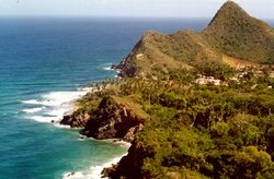 Choroni, Venezuela. (Photograph by Darcie E Shively)
 The coastal areas of Venezuela have been occupied since the arrival of the first European colonizers in the early 16th century. The entire northern part of the ecoregion is highly populated. The region has been heavily effected, especially at lower elevations. Most of the ecoregion has become a mosaic of vegetation formations due to anthropogenic impacts such as urban development, livestock grazing, and agriculture. The agricultural areas are extensively used for rice, maize, sugar-cane, cassava, sweet potato, and cotton crops. There are few natural savannas and thorn forests remaining.
Small areas of xeric shrublands are found in El Avila, Henri Pittier and San Esteban National Parks. All of these parks were created to protect mainly moist forests. Henri Pittier is one of the most affected protected areas, due the massive tourism in the area. The effects are especially felt in the beaches.
Types and Severity of Threats
High demographic density. This population growth has in turn triggered road building into previously inaccessible areas.
- Human activities such as cattle ranching, shifting and industrial agriculture, road construction, and fires.
- The growth of the tourism industry has caused the construction of more tourist and recreation resorts close to the larger cities.
- A major threat to the remaining natural vegetation are frequent fires lit during the dry season. These fires are also affecting in some place the adjacent montane evergreen forests.
- Although Venezuelan law protects the yellow-shouldered amazon, the domestic pet trade threatens it.
Justification of Ecoregion Delineation
This xeric shrubland spans much of northern [[coast]al] Venezuela and is home to a number of endemic species (Biodiversity). Initial classification follows Huber and Alarcon, however our broader scale classification encompasses many of their vegetation types, including "deciduous and semi-deciduous matorral", "matorral complex/shrub savanna", "piedmont shrub savannas", "shrub savannas", and all subsequent cultivated and agricultural lands included. The northern deliniation follows the coastline, and in this portion we have separated from this all montane forests [[region]s] (Cordillera La Costa Montane Forests). We then separated the Araya and Paria Peninsular area and its surrounding influences due to the distinct differences in species associations and restricted range species. Final linework however follows Smith.
Additional information on this ecoregion
- For a shorter summary of this entry, see the WWF WildWorld profile of this ecoregion.
- To see the species that live in this ecoregion, including images and threat levels, see the WWF Wildfinder description of this ecoregion.
- World Wildlife Fund Homepage
| Disclaimer: This article is taken wholly from, or contains information that was originally published by, the World Wildlife Fund. Topic editors and authors for the Encyclopedia of Earth may have edited its content or added new information. The use of information from the World Wildlife Fund should not be construed as support for or endorsement by that organization for any new information added by EoE personnel, or for any editing of the original content. |