Komodo National Park, Indonesia
Contents
- 1 Geographical Location
- 2 Date and History of Establishment
- 3 Area
- 4 Land Tenure
- 5 Altitude
- 6 Physical Features
- 7 Climate
- 8 Vegetation
- 9 Fauna
- 10 Cultural Heritage
- 11 Local Human Population
- 12 Visitors and Visitor Facilities
- 13 Scientific Research and Facilities
- 14 Conservation Value
- 15 Conservation Management
- 16 IUCN Management Category
- 17 Further Reading
Geographical Location
Komodo National Park (8°24'-8°50'S, 119°21'-119°49'E) is a World Heritage Site that lies in East Nusa Tenggara province in the Sape Straits between Flores and Sumbawa. Access to Komodo village is by boat from Labuan Bajo on the north-western tip of Flores or from Sape on the east coast of Sumbawa.
Date and History of Establishment
The islands of Komodo, Padar, Rinca and Gili Motong and the surrounding waters were declared a 75,000 hectare (ha) national park on 6 March 1980. This was extended to 219,322 ha in 1984 under Ministerial Decree 46/kpts/VI-Sek/1984 to include an expanded marine area and a section of mainland Flores. The island of Padar and part of Rinca were first protected in 1938 when they were established as nature reserves and extended in 1965 when Komodo Island was gazetted under Ministerial Decree No. 66. Komodo was internationally recognized as a Biosphere Reserve under UNESCO's Man and the Biosphere Programme in 1977 and inscribed on the World Heritage List in 1991.
Area
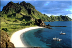
 Komodo National Park. (Source: Duke University)
 - Komodo National Park and Biosphere Reserve: 173,500 ha
- Mbeliling and Nggorang Protection Forest: 31,000 ha
- Way Wuul and Mburak Nature Reserve: 3,000 ha
- Komodo Island World Heritage Site: 219,322 ha
Land Tenure
State.
Altitude
Ranges from below sea level to 735 meters (m) at the summit of Gunung Satalibo.
Physical Features
The generally steep and rugged topography reflects the position of the national park within the active volcanic 'shatter belt' between Australia and the Sunda shelf. Komodo, the largest island, has a topography dominated by a range of rounded hills oriented along a north-south axis at an elevation of 500 to 600 m. Relief is steepest toward the north-east, notably the peak of Gunung Toda Klea which is precipitous and crowned by deep, rocky and dry gullies. The coastline is irregular and characterized by numerous bays, beaches and inlets separated by headlands, often with sheer cliffs falling vertically into the sea. To the east, Padar is a small, narrow island the topography of which rises steeply from the surrounding plains to between 200 m and 300 m. Further east, the second largest island in the park, Rinca, is separated from Flores by a narrow strait a few kilometers wide. The topography of the southern part of the island is dominated by the 667 m Doro Ora massif, while to the north the steep-sided peaks of Gunung Tumbah and Doro Raja rise to 187 m and 351 m, respectively. As with Komodo and Padar, the coastline is generally rugged and rocky although sandy beaches are found in sheltered bays. The mainland components of the park lie in the rugged coastal areas of western Flores, where surface fresh water is more abundant than on the islands of Komodo, Rinca and Padar. Geology reflects regional volcanism, with Pleistocene and Holocene deposits forming the principal geological units. Deposits are generally resistant volcanics, volcanic ash, conglomerates and raised coral formations.
According to Kvalvagnaes and Halim (1979), the seas around the islands are reported to be among the most productive in the world due to upwelling and a high degree of oxygenation resulting from strong tidal currents which flow through the Sape Straits. Fringing and patch coral reefs are extensive and best developed in the west and north facing areas, the most intact being on the north-east coast of Komodo and the south-west coast of Rinca and Padar.
Climate
The park lies within one of the driest regions of Indonesia with an annual rainfall of between 800 millimeters (mm) and 1,000 mm. Heaviest rainfall, higher humidity and lower temperatures are recorded during the monsoon between November and April. This pattern is reversed during the dry season from May to October, when mean daily temperatures are around 40 degrees Celsius (°C).
Vegetation
The predominant vegetation type is open grass-woodland savanna, mainly of anthropogenic origin, which covers some 70% of the park. The dominant savanna tree is lontar palm Borassus flabellifer, which occurs individually or in scattered stands. Grasses include Eulalia leschenaultiana, Setaria adhaerens, Chloris barbata, Heteropogon contortus and, in the higher areas, Themeda spp. including T. frondosa and T. triandra. Alang-alang Imperata cylindrica is conspicuous by its rarity. Tropical deciduous (monsoon) forest occurs along the bases of hills and on valley bottoms, characterized by tree species such as Sterculia foedita, Oroxylum indicum, Tamarindus indica, Zizyphus horsfeldi, Schleichera oleosa, Cassia javanica, Murraya paniculata, Diospyros javanica, Harrisonia brownii and Piliostigma malabaricum. The forest is notable, lacking the predominance of Australian derived tree flora found further to the east on Timor. A quasi cloud forest occurs above 500 m on pinnacles and ridges. Although covering only small areas on Komodo Island, it harbors a relict flora of many endemic species. Floristically, it is characterized by moss-covered rocks, rattan, bamboo groves and many tree species generally absent at lower elevations. These include Terminalia zollingeri, Podocarpus neriifolius, Uvaria rufa, Ficus drupacea, Callophyllum spectabile, Mischocarpus sundaicus, Colona kostermansiana and Glycosmis pentaphylla. Coastal vegetation includes mangrove forest, which occurs in sheltered bays on Komodo, Padar and Rinca. Dominant tree species include Rhizophora stylosa,R. mangle and Bruguiera sp., with Avicennia marina frequently occurring in large stands on the landward side. Other terrestrial vegetation types include pioneering beach vegetation, dominated by Ipomoea pescaprae. Plant species diversity is relatively low, with some 102 recorded. Extensive sea grass beds occur to the north end of Rinca Island.
Fauna
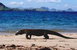
 The Komodo monitor Varanus komodoensis is the world's largest living lizard. (Source: Sacramento State University)
 The park is best known for the Komodo monitor Varanus komodoensis (R), the world's largest living lizard. The population, which is estimated at around 5,700 individuals, is distributed across the islands of Komodo (2,900), Rinca (900), Gili Motong (fewer than 100) and in certain coastal regions of western and northern Flores. The species is probably extinct on Padar, where it was last seen in 1975. Favored habitat is tropical deciduous forest, and, to a lesser extent, open savanna. Herpetofauna of the cloud forest includes Sphenomorphus schlegeli, S. striolatus and the frog Oreophryne jeffersoniana, while savannah areas harbour such species as Emoia similis, Viperia russelli and the frog Kaloula baleata. Tropical deciduous forest supports such reptiles as Sphenomorphus florensis, Trimeresurus albolabris, Dendrelaphis pictus and Lycodon aulicus. Common cobra Naja naja occurs in areas of disturbed agricultural land.
The mammalian fauna is characteristic of the Wallacean zoogeographic zone, with seven terrestrial species recorded including the endemic rat Rattus rintjanus. Other mammals include primates such as crab-eating macaque Macaca fascicularis. Introduced species, such as rusa deer Cervus timorensis and wild boar Sus scrofa, as well as feral domestic animals including horses and water buffalo, form important prey species for the Komodo monitor. Some 72 species of birds have been recorded, including yellow-crested cockatoo Cacatua sulphurea (V), noisy friar bird Philemon buceroides and common scrubhen Megapodius freycinet.
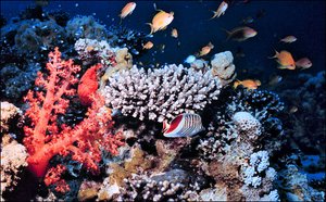
Upwelling of nutrient-rich water from deeper areas of the archipelago is responsible for the rich reef ecosystem of which only isolated patches remain due to anthropogenic disturbance. Dominant coral species on most reefs are Acropora spp., particularly table top coral Acropora symmetrica, as well as Millepora spp. and Porites spp. Fungia spp. are present on reef slopes. In areas of strong currents, the reef substrate consists of an avalanche of coral fragments, with only encrusting or low branching species, such as Seriatopora caliendrum and Stylophora pistillata, being able to withstand the rapid water flow. More protected reef slopes, for example in Slawi Bay, are dominated by species of the genus Heteropsammia and Heterocyathus. Reefs off the north-east of Komodo have a high species diversity including branching Acropora sp., Hydnophora sp., Seriatopora sp. and Caulastrea sp., as well as massive Porites sp., plate-like Echinophyllia sp., Merulina sp., Pachyseris sp. and numerous Fungiidae. The reefs off Gili Lawa Laut are variable, ranging from the sheltered southern bay with its large stands of Pachyseris sp., Echinopora sp., Mycedium sp., Echinophyllia sp. and Montipora sp., interspersed with thickets of Acropora spp., to the more exposed northern reefs which have a spur and groove structure dominated by Porites sp., Seriatopora sp. and Acropora sp.
Notable marine mammals include blue whale Balaenoptera musculus (E) and sperm whale Physeter catodon, which are occasionally observed, as well as 10 species of dolphin and dugong Dugong dugon (V). Marine reptiles include five species of turtle.
Cultural Heritage
It is thought that the islands have long been settled due to their strategic importance and the existence of sheltered anchorages and supplies of fresh water on Komodo and Rinca. The evidence of early settlement is further supported by the recent discovery of Neolithic graves, artefacts and megaliths on Komodo Island. The age of present settlements suggests that the inhabitants of Komodo village may have settled during the past 150 years, having been banished from Sumbawa by the Sultan of Bima. Local languages are unique, with that of Komodo having its origins on eastern Sumbawa, and that of Rinca originating from western Flores.
Local Human Population
 Coral Reef Komodo National Park. (Source: U.S. National Aeronautics and Space Administration Earth Observatory)
 According to a 1990 census, a growing population of approximately 1,500 people lives on the islands of Komodo and Rinca, an increase of 50% over the past decade. Of these, some 568 are located in the village of Kampung Rinca, 769 in the village of Kampung Komodo and 205 in Kerora. Several small seasonal fishing settlements lie on the east side of Rinca Island. The villagers subsist almost entirely by fishing, low rainfall having prevented extensive agricultural development. Some collection of marine resources, such as mollusks and algae for agar production, also takes place.
Visitors and Visitor Facilities
Annual visitor numbers have increased rapidly during the 1980s, rising from 100 in 1980 to 15,000 in 1990. Of these, some 90% are foreign nationals who visit during the dry season between June and September. A visitor center and accommodation facilities are located at Loho Liang on Komodo and an information center in Labuan Bajo on Flores. Limited losman (guest house) accommodation is available at Labuan Bajo on Flores and Sape on Sumbawa. The nearest hotel accommodation and airport facilities are located at Bima on Sumbawa.
Scientific Research and Facilities
Auffenberg (1981) has carried out ecological research on the Komodo monitor and cites numerous earlier studies including de Jong (1929), Hoogerwerf (1955), Darevsky (1963) and Kern (1968). In addition, Robinson and Supriadi (1981) have studied the Flores monitor population and Kvalvagnaes and Halim (1979) have conducted marine surveys. A field laboratory was completed in 1984.
Conservation Value
The park is of special importance for the conservation of most of the world population of the Komodo monitor. The location of the islands between two distinct zoogeographical zones, and the presence of a number of important cultural relicts, further underscores the site's scientific interest. The rich marine environment, particularly [[coral] reefs], provides the basis for the local fishing industry and enhances the park's potential for tourism.
Conservation Management
Management is primarily directed toward conserving the Komodo monitor, which has been protected by legislation since 1915. According to the 1977 management plan, the park is split into intensive use zones (intended to contain developments such as village enclaves and tourist and administrative facilities), wilderness zones (which provide for limited tourism, such as trails and camps) and sanctuary zones (which are strictly protected with access being restricted to authorized PHPA and research personnel). Management activities have focused on enforcement and provision of tourist facilities, including stations for viewing the Komodo monitor, which are baited twice a week at Loho Liang. Park headquarters are located at Labuan Bajo and there are six permanently staffed guard posts within the park. Sumardja (1981) makes a number of management recommendations including the development of buffer zones to provide resources for the village enclaves, and the expansion of regional and local development and conservation awareness programs. Robinson and Bari (1982) have recommended that emphasis on viewing the Komodo monitor from baiting stations be reduced and a more balanced program of nature walks be developed. Robinson et al. (1982) recommend a number of strategies to control deer poaching, including closing markets on Sumbawa and Flores by cooperating with the local government, as well as strengthening PHPA enforcement capability in Sape. It is further recommended that the intensive use zone be extended seawards by 1,000m to allow passage and anchorage of boats. There is an extensive marine buffer zone to the park, within which park authorities may regulate the type of fishing permitted and to some extent, even the presence of outside fishermen.
Management Constraints
The principal management problem is depletion of Komodo monitor prey stocks, such as rusa deer and wild boar, through predation by feral dogs and poaching. An associated problem is the burning of grassland which is most serious on the rarely patrolled western side of Komodo. Threats to the marine environment include dynamite fishing of [[coral] reefs] by itinerant fishermen from surrounding islands, and siltation of coastal waters due to erosion of fired grasslands. According to Robinson et al. (1982), the continued baiting of Komodo monitor for viewing by tourists may disrupt natural prey-predator relationships and also lead to loss of the fear of humans, possibly with fatal consequences.
Staff
A total of 90 in 1991 including 60 guards and 30 administrative staff.
Budget
Rp 160,000.000 (US$ 84,210) in 1990.
IUCN Management Category
- Komodo National Park, II, (National Park)
- Mbeliling and Nggorang Protection Forest, VI, (Resource Reserve)
- Way Wuul and Mburak Nature Reserve, Ia, (Strict Nature Reserve)
- Biosphere Reserve
- Natural World Heritage Site - Criteria iii, iv
Further Reading
- Auffenburg, W. (1980). The herpetofauna of Komodo, with notes on adjacent areas. Bulletin of the Florida State Museum Biological Sciences 25: 136-137.
- Auffenburg, W. (1981). The behavioural ecology of the Komodo Monitor. University of Florida, Gainsville, USA. 362 pp.
- Faculty of Forestry of UGM (1976). Feasibility study of Komodo Island Wildlife Reserve. (Unseen)
- FAO (1977). Proposed Komodo National Park management plan 1978-1982. FO/INS/73/013. Field Report No. 3. UNDP/FAO Nature Conservation and Wildlife Management Project. FAO, Bogor. 105 pp.
- Kvalvagnaes, K. and Halim, M.H. (1979). Report on a survey of marine areas of the proposed Komodo National Park. UNDP/FAO Nature Conservation and Wildlife Management Project FO/INS/78/061. Field Report No. 4. FAO, Bogor. 21 pp.
- MOF (1990). Nomination of Komodo National Park Indonesia for inclusion in the World Heritage list. Ministry of Forestry, Government of Indonesia, Jakarta. 25 pp.
- PHPA (n.d.). Komodo National Park. Directorate-General of Forest Protection and Nature Protection. Pamphlet.
- Robinson, A.H. and Supriadi, D. (1981). Conservation of the Komodo monitor Varanus komodoensis, West Flores feasibility study. UNDP/FAO National Parks Development Project FO/INS/78/061. Field Report No. 33. FAO, Bogor. 9 pp.
- Robinson, A.H. and Bari, A. (1982). Komodo National Park: progress and problems. Parks 7: 10-13.
- Robinson, A.H., Supriadi, D. and Anwar (1982). Komodo National Park: revision to the management plan. 1983/1984 - 1985/1986. UNDP/FAO National Parks Development Project. FAO, Bogor. 20 pp.
- Sumardja, E.A. (1981). First five national parks in Indonesia: Komodo National Park. Parks 6: 4.
- UNEP/IUCN (1988). Coral Reefs of the World. Vol 2: Indian Ocean, Red Sea and Gulf. UNEP Regional Seas Directories and Bibliographies. IUCN, Gland, Switzerland and Cambridge, UK/UNEP, Nairobi, Kenya. Pp. 122-124. ISBN: 2880329442
| Disclaimer: This article is taken wholly from, or contains information that was originally published by, the United Nations Environment Programme-World Conservation Monitoring Centre (UNEP-WCMC). Topic editors and authors for the Encyclopedia of Earth may have edited its content or added new information. The use of information from the United Nations Environment Programme-World Conservation Monitoring Centre (UNEP-WCMC) should not be construed as support for or endorsement by that organization for any new information added by EoE personnel, or for any editing of the original content. |