Kayah-Karen montane rain forests
Introduction The Kayah-Karen Montane Rain Forests ecoregion (Kayah-Karen montane rain forests) harbors globally outstanding levels of species richness. Among the ecoregions of Indochina, it ranks second for bird species richness and fourth for mammal species richness. The world's smallest mammal, Kitti's hog-nosed bat (Craseonycteris thonglongyai), equal in mass to a large bumblebee, resides in the limestone caves of this ecoregion. Because the ecoregion remains unexplored scientifically, especially the parts that lie in Myanmar, it probably will yield more biological surprises.
Location and General Description
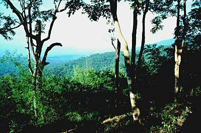
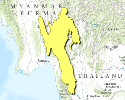
This ecoregion includes the northern part of the Tenasserim Mountain Range, which forms the border between Thailand and Myanmar. Much of the region consists of hills of Paleozoic limestone that have been dissected by chemical weathering. The overhanging cliffs, sinkholes, and caverns characteristic of tropical karst landscapes are all present in this ecoregion. Large patches of limestone forest are associated with the tropical karst. The flora and fauna here is distinct and includes several endemic species. Because complex habitats are little explored, it is likely that they contain undescribed endemic species.
Terrain throughout much of this ecoregion is rugged and intricately folded. Hillsides tend to be steep, and ridges exceed 2,000 meters (m) elevation. Valley bottoms are narrow but fertile and tend to lie at about 300 m elevation. The western slopes drain into the Salween River, which flows through Myanmar and into the Gulf of Martaban in the Indian Ocean. The eastern slopes drain into the Chao Phraya River, which drains into the gulf of Thailand.
Although the limestone that makes up much of this mountainous ecoregion was deposited in a shallow marine environment more than 300 million years ago, the mountains themselves are much younger and owe their existence to the collision between the Indian and Eurasian continental plates that produced the Himalaya about 50 million years ago.
The entire region has a monsoonal climate with warm, moist summers and mild winters that tend to be dry. Overall annual rainfall averages 1,500 to 2,000 millimeters (mm). Although this ecoregion lies within the Tropic of Cancer, winter temperatures can be cool, especially at the higher elevations, where frost has been recorded from the northern part of the ecoregion. West-facing slopes (on the Myanmar side) face the Bay of Bengal and receive more precipitation. East-facing slopes (on the Thailand side) lie within a partial rain shadow and tend to be drier. This climatic difference is clearly reflected in the vegetation. Forests to the east are dominated, especially at the lower elevations, by trees that have a drought-deciduous phenology, whereas the west-facing slopes are a mixture of deciduous and evergreen species.
Edaphic factors also affect the vegetation: forests on granite, with a higher water-holding capacity, tend to support a higher proportion of evergreen broadleaf species, whereas forests on limestone are mostly drought-deciduous. Plants on bare limestone crags have a distinctive physiognomy, with fleshy stems and small, sometimes ephemeral leaves.
At low elevation (below about 1,000 m) on the east side of the Tenasserim Hills, potential vegetation consists of drought deciduous forest or savanna woodland. Although fire is common today, there is little consensus as to the historical frequency of fire or its importance in this ecosystem. An important unresolved question is whether fire (mostly anthropogenic) or pre-monsoon drought stress (non-anthropogenic) is primarily responsible for limiting species diversity in these places. Forests of teak Tectona grandis represent the climax vegetation at low elevation in the absence of fire, but today the teak forests are nearly extirpated in Thailand and declining rapidly in Myanmar. Places at low elevation where fires are more common support a savanna woodland. Doi Suthep National Park near Chiangmai, Thailand provides an example. Here the woodlands are dominated by dipterocarps such as Dipterocarpus tuberculatus and D. obtusifolia and oaks such as Quercus kerrii. Trees grow up through a grassy ground cover that dries in the winter and often burns in spring. Lack of closed-canopy forests encourages the growth of annual grasses, which in turn promote fire. Rare, distinctive plants include the drought-adapted epiphyte Discidia major, which grows in mutualistic symbiosis with ants that live inside specially modified leaves, and Phoenix acaulis, a small, fire-adapted palm.
Higher elevations support much richer broad-leaved forest communities with a mixture of evergreen and deciduous species. At 800-1,200 m, a well-developed shrub understory grows beneath a tall, closed forest canopy that includes some very large, buttressed trees that share an affinity with tropical Asia together with temperate tree taxa in the families Magnoliaceae and Lauraceae. Shady conditions at ground level favor woody climbers that include strangler figs (Ficus spp.) and the cablelike Gnetum, an unusual climbing gymnosperm. Sapria himalaica is a rare component of the forest understory here. This root parasite, with its large, red flowers and underground stems, is related to the giant Rafflesia of Borneo and Sumatra.
Ridgetops include a plethora of Himalayan plant taxa including members of the oak family (Castanopsis, Quercus, and Lithocarpus), Schima wallichii, and members of the birch and alder families. Rhododendron occurs at the highest elevations throughout this ecoregion.
Species diversity in Doi Suthep National Park, near Chiangmai in northern Thailand, rivals that of the most diverse seasonal forests. On Thailand's sandy northern hills, a fire-maintained climax of open stands of the three-needle pine Pinus kesiya and the two-needle pine P. merkusii occur at 550-1,800 m elevation.
Biodiversity Features
The ecoregion is the fourth richest in the Indo-Pacific region for mammals, with 168 known species. These include one ecoregional endemic species, the tiny Kitti's hog-nosed bat, Craseonycteris thonglongyai (Table 1). This bat, weighing a mere 2 grams (g) and with an 8-centimeters (cm) wingspan, is confined to the limestone caves in western Thailand. This bat is now threatened because collectors catch large numbers to make taxidermy mounts that are sold to tourists. The forests around the caves have also been cleared and probably will lead to a change in the cave microclimate.
|
Table 1. Endemic and Near-Endemic Mammal Species. Family Species Craseonycteridae Craseonycteris thonglongyai* An asterisk signifies that the species' range is limited to this ecoregion. Some of the other mammals of conservation importance include several threatened species such as the tiger (Panthera tigris), Asian elephant (Elephas maximus), gaur (Bos gaurus), banteng (Bos javanicus), wild water buffalo (Bubalus arnee), southern serow (Naemorhedus sumatraensis), clouded leopard (Pardofelis nebulosa), Malayan tapir (Tapirus indicus), wild dog (Cuon alpinus), Asiatic black bear (Ursus thibetanus), Assamese macaque (Macaca assamensis), stump-tailed macaque (Macaca arctoides), smooth-coated otter (Lutrogale perspicillata), great Indian civet (Viverra zibetha), and particoloured flying squirrel (Hylopetes alboniger). Sumatran rhinoceros is believed to have inhabited remote regions (Kayah-Karen montane rain forests) of the Tenasserim Hills in recent years, but this critically endangered species is now thought to have been extirpated from this ecoregion. The relatively intact, contiguous habitat has potential to conserve large landscapes that will provide adequate habitat to maintain a viable population of Asia's largest carnivore, the tiger, as well as other species of critical conservation significance. Therefore, the ecoregion lies within a high-priority (Level I) Tiger Conservation Units (TCU). Several of Thailand's largest and most intact wildlife reserves lie within this ecoregion, including Huai Kha Khaeng Wildlife Sanctuary (2,575 square kilometers [km2]) and several other protected areas with which it forms a contiguous network. Huai Kha Khaeng is prized for the high diversity (Species diversity) of cat species it supports and its relatively intact vertebrate communities and intact lowland dipterocarp forests. Moister habitats on the Myanmar side of the Tenasserim Range also include significant amounts of intact habitat, probably still in better condition overall than the forest on the eastern (Thai) side of the range. However, it is difficult to assess ecological conditions in the forests of eastern Myanmar at this time. {| border="1" cellpadding="3" align="right" ! colspan="3" | Table 2. Endemic and Near-Endemic Bird Species. Family Common Name Species Timaliidae Deignan's babbler Stachyris rodolphei* Timaliidae Burmese yuhina Yuhina humilis* An asterisk signifies that the species' range is limited to this ecoregion. The ecoregion's 568 bird species make it the second highest in terms of species richness (Kayah-Karen montane rain forests) . These include two ecoregional endemic species (Table 2). But there are several other birds that are indicators of habitat integrity and are thus of conservation importance, such as Lady Amherst's pheasant (Chrysolophus amherstiae), Hume's pheasant (Syrmaticus humiae), silver pheasant (Lophura nycthemera), grey peacock-pheasant (Polyplectron bicalcaratum), green peafowl (Pavo muticus), Kalij pheasant (Lophura leucomelanos), brown hornbill (Anorrhinus tickelli), plain-pouched hornbill (Aceros subruficollis), rufous hornbill (Buceros hydrocorax), great hornbill (Buceros bicornis), wreathed hornbill (Aceros undulatus), and white-winged duck (Cairina scutulata). The great slaty woodpecker (Muellerpicus pulverulentus), the largest Old World woodpecker, is an uncommon resident of lowland forests and low hills in this ecoregion. It is particularly sensitive to degradation of late-successional forests because it needs large, dead trees. Some of these are threatened species, and the white-winged duck and plain-pouched hornbill in particular are globally threatened. ==Current Status== {| width="320" border="1" cellpadding="3" align="right" ! colspan="3" | Table 3. WCMC (1997) Protected Areas That Overlap with the Ecoregion. Protected Area Area (km2) IUCN Category Mae Yuam Fang Khwa 1,510 IV Doi Chiang Dao 510 IV Namtok Mae Surin 400 II Doi Suthep-Pui 190 II Doi Inthanon 480 II Salawin 930 IV Doi Khuntan 250 II Doi Pha Muang 220 IV Omgoy 1,060 IV Kahilu 110 UA Mae Tuen 1,400 IV Ton Krabak Yai 250 II Lansang 110 II Klong Wang Chao 700 II Umphang 2,440 IV Khlong Lan 430 II Mulayit 70 UA Mae Wong 930 II Thung Yai Naresuan 3,930 IV Huai Kha Khaeng 2,480 IV Si Nakarin 1,830 II Chaloem Rattanakosin 60 II Salak-Phra 830 UA Erawan 530 II Mae Ping 100 II Khao Laem 380 II Unnamed 1,080 ? Doi Pha Muang 270 IV Total 23,480 About a third of this ecoregion (Kayah-Karen montane rain forests) has been cleared or degraded; however, the twenty-eight protected areas cover almost 23,500 km2 (20 percent) of its area (Table 3). The average size of the protected areas is 725 km2. But the system includes several protected area complexes, such as Thailand's Huay Kha Khaeng-Thung Yai Naresuan Reserve complex (with eleven protected areas) and the Omgoy-Mae Ping-Mae Tuen reserve complex, which cover much larger areas. ==Types and Severity of Threats== Shifting cultivation is the main cause of deforestation throughout the region. But in areas such as northern Thailand, where previously nomadic tribal peoples have been settled, pressure exists to convert forest into more intensive agricultural land devoted to cash crops such as cabbage, coffee, and lychee. Opium replacement efforts (in Thailand but not Myanmar) have compelled local people to grow alternative crops that need more cultivated land area and higher pesticide inputs. The land needs of an increasing population have forced itinerant farmers to reduce the cycle of cultivation-fallow periods and have pushed them deeper into the forest and into more marginal areas. Remote hill areas occupied by ethnic minorities have suffered considerable degradation. However, the places occupied by the majority culture are more likely to have been completely converted to rice cultivation. Hunting has decimated most of the large mammal populations, such as elephant, banteng, gaur, and tiger. Gibbons and hornbills, species important for dispersing seeds of many forest tree species, have also been severely reduced in many areas. ==Justification of Ecoregion Delineation== The extensive Indochina biounit (10) identified by MacKinnon in his conservation analysis of the Indo-Malayan realm comprises three subunits that represent the tropical lowland plains, subtropical hills, and temperate montane areas. The largest of these subunits, Central Indochina (10a), is a mix of tropical moist forests and tropical dry forests. We delineated eight [[ecoregion]s] that overlap with this biounit by assigning the different vegetation types of ecoregional extent into each. This ecoregion represents the semi-evergreen forests of the Kayah-Karen mountains in the broad transition zone between the subtropical broadleaf evergreen forests in the north and the southern dry deciduous forests. ==Additional information on this ecoregion== * For a shorter summary of this entry, see the WWF WildWorld profile of this ecoregion. * To see the species that live in this ecoregion, including images and threat levels, see the WWF Wildfinder description of this ecoregion. * World Wildlife Fund Homepage |
|---|


