Kalahari Acacia-Baikiaea woodlands
Contents
Kalahari Acacia-baikiaea Woodlands
Semi-arid Kalahari Acacia-baikiaea Woodlands stretches across the center of southern Africa, from northern Namibia through Botswana and slightly into the Tuli Block of South Africa. Surface water is scarce, and droughts occur approximately once every seven years. Therefore, the human population is relatively low, particularly on the sandveld that covers most of the ecoregion. This Kalahari woodland supports a rich and diverse fauna, including a variety of ungulates and a number of threatened large mammalian taxa such as White Rhinoceros (Ceratotherium simum), Black Rhinoceros (Diceros bicornis), Painted Hunting Dog (Lycaon pictus), and African Elephant (Loxodonta africana). However, human populations are increasing, and the burgeoning cattle industry has far-reaching adverse effects on the natural environment and wildlife. The migrations of large herbivores which previously occurred in the ecoregion are now hindered by veterinary control fences, resulting in mass wildlife die-offs, especially in times of drought.
Location and general description

The Kalahari Acacia-Baikiaea Woodland ecoregion is found in the center of southern Africa. The largest area of the ecoregion occupies a broad band from northern Namibia running diagonally across Botswana, ending in the southeast near the border with South Africa. Within Botswana, a smaller area extends northwards between the Okavango Alluvial Fan along the Kwando River, and southward to the Makgadigkadi Pans towards the border of the Chobe Nature Reserve and then leads east, just crossing the border into Zimbabwe. To the south, a small fraction of the ecoregion extends into the northern province of South Africa, into an area called the Tuli Block.
The climate of the ecoregion is semi-arid, with droughts occurring on a seven-year cycle. The highly variable rainfall occurs mostly in the summer months, from October through March. Most rainfall is in the form of thunderstorms, depositing between 15 mm to 90 millimetres (mm) of rain within a few hours. These seasonal storms have a marked regeneration effect on the vegetation. During the austral winter months – from May through August – there is little or no rain and no surface water to sustain vegetation. The annual rainfall ranges from about 300 mm in the southwest to 600 mm in the north, with significant variation from year to year. Temperatures are typical of a continental climate, with high diurnal and seasonal ranges. In June and July, temperatures can drop below freezing, but in the summer months temperatures may exceed 40°Celsius (C). The mean maximum temperature is between 27° and 30°C and the mean minimum temperature is between 9° and 12°C.
The ecoregion lies in the center of the Great African Plateau. Most of the ecoregion is covered by sediments of the Kalahari group (mostly Kalahari Sand) and is termed the Sandveld or the Kalahari. This area lies at an elevation of about 1000 metres (m), with very little topographic variation. A few granitic hills are scattered in the central area of the ecoregion (the Tsau and Khwebe hills) and in the northwest (the Tsodilo, Aha, and Gcwihaba hills). These hills rise to just above 1300 m and are isolated topographical features in the otherwise flat landscape of the Kalahari. The soils of this region are very deep (up to 150 metres) and are mostly arenosols of poor water-retention capacity. To the southeast of the ecoregion, the sandveld grades into an undulating plain, called the hardveld, that varies from 1000 m to 1150 m. The rock formations underlying the hardveld are varied and have led to a profusion of complex rock formations and vegetation types in the area. Around the towns of Mahalapye and Phalapye, there are hill massifs, such as the Mokgware, Tswapong, and Shoshong Hills, which are developed from ancient Precambrian rocks. The soils of the hardveld are highly leached, ferruginous and tropical, and are more arable than those of the Kalahari.
The vegetation of the sandveld is largely determined by climate. To the south of the ecoregion, where the climate becomes more arid, the sandveld vegetation grades into the sparse, shrubby, Acacia-dominated Kalahari Xeric savanna ecoregion. To the north, the climate becomes moister and the vegetation grades into a mesic savanna or woodland dominated by Baikiaea plurijuga, the Zambezian Baikiaea woodland ecoregion. To the southeast, the vegetation of the hardveld grades into a complex mix of vegetation types outlined in the Southern African Bushveld ecoregion description.
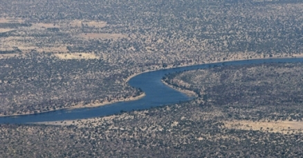
Surface water resources are scarce within the ecoregion. In the hardveld to the southeast of the ecoregion, drainage consists of a number of ephemeral sand rivers that drain into the Limpopo River, itself a seasonal river within this ecoregion. The Mhalatswe and Lotsane are the largest of these rivers within the ecoregion. Water flows in these rivers for only a few weeks a year, but despite their erratic flow these rivers are an important source of water locally, due to the reliable groundwater reserves within their beds. The watershed of these eastern rivers divides Botswana into its two main geological regions: the sandveld and the hardveld. Most of this ecoregion is located on the sandveld; only in the southeast does the ecoregion lie on hardveld. Fossil valleys now represent rivers that may have flowed west of this watershed in ancient times, to the Great Kalahari Lake. Deception, Quoxo, and Groot Laagte are three major fossil valleys found within the sandveld of the ecoregion. Surface drainage over the sandveld areas of the ecoregion is mainly restricted to pans and dry valleys, and surface water is only present after rain. There is one ephemeral river, the Boteti River, which flows out of the Okavango Alluvial Fan and into the Makgadigkadi Pans, crossing through this ecoregion between the delta and the pans. Because of massive evaporation and the sand substrate of the delta, the outflow of the Okavango Alluvial Fan is only about five percent of the inflow, leaving very little water to discharge irregularly down the Boteti River. No appreciable amount of water has reached the Makgadigkadi Pans from the Boteti River in more than fifteen years. In the sandveld, most of the human and animal populations are dependent on groundwater supplies as their water source.
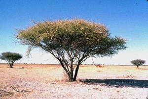
Deciduous tree and bush savanna covers most of the ecoregion, in the sandveld area. Taller trees are mainly confined to low sand ridges and are dominated by Terminalia sericea, Burkea africana, Peltophorum africanum, Croton gratissimus, Rhus tenuinervis, Acacia giraffe, A. fleckii, A. luederitzii, Cobretum zeyheri, C. apiculatum, and Ziziphus mucronata. A shrub savanna occurs on the gently rolling plains between the sand ridges and is mainly composed of Dichrostachys cinerea, Grewia flava, G. flavescens, Acacia mellifera, Bauhinia macrantha, Ximenia caffra, and Commiphora pyracanthoides. The grass cover includes Stipagrostis uniplumis, Aristida meridionalis, A. congesta, Eragrostis pallens, E. superba, Heteropogon contortus, Cymbopogon excavatus, and Digitaria eriantha.
To the north, in the area west of the Okavango Alluvial Fan and in the area occupying northeast Namibia, the tree savanna becomes dominated by Baikiaea plurijuga, with varying proportions of Colophospermum mopane and Burkea africana. With fire protection, a dense shrub layer develops and Baphia massaiensis, Bauhinia petersiana, and Paropsia brazzeana are all common. The grass layer is sparse when the shrubby understory is well developed, but when it is more open, species such as Aristida meridionalis, A. congesta, Eragrostis pallens, and E. lehmanniana are found. Baikiaea plurijuga (Caesalpinaceae) is fire sensitive, and when fire damage is severe, it can disappear completely. Baikiaea plurijuga may have dominated a larger area of the ecoregion prior to the anthropogenic influences of fire, cultivation and woodcutting.
In the southeast of the ecoregion, on the hardveld, the vegetation patterns are more complex as a result of changing soil types, linked with complex changes in the underlying geology. In the area south of the Makgadigkadi Pans, Colophospermum mopane begins to dominate the tree savanna with large trees of Acacia nigrescens, Terminalia prunioides, and Combretum imberbe present in varying proportions. Accompanying shrubs include Dichrostachys cinerea, Mayenus cymosa, and Grewia flava. The dominant grasses are Cenchrus ciliaris, Digitaria milanjiana, Eragrostis spp., and Dichanthium papillosum. This mopane tree savanna extends south across the South African border into the area known as the Tuli Block. Around the town of Phalapye, the vegetation changes and again resembles the Terminalia sericea dominated tree savanna that covers the sandveld area of the ecoregion. To the west of this, in an area surrounding the town of Mahalapye, the vegetation becomes a more open tree savanna of Acacia nigrescens, sometimes found along side Sclerocarya caffra, Peltophorum africanum, Acacia giraffe, and Combretum imberbe. Smaller trees include Combretum apiculatum, C. molle, Terminalia sericea, Acacia tortillis, Dichrostachys cinerea, Grewia flava, G. retinervis, and G. tenax. The grass cover is mixed but includes Panicum maximum, Digitaria eriantha, and Eragrostis lehmanniana. South of the town of Mahalapye, Combretum imberbe and Peltophorum africanum dominate the tree savanna with a dense shrub cover of Combretum hereroense, Dichrostachys cinerea, Acacia tortilis, and Grewia flava present under the canopy.
Biodiversity features
.jpg)
Within White’s classification, the ecoregion falls into two phytochoria: the Zambezian region and the Kalahari-Highveld Transition Zone. The Kalahari Acacia-Baikiaea Woodland is at the southern end of the Zambezian phytogeographic region, which is rich in total plant taxa (approximately 6000 species) in comparison with other proximate ecoregions. On a per unit area basis, however, the species richness is low, as species are evenly distributed throughout the estimated 2.6 million square kilometres. The southern end of the Zambezian region is relatively biologically of lesser biodiversity, and the ecoregion therefore has a relatively low level of species richness with few endemic species. The Kalahari-Highveld Transition Zone is a region of transition from the tropical Zambezian to the arid Karoo-Namib regions. Although the largest pytogeographical region in southern Africa, it is relatively poor in species and has few endemics, exemplifying its transitional nature.
The levels of species richness and endemism for the fauna of the ecoregion reflect the patterns of the flora. There is a relatively high level of total species richness but a low per unit area richness and low local endemism.
Mammals
The ecoregion does support many of the charismatic large mammals associated with African savannas. While these species are not endemic, several are listed as threatened by the IUCN, including the critically endangered Black rhinoceros (Diceros bicornis), and two species listed as vulnerable, the Cheetah (Acinonyx jubatus) and the Brown hyena (Hyaena brunnea). Predators range from smaller species such as African civet (Civettictis civetta) and Serval (Felis serval) to Lion (Panthera leo), Leopard (Panthera pardus), Painted hunting dog (Lycaon pictus) and both Brown and Spotted hyena (Crocuta crocuta).
Many of the large herbivores found in the ecoregion undertake seasonal migrations, especially during droughts. Blue wildebeest (Connochaetes taurinus), Eland (Taurotragus oryx), Zebra (Equus burchelli), Cape Buffalo (Syncerus caffer), and Hartebeest (Alcelaphus buselaphus) all migrate within this ecoregion. Increasingly, veterinary foot and mouth control fences are restricting migration routes and endangering wildlife populations.
.jpg)
Birdlife
The ecoregion has a rich and colourful avian fauna, with 468 species recorded to date. Bradfield’s hornbill (Tockus bradfieldi) is one of only two species considered near-endemic to this ecoregion, found in the north of the ecoregion, the Okavango Alluvial Fan, and northwest Zimbabwe, where it is utilises Baikiaea and mixed Mopane woodlands. The Blackfaced babbler (Turdoides melanops) is the other near-endemic, found in the area west of the Okavango Alluvial Fan and extending into Namibia. It inhabits the understory of broad-leafed and mixed Acacia woodlands. The lappet-faced vulture (Torgos tracheliotus), is considered vulnerable by BirdLife International (2000) and is found throughout the ecoregion.
Amphibians and reptiles
There are 31 amphibian and 92 reptile species found within the ecoregion. None of the amphibian species is endemic or near-endemic, but six of the reptile species are near-endemic, and one, the Tsodilo thick-toed gecko (Pachydactylus tsodiloensis), is a strict endemic. It is found only on the Tsodilo Hills in the northwest of the ecoregion. Near-endemic reptilians include Kalahari purple-glossed snake (Amblyodipsas ventrimaculata), Kalahari ground gecko (Colopus wahlbergii), and Leonard’s spade-snouted worm lizard (Monopeltis leonhardi).
Current ecoregion status
Much of the ecoregion’s natural vegetation remains intact, but there are only two protected areas: the Central Kalahari Game Reserve in Botswana and the Khaudom Game Reserve in Namibia. The Central Kalahari Game Reserve, which protects 51,800 km2 of sandveld, extends into the center of the ecoregion. The reserve contains large herds of blue wildebeest, red hartebeest, eland, gemsbok (Oryx gazella) and springbok (Antidorcas marsupialis) as well as lion, cheetah, leopard, African wild dog and both brown and spotted hyena. The reserve is still inhabited by groups of indigenous bushmen, and for this reason only limited public access is allowed with a permit. Khaudom Game Reserve is one of the most recently proclaimed reserves in Namibia. It covers 3840 km2 of flat sandveld in the northeast of the ecoregion. It boasts abundant wildlife, particularly during the rainy season when animals are attracted to the area by the presence of water and grazing. There is a wide variety of wildlife to be found here including herds of elephant (Loxodonta africana), buffalo, giraffe (Giraffa camelopardalis), blue wildebeest, red hartebeest, tsessebe (Damaliscus lunatus), roan antelope (Hippotragus equinus), gemsbok, kudu (Tragelaphus strepsiceros) and eland, as well as all the large predators.
While the Central Kalahari and Khaudom Game Reserves protect large areas of the sandveld, there is little protection of the hardveld in the southeast of the ecoregion. The hardveld is the most densely populated area of the ecoregion, with most of Botswana’s population living in towns in this area. The sandveld, on the other hand, (which makes up most of the ecoregion) is very sparsely populated, with fewer than five persons per km2. Prior to the year 1966, a considerable amount of the land in the hardveld area was granted to European farmers, and much is still owned by these farmers. There is only one reserve in this area, the Stevensford Private Game Reserve, which is a small reserve located on the north bank of the Limpopo, southeast of the town of Phalapye.
In the mid-1970s the Botswana government proposed a network of Wildlife Management Areas (WMAs). These WMAs are chiefly in areas of land adjacent to reserves and are designed as areas where the wildlife industry can be developed on a sustainable basis. Though designated, none of the WMAs has yet been gazetted, partly because of opposition from the cattle lobby at the national level and from native villagers who regard hunting as their right, and resent having to pay for a license. The WMAs increase the area of sandveld under protection, but additional management areas are not proposed for the hardveld area.
Types and severity of threats
The cattle industry is the biggest threat to conservation within the ecoregion. Increased cattle herds cause overgrazing, which changes the composition of natural vegetation, particularly by the replacement of sweet grasses such as Chloris gayana, Cynodon dactylon, Eragrostis pilosa, and Urochloa trichopu by less palatable species such as Aristida congesta. The influx of people and livestock in previously uninhabited areas is threatening wildlife populations. The decline of wildlife populations is caused by competing with livestock for grazing, hunting of wild animals, and the removal of species considered problem animals, such as predators. The poisoning of predators has disastrous effects for other species, and has caused a large decline in lappet-faced vultures, for example, The expansion of the cattle industry into previously inaccessible areas has been facilitated by the virtual elimination of tsetse fly and by logistical support from the Botswana government. The government has provided land, finance, boreholes, veterinary services, genetic improvement programs, supplementary feeding subsidies, and transport to market and abattoir facilities. The government has also organized and subsidized the marketing of beef. Government responses to resulting problems, including overstocking, overgrazing, poor range management, and the illegal occupation of protected land, especially WMAs (for example in the Nata area), have not been adequate or effective.
Veterinary cordon fences are erected to control the spread of foot and mouth disease to cattle and pose a major threat to wildlife populations. Networks of these fences criss-cross much of Botswana. Within the ecoregion, the Kuke Veterinary fence cuts across the central Kalahari, across the middle of the ecoregion. The Makalamakedi veterinary fence runs southeast of the Okavango Alluvial Fan, meeting the Kuke fence. Other fences occur throughout the area between the Okavango Alluvial Fan and Makgadigadi Pans. These fences have been strongly criticized by conservationists, because they cause the massive die-off of migratory herbivores. Many wildlife species in this semi-arid region have ranges that vary according to seasons. During drought, large herbivores such as wildebeest, eland, and hartebeest move in search of surface water. Wildebeest spend the wetter months along the boundary between the towns of Ghanzi and Kgalagadi, and move northeast towards the Central Kalahari Game Reserve during the dry season. They encounter the Kuke and Makalamakedi veterinary fences, and are channeled into the Boteti and Lake Xau areas. These areas are highly overgrazed by cattle, particularly near water sources. As a result, the wildebeest often die of starvation if they remain here near water, but will die of thirst if they move to better grazing. In the drought of the 1980s, ninety percent of the wildebeest population died.
Hartebeests show a similar migratory pattern during times of drought, with 83 percent of the population lost in the 1980s drought. Cape Buffalo and zebra are mainly concentrated around the permanent water of the Okavango Alluvial Fan and Chobe River areas in the dry season. During the wet season, these herds have historically moved south. Fences, running from east to west above the Makgadigadi Pans area, now prevent this migration. The herds are now channeled east above the fence and cross the Botswana border into Zimbabwe. There has been a massive decline in buffalo and zebra populations since 1987. The veterinary cordon fences are erected without environmental impact assessments, but with full knowledge that they have a massive impact on populations of wild ungulates during times of drought.
Hunting is considered the mainstay of tourism in the ecoregion and gives the best return on investment. Commercial hunting was introduced in the early 1960s when hunting was outlawed in Kenya, and hunting companies looked for new hunting grounds. Large concession areas were allocated to hunting companies at the time. In 1978, the unified hunting regulations were put into place, and licenses were available at low prices for traditional hunting. These licenses were illicitly bought by non-rural citizens, who had no need to hunt, and sold to illegal hunting operations at higher prices. Such abuses of the system have disadvantaged the rural people who are dependent on hunting for their subsistence, and has resulted in negative attitudes towards the Department of Wildlife and National Parks (DWNP). However, the licenses are distributed on a quota system and hence are not a major threat to the wildlife of the area. Illegal hunting and poaching are serious threats to wildlife in the ecoregion, particularly to the white and black rhinoceros (Stuart et al. 1990). Poaching counter-measures need to be properly implemented and additional resources allocated to this activity.
After independence, the mineral sector burgeoned to become the driving force of the country’s economic growth. The principle mineral developments include the diamond mines at Orapa and Lethlakane in the center of the ecoregion. While these mines pose little threat to the conservation of the ecoregion as a whole, they have developed an industry based on a non-renewable resource. Fortunately, the diamond reserves are large, and the mines are expected to last well into the twenty-first century. This will permit time to develop economic strategies that are based on renewable resources, such as tourism.
Justification of ecoregion delineation
This ecoregion, stretching from Northeastern Namibia to South African Highveld, follows White’s ‘Colophopsermum mopane woodland and scrub woodland,’ and small portions of ‘South Zambezian undifferentiated woodland.’ It spans the southern extent of the Zambezian Regional Center of Endemism and the northern portion of the Kalahari-Highveld Regional Transition Zone, which is a transition from the tropical Zambezian to the arid Karoo-Namib regions. The ecoregion’s low levels of endemism highlight its transitional nature.
This northern portion of this ecoregion forms part of larger complex of Caesalpinoid woodland ecoregions that support wet and dry miombo, mopane, thicket, dry forests, Baikiaea woodland, and flooded grassland habitats, among others. The dominance of Caesalpinoid trees is a defining feature of this bioregion (i.e., a complex of biogeographically related ecoregions). Major habitat types (e.g., mopane and miombo) and the geographic separation of populations of large mammals are used to discriminate ecoregions within this larger region. All of these ecoregions contain habitats that differ from their assigned biome or defining habitat type. For example, patches of dry forest occur within larger landscapes of miombo woodlands in several areas. More detailed biogeographic analyses should map the less dominant habitat types that occur within the larger ecoregions.
References
- BirdLife International. 2000. Threatened birds of the world. Barcelona and Lynx Edicions and BirdLife International, Cambridge, UK. ISBN: 0946888396
- Campbell, A. 1990. The nature of Botswana: a guide to conservation and development. IUCN, Harare, Zimbabwe. ISBN: 2880329345
- Hilton-Taylor, C. 2000. The 2000 IUCN Red List of Threatened Species. IUCN, Gland, Switzerland and Cambridge, UK. ISBN: 2831705657
- C. Michael Hogan. 2008. Makgadikgadi, The Megalithic Portal, ed. A. Burnham
- Mordi, A.R. 1991. Attitudes toward Wildlife in Botswana. Garland Publishing Inc., New York and London. ISBN: 082400471X
- Mothoagae, M. 1995. Present Utilization of Wildlife. K. Leggett, editor. Present Status of Wildlife and its future in Botswana. Proceeding of a symposium organized by the Kalahari Conservation Society and Chobe Wildlife Trust. Gaberone, Botswana.
- Moyo, S., P. O’Keefe, and M. Sill. 1993. The Southern African Environment: Profiles of the SADC Countries. Earthscan Publications Ltd., London.
- Owens, M. and D. Owens. 1980. The Fences of Death. African Wildlife 34: 25-77.
- Penry, H. 1994. Bird Atlas of Botswana. University of Natal Press, Pietermaritzberg, South Africa. ISBN: 086980894X
- Stuart, C. and T. Stuart. 1992. Guide to Southern African Game and Nature Reserves (second edition). Struik, Cape Town. ISBN: 0844289663
- Stuart, S.N., R.J. Adams, and M.D. Jenkins. 1990. Biodiversity in sub-Saharan Africa and its Islands. Chapter 8: Botswana. Occasional Papers of the IUCN Species Survival Commission No. 6. IUCN, Gland, Switzerland. ISBN: 2831700213
- Werger, M.J.A. 1978. Biogeography and Ecology of Southern Africa. Monographie Biologicae vol. 31. Junk, The Hague. ISBN: 9061930839
- White, F. 1983. The vegetation of Africa: a descriptive memoir to accompany the UNESCO/AETFAT/UNSO vegetation map of Africa. UNESCO, Paris, France. ISBN: 9231019554
- White, R. 1995. Licensing, Utilization and Public Attitudes to Wildlife. In: K. Leggett editor. Present Status of Wildlife and its future in Botswana. Proceedings of a symposium organized by the Kalahari Conservation Society and Chobe Wildlife Trust. Gaberone, Botswana.
- Wild, H. and A. Fernandes, editors. 1968. Vegetation Map of the Flora Zambesiaca Area. Flora Zambesiaca supplement. M.O. Collins, Salisbury.
- Williamson, D. 1994. Botswana: environmental policies and practices under scrutiny. The Lomba Archives. Lindlife, Cape Town. ISBN: 1875027017
| Disclaimer: This article contains certain information that was originally published by the World Wildlife Fund. Topic editors and authors for the Encyclopedia of Earth have edited its content and added new information. The use of information from the World Wildlife Fund should not be construed as support for or endorsement by that organization for any new information added by EoE personnel, or for any editing of the original content. |