Irrawaddy moist deciduous forests
Introduction Like many of the region's lowland forests, the Irrawaddy moist deciduous forests ecoregion has been intensively cultivated and its forests converted over hundreds of years. As a consequence, most of the region's biodiversity (Irrawaddy moist deciduous forests) has been extirpated, and because of political forces over the past few decades very little current information on the biodiversity status of this ecoregion is known.
Location and General Description
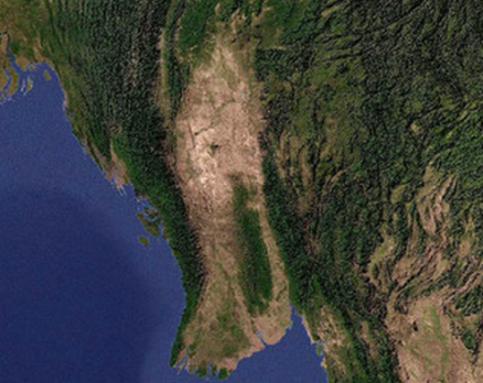
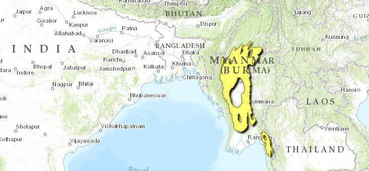
This ecoregion is located within the Irrawaddy River Basin, the catchments of Bago Yoma, and the foothills of Rakhine Yoma. The soils belong to the Irrawaddian series, which consists of the fluvial sands with terrestrial and aquatic vertebrate fossils. Silicified wood fossils are found among ferruginous, calcareous, and siliceous concretions, with quartz pebbles. The Irrawaddian rocks are distinct from other Tertiary rock groups. Their occurrence reaches up to the Kachin State in the north and in Chindwin districts in Sagaing division. The southern distribution is down to Rangoon.
Moist deciduous forests dominate this ecoregion but are found not only in the Irrawaddy River Basin but also throughout the country along the Chindwin, Sittang, and Salween rivers. Topographically the forests are found on well-drained hilly or undulating land up to 1,000 meters (m). The region is best characterized by more than 1,500 millimeters (mm) rainfall interrupted by dry spells. According to Champion's classification, it is moist upper mixed deciduous forest.
The forests are closed high forest. They cover large areas in Pegu Yoma. The westward extension is across Irrawaddy River onto Yakhine Yoma foothills, and the northern extension is up to the Kachin State. Trees reach a height of more than 30 m. The dominant species are teak (Tectona grandis) and Pyinkado or ironwood (Xylia kerri). Species composition is varied and intimately mixed with bamboo groves. In the matrix of deciduous species, some evergreen dominants appear in places.
Common tree species are teak, Xylia kerri, Terminalia tomentosa, T. belerica, T. pyrifolia, Homalium tomentosum, Salmalia insigni, Ginelina arborea, Lannea grandis, Odina wodia, Pterocarpus macrocarpus, Millettia pendula, Berrya ammonilla, Mitravgyna rotundifdlia, and Vitex spp.
Bambusa polymorpha and Cephalostachyum pergracile are the most common bamboos in lower Burma. In the north Dendrocalamus hamiltonii, D. membranaceus, and Cephalostachyum pergracile are common bamboos.
The undergrowth often consists of Leea spp., Barleria strigosa, and other Acanthaceae. Eupatorium odoratum, a noxious weed, colonized the areas when timber extraction left gaps.
Biodiversity Features
Wildlife is intensively exploited outside the protected areas. Most knowledge about the remaining wildlife populations comes from work inside selected national parks. The general trend has been the extirpation of the large charismatic megafauna and the persistent survival of birds and medium-small mammals.
Asian elephants (Elephas maximus) survive in this ecoregion, but their numbers have slowly decreased as the habitat has been fragmented (Land-use and land-cover change). Tigers (Panthera tigris) were common in this ecoregion only fifteen years ago, but severe hunting pressure has nearly extirpated the population. A recent WCS survey using camera traps found no signs of pugmarks or tigers. Eld's deer (Cervus eldi) was thought to survive approximately fifteen years ago at Yinmabin. Today there are no recent signs of Eld's deer in the ecoregion.
Wild species that persist in the ecoregion's national parks include the gaur (Bos gaurus), sambar (Cervus unicolor), serow (Capricornis sumatrensis), golden cat (Felix temmincki), masked palm civet (Paguma larvata), marbled cat (Felis marmorata), leopard cat (Felis bengalensis), spotted linsang (Prionodon pardicolor), Himalayan black-bear (Selenarctos thibetanus), Himalayan sun-bear (Helarctos malayanus), binturong (Arctictis binturong), dhole (Cuon alpinus), and capped langur (Presbytis pileatus). There are no endemic mammals.
|
Table 1. Endemic and Near-Endemic Bird Species. Family Common Name Species Timaliidae White-throated babbler Turdoides gularis An asterisk signifies that the species' range is limited to this ecoregion. Almost 350 birds are found in this ecoregion (Irrawaddy moist deciduous forests) , and they include both water and forest birds found in a wide variety of [[habitat]s]. The forest birds includes several species of woodpecker, laughing thrushes, babblers, orioles, drongos, parakeets, barbets, pigeons, doves, and magpies. Common waterbirds include the red-wattled lapwing (Vanellus indicus), wagtails, sandpipers, forktails, and river chat (Thamnolacea leucocephala). A single near-endemic bird species is found in this ecoregion (Table 1). This ecoregion also corresponds to the Irrawaddy Plains Endemic Bird Area, which contains two restricted-range bird species. In addition to the white-throated babbler, it also identifies the hooded treepie (Crypsirina cucullata) as vulnerable. ==Current Status== {| border="1" cellpadding="3" align="right" ! colspan="3" align="center" | Table 2. WCMC Protected Areas That Overlap with the Ecoregion. Protected Area Area (km2) IUCN Category Alaungdaw Kathapa 1,490 II Kyatthin 230 UA Minwun Taung 140 UA Shwesettaw 340 UA Pegu Yomas [IM0132] 2,220 PRO Total 4,420 Ecoregion numbers of protected areas that overlap with additional ecoregions are listed in brackets. Today the remaining intact forests are found mainly on Pegu Yoma and the northern extension of the ecoregion (Irrawaddy moist deciduous forests) . There are five protected areas in the ecoregion (with IUCN categories I-IV or unknown) (Table 2). Master plans have been drafted for several of these reserves. Unfortunately, they were never approved or implemented. There is an ongoing attempt to establish more protected areas to reach the Forest Policy's mandated target of 5 to 10 percent, but very few effective measures have been taken to manage, protect, and staff the areas that have been established. Therefore, cutting of valuable trees and poaching are rife. The Moyingyi Bird Sanctuary (104 square kilometers (km2)) was established in 1988. It is the water impoundage constructed to irrigate the surrounding paddy fields. Annually thousands of wintering birds arrive in December through February. Therefore, it is imperative to conserve the wetland for the migratory birds. However, the bird [[population] is] now being reduced because of poaching. The protected area, though in place, is not effective. ==Types and Severity of Threats== This ecoregion remains under various threats. Conversion of forests to agriculture and shifting cultivation is prevalent. Illegal cutting of timber, firewood, and nonforest timber products is equally common. Intense poaching of protected animals, such as tigers, for their parts is reducing the population in the remaining forests. The lack of political will to conserve this and other ecoregions in Myanmar essentially permits all these activities to occur without thought of retribution. Hunters and poachers are almost never arrested or punished, and the wildlife protection law exists only on paper. ==Justification of Ecoregion Delineation== MacKinnon's Burmese coast biounit is represented by four [[ecoregion]s]: the Myanmar coastal rain forests, Irrawaddy freshwater swamp forests, Myanmar coastal mangroves, and Mizoram-Manipur-Kachin rain forests. MacKinnon's deciduous forests subunit are represented by the Irrawaddy dry forests and the Irrawaddy moist deciduous forests. The dry, seasonal vegetation in the Irrawaddy Valley is represented by the Irrawaddy moist deciduous forests and Irrawaddy dry forests, which comprise the teak (Tectona grandis)-dominated moist deciduous forests and the drier patches of Dipterocarpus-dominated dry deciduous forests, respectively. The Irrawaddy moist deciduous forests, Irrawaddy dry forests, Chin Hills-Arakan Yoma montane rain forests, Northeast India-Myanmar pine forests, Northern Triangle subtropical forests, and Mizoram-Manipur-Kachin rain forests roughly correspond to Udvardy's Burman rain forest and Burma monsoon forest. ==Additional Information on this Ecoregion== * For a shorter summary of this entry, see the WWF WildWorld profile of this ecoregion. * To see the species that live in this ecoregion, including images and threat levels, see the WWF Wildfinder description of this ecoregion. * World Wildlife Fund Homepage |
|---|


