Intermountain Semidesert Province
Contents
Intermountain Semidesert Province (Bailey)
Columbia-Snake River Plateaus, Wyoming Basin, 159,100 mi2 (412,100 km2)
Land-surface form
This province covers the plains and tablelands of the Columbia-Snake River Plateaus and Wyoming Basin. The plateaus include most of the Northwest's lava fields. Lying at about 3,000 ft (900 m), the plateaus are surrounded by lavas that have been folded or faulted into ridges. To the south, the plateaus grade into the basins and ranges of the Intermountain Desert Province. The Wyoming Basin consists of plains at elevations of 6,000-8,000 ft (1,800-2,400 m) broken by isolated hills and low mountains 1,000-2,000 ft (300-600 m) higher. In the south, broad intermountain basins and isolated small mountain ranges merge into a dissected plateau. Sloping alluvial fans at the edges of the basins merge into flat plains in the center. Badlands are typical of the dissected areas along the region's outer edges.
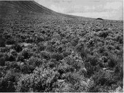 Sagebrush basal plain near Big Butte, Idaho.
 Climate
The climate of the plateaus is semiarid and cool, with an average annual temperature of about 50°F (10°C). Average annual precipitation ranges from less than 10 in (260 mm) in the west (in the rain shadow of the Cascade Range) to 20 in (510 mm) in the east. Precipitation is fairly evenly distributed throughout the year, except during the summer months, when there is little rain.
The higher overall elevation of the Wyoming Basin gives it slightly lower average temperatures and precipitation than on the plateaus. Winters are cold, and summers are short and hot. Average annual temperatures range from 40 to 52°F (4 to 11°C), and the average growing season has fewer than 100 days in the south and 140 days in the north and east. Average annual precipitation ranges from 5 to 14 in (130 to 360 mm), and is fairly evenly distributed throughout the year.
Vegetation
The chief vegetation, sometimes called sagebrush steppe, is made up of sagebrush or shadscale mixed with short grasses. Moist alkaline flats support alkali-tolerant greasewood. Along streams in and near the mountains where the water is good, valley bottoms are lined with willows and sedges, which give way to greasewood and other alkali-tolerant plants as one moves away from the mountains. Lands in the Columbia River Basin with more than 10 in (260 mm) of rainfall per year have an open cover of bunchgrass, and are excellent for raising wheat. A woodland of western juniper covers parts of central Oregon that get little rain.
Soils
This province has extensive alluvial deposits in the floodplains of streams and in the fans at the foot of mountains. Dry lake beds are numerous, and there are extensive eolian deposits, including both dune sand and loess. In the Columbia River Basin, loess deposits are up to 150 ft (46 m) thick, and soils developed from them are correspondingly complex. Aridisols dominate all basin and lowland areas; Mollisols are found at higher elevations.
Soils in the Wyoming Basin are alkaline Aridisols. Subsoils contain a layer enriched with lime and/or gypsum, which may develop into a caliche hardpan. Because the basin is semiarid and weathering is therefore slight, soil texture and composition are governed by parent materials. Entisols are found in the Bighorn basin.
Fauna
Because of its wilderness character, this region supports a great variety of wildlife species. In winter, seasonal changes force many birds and mammals to move from the mountains into the sagebrush semidesert, where they find suitable habitat alongside the area's permanent residents.
Major mammals are coyote, pronghorn antelope, mountain lion, and bobcat. Smaller species include Wyoming ground squirrel, whitetail prairie dog, deer mouse, whitetail jackrabbit, and porcupine. During severe winters, elk and mule deer move into the desert. Moose are locally important in the dense willow thickets along the desert watercourses of eastern Idaho and western Wyoming.
This region is an important breeding and resting ground for migrating waterfowl. Mallards, pintails, green-winged teal, and gadwalls are most common. Canada geese are locally important. Sage grouse are the most abundant upland game bird. The numerous raptors here include Swainson's hawk, ferruginous hawk, rough-legged hawk, red-tailed hawk, marsh hawk, prairie falcon, great horned owl, and burrowing owl.
Reptiles include sagebrush lizard, horned lizard, and prairie rattlesnake.
Return to Ecoregions of the United States
| Disclaimer: This article is taken wholly from, or contains information that was originally published by, the United States Forest Service. Topic editors and authors for the Encyclopedia of Earth may have edited its content or added new information. The use of information from the United States Forest Service should not be construed as support for or endorsement by that organization for any new information added by EoE personnel, or for any editing of the original content. |