Hengduan Mountains subalpine conifer forests
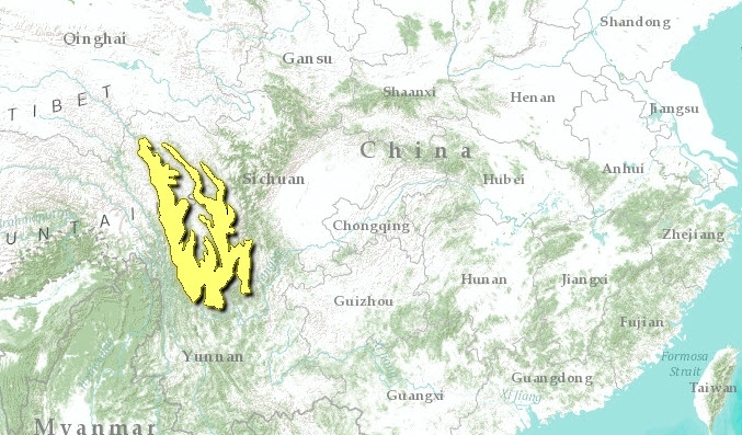
The Hengduan Mountain System includes a complex of ridges and river valleys that rise between the western margin of the Yunnan Plateau and the eastern margin of Tibet. The name Hengduan means "to transect" and this range is, in fact, one of China’s few north-south ranges, cutting perpendicular to the Himalaya. The northern part of the Hengduan system lies to the west of the Sichuan Basin and includes the Min Shan and Qionglai Mountain Ranges. The southern part borders the complex river gorge country where drainages from southeastern Tibet spill out into Southeast Asia. Endangered mammals such as red pandas and musk deer are found in this ecoregion. Commercial logging and illegal wildlife trade are major threats to this area.
Location and General Description
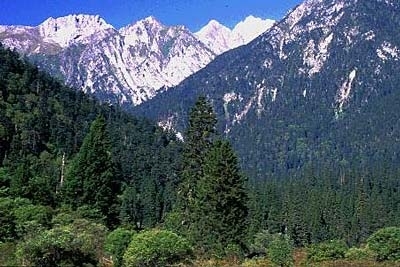
This ecoregion is topographically complex. Parallel mountain ranges are separated by deep, narrowly incised river valleys that support drought-adapted microphyllous scrub vegetation at subtropical elevations (below 2,000 meters (m)). The subalpine zone in the southern Hengduan Mountains is comprised of conifer forests at elevations from 2,800 to 4,000 m. Forests here are dominated by one, sometimes two, conifer species that may emerge from a lower canopy that includes broadleaf taxa such as Rhododendron spp., Acer spp., Betula spp., and Sorbus spp. Distinct forest types have been identified within the southern Hengduan Mountains subalpine forests. These are recognized according to the dominant conifer: hemlock (Tsuga spp.), spruce (Picea spp.), fir (Abies spp.), and larch (Larix spp.).
Spruce forests dominated by Picea likangensis and P. brachytyla occur in the mountains of northwest Yunnan (3,100 to 3,500 m). Forest stands dominated by Abies georgei occur at elevations of 3,500 to 4,000 m.
Larix potaninii is associated with Abies spp.and Picea spp. throughout the region and may form pure stands in some areas. Glacial moraines and other slopes prone to disturbance (usually fire or landslides) may support dense stands of Larix spp. as an early-successional forest type. Here Picea spp. or Abies spp. is likely to comprise the late-successional climax forest.
Conifer forests of the Hengduan mountains tend to be architecturally complex. Broad-leaved trees (both evergreen and deciduous) may form a closed canopy beneath the larger, but more widely spaced conifers. From a distance, it may be easy to overlook the lower canopy, but these smaller-statured trees and large shrubs, especially Rhododendron spp., are usually present. Slender subalpine bamboos (Fargesia spp.) and ferns (Dryopteris spp.) may flourish in the understory, with mosses and lichen on the leaves and culms of the bamboo and a deep, slowly decomposing litter layer rich with fungi. The lichen, Usnea longissima, is abundant in places where moist, cloudy conditions occur during the growing season, hanging from branches and collecting water droplets from fog.
Slopes with a sunny aspect may support oak well into the subalpine zone, at higher elevations than it occurs in most other places. For example, Quercus aquifolioides and other Quercus species grow to 3,500 m or more where they form mixed stands with Abies spp. and Larix spp. in sunny, drier locations. This evergreen oak possesses leathery leaves with a dense, felt-like indumentum on the undersurface. Other Quercus species also occur at these elevations, growing as scrub oaks or small trees.
Forest zonation in the subalpine zone is affected by factors other than elevation. Aspect, soil chemistry and fire history are also important. In general, forests dominated by Picea spp. occur below Abies spp., at elevations of 3,100 to 3,600 m, especially in places that hold winter snow and have persistent cloud cover during the summer. Abies spp. dominates the highest subalpine forests and is widespread at the upper elevations, 3,500 to 4,100 m. Four Abies species occur in the Hengduan Mountains, of which two, Abies georgei and A. delavayi are widespread. Where both Picea spp. and Abies spp. are present, it is possible to recognize the distribution of each at a glance, as Picea spp. is a pale bluish green and Abies spp. appears almost black in color.
Biodiversity Features
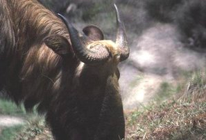
 Takin (Budorcas taxicolor) (Photograph by Bruce Bunting / WWF) Red pandas (Ailurus fulgens) and musk deer (Moschus moschiferus) are two mammal species of conservation significance that inhabit this ecoregion. Red pandas are associated with the subalpine "arrow bamboo" (Sinarundinaria spp.). Musk deer and the elusive and little-known clouded leopard (Neofelis nebulosa) may also occur here. The highly secretive and rarely emerging Lady Amherst’s pheasant (Chrysolophus amherstiae) inhabits dense rhododendron and bamboo scrub.
Nature Reserves in the southern Hengduan mountains include the Yulongxueshan (or Snow Mountain) Nature Protection Area, a scenic area and nature reserve managed primarily for tourism, and Habaxueshan (or Snow Mountain) Nature Reserve. Napahai Nature Reserve, near Habaxueshan, supports a large wetland area that provides important wintering grounds for black-necked cranes (Grus nigricollis) and other waterfowl. Additional wetland habitat (also important for cranes) exists in the part of this ecoregion that lies to the north of the Jinsha Jiand (upper Yangzi River).
Lugu Lake, a deep natural lake set in a landscape of pine-covered highlands at about 2,400 m elevation is a distinctive feature of this ecoregion. The lake supports three endemic species of fish in the genus Schizothorax and one other endemic fish, Otellia acuminata. Lugu Lake is also very important for wintering waterbirds.
Current Status
Much of this ecoregion consists of remote, but unprotected, backcountry. Very little of the habitat here is protected. While the logging ban will aid conservation efforts, more specific management is needed including control of the wildlife trade.
Types and Severity of Threats
Until very recently, commercial logging was responsible for a great deal of deforestation in this ecoregion. In 1998, the Chinese government began to enforce a ban on logging in the mountains of Sichuan and Yunnan Province out of concern that increased erosion in the deforested areas was responsible for increased siltation and flooding on the lower Yangtze River. In southeastern Tibet, such regulations are more difficult to enforce because the local Tibetan government has some limited autonomy to formulate its own policy on politically non-sensitive matters like forest-cutting, and it has chosen not to strictly enforce the logging ban.
The Yulong Nature Protection Area is undergoing rapid tourism development with chair lifts, roads, and recreation facilities. Local villagers earn money from tourists by posing in fictitious ethnic costumes that include pelts of red panda and feathers from Lady Amherst’s pheasant Chrysolophus amherstiae. Merchants in towns throughout the region sell a plethora of wildlife products taken from this ecoregion. These include alpine forbs and cushion plants, a variety of forest mushrooms, bracket fungi, caterpillar fungus (Cordyceps sinensis), bear gall bladder and penis, claws and pelts of large cats, most probably the common leopard, Panthera pardus.
Justification of Ecoregion Delineation
This ecoregion covers the montane areas adjacent to Hengduan Mountains sandwiched between deep river gorges of the Jinsha and the Yalong rivers (tributaries of the Changjiang). Boundaries are formed by CVMCC Vegetation Map of China coniferous forests distributed on ridges along deep river gorges with alpine shrublands at higher altitudes. This is comparable to the Hengduan Mountains and Yalong Plateau biogeographic subunits in the Sichuan-Yunnan Highlands according to Mackinnon et al.
Additional Information on this Ecoregion
- For a shorter summary of this entry, see the WWF WildWorld profile of this ecoregion.
- To see the species that live in this ecoregion, including images and threat levels, see the WWF Wildfinder description of this ecoregion.
- World Wildlife Fund Homepage
Further Reading
- Chinese Vegetation Map Compilation Committee. 1979. Vegetation map of China. Map (1:10,000,000). Science Press, Beijing, China. ISBN: 7030089561
- Jablonski, N.G. editor. 1998. The Natural History of the Doucs and Snub-nosed Monkeys. World Scientific Press. ISBN: 9810231318
- Lancaster, Ro. 1989. Travels in China, a Plantsman’s Paradise. Antique Collectors’ Club Ltd. Woodbridge, Suffolk, England. ISBN: 1851495150
- Li, W. 1993. Forests of the Himalayan-Hengduan Mountains of China and Strategies for their Sustainable Development. International Centre for Integrated Mountain Development (ICIMOD). Kathmandu, Nepal.
- Mackinnon, J., M. Sha, C. Cheung, G. Carey, Z. Xiang, and D. Melville. 1996. A biodiversity review of China. World Wide Fund for Nature, Hong Kong.
- Thomas, A. 1999. Overview of the Geoecology of the Gongga Shan Range, Sichuan Province, China. Mountain Research and Development 19(1): 17-30.
- Wu Zhengyi and the Editorial Board of the Kunming Institute of Ecology. 1995. Vegetation Ecological Landscapes of Yunnan. Forestry Press of China, Beijing. ISBN: 7503811722
| Disclaimer: This article is taken wholly from, or contains information that was originally published by, the World Wildlife Fund. Topic editors and authors for the Encyclopedia of Earth may have edited its content or added new information. The use of information from the World Wildlife Fund should not be construed as support for or endorsement by that organization for any new information added by EoE personnel, or for any editing of the original content. |

