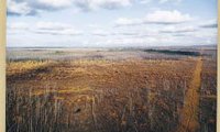
Hudson Plains ecoregion
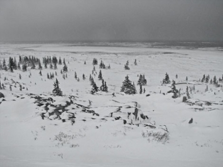
Hudson Bay plain landscape with scattered dwarfed Black spruce trees. @ C.Michael Hogan
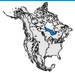 Map of the Hudson Plains region.
 The Hudson Plains ecoregion is centered in northern Ontario and extends into northeastern Manitoba and western Quebec. Wetlands cover 90 percent of this ecological region, making it the largest wetland-dominated area of North America. In fact, this region contains the longest stretch of shallow, emergent wetland shoreline on Earth. The population of 10,000 is largely aboriginal. Hunting, fishing and trapping with some ecotourism are the region's major economic activities. Prehistory of the area includes settlement by Paleoeskimos and subsequent tribal conflict even before Europeans arrived in the region.
Physical Setting
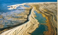 Beach striation and wetlands along the coast of Hudson Bay. Source: Ed Wiken
 This lowland plain is underlain by flat-lying Paleozoic and Proterozoic sedimentary rocks, which slope gently towards the Hudson and James bays. Elevations rarely exceed 500 metres (m) above sea level. The surface is characterized by extensive wetlands, including peatlands (chiefly bogs and fens) and shallow open waters less than two meters deep. Isostatic rebound is considerable along the coast of Hudson and James Bays, where the land rises approximately one metre per century. Some 7500 years ago, this region was covered with sea water as part of a much larger Hudson Bay. Well-drained, raised beach strands, coastal marshes (Tidal marsh) and tidal flats currently typify this coastline. Organic soils predominate. Young, poorly-developed saline soils occur on silty to clayey marine sediments along the coastal shore. The permafrost ranges from continuous in the northwest to isolated patches in the southeast.
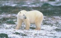 Polar bears range throughout the Hudson Plainsand other northern ecological regions. Source: CEC File
 The climate is strongly influenced by the cold and moisture-laden Hudson Bay low-pressure and polar high-pressure air masses. The short, cool summers and very cold winters reflect a cold continental climate. Mean annual temperatures range from –7°C to –2°C. Mean summer temperatures range from 11°C to 14°C but mean annual winter temperatures range between –19°C and –16°C. Precipitation annually ranges from 400 millimetres (mm) in the northwest to 800 mm in the southeast.
Biological Setting
 Wetlands and Forests of the Hudson Plains. Source: Ed Wiken
 Vegetation types consist of tundra and transitional boreal forests. The poorly drained areas support dense sedge/moss/lichen cover, and the less frequent and better-drained sites support woodlands of black spruce and tamarack. The raised beaches present a striking pattern of successive black spruce-covered ridges alternating with depressions, bogs and fens. Characteristic terrestrial mammals include woodland caribou, white-tailed deer, moose and black bear. The ecological region is an important habitat for breeding waterfowl, particularly Canada geese. Ducks common to this region include eiders, mergansers, scoters and black. The adjacent marine environment includes Bearded seals, Harbour seals and Ringed seals, as well as Bowhead whales and Beluga whales in the summer. Polar bears are present as both terrestrial and marine mammals.
Human Activities
 Fishermen on the beach in northern Ontario. Source: Ed Wiken
 The resources utilised in this region have historically related to aboriginal hunting, trapping and fishing and, in many ways, continue that way. Large-scale hunting and trapping took place from the late 1600s, when the Hudson’s Bay Company began to establish stockaded trading posts on the shores of Hudson Bay—an on-going venture until the 1900s. Today, commercial trapping is minimal. Economic activity is now concentrated on localized sport fishing and tourism. The largest center, Churchill, serves as a major port for ocean transport of wheat and potash from the Prairies to overseas destinations. Other major communities include Fort Severn, Attawapiskat and Moosonee, resulting in an overall regional population of 10,000.
References
- Torsten Bernhardt. Hudson Plains. Canada's Ecozones, Canadian Biodiversity project. McGill University, Redpath Museum
- Bird Studies Canada. Taiga Shield and Hudson Plains. Canadian Bird Conservation Regions.
- Environment Canada. The Wetlands. Hudson Plains Ecozone. .
- C.Michael Hogan. 2008. Polar Bear: Ursus maritimus, Globaltwitcher.com, ed. Nicklas Stromberg
| Disclaimer: This article contains some information that was originally published by the Commission for Environmental Cooperation. Topic editors and authors for the Encyclopedia of Earth have edited its content and added new information. The use of information from the Commission for Environmental Cooperation should not be construed as support for or endorsement by that organization for any new information added by EoE personnel, or for any editing of the original content. |