Gunung Mulu National Park, Malaysia
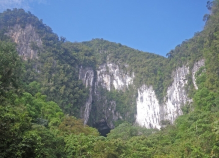
Limestone cliffs above Deer Cave, Mulu National Park. @ C.Michael Hogan
Gunung Mulu National Park is a World Heritage Site in the state of Sarawak in Malaysia, situated at 3°56'-4°16'N, 114°47'-115°00'E.
Contents
- 1 Geographical Location
- 2 Date and History of Establishment
- 3 Area
- 4 Land Tenure
- 5 Altitude
- 6 Physical Features
- 7 Climate
- 8 Vegetation
- 9 Fauna
- 10 Cultural Heritage
- 11 Local Human Population
- 12 Visitors and Visitor Facilities
- 13 Scientific Research and Facilities
- 14 Conservation Value
- 15 Conservation Management
- 16 IUCN Management Category
- 17 Further Reading
- 18 See Also
Geographical Location
The nominated World Heritage Site is located on the island of Borneo, in northern Sarawak, Malaysia approximately 110 kilometers (km) west of the coastal town of Miri. It lies between the headwaters of the Tutuh River, a tributary of the Baram River, in the Fourth administration Division of Sarawak, and the Medalam River, a tributary of the Limbang river in the Fifth Division. The park therefore spans a watershed between the fourth and fifth administration Divisions of Sarawak, with the northwest boundary of the Park lying along the international boundary with Brunei Darussalam. Geographical coordinates for the park are: 3°56'-4°16'N, 114°47'-115°00'E.
Date and History of Establishment
 Gunung Mulu National Park. (Source: Georgia Institute of Technology)
 Gunung Mulu National Park was first constituted on 3 October 1974, under Gazette Notification No. 2852 of the National Parks Ordinance (1956). The park opened to the public in 1985.
Area
The nominated site extends over an area of 52,864 hectares (ha) (528 square kilometers ); the park is contiguous with the Medalam Protected Forest (12,500 ha).
Land Tenure
This National Park is owned by the government of Malaysia..
Altitude
The topography within the park ranges from 28 meters (m) to 2377 m above sea level (the summit of Gunung Mulu the second highest mountain in Sarawak).
Physical Features
The nominated site contains a wide range of landforms. Gunung Mulu lies in the north-west Borneo geosynclinal belts and the geology includes all the major lithological units. Examples of landforms include steep ridges and escarpments, karst phenomenon (towers, caves, terraces and floodplains). Other natural phenomena include the Terikan River hot springs and many waterfalls, particularly in Melinau Paku Valley.
Three Tertiary rock formations are evident on the site, the Mulu Formation, Melinau Limestone Formation and the Setap Shales. The Mulu Formation emerges over the whole southwestern part of the park, comprising of a 4000 to 5000 meter (m) thick series of shales and sandstones, that includes the Gunung Massiff, which rises to 2377 m.
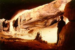 Cave at Gunung Mulu. (Source: Forestry Department of Sarawak, Malaysia)
 Karstic limestone of the Melinau Formation occurs on the western flank of Gunung Mulu. A line of karst hills and [[mountain]s] (consisting of Gunung Api, Gunung Benarat, and Southern Hills) up to 1,500 m thick dating from the Upper Eocene, Oligocene and Lower Miocene ages, rise to an altitude of 1,682 m (the summit of Gunung Api). Many of the mountains have vertical cliffs, and rounded or spined summits. Melinau George divides Gunung Api from Gunung Benarat, while Gunung Benarat and Gunung Buda are separated by Medalam Gorge. The limestone that constitutes the mountains is extremely pure, consisting of white or grey calicutite and calcarenite that is massively bedded and jointed.
The Setap Shale Formation dates from the Miocene period. It occurs as a gentle line of hills in the north-west of the park, consisting of clay-shales in the valleys and siltstones and quartzite sandstone on the scarps.
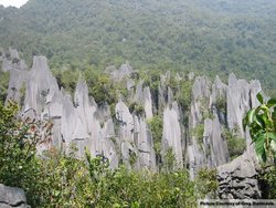
The park is extremely rich in cave resources, as a result of geological uplift in the karst formation 2-5 million years ago, and the erosion of karst phenomenon by rivers in the area. The caves that have been created are some of the largest found anywhere in the world, and are superb examples of tropical river caves with flood incuts, extensive clastic sediment deposits and ellipticle tubes linking different cave levels. As well as caves, razor-edged "pinnacles" are a feature of the mountains, particularly on the north-east side of Gunung Api.
Over 295 km of the caves in the park have been explored and mapped, and a number of them are globally unique. Deer Cave (Gua Payau) is the world’s largest natural cave passage, measuring 120-150 m in diameter. Located in the south-eastern part of Gunung Api, Sarawak Chamber is the world’s largest natural chamber within a cave (Gua Nasib Bagus – Good Luck Cave). The chamber measures 600 m long, 415 m wide and 80 m high and could contain 8 Boeing 747 aircraft lined up nose to tail. The "Clearwater Cave System" measures 108 km in length and is believed to be the eleventh longest cave system in the world, as well as containing the longest cave in Asia. Due to the complex alluvial history of the Melinau river and its tributaries, passages have been developed at many levels. Clearwater Cave and Green Cave contain the largest examples of photo-kast in the world. In addition Clearwater Cave contains the largest windblown stalacite, at over 1 m in length. Stromatolites are also common at all the cave entrances. Exploration of the entire Clearwater Cave System is still underway.
Climate
The area is influenced by the north-east monsoon between December and March, and the southwest monsoon between May and October. Rainfall is generally high, with seasonal averages ranging from 4000 to 5000 millimeters (mm). There is no marked dry season, although rainfall does show distinct seasonality, being highest from April to May and October to November, and lowest between August and September. Mean and maximum temperatures in the Melinau lowlands range from 23ºC to 26ºC and at Gunung Mulu between 14 degrees Celsius (ºC) to 18ºC.
Vegetation
A wide range of soil types and altitudes occur in the nominated site, thus a wide diversity of vegetation formations are represented. Seventeen vegetation zones have been recognized, over 3500 plantspecies listed and 1500 flowering plants identified. The site is considered a Centre of Plant Diversity.
On the Gunung Massive, multi-storied mixed lowland dipterocarp forest occurs up to an altitude of 800 m. Within three plots covering a total area of 1.2 ha, 284 tree species have been recorded. Common species include Shorea, Durio, Garcinia, Calophyllum and Eugenia. This forest represents one of the most diverse in Malaysia. Between 800 to 1,200 m lower montane forest, dominated by Quercussubsericea. Upper montane forest displaces this between 1,200 m to 2,177 m, although it is further sub-divided (tall facies, short facies and summit facies) as altitudes increase. The small tree and shrub layer is represented by four species of Rhododendron and Vaccinium and pitcher plants Nepenthes lowii, N. tentaculata and N. muluensis that are endemic to Gunug Mulu.
On the Melinau Limestone Formation, examples of limestone forest occur. This includes limestone scree forest, limestone cliff vegetation, lowland limestone montane forest, upper montane limestone forest and limestone cave vegetation. Many endemic calcerous species are represented in this area; the limestone flora is one of the most diverse and best preserved in Southeast Asia. Examples of such species include Gesneriaceae such as Monophyllae beccarii, M. horsfieldii and Cytandra spp. The palm Salacca rupicola endemic to limestone; occurs ledges and sills.
The alluvial plain in the park comprises of lowland alluvial forest, tropical heath forest, peat swamp and riparian forest. It is the most complex vegetation formation in the park. Some emergent species attain a height of 40 m, with maximum girths of 250 m.
Gunung Mulu National Park is considered to be one of the richest sites in the world for palms, with approximately 111 species and 20 genera recorded. Of particular significance is Wild sago palm Eugeissona utilis, that occurs on the steep slopes of Gunung Mulu; Iguanura melinauensis and Licuala lanata are endemic to the alluvial plain; Calamus Neilsonii and Salacca rupicola are endemic to the limestone and Areca abdulrahmanii occurs on the Setap shales.
1,700 species of liverworts and mosses have been recorded. Examples of endemic mosses to the park include Stereodontopsis flagellifera, Coryphopteria andersonii, Hypnodendron beccarii and H. vitiense. The very rare bogmoss Sphagnum perichaetiale can be found in rain gullies in the high forest. There are also a great number of Pteridophytes, spore producing plants, occurring in the park. To date 442 species have been identified, many of which are ferns. In addition 4000 species of fungi have been recorded. A floral inventory can be found in Anderson et al.
Fauna
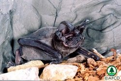 Wrinkle Lipped Bat. (Source: Agriculture, Fisheries and Conservation Department of Hong Kong)
 A diverse range of faunal species have been recorded within the nominated site, including 81 mammalian species, 270 species of birds, 20,000 species of invertebrates, 55 reptile species, 76 species of amphibians and 48 species of fish. This is only a small proportion of the total number of estimated species.
Important mammal species such as the Malayan Pangolin Manis javanica, 28 species of bats, two species of endemic Borneo squirrels, the tufted ground squirrel, Rheithrosciurus macrotis, and the plain pigmy squirrel Exilisciurus exilis have been identified in the park. The smallest mammal in the world, the Savi’ pigmy shrew, Suncus etruscus, weighing only two grams is also found.
To date 28 species of bat have been identified in the park, one of the highest number in South East Asia. Research on the animal is on-going, with more species likely to be recorded in future. Deer Cave contains one of the world’s largest colonies of free tailed bats, the wrinkle-lipped bat Charrephon plicata, numbering approximately three million. This cave also contains the largest number of different bat species in any cave, 12 have been identified to date. The lesser tailess round leaf and the orange-tube nosed bat are examples of bats occurring in the nominated site that have not been seen anywhere else in Borneo.
Malaysia has 736 species of bird within its territory, 270 bird species have been recorded in Gunung Mulu. Of the 29 endemic Borneo species, 26 have been recorded in the park area. Eight of Borneo’s hornbill species have been identified including the wrinkled hornbill Rhyticeros corrugatus. Other species include Bulwer’s Pheasant Lophura bulweri, crested fire back pheasant L. ignita, Storm’s stork Ciconia stormi, and the bamboo muni which is endemic to Borneo and has only been found in Mulu and Kinabalu.
Cave fauna including many troglobitic species is also abundant, with over 200 species recorded. Many of the cave fauna species are endemic, with 41 on the endangered species (IUCN Red List Criteria for Endangered) list. Several million cave Swiftlets Aerodramus sp., have been recorded from one cave formation, the largest colony in the world. Many invertebrates including cave fauna are endemic to the nominated site. Lepidotera are particularly well represented, with 80 percent of Borneo species recorded. Endemics include Celastrina ssp.
A total of 25 snake species have been recorded and include regal python Python reticularus, reed snake Calamaria borneensis and C.melanota. Poisonous snakes include the banded-coral snake Maticora intestinalis, the red headed krait, Bungarus flaviceps and the white-spotted cat snake Boigo drapiezii. Two-thirds of all known amphibian species occurring in Borneo can be found at the nominated site, including Wallace’s flying frog. Of particular significance is the Philautus spp., that only breeds in the fluid of the pitcher plant. Twenty-seven species of lizard have been identified. A faunal inventory is available in Anderson et al., as well as in the Nomination document.
Cultural Heritage
The Penan and Berawan indigenous people live adjacent to the park boundaries. Both groups still have hunting and collecting privileges in subsistence hunting zones within the park. Excavations from Wind Cave by the Sarawak Museum have revealed artifacts and human remains believed to date from 3000 to 500 years before present. The cave is believed to have been used as an ancient burial site, with many of the artifacts being identical to those found at similar sites in the region. Research is still far from complete and may yield other discoveries.
Local Human Population
The Penan people are found as semi-settled and nomadic groups along the borders of the park and on its boundaries. Two long houses exist along the south-western perimeter of the park at Batu Bungan and Long Iman, a number of Penan are settled here. A nomadic group of this tribe live in the eastern part of the park. The exact number of inhabitants here is currently unknown, however it is thought that it is no more than 10 people.
Visitors and Visitor Facilities
Access to the park is by boat along the Baram and Tutuh Rivers or by air from Miri, Limabang and Brunei Darrusalem. Over 15,000 tourists visit Gunung Mulu National Park annually. Fifty percent are foreign nationals. All visitors require a park permit to enter the park, and must be accompanied by a Park guide.
The Park Headquarters are located on the left bank of the Melinau River, this is the administration focal point for the park. Visitor facilities here include an interpretation center, an audio-visual room, visitor registration building and washroom facilities. Additional facilities are located in the park.
Four caves (Deer Cave, Lang’s Cave, Wind Cave and Clearwater Cave) have been developed for visitors with cement, timber walkways and electric lighting. In addition seven wild cave trails are open to visitors for adventure caving activities. Restrictions on activities are imposed. An extensive number of hiking trails totaling 37.9 km has also been developed.
A variety of accommodation is available for visitors including the 188 room Royal Mulu Resort, 4 chalets, a guest house, hostel accommodation and 4 timber framed buildings. All facilities are concentrated around the park entrance.
Scientific Research and Facilities
Botanical collections have been made in the area since 1961, specimens form which are housed in the Forest Herbarium at Kuchung. The Royal Geographical Society conducted a 15 month long expedition to the park in 1977/78. There have been several caving expeditions to the park, during which the cave systems in the southern portion of the park have been extensively explored. Substantial research has been carried out relating to cave fauna, this has provided a valuable insight into the ecology of such areas in the tropics, and particularly South East Asia.
Conservation Value
The nominated World Heritage Site provides significant and unique tropical cave and karst features and ecosystems, in a relatively undisturbed state. It is a significant site in terms of its biology, geology and geomorphology. The assemblage of plants and animals shows very high endemism and biodiversity in a relatively unaltered setting. The site is valuable for baseline studies of ecosystem processes in the humid tropics. In addition the combination of alluvial, sandstone and limestone ecosystems is unique in South East Asia and provides opportunities to understand long-term ecosystem dynamics, landscape ecology and the impacts of visitors on tropical protected areas.
Conservation Management
A number of management plans have been produced for the nominated site. The first Management and Development plan was prepared in 1982 by J.A.R Anderson and the Earl of Cranbrook. This was followed by a second management plan in 1992, compiled by the Sarawak Forest Department. This covered activities between 1993-1995. A third management plan is currently being prepared.
High density, low density, traditional use and wilderness zones have been created in the park. High density zones are concentrated around the Park Headquarters and four show caves and four other caves. Visitors are restricted to paths and strict rules governing visitor behavior are imposed, thus minimizing disturbance to the caves and their fauna. Group size is limited to 10 people for the show caves, visiting at 20 minute intervals. Low density zones include the trails and caves open for adventure caving activities. Group size to these areas is limited to six people and one guide, and total carrying capacity for the zones restricted to 60 people per day. Traditional zones are for subsistence hunting and gathering of forest produce. Wilderness zones include 95% of the nominated site’s caves. The general public is not allowed access to these zones, and research is only allowed with permission from the Director of Forests.
Three extensions to the National Park have been proposed. These include the Medalam extension to the north, which would constitute a new National Park covering 6,235ha (Gunung Buda National Park). The proposed Ubung extension on the eastern boundary of the nominated site, covers an area of 16,177 ha and protects the Tutuh River. The Lutut extension is proposed on the western boundary of Gunung Mulu National Park, and will protect the Lutut River, a tributary of the Melinau River. If successful these areas would act as a buffer zone for the park.
Management Constraints
Potential threats to the integrity of the nominated site arise from logging, forest fires and development adjacent to its boundary. Some logging activities are known to have occurred just inside the park boundary, these are hard to detect. The park management authority realizes that there is a need to increase boundary patrols by foot and helicopter, up to four times a year.
During 1997-1998 there were substantial man-made forest fires in Sarawak, originating from small-scale land clearings by local farmers. These were made worse as a result of the severe drought caused by El Niño. Gunung Mulu National Park was not affected by this however natural forest fire destroyed a considerable area of Gunung Api, Gunung Benarat and Gunung Buda in 1997. Natural forest fires are a phenomenon that have historically played an important role in the natural regeneration of vegetation in the area. Other natural disturbances such as flooding, forest damage caused by tropical storms and landslides also occur periodically.
Development outside the park has resulted in a number of problems, namely the pollution of parts of the Melinau River and severe erosion of the riverbanks due to forest clearance for housing development and rice cultivation.
Staff
Where possible, staff are recruited directly from the local community, including Penan and Berawan indigenous groups. The park currently employs 47 people, 40 of which are from the locality. Exact details relating to staff and management structure is unavailable, however the number employed exceeds the recommended staffing levels (38 people), suggested by Anderson et al., in 1982.
Budget
Over US$157,916 per year is spent by the government on salaries and local contracts. Additionally, in 1998 US$394,789 was spent on redevelopment and maintenance projects in the park.
IUCN Management Category
- II (National Park)
- Natural World Heritage Site (proposed) – Criteria i, ii, iii, iv
Further Reading
Over 40 references have been provided with the nomination document, a selection of texts are identified below:
- Anderson, J.A.R, Jermy, A.C. and The Earl of Cranbrook. 1982. Gunung Mulu National Park. A management and development plan. IUCN/WWF Project 1576. Royal Geographical Society. 345pp
- Anderson, J.A.R. and Chai Piang Kong, P. 1982. Vegetation. Gunung Mulu National Park, Sarawak. Sarawak Mus. J. XXX. No. 51 Part 1. 195-206
- Barr, T.C. 1968. Cave ecology and the evolution of troglobites. Evolutionary Biology. 2. 35-102.
- Brook, D.B., Eavis, A.J. and Lyon, M.K. 1982. Caves of the Limestone. Gunung Mulu National Park, Sarawak. Sarawak Museum Journal.XXX. No 51. Part 1. 95-120
- Chapman, P. 1980. The biology of caves in the Gunung Mulu National Park, Sarawak. Trans. Bit. Cav Res. Assoc. Vol. 7. 141-149.
- Chapman, P. 1982. The Ecology of caves in the Mulu National Park, Sarawak. Cave Science, Trans. Bit. Cav Res. Assoc. Vol. 9. 142-162.
- Chapman, P. 1984. The Invertebrate Fauna of the caves of Gunung Mulu National Park, Sarawak. Gunung Mulu National Park, Sarawak. Sarawak Mus. J. XXX.No. 51.Part11. 1-1
- Cramphorn, J. 1982. A preliminary list of fish recorded in the Gunung Mulu National Park. In: Anderson, J.A.R, Jermy, A.C. and The Earl of Cranbrook. Gunung Mulu National Park Management and Development Plan. Royal Geographical Society, London. 295
- Cranbook, Earl of. 1982b. Birds recorded within Gunung Mulu National Park. In: Anderson, J.A.R, Jermy, A.C. and The Earl of Cranbrook. Gunung Mulu National Park Management and Development Plan. Royal Geographical Society, London. 285-290
- Cranbook, Earl of. 1982a. Mammals recorded within Gunung Mulu National Park. In: Anderson, J.A.R, Jermy, A.C. and The Earl of Cranbrook. Gunung Mulu National Park Management and Development Plan. Royal Geographical Society, London. 284-293
- MacKinnon, J. and MacKinnon, K. 1986. Review of the protected areas System in the Indo-Malayan Realm. IUCN, Gland, Switzerland and Cambridge, UK and UNEP. 284pp. ISBN: 2880326095.
- Dring, J.C. and Kiew, B.H. 1982a. Reptiles recorded within Gunung Mulu National Park. In: Anderson, J.A.R, Jermy, A.C. and The Earl of Cranbrook. Gunung Mulu National Park Management and Development Plan. Royal Geographical Society, London. 291
- Dring, J.C. and Kiew, B.H. 1982b. Frogs recorded within Gunung Mulu National Park. In: Anderson, J.A.R, Jermy, A.C. and The Earl of Cranbrook. Gunung Mulu National Park Management and Development Plan. Royal Geographical Society, London. 291pp.
- Gill, D.W. 1998b. Sarawak’s Cave Fauna. Hornbill, Proceedings of a Workshop on Sarawak’s National Parks and Wildlife, Forest Department, Sarawak. 2-14
- Hacker, B. (Ed). 1995. The Caves of Gunung Buda. Caves of Gunung Buda: Report of the Sarawak Forest Department and USA Caving Expedition. 63pp
- Hall, L.S. 1996. Observations on bats in Gua Payau (Deer Cave), Gunung Mulu National Park, Sarawak. Sarawak Mus. J. No. 71. 111-124
- Rose, J. 1982. The Melinau River and its terraces. Transactions of the British Cave Research Association. 9. 113.
- Walsh, R.P.D. 1983. Climate of the Gunung Mulu National Park. Sarawak Mus. J. No. 30. 34-68
- WWF & IUCN. 1994-1995. Centres of Plant Diversity - A guide and strategy for their conservation. 3 volumes. IUCN Publication Unit, Cambridge. ISBN: 2831701988.
See Also
| Disclaimer: This article contains information that was originally published by the United Nations Environment Programme-World Conservation Monitoring Centre (UNEP-WCMC). Topic editors and authors for the Encyclopedia of Earth have edited its content and added new information. The use of information from the United Nations Environment Programme-World Conservation Monitoring Centre (UNEP-WCMC) should not be construed as support for or endorsement by that organization for any new information added by EoE personnel, or for any editing of the original content. |