Communities (Gulf of Mexico)
Contents
Gulf of Mexico
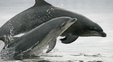
Bottlenose dolphin mother and calf in the Gulf of Mexico. Credit: USFWS
Seas of the World ![]() The Gulf of Mexico is a western arm of the Atlantic Ocean, it is an ocean basin generally circumscribed by the land, including the USA, Mexico and the island of Cuba; it can be considered as the eleventh largest surface water body on Earth.
The Gulf of Mexico is a western arm of the Atlantic Ocean, it is an ocean basin generally circumscribed by the land, including the USA, Mexico and the island of Cuba; it can be considered as the eleventh largest surface water body on Earth.
Delimited on the northeast, north and northwest by the Gulf Coast of the USA, on the southwest and south by Mexico, and on the southeast by Cuba, the basin shape is approximately ovate and with a width of about 1500 kilometers; the basin bottom is largely filled with sedimentary rocks and debris.
It is connected to the Atlantic Ocean via the Florida Straits that run between the USA and Cuba, and with the Caribbean Sea, connected by the Yucatan Channel between Mexico and Cuba. With this thin neck connection to the Atlantic, the gulf experiences quite small tidal ranges. The basin volume is approximately 1.6 million km², with virtually half in shallow intertidal waters.
At its deepest, the Gulf of Mexico reaches a depth of 4384 meters at a point known as the Sigsbee Deep, a jagged trough exceeding 550 km in length. The Gulf of Mexico contains a volume of about 660 quadrillion gallons.
The United States portion of the Gulf of Mexico (GOM) region extends from the Florida Keys westward to the southern tip of Texas, following the coastline of five states. The combinedcoastline of these states totals over 47,000 miles (when including the shores of all barrier islands, wetlands, inland bays, and inland bodies of water). The Gulf of Mexico has an area of approximately 580,000 square miles, contains an approximate 584,000 cubic miles of water, and has an average depth of 5299 feet (Nipper et al., 2008).
This article provides a snapshot of current data available and is intended to highlight a variety of socioeconomic and environmental attributes of the GOM region. Economic activities are not necessarily ocean or coastal dependent, but serve the residents of and visitors to these coastal areas. The 2005 hurricane season had a sizable impact on the Gulf of Mexico’s communities, economy, and ecology.
Throughout this article, data are presented at several levels of geography: region, state, and coastal county. For the purposes of this report, GOM coastal counties were chosen to represent what is hereafter referred to as the “Gulf Coast Region.” To be included as “coastal,” one of the following criteria must be met: (1) at a minimum, 15% of the country’s total land area is located within a coastal watershed or (2) a portion of or an entire county accounts for at least 15% of a U.S. Geological Survey coastal cataloging unit. The Gulf Coast Region contains a total of 141 coastal counties across the five U.S. Gulf States.
Geology 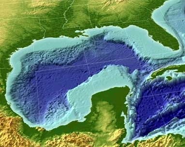
The Gulf of Mexico basin is thought to have originated in the Late Triassic time as the result of rifting within the North American Plate, when that plate commenced to crack and drift away from the African and South American Plates. Rifting likely continued through Early and Middle Jurassic time with the formation of a stretched continental crust throughout the central part of the basin. Intermittent advance of the sea into the continental area from the west ring late Middle Jurassic time resulted in the formation of the expansive salt deposits, including the Louann Salt. The principal drifting episode, during which the Yucatan block moved southward and separated from the North American Plate and true oceanic crust formed in the central part of the basin, took place during the early portion of the Late Jurassic, after the salt deposit formation.
Since the Late Jurassic, the Gulf of Mexico has endured as a stable geologic province characterized by the persistent subsidence of its center, which likely first occurred from thermal cooling and later continued from sediment loading as the Gulf filled with thick prograding clastic wedges along its northwestern and northern margins, particularly during the Cenozoic. The stable Florida platform at the eastern boundary was not inundated until the Late Jurassic or early Cretaceous. On the western side the Yucatan platform was above sea level until the mid-Cretaceous. After both platforms were submerged, the formation of carbonates and evaporites has depicted the geologic history of these two stable delimiters.
Circulation and currents
Water enters the Gulf through the Yucatan Strait, circulates as the Loop Current, and exits through the Florida Strait eventually forming the Gulf Stream. Portions of the Loop Current often break away forming eddies or gyres which affect regional current patterns. Smaller wind driven and tidal currents are created in nearshore environments.
Drainage into the Gulf of Mexico is extensive and includes 20 major river systems (>150 rivers) covering over 3.8 million square kilometers of the continental United States. Annual freshwater inflow to the Gulf is approximately 10.6x10¹¹ m3 per year (280 trillion gallons). 85% of this flow comes from the United States, with 64% originating from the Mississippi River alone. Additional freshwater inputs originate in Mexico, the Yucatan Peninsula and Cuba.
Resources
The Gulf of Mexico ecosystem provides a wide array of valuable resources to the nations on its shores. Brief summaries of petroleum and fisheries resources can be found below.
Physical / Mineral
It is estimated that 1.4-7.2x10⁸ barrels of petroleum and 4.4-22.3x10¹⁰ cubic meters of natural gas are present beneath the seafloor in the northern Gulf . According to the Minerals Management Service, offshore operations in the Gulf produce a quarter of the U.S. domestic natural gas and one-eighth of its oil. In addition, the offshore petroleum industry employs over 55,000 U.S. workers in the Gulf. In Mexico, the Secretariat of Energy (Secretaria de Energia - SENER) estimated that the daily crude oil and natural gas production from Gulf of Mexico offshore operations in the years 2000 to 2005 ranged from 2.293 to 2.839 million barrels and 41.4 to 44.8 million cubic meters, respectively.
Fisheries
Gulf fisheries are some of the most productive in the world. In 2000, the commercial fish and shellfish harvest from the five U.S. Gulf states was estimated to be 1.7 billion pounds (approximately 772 million kg), which represents almost 1/5 (19.4%) of the total domestic landings in the United States. In the same year, commercial catches in the Gulf represented approximately 25% of the total U.S. domestic commercial fishing revenue and were valued at over $900 million. The Gulf also supports a productive recreational fishery. Excluding Texas, U.S. Gulf states accounted for over 40% (>104,000 lbs or >47,000 kg) of the U.S. recreational finfish harvest in 2000.
Water pollution
Several types of water pollution are notable historically in the Gulf of Mexico, including natural sources of both, such as algal blooms and release of crude oil from wellheads on the sea floor.
Algae blooms
Algae blooms called red tides have periodically occurred off the southwest and southern Florida coast, from the Florida Keys to north of Pasco County, Florida. These blooms cause mortality to fish and marine mammals; moreover, they may induce respiratory illness in people and terrestrial mammals when the red tides are near shore.
Bay of Campeche blowout
The Ixtoc I oil rig had a blowout in June 1979 within the Bay of Campeche suffered a blowout, which produced a major explosion and significant oil release which persisted for nine months before successful capping of the well. This event was ranked as the largest oil spill in the Gulf of Mexico until the Deepwater Horizon oil spill in April 2010. In 2008, scientists revealed that there was an extensive dead zone with an east/west axis extending from Venice, Louisiana to Galveston, Texas. This dead zone virtually doubled in size between 1985 and 2008.
Deepwater Horizon crude oil release
The Deepwater Horizon oil release occurred in the bathypelagic zone, approximately one mile deep. The crude oil release was accompanied by an explosion on the Deepwater Horizon offshore oil platform 40 miles southeast of the Louisiana coaston April 20, 2010. The magnitude of this release is expanding as of late May, 2010, with a total release to date estimated greater than three million barrels of crude oil, making this incident the largest oil spill in the Gulf of Mexico.
History
The prehistory of the Gulf of Mexico region is dominated by a number of Native American peoples who inhabited the Gulf perimeter. A notable example of these peoples was the Hopewell civilization who built great mounds along the entire Mississippi Valley extending south to the Gulf environs in the period 300 BC to 600 AD.
An Italian explorer, Amerigo Vespucci, was the first European to visit the Gulf of Mexico in the year 1497. Vespucci also traced a course along the Caribbean coast during this voyage, and a map depicting Cuba as an island resulted from this early exploration of the Gulf.
In 1506 the Spanish explorer Hernán Cortés was involved in the conquest of Hispaniola and Cuba, and received a sizable tract of land and Indian slaves as a reward for his military success. In 1518 Velázquez placed Cortes in command of an expedition to explore and secure the interior of Mexico for colonization. In the year 1517 Francisco Hernández de Córdoba visited the Yucatán Peninsula. This represented the first European encounter with a highly advanced civilization in the Americas, with stone architecture and a complex cultural society, which the Spanish recognized as comparable to those of the Old World; they also believed that this new land would hold gold. All of this encouraged two follow-up expeditions, the initial one in 1518 under the command of Juan de Grijalva, and the second in 1519 under the command of Cortés, which led to the Spanish exploration, invasion and the conquest of Mexico.
Gulf Communities
Coastal regions are among the most densely populated areas in the Nation. Compared to other coastal regions within the United States, the Gulf Coast Region has experienced a considerable population increase since 1970, growing by 103%. This is the second fastest-growing region just behind the Southeast Coast Region, increasing faster than both the Pacific and Northeast Coast Regions. The GOM region is also home to frequent hurricanes, which can adversely affect a growing population. Hurricanes Katrina and Rita displaced thousands of people both temporarily and permanently in 2005. Additionally, the Gulf Coast Region has experienced both tremendous housing unit growth and loss compared to other coast regions in the United States. Fortunately, the Gulf Coast Region’s population is rebounding from these events. This section of the article presents population, housing trends, and projections.
Population
 Population density in the Gulf Coast Region by state. Credit: Woods and Poole Economics, Inc., 2007. Population density in the Gulf Coast Region by state. Credit: Woods and Poole Economics, Inc., 2007.
|
The Gulf Coast Region is increasingly becoming an attractive area for both retirees and job hunters, offering a pleasant climate and new opportunities for its residents. This region has shown a considerable rate of growth over the past 40 years and is expected to grow at this rate in the upcoming decades.
The total population of the Gulf Coast region is approximately 20,528,556 (as of 2008), with slightly more women than men at a ratio of 51:49. Approximately 25% of this population is considered part of the “baby boomer” generation. Of this “baby boomer” population, approximately 65% will reach retirement (age 65) by 2015. The average median age is 38 years.
The population density of the Gulf Coast Region is 178 persons per square mile. The U.S. coastal county population density is 311 persons per square mile (excluding Alaska). Pinellas County, FL, is the leading county in the Gulf Coast Region in terms of population density, averaging 3,365 persons per square mile. The total number of households in the region is 8,086,400, at an average size of 2.6 persons. The mean household income is $77,068, and 57% of the population is employed (compared to 60% nationwide).
The Gulf Coast Region is the second leading U.S. coastal region in percent population change from 1970 to 2008, growing by 103%.In real magnitude, that was an increase of approximately 10,411,000 persons. By 2015, the population is expected to increase another 10%. The total US population is expected to increase by 7%. (Woods and Poole Economics, Inc., 2007.)
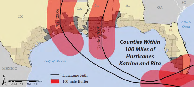 Gulf of Mexico coastal counties within a 100-mile buffer of the tracks of Hurricanes Katrina and Rita (2005). Credit: Coastal Services Center, NOAA, 2008. Gulf of Mexico coastal counties within a 100-mile buffer of the tracks of Hurricanes Katrina and Rita (2005). Credit: Coastal Services Center, NOAA, 2008.
|
Both Hurricanes Katrina and Rita had a tremendous effect on the Gulf Coast Region’s population in 2005. A total of 60 Gulf coastal counties were within 100 miles of both hurricane paths. Although a significant number of residents left St. Bernard Parish, LA, following Hurricane Katrina, the parish is projected to experience a high level of return in the coming decade: the highest percent increase in population is expected to occur in St. Bernard Parish, growing by 89% by 2015.
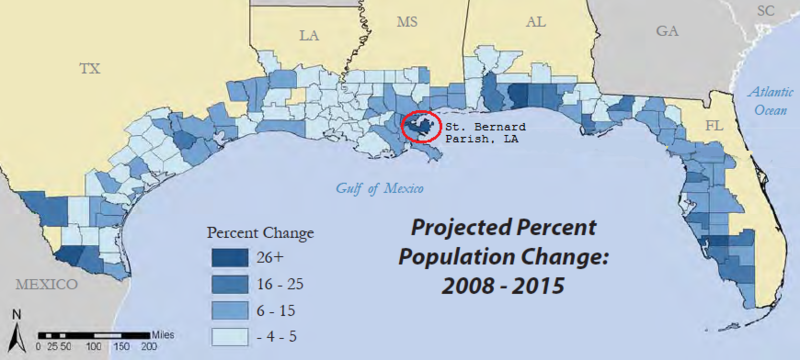 Expected percent population change from 2008 to 2015 in the Gulf Coast Region. Credit: Woods and Poole Economics, Inc., 2007. Expected percent population change from 2008 to 2015 in the Gulf Coast Region. Credit: Woods and Poole Economics, Inc., 2007.
|
Housing and Development
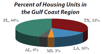 Percent of Gulf Coast Region housing units by state. Credit: U.S.Census Bureau, 2007 Percent of Gulf Coast Region housing units by state. Credit: U.S.Census Bureau, 2007
|
Residential development in the Gulf Coast Region is increasing. Construction of housing units may act as an indicator of economic growth, “sprawl” along the coast, or the rebuilding of previous housing units lost. People nationwide are drawn to the Gulf Coast Region as a vacation destination; therefore, one component of this development is seasonal homes.
From 2002 to 2006, there was an 8% increase in the number of housing units in the Gulf Coast Region. Total number of housing units in the entire U.S. increased by 6%. Harris County, TX leads the Gulf Coast with the highest total number of housing units with 1,495,016, followed by Hillsborough County, FL (505,654) and Pinellas County, FL (498,415).
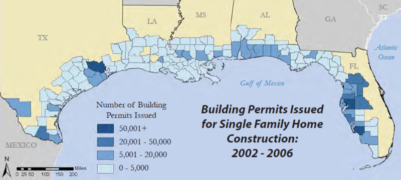 Building permits issued from 2002 to 2006 in the Gulf Coast Region. Credit: US Census Bureau Building permits issued from 2002 to 2006 in the Gulf Coast Region. Credit: US Census Bureau
|
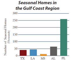 Seasonal housing units in the Gulf Coast Region by state. Credit: U.S. Census Bureau, 2000. Seasonal housing units in the Gulf Coast Region by state. Credit: U.S. Census Bureau, 2000.
|
827,000 Approximate number of building permits issued for new single family home construction from 2002 to 2006 in the Gulf Coast Region. 26% of the entire nation’s coastal county building permits were issued in the Gulf Coast Region (single family units only). Three of the ten leading counties in building permits issued nationally were located in the Gulf Coast Region: Harris County, TX, Lee County, FL, and Hillsborough County, FL. Harris County, Texas, led the nation in building permits issued from 2002 to 2006 with a total of 143,000.
5% of all housing units in the Gulf Coast Region are seasonal. Kenedy County, TX leads the Gulf Coast with the highest percentage of seasonal homes at 37%, followed by Walton County, FL and Cameron County, LA, both with 27%.
In addition to the population changes the Gulf Coast Region experienced as a result of Hurricanes Katrina and Rita, housing was also considerably altered. Housing units declined in the year following Hurricane Katrina in counties within 100miles of the hurricane’s track.
 Single family housing unit change in the Gulf Coast Region from 2004 to 2006. Credit: US Census Bureau; NOAA Single family housing unit change in the Gulf Coast Region from 2004 to 2006. Credit: US Census Bureau; NOAA
|
Source: US Census Bureau; NOAA.
Coastal Vulnerability
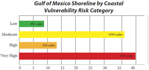 Percentage of mapped shoreline along the U.S. Gulf of Mexico coast in each risk category based on the C.V.I. (including length of shoreline in each category). Credit: Thieler and Hammer-Klose, 2006. Percentage of mapped shoreline along the U.S. Gulf of Mexico coast in each risk category based on the C.V.I. (including length of shoreline in each category). Credit: Thieler and Hammer-Klose, 2006.
|
Predicted sea-level rise may cause physical changes to the coast, which could adversely impact communities and infrastructure located along the Gulf of Mexico. Being aware of the relative vulnerability of coastal areas to sea-level rise-related erosion, flooding, and storm damage will help communities to consider the longer-term costs of protecting or relocating themselves.
It is certain that Gulf coastal communities will continue to experience significant, destructive coastal storms. By transforming into “resilient” communities, they increase their ability to “bounce back” after hurricanes and flooding. Resilient communities, with the ability to quickly recover both economically and socially, will be critical to the region’s long-term viability and success in the face of predicted sea-level rise.
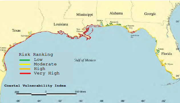 Coastal vulnerability in the Gulf of Mexico region (based on the Coastal Vulnerability Index5 (C.V.I.)). The C.V.I. shows the relative vulnerability of the coast to physical changes due to predicted rise in sea level. Credit: Thieler and Hammer-Klose, 2006. Coastal vulnerability in the Gulf of Mexico region (based on the Coastal Vulnerability Index5 (C.V.I.)). The C.V.I. shows the relative vulnerability of the coast to physical changes due to predicted rise in sea level. Credit: Thieler and Hammer-Klose, 2006.
|
Gulf Economy
The five U.S. states that border the Gulf of Mexico have a gross domestic product (GDP) of over $2.2 trillion (Bureau of Economic Analysis), and if a country, this would make the region the seventh largest economy in the world (International Monetary Fund). The robust economy of the Gulf of Mexico region provides jobs for more than 20 million people. Much of that economic activity is dependent on or related to the Gulf of Mexico and its natural resources. This section of the article presents four key economic activities in the GOM region. Tourism and recreation provide over 620,000 jobs; 27% of domestic crude oil production comes from the Gulf of Mexico region; the major commercial fishing ports of the region bring in over 1.2 billion pounds of fresh seafood every year; and six of the top 10 leading shipping ports in the country are found in the Gulf of Mexico region. These facts highlight the importance of the Gulf of Mexico region to the entire Nation and countries around the globe.
Recreational Fishing
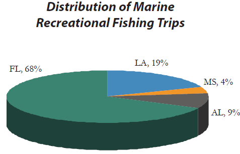 Percent of the 25 million Gulf of Mexico marine recreational fishing trips in 2006 by state. Credit: National Marine Fisheries Service, NOAA, 2007b. Note: The state of Texas does not participate in the Marine Recreational Fishery Statistical Survey. Percent of the 25 million Gulf of Mexico marine recreational fishing trips in 2006 by state. Credit: National Marine Fisheries Service, NOAA, 2007b. Note: The state of Texas does not participate in the Marine Recreational Fishery Statistical Survey.
|
From fly-fishing shallow-water flats for red drum to fishing along structures and reefs for groupers, the Gulf of Mexico offers a variety of diverse habitats and species for those seeking a recreational fishing adventure. Both residents and tourists are drawn to these inland and open-water opportunities. 3.6 million Gulf of Mexico region residents took part in marine recreational fishing in 2006.
The Gulf of Mexico accounted for over 40% of all U.S. marine recreational fishing catch in 2006 and 28% of total U.S. marine recreational fishing trips taken. 25 million marine recreational fishing trips were taken in the Gulf of Mexico during 2006.
193 million fish were caught in 2006 in the Gulf of Mexico, 56% of which was released. Spotted seatrout was the most caught recreational fishing species in the Gulf of Mexico in 2006, with 18 million pounds harvested. Other species with high harvest values include red drum (14.2 million pounds), sheepshead (4 million pounds), king mackerel (3.4 million pounds), and red snapper (3.2 million pounds) Harvest values do not include Texas.
Source: NOAA
Commercial Fishing
The commercial fishing industry in the GOM region has long supported the livelihood of its residents. This multi-billion dollar industry has traditionally included finfish, shrimp, oysters, and crab.
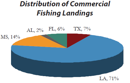 Distribution of the 1.3 billion pounds of commercial fishing landings by state. Credit: National Marine Fisheries Service, NOAA, 2007 Distribution of the 1.3 billion pounds of commercial fishing landings by state. Credit: National Marine Fisheries Service, NOAA, 2007
|
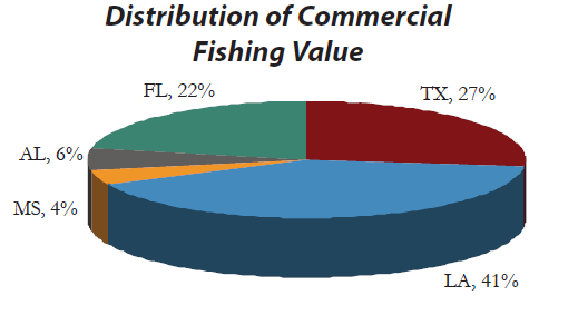 Distribution of the $662 million of commercial fishing value by state. Credit: National Marine Fisheries Service, NOAA, 2007 Distribution of the $662 million of commercial fishing value by state. Credit: National Marine Fisheries Service, NOAA, 2007
|
In 2006, three of the top six commercial fishing ports in the U.S. by landings were located in the GOM region. 83% of total U.S. shrimp landings were in the Gulf of Mexico region, a three-year average of 254 million pounds. 56% of total U.S. oyster landings occurred in the GOM region (a three-year average of 22 million pounds). 14% of total U.S. commercial fishery landings occurred in the Gulf of Mexico region (Alaska accounts for 57% of all landings). Commercial fishery landings in the Gulf of Mexico region account for an average of 1.3 billion pounds per year, yielding a value of $662 million.
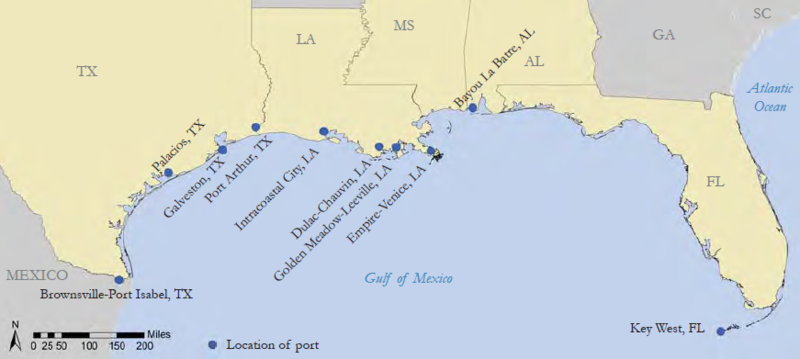 Locations of the ten most productive fishing ports in the Gulf of Mexico region (by value). Credit: National Marine Fisheries Service, NOAA, 2007 Locations of the ten most productive fishing ports in the Gulf of Mexico region (by value). Credit: National Marine Fisheries Service, NOAA, 2007
|
The top five species landings by poundage in the GOM region using a three-year average from 2004 to 2006 are menhaden (913.4 million pounds), brown shrimp (117.8 million pounds), white shrimp (114.6 million pounds), blue crab (58.9 million pounds), and eastern oyster (21.6 million pounds).
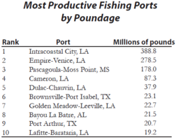 The ten most productive fishing ports in the Gulf of Mexico region by poundage, a three-year average from 2004 to 2006. Credit: National Marine Fisheries Service, NOAA, 2007 The ten most productive fishing ports in the Gulf of Mexico region by poundage, a three-year average from 2004 to 2006. Credit: National Marine Fisheries Service, NOAA, 2007
|
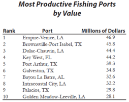 The ten most productive fishing ports in the Gulf of Mexico region by value, a three-year average from 2004 to 2006. Credit: National Marine Fisheries Service, NOAA, 2007 The ten most productive fishing ports in the Gulf of Mexico region by value, a three-year average from 2004 to 2006. Credit: National Marine Fisheries Service, NOAA, 2007
|
Source: NOAA
2005 Hurricane Season and Louisiana’s Fishing Industry
The 2005 hurricanes damaged and destroyed thousands of commercial vessels and the onshore infrastructure throughout coastal Louisiana, causing sharp declines in commercial landings and revenues. Thus, seafood landings shifted west to Texas and east to Alabama. The Louisiana Department of Wildlife and Fisheries’ 2005 preliminary estimates of losses to the state’s seafood industry as a result of Hurricane Katrina were $1.3 billion (annual total retail value), which represents about 40% of the industry’s annual total retail value (Wulfhorst, 2005).
Tourism and Recreation
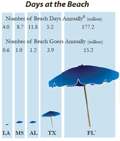 Beach visitation by state, 2000 (Florida numbers include the Atlantic Coast) Credit: National Ocean Service, NOAA, 2000. Beach visitation by state, 2000 (Florida numbers include the Atlantic Coast) Credit: National Ocean Service, NOAA, 2000.
|
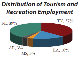 Distribution of 620,000 tourism and recreation jobs in the Gulf Coast Region by state. Credit: Bureau of Labor Statistics, 2006; Colgan, 2004. Distribution of 620,000 tourism and recreation jobs in the Gulf Coast Region by state. Credit: Bureau of Labor Statistics, 2006; Colgan, 2004.
|
 Total number of jobs and total wages for tourism and recreation jobs in the Gulf Coast Region. Credit: Bureau of Labor Statistics, 2006; Colgan, 2004. Total number of jobs and total wages for tourism and recreation jobs in the Gulf Coast Region. Credit: Bureau of Labor Statistics, 2006; Colgan, 2004.
|
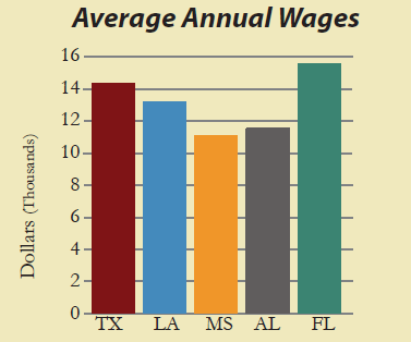 Average annual wages for tourism and recreation-related jobs in the Gulf Coast Region (data not normalized for length of season). Credit: Bureau of Labor Statistics, 2006; Colgan, 2004. Average annual wages for tourism and recreation-related jobs in the Gulf Coast Region (data not normalized for length of season). Credit: Bureau of Labor Statistics, 2006; Colgan, 2004.
|
| Source: Bureau of Labor and Statistics; Colgan, 2004 |
Monroe County, FL leads the Gulf Coast in percent of employment generated by tourism and recreation with 29%, followed by Orleans County, LA (18%), Franklin County, FL (14%), Okaloosa County, FL (12%), and Refugio County, TX (11%).
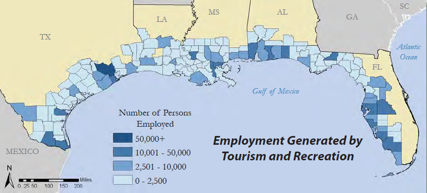 Employment generated by tourism and recreation in the Gulf Coast Region. Credit: Bureau of Labor Statistics, 2006; Colgan, 2004. Employment generated by tourism and recreation in the Gulf Coast Region. Credit: Bureau of Labor Statistics, 2006; Colgan, 2004.
|
 Percent of county employment generated by tourism and recreation in the Gulf Coast Region. Credit: Bureau of Labor Statistics, 2006; Colgan, 2004. Percent of county employment generated by tourism and recreation in the Gulf Coast Region. Credit: Bureau of Labor Statistics, 2006; Colgan, 2004.
|
The white sand beaches, excellent seafood restaurants, and warm weather found in the Gulf of Mexico region make it a popular destination for people from around the country and the world. Tourism and recreation have become very important to the economy of the region. There are over 620,000 jobs, yielding over $9 billion in tourism and recreation wages paid each year in the Gulf Coast Region. 8% of employment in the Gulf Coast Region is in the tourism and recreation fields. 87% of tourism and recreation jobs in the region are created by eating and drinking establishments.
Oil and Gas Production
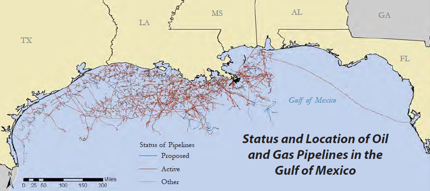 Oil and gas pipelines in the Gulf of Mexico. Credit: Minerals Management Service, 2008 Oil and gas pipelines in the Gulf of Mexico. Credit: Minerals Management Service, 2008
|
The GOM region’s oil and gas industry is one of the most developed in the world. Crude oil production in the GOM region accounts for 52% of the US total (based on a three-year average of crude oil production from 2005-2007). Natural gas production accounts for 54% (based on a three-year average of marketed production from 2004 to 2006) and crude oil refinery capacity 47% of the US totals (based on a three-year average of atmospheric crude oil distillation operable capacity from 2006 to 2008) EIA.
 Oil and gas platforms in the Gulf of Mexico. Credit: Minerals Management Service, 2008 Oil and gas platforms in the Gulf of Mexico. Credit: Minerals Management Service, 2008
|
There are approximately 4,019 oil and gas platforms in the Gulf of Mexico and 25,000 miles of active oil and gas pipelines on the seafloor. If placed end to end, these pipelines could wrap around the Earth’s equator (Source MMS).
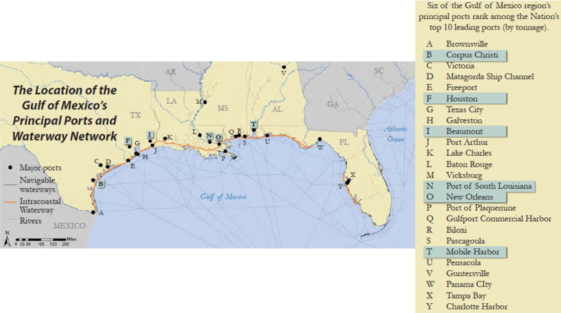 The location of the Gulf of Mexico’s principal ports and shipping lanes. Principal ports are determined by the amount of total commerce in short tons. Credit: USACE, 2007 The location of the Gulf of Mexico’s principal ports and shipping lanes. Principal ports are determined by the amount of total commerce in short tons. Credit: USACE, 2007
|
There are 107,210 reported petroleum-related workers employed in the Gulf Coast Region, earning over $12.7 billion in total wages (Source: Bureau of Labor and Statistics).
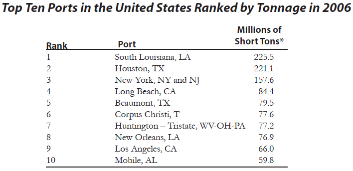 Leading U.S. ports in 2006 by tonnage. *Note: The short ton (S/T) is a unit of mass equal to 2,000 pounds (exactly 907.18474 kilograms). This is different than a metric ton, which is equal to 1,000 kilograms. Credit: USACE, 2007 Leading U.S. ports in 2006 by tonnage. *Note: The short ton (S/T) is a unit of mass equal to 2,000 pounds (exactly 907.18474 kilograms). This is different than a metric ton, which is equal to 1,000 kilograms. Credit: USACE, 2007
|
Waterborne Commerce
The U.S. economy relies heavily on the ports in the Gulf of Mexico region for the import and export of both foreign and domestic goods. The Gulf of Mexico region supports several ports that lead the Nation in total commerce. Six of the Nation’s 10 leading ports in 2006 for tonnage are located in this region. Texas and Louisiana led the nation in waterborne traffic in 2005.
The Port of South Louisiana stretches 54 miles along the Mississippi River. The port was ranked first in the U.S. in 2005 for total tonnage and is the largest tonnage port in the Western Hemisphere. In 2006, tonnage was up 6.2% from 2005, registering the single highest total in the history of the port with 225.5 million tons.
The Gulf Intracoastal Waterway extends 1,109 miles, greater than the distance from Washington, DC, to Miami, FL. The waterway is a dredged canal spanning from Florida to Texas, linking commerce along all five U.S. Gulf of Mexico states.
The U.S. Army Corps of Engineers dredged 49.5 million cubic yards in 30,000 square miles of south central and coastal Louisiana for 2005. The amount dredged could fill every football field in the state of Mississippi - more than 280 high school, college, and municipal stadiums - 100 yards long, 50 yards wide, and approximately 10 stories high.
Source: USACE
Gulf Ecology
The Gulf of Mexico is the ninth largest water body in the world and teems with sea life, from shrimp to unexplored deep-water corals living thousands of feet below the surface. The Gulf ’s size and unique ecologic diversity has led to the establishment of many state and national parks and habitat and wildlife preservation areas. Its coastal areas contain half the wetlands in the United States and are home to vital natural resources, including nesting waterfowl, colonial waterbird rookeries, sea turtles, and fisheries. These resources are supported by the abundant bays, estuaries, tidal flats, barrier islands, hard and soft wood forests, and mangrove forests. Biological diversity is not bound by political boundaries and to illustrate its distinct landscapes and habitats, the Gulf of Mexico region is presented as “ecoregions” in this article. Ecoregions are large areas with similar ecosystems, reflecting patterns of biotic and abiotic factors such as geology, landforms, hydrology, soils, climate, vegetation, land use, and wildlife. The Gulf of Mexico region’s ecological communities are essential to sustaining local economies, recreational experiences, and overall quality of life. However, these communities are susceptible to human and natural impacts.
Diversity
The Gulf of Mexico is home to diverse habitats, many unique to the Nation and the world.
Barrier Islands
Barrier islands are formations of sand, shell, and gravel that exist along coasts. These islands form a defense against winds and waves and provide habitat for many species of animals. Padre Island, TX, is 130 miles long and is the world’s longest barrier island. Kemp’s Ridley turtle, which has long been considered the most endangered sea turtle in the world, is known to nest there.
Hypersaline Lagoons
Hypersaline lagoons are characterized by little to no inland water flow and high rates of evaporation. Combined with the Laguna Madre of Tamaulipas, Mexico, Laguna Madre in Texas is the largest hypersaline system in the world. This area is home to the only strain of high-salinity adapted oysters in North America. Additionally, nearly 80% of all seagrass beds in Texas are found in the Laguna Madre.
Coral Reefs
The Flower Garden Banks National Marine Sanctuary encompasses a variety of habitat types, including the northern-most coral reefs in the continental United States. Located about 110 miles directly south of the Texas/Louisiana border, more than 300 acres of protected high-relief reefs are home to more than 23 species of coral, 250 reef invertebrates, 175 fishes, and 80 algae species.
Wetlands and Marshes
The wetlands and marshes in southern Louisiana act as a buffer to help moderate flooding and inundation during storm events. Erosion of the Mississippi delta, land subsidence, and rising sea levels threaten these wetlands. Louisiana’s coast, which contains 40% of the Nation’s wetlands, is disappearing into the Gulf of Mexico at a rate of 35 square miles a year, or the equivalent of a football field every 20 minutes.
Cyprus-Tupelo Swamps
In southern swamps, the two dominant trees are bald cypress and water tupelo and these areas are often referred to as cypress-tupelo swamps. Cypress-tupelo swamps are flooded year round, and only dry out during the most severe droughts. In the Atchafalaya National Wildlife Refuge, LA, these swamps provide vital nesting habitat for wood ducks, and support the Nation’s largest concentration of American woodcock.
White Sand Beaches
The Gulf Islands National Seashore (the Nation’s largest) is comprised of both Florida and Mississippi beaches. The stunning white sand found on these beaches is composed of fine quartz eroded from granite in the Appalachian Mountains. The sand is carried to the Gulf by rivers and creeks and deposited along the beach by currents.
Deep Coral Reefs
At more than 60 miles in length and60 to 80 meters deep, Pulley Ridge is a series of drowned barrier islands on the southwest Florida Shelf. Unusual at this depth, the southern portion of the ridge is home to a variety of corals; green, red, and brown macroalgae; and shallow-water tropical fishes. From the scientific perspective, southern Pulley Ridge may be the deepest coral reef in the United States.
Oyster Reefs
Today in Alabama, oysters are harvested by the traditional method of tonging. This is carried out from small boats by using tongs (rakes on the ends of long wooden poles) to gather and hold the oysters until they are lifted on board. Much of the oyster tonging in Alabama is conducted on public oyster reefs, but increasing numbers of oysters are cultured in waters adjacent to privately owned land.
Sponge Beds
During the early part of this century, the sponge fishery was very important to Florida’s economy. Of the five sponge species harvested commercially in Florida, sheepswool is the most important because of its durability and softness. Commercial sponges are found in both the Florida Keys and the northern Gulf, with approximately 60,000 - 70,000 pounds of sponges harvested annually.
Mangrove Forests
Red mangrove, black mangrove, and white mangrove are the three species of mangrove trees that grow in Florida, particularly in the Florida Keys. Mangroves grow in saltwater and in areas frequently flooded by saltwater. These trees provide protected habitat, breeding grounds, and nursery areas for many land and marine animals. Mangroves can also provide vital shoreline protection from wind, waves, and erosion.
Ecoregions and Threats
The Gulf of Mexico region is a rich mosaic of natural landscapes, agriculture, and an assortment of towns and cities. The region’s diversity provides abundant opportunities for uses like conservation, recreation, and commerce. Yet, at times, that very mix creates challenges in balancing these competing uses.
Gulf of Mexico Large Marine Ecosystem
Main Article: Gulf of Mexico Large Marine Ecosystem
The Gulf of Mexico is partially isolated from the Atlantic Ocean. Ocean waters enter from the Yucatan Channel and exit from the Straits of Florida, creating the Gulf ’s loop current. Freshwater sources to the Gulf are from rivers, especially the Mississippi River, and ground water from both the United States and Mexico. The region’s biologic productivity allows for a high level of biodiversity, including numerous species of fish, sea birds, and marine mammals.
This region includes:
- Important marine species such as bluefin tuna, groupers, oysters, snappers, shrimp, blue crab, and sea turtles
- Coral reefs
- Large portion of the Nation’s coastal wetlands
Threats to this region:
- Habitat loss, hypoxia, fisheries declines, harmful algal blooms, climate change, marine debris, chemical pollution, invasive species, sea level rise
Source: NOAA
Southern Texas Plains
Main Article: Ecoregions of Texas (EPA)
This region of thornscrub and sparse grassland is locally known as the brush country. It comprises rolling plains and has a more distinct diversity of plant and animal life.
This region includes:
- Mesquite-grass
- Woody plants
- Cacti and other succulents
- Birds such as Altimira oriole and elf owl
- Rare animals such as the ocelot
Threats to this region:
- Overgrazing and conversion to agriculture
- Loss of native vegetation through controlled burns to make way for crops
- Dam construction
Source: Griffith et al., 2004; World Wildlife Fund
Western Gulf Coast Plains
Main Article: Western Gulf coastal grasslands
This region is distinguished by flat topography, grassland expanses, and a mild, subtropical climate. The coastal portion is comprised of barrier islands, bays, estuaries, and tidal marshes, and the inland plains contain sparse remnant forest and savanna and cropland.
This region includes:
- Many animal species, of which over 200 are in need of protection
- Endangered Kemp’s Ridley sea turtle nests at one beach in the region
Threats to this region:
- Urbanization and industrialization
- Fragmentation of remaining habitat
- Oil and gas production
Source: Griffith et al., 2004; World Wildlife Fund
Mississippi Alluvial Plain
Main Article: Ecoregions of the Mississippi Alluvial Plain (EPA)
This region is a flat alluvial plain broken up by river terraces, swales, and natural levees and undergoes regular flooding. The region essentially hugs the Mississippi River from the Gulf to the southern tip of Illinois.
This region includes:
- Vital leg of a migratory bird flyway
- Threatened species such as the Swainson’s Warbler and Louisiana black bear
Threats to this region:
- Hydrologic alterations to the region’s streams and rivers
- Heavy fertilizer, insecticide, and herbicide use
- Logging of small remaining bottomland forest
Source: Daigle et al., 2006; World Wildlife Fund, 2001
Mississippi Valley Loess Plains
Main Article: Ecoregions of Mississippi (EPA)
This region is characterized by its thick loess deposits (wind deposited silt). Its landscape includes irregular plains, gently rolling hills, and bluffs near the Mississippi River.
This region includes:
- Agriculture in the north
- Forest and cropland mosaic in the south
- Oak-hickory and southern mesophytic forests
Threats to this region:
- Hydrologic alterations to the region’s streams and rivers
- Heavy fertilizer, insecticide, and herbicide use
Source: Chapman et al., 2004; World Wildlife Fund
Southeastern Plains
This region is comprised of irregular plains that are a diverse mix of cropland, pasture, woodland, and forest. Urban uses are expanding and in some areas, much of the land has been converted to agriculture.
This region includes:
- Native oak, hickory, pine, and Southern mixed forest
- Diversity of snail species, amphibians, reptiles, birds, butterflies, and mammals species
Threats to this region:
- Agricultural and urban development
- Logging and forest conversion to commercially viable pine
- Lack of fire management for appropriate fire regimes
Source: Griffith et al., 1994; NatureServe Explorer, 2007
Southern Coastal Plains
The coastal area of this region is distinguished by barrier islands, estuaries, and lagoons. Further inland there is flat topography with numerous forested wetlands and lakes. The region’s land cover is pasture, urban development, and longleaf-slash pine forest, with hardwood forests in low-lying areas.
This region includes:
- Important species such as the Flatwoods Salamander and the endangered Pondberry (a rarely seen plant)
Threats to this region:
- Land conversion
- Runoff from agriculture and urban expansion
Source: Griffith et al., 1994; NatureServe Explorer, 2007
Southern Florida Coastal Plains
Main Article: Ecoregions of Florida (EPA)
A unique characteristic of this region is its frost-free climate, making it unique in the continental United States. This region is characterized by flat plains with wetlands where the vegetation is primarily everglade and palmetto prairie.
This region includes:
- Everglades and palmetto prairie vegetation
- Several parks, game refuges, and Indian reservations
Threats to this region:
- Hydrological and biological alterations
- Urban and agricultural expansion
Source: Griffith et al., 1994
Hypoxia in the Gulf of Mexico
There are numerous threats to the Gulf of Mexico marine ecosystem, including the world’s second largest human-caused zone of hypoxia. This hypoxic area, commonly referred to as the “Dead Zone,” illustrates the enormity and complexity of the threats facing the region’s ecology and economy.
 The Mississippi River watershed and location of the hypoxic zone in the Gulf of Mexico. Credit: U.S. Geological Survey, 2004. The Mississippi River watershed and location of the hypoxic zone in the Gulf of Mexico. Credit: U.S. Geological Survey, 2004.
|
What is Hypoxia?
Hypoxia refers to depleted concentrations of dissolved oxygen in the water column, so depleted that fish and shellfish might not have enough oxygen to survive. Hypoxia can occur naturally; however, it often indicates a human-caused oversupply of nutrients – specifically nitrogen and phosphorus – from both urban and agricultural sources. This oversupply of nutrients in the water, a state called eutrophication, can cause intensive growth of plants and phytoplankton, or single-celled algae. When this bloom of plants and phytoplankton dies, they sink to the ocean bottom and decompose, a process that consumes dissolved oxygen.
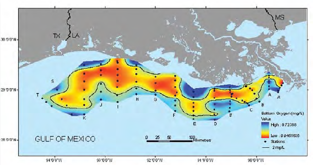 bottom:water dissolved oxygen concentrations for July 21-28, 2007. Credit: NOAA/A. Sapp, Louisiana Universities Marine Consortium. bottom:water dissolved oxygen concentrations for July 21-28, 2007. Credit: NOAA/A. Sapp, Louisiana Universities Marine Consortium.
|
Gulf Hypoxia and the Mississippi Valley Watershed
The Mississippi River begins below Lake Itasca in northern Minnesota, and flows approximately 2,350 miles to the Gulf of Mexico. On this journey, the Mississippi River captures runoff from 41% of the continental United States, making it the largest watershed in North America. Human activities have greatly altered the Mississippi River and its watershed; as a result, the river delivers substantial amounts of sediment, nutrients, and chemical pollutants to the Gulf of Mexico.
Since the 1970s, scientists have documented a large area of hypoxia off the coast of Louisiana and Texas. This “Dead Zone” forms annually in late spring, reaching its greatest extent in midsummer, and ebbing in the fall. Since 1985, it has fluctuated between 15 and 8,500 square miles in size, forming in the middle of a nationally important commercial and recreational fishing area.
See also
- Seas of the World. Encyclopedia of Earth.
References
- Chapman, S.S., G.E. Griffith, J.M. Omernik, J.A. Comstock, M.C. Beiser, and D. Johnson. 2004. Ecoregions of Mississippi. U.S. Geological Survey, Reston, VA.
- Colgan, Charles S. November 2004. Employment and wages for the U.S. ocean and coastal economy. Monthly Labor Review. Vol. 127, No. 11.
- Daigle, J.J., G.E. Griffith, J.M. Omernik, P.L. Faulkner, R.P. McCulloh, L.R. Handley, L.M. Smith, and S.S. Chapman. 2006. Ecoregions of Louisiana. U.S. Geological Survey, Reston, VA. Available from: http://www.epa. gov/wed/pages/ecoregions/la_eco.htm.
- Griffith, G.E., J.M. Omernik, C.M. Rohm, and S.M. Person. 1994. Florida regionalization project. EPA/600/Q-95/002. U.S. EPA, Environmental Research Laboratory, Corvallis, OR. 83p. Available from: http://www.epa.gov/wed/pages/ ecoregions/fl_eco.htm.
- Griffith, G.E., J.M. Omernik, J.A. Comstock, S. Lawrence, G. Martin, A. Goddard, V.J. Hulcher, and T. Foster. 2001. Ecoregions of Alabama and Georgia. U.S. Geological Survey, Reston, VA.
- Griffith, G.E., S.A. Bryce, J.M. Omernik, J.A. Comstock, A.C. Rogers, B. Harrison, S.L. Hatch, and D. Bezanson. 2004. Ecoregions of Texas. U.S. Geological Survey, Reston, VA. Available from: http://www.epa.gov/wed/pages/ecoregions/tx_eco. htm.
- NatureServe Explorer. 2007. Ecological System Comprehensive Report: Southern Coastal Plain Nonriverine Cypress Dome. Available from: http://www. natureserve.org/explorer/servlet/NatureServe?searchSystemUid=ELEMENT_ GLOBAL.2.723234.
- Nipper M., J.A. Sánchez Chávez, and J.W. Tunnell, Jr., Editors. 2008. GulfBase: Resource Database for Gulf of Mexico Research. World Wide Web electronic publication. Available from: http://www.gulfbase.org.
- Rausch, D.A, and B. Schlepp. 1994. Native American Voices. 180 pages
- Thieler, R. E. and E. S. Hammar-Klose. 2006. National Assessment of Coastal Vulnerability to Sea-level Rise: Preliminary Results for the U.S. Gulf of Mexico Coast. U.S. Geological Survey Open-File Report 00-179. Available from: http://pubs.usgs.gov/of/2000/of00-179/.
- Woods and Poole Economics, Inc. 2007. Complete Economic and Demographic Data Source (CEDDS). Washington, DC.
Editor's Note: This article contains excerpts from NOAA's "The Gulf of Mexico at a Glance.' It has been substantially modifed and expanded by the EoE contributing authors.