Great Basin montane forests
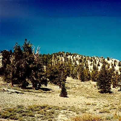
Great Basin National Park, Nevada, USA. (Photograph by John Morrison)
 WWF Their are few perennial streams in low-lying areas in this dry ecoregion. Annual precipitation in the basin ranges from 130-490 millimeters (mm) with most precipitation falling in the [[mountain]s] as snow. At higher elevations, forest soils are present and include entisols (mesic-cryic) and aridisols (xeric). Vegetation from valley bottoms to mountain tops includes shrub-steppe, woodlands, pinyon pine (Pinus spp), juniper (Juniperus spp.), Douglas-fir (Pseudotsuga menziesii), and subalpine communities. Woodlands represent a transition between moister coniferous forests of higher elevations and drier grasslands and deserts of the basin. They tend to be more open than forests and contain smaller trees. The dominant woodland trees are drought-tolerant pines and junipers derived from Mexican sources, while conifers are mainly cold-tolerants derived from boreal regions. Four major woodland and forest types have been identified in this region, including montane white fir (Abies concolor) forest, subalpine woodland, limber pine (P. flexilis) woodland, and Great Basin bristlecone pine (P. longaeva) woodland. Great Basin bristlecone is a true timberline species of highest (up to 3,540 meters (m)) desert elevations. The species typically forms pure open stands, otherwise it mixes with limber pine and is found on the poorest and driest soils and grows in some of the harshest climates within the region (e.g., mountain tops). Bristlecones are among the oldest living organisms on earth with some individuals dated at more than 4,600 years. Ironically, this ancient individual was cut down in the dating process. Subalpine woodlands are among the highest elevation woodlands in the region and consist of white pines (P. flexilis or P. longaeva). These trees are usually too short and widely spaced to be considered forests.
Montane white fir forests are widely scattered open groves that often mix with pinyon and other trees in steep mesic, north-facing ravines and slopes below the crests of [[mountain]s]. Limber pine woodlands are desert-oriented white pines that rarely form forests and are usually mixed with bristlecone. Limber pine and white fir mix in groves at the heads of east-facing canyons where white bark pine (P. albicaulis) and mountain hemlock (Tsuga mertensiana) occur along west-facing canyons. In the White Mountains, limber pine is most abundant on moist, granitic soils at 2,900-3,355 m and at lower elevations this species forms pure stands. Other less prominent woodland types include lodgepole pine (P. contorta) and aspen (Populus tremuloides). Lodgepole pine is distributed sporadically within some north-facing canyons, and aspen groves occur on moist slopes and meadows on east slopes. Fire is the chief disturbance throughout the region.
Biological Distinctiveness
The biogeography of the forested mountaintops of the Great Basin has often been compared to that of an archipelago of oceanic islands. This "continental" island system has allowed biologists to explore many interesting ecological and evolutionary questions, such as the rate of differentiation among isolated taxa. The cool coniferous forests occur on widely separated mountaintops in a sea of Great Basin shrub and desert habitats, resulting in pronounced isolation for many forest species on individual ranges or peaks. Thus, several species and subspecies of plants, invertebrates, and some vertebrates occur only on one or a few peaks. The mosaic of forest and woodland types occurring along elevation gradients in this region results in high local beta diversity. However, when compared with other temperate coniferous forests within its major habitat type, the region contains intermediate levels of biodiversity (total richness = 395, total endemism = 9). Birds comprise the greatest (40%) number of species of the various taxa evaluated, followed by butterflies (31%), and mammals (14%). Although not evaluated in this assessment, the region is estimated to contain up to 26,000 species of insects. The numerous mountain ranges and riparian areas in the basin act as important refugia and corridors for geographic expansion of species currently found more commonly in more north regions.
Conservation Status
Habitat Loss
Habitat loss in this region has been moderate with 25-50 percent of the remaining area still intact. However, fire suppression and livestock grazing have resulted in shifts in species composition particularly in lowland areas where invasive species such as Russian thistle (Salsola australis), cheatgrass (Bromus tectorum), and exotic wheatgrass (Agropyron spp.) have prospered.
Remaining Blocks of Intact Habitat
Few large (greater than 250 square-kilometer (km2)) areas are present in this ecoregion. This is, in part, an artifact of the ecoregion delineation; most of the ecoregion is defined by relatively small ecological units.
Habitat Fragmentation
Workshop participants did not recognize habitat fragmentation as a significant factor affecting biodiversity in this region. Again, this was an artifact of the delineation and most of the area is naturally isolated because of it is confinement to isolated mountain ranges.
Degree of Protection
Most protected lands and wilderness areas are managed by the USDA Forest Service and Great Basin National Park. Many of the larger ranges are part of National Forest Service lands, especially the Humboldt and Toiyabe National Forests.
Types and Severity of Threats
The major types of conversion threats in this region are: (1) livestock grazing, (2) gold mining, and (3) microwave communication sites.
Suite of Priority Activities to Enhance Biodiversity Conservation
The highest priority activities in this ecoregion include restoring native communities impacted by livestock grazing and invasive species.
Conservation Partners
- Nevada Association of Conservation Districts
- Nevada Wildlife Federation
- Wildlife Society Nevada Chapter
Relationship to Other Classification Schemes
This ecoregion corresponds to the montane regions of Omernik's ecoregion #13 and Bailey's ecoregion #341A. Because beta diversity created drastically different communities between montane forests and basin types, we split the montane portion of the Great Basin into its own ecoregion and treated the Great Basin shrub steppe separately.
Additional Information on this Ecoregion
- For a shorter summary of this entry, see the WWF WildWorld profile of this ecoregion.
- To see the species that live in this ecoregion, including images and threat levels, see the WWF Wildfinder description of this ecoregion.
- World Wildlife Fund Homepage
| Disclaimer: This article is taken wholly from, or contains information that was originally published by, the World Wildlife Fund. Topic editors and authors for the Encyclopedia of Earth may have edited its content or added new information. The use of information from the World Wildlife Fund should not be construed as support for or endorsement by that organization for any new information added by EoE personnel, or for any editing of the original content. |