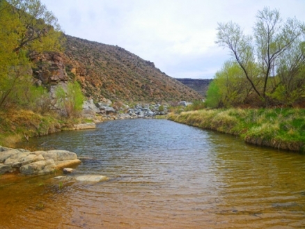
Gila River
The Gila River is a watercourse lying generally within Arizona and New Mexico in the USA, with a small portion of the tributary catchment situated in the Mexican state of Sonora. The Gila Basin consists chiefly of an arid landscape comprised to a considerable extent by elements of the Sonoran Desert. The mouth of the Gila River is characterized by discharge to the Colorado River.
Until around sixty million years ago, the Gila Basin was a vast swamp, with a torpid meandering flow. Gradual uplift of the Rocky Mountain block raised headwaters to their present elevation of about 3000 meters. Native American use of the basin includes considerable prehistoric deforestation, coupled with circa 1700-1850 AD Apache grassland burning; however, the most recent 150 years marks a notable afforestation, particularly in the upper elevations of the watershed.
Contents
Hydrology
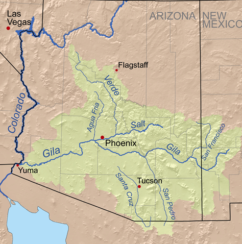 Gila River Basin in the southwestern USA. Source: K.Musser The entire [catchment] of the Gila River encompasses an area of approximately 150,740 square kilometers.The river rises in Sierra County in western New Mexico on the western slopes of the Continental Divide in the mountains known as the Black Range.
The principal tributaries of the Gila River are: San Simon River, San Pedro River, Santa Cruz River, San Francisco River, Salt River, Agua Fria River and the Hassayampa River.
Human interference in ecosystems
Although humans have existed in the basin for the entire Holocene, their earliest role in ecosystem modification was likely during the first millenium AD, when timber harvesting by Mogollon, Hohokam and even Anasazi peoples. Thus there is evidence that an earlier forest rich cover became more grasslanddominant at least as early as about 700 AD. However, disturbance of the natural fire regime coupled with overgrazing has led to a reversal of events in the last 150 years. Thus presently, there is a marked increase in afforestation, both a high altitudes with pines, oaks and fir, and at lower elevations with mesquite growth. In fact, this recent trend in afforestation is likely the greatest percentage positive change in forest cover anywhere in North America over the modern period.
Water quality
Sedimentation has been a prominent issue in historic times, likely due to the loss of grass cover which systematically occurred over the period 500 to 1850 AD, due to ancient deforestation by Native Americans and later grassland burning by Apache peoples followed by overgrazing caused by European settlers. The basin is inherently vulnerable to sedimentation due to the erosive soil cover over most of the catchment. In parts of the Gila River system there are elevated levels of certain heavy metals, especially lead and selenium. Nitrate levels are generally not of concern, because of the low human and grazing animal population densities and low intensity agricultural use within the basin; however, there are localized issues of elevated nitrate in irrigation return waters from agricultural uses. Fluoride levels in parts of the river system are elevated creating a circumstance of low health risk, but a precursor of teeth discoloration.
Aquatic biota
Native fishes in the Gila River system include the threatened demersal spikedace (Meda fulgida); this species is endemic to the upper Gila River Basin generally at elevations of 1800 to 2000 meters. This taxon is slender in form with a pointed snout and total body length of about eight centimeters. Coloration is olive-grey to brown above, with silvery sides that frequently exhibit blue flashes, accompanied with black speckling on the back and upper side. Breeding males manifest a bright, brassy yellow head and fins. Preferred spikedace habitat consists of moderately flowing streams with sand or gravel bottom; the species is threatened by stream channelization and adverse water qualtiy impacts.
The razorback sucker (Xyrauchen texanus) is an endangered species of fish with limited distribution in the Western USA, including upper reaches of the Gila Basin. Key extant metapopulations of this taxon are found in the Gila River, Green River (Utah), Yampa River and Lake Mohave in Arizona.
The sonora tiger salamander (Ambystoma tigrinum stebbinsi) is an endangered amphibian found in the Gila River Basin. The range of this near-endemic is delimited by Sonora north to the Canelo Hills and lying between the crests of the Huachuca and Patagonia Mountains. This salamander is resilient to wide swings in thermal stress, and thus not threatened by any trends in temperature change. Much of the breeding habitat of this taxon consists of man-made cattle ponds, and a prime driver of extinction is the presence of the barred tiger salamander (A.mavortium mavortium), which can interbreed with and genetically pollute A. tigrinum stebbinsi, which has much smaller numbers. The two salamanders are so close in appearance that genetic testing is required for exact speciation.
Another amphibian occurring in the Gila Basin is the threatened Chiricahua leopard frog (Lithobates chiricahuensis), which is found only at higher elevations (e.g. above 1000 meters) in reservoirs, small pools and cattle ponds. Threats to the species include poorly managed cattle operations, over-use of pesticides and herbicides, runoff from copper mining and presence of a pathogenic chytridiomycete fungus.
Terrestrial ecoregions
Several terrestrial ecoregions encompass the Gila drainage basin: 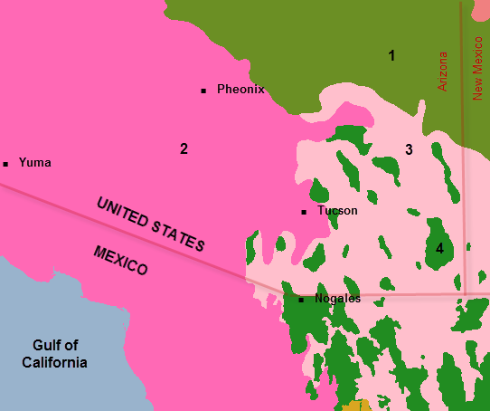 Ecoregions comprising the Gila Basin. Source: WWF
The Arizona mountains forests ecoregion is an exception to the aridity of the majority of lower elevation parts of the Gila watershed. The transition zone of this ecoregion comprises a strong Mexican fasciation, includes several dominant pine species including Chihuahua pine (Pinus leiophylla) and Apache pine (P. engelmannii) and unique varieties of ponderosa pine (P. ponderosa var. arizonica).The zone above 2000 meters (m) includes mostly Rocky Mountain species of mixed-conifer communities such as Douglas-fir (Pseudotsuga menzeisii), Engelmann spruce (Picea engelmanni), subalpine fir (Abies lasiocarpa), and white fir (corkbark variety, A. lasiocarpa var. arizonica). Dwarf juniper (Juniperus communis) is an understory shrubby closely associated with spruce/fir forests. Exposed sites include southwestern white pine (P. strobiformis, a variety of limber pine), while disturbed north-facing sites consists primarily of lodgepole pine (P. contorta) or Quaking aspen (Populus tremuloides).
Virgin forests in this region often exceed 25 meters in height and are commonly layered in two or more age classes. Below 2900 m one or more of the age classes may be composed solely of Quaking aspen, an important wildlife habitat component and pioneer species following fire. Wetter sites contain Rocky Mountain maple (Acer glabrum), Bebb willow (Salix bebbiana), scouler willow (S. scouleriana), blueberry elder (Sambucus glauca), thin-leafed alder (Alnus tenuifolis), or bitter cherry (Prunus emarginata). Dry windy sites may be occupied by limber pine (P. flexis) and Bristelcone pine (P. aristata). At lower elevations (less than 2600 m) Douglas-fir intermingles with ponderosa pine and white fir (A. concolor).
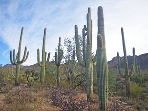 Saguaro National Forest, Pima County, AZ. @ C.Michael Hogan The Sonoran Desert comprises much of the desert floor and bajada lower elevations of the Gila Basin. The Sonoran Desert is bounded in the east and southeast in a transition to the temperate coniferous forests of the Arizona Mountains and Sierra Madre Occidental pine-oak forests at higher elevations. Finally, to the south the Sonoran-Sinaloan transition subtropical dry forest is the ecotone from the Sonoran Desert to the Sinaloan dry forests of Sinaloa.
In the Chihuahuan Desert, due to its recent origin, the few warm-blooded vertebrates are restricted to the Chihuahuan Desert scrub. However, the Chihuahuan desert supports a large number of wide-ranging mammals, such as the pronghorn antelope (Antilocapra americana), mule deer (Odocoileus hemionus), grey fox (Unocyon cineroargentinus), jaguar (Panthera onca), collared peccary or javelina (Pecari tajacu), desert cottontail (Sylvilagus auduboni), black tailed jackrabbit (Lepus californicus), kangaroo rat (Dipodomys sp.), pocket mouse (Perognathus spp.), woodrat (Neotoma spp.) and deer mice (Peromyscus spp.). With only 24 individuals recorded in the state of Chihuahua Antilocapra americana is one of the most endangered species that resides in this desert. The ecoregion also contains a small wild population of the highly endangered American bison (Bison bison) and scattered populations of the highly endangered Mexican prairie dog (Cynomys mexicanus), as well as the common prairie dog (Cynomys ludovicianus).
The Sierra Madre Oriental pine-oak forests contains a very diverse and unique community of endemic and specialized species of plants, animals, reptiles and amphibians. These high mountains run north to south, beginning in the United States and ending in Mexico. The variation accumulated in this distance, between its ends and elevation ranges, increases the diversity of [[habitat]s] and species present.
Prehistory
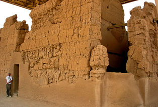 Hohokam ruins at Casa Grande from circa 1300 AD. Source: Dmitri Lytov Early Native Americans were present in the Gila Basin prior to the Holocene as hunter gatherers, although archaeological recovery of these earliest eras is scant.
Much of the early prehistory of the Gila Basin is associated with the Hohokam culture, whose pioneer period consists of small village settlements along the middle reaches of the Gila River; this era is generally considered to span the period 1 to 750 AD. These early settlements had a sedentary agriculture component, and extensive irrigation was conducted using diversions of the Gila River to grow maize, squash, beans and cotton.
There is no doubt that the Hohokam were influenced by their more advanced neighbors to the northeast, the Anasazi. Examination of their architectural styles and earlier peaking of Anasazi culture, especially at Chaco Canyon, indicates such a relationship.
Hohokam culture featured three discrete types of ceramics: plain ware, red ware and decorated varieties. MIneral content can be used to trace the locus of origin, with the chief distinctive ingredients being mica, quartz, quartzite, phyllite (also known as Squaw Peak schist), along with granite and arkosic sands. Thus, the subcultural region of Hohokam can be deduced from the distinctive mineral mix (e.g. Wingfield pottery associated with the Aqua Fria sub-basin; Salt pottery associated with the Salt River or Verde sub-basin).
Mogollon peoples inhabited some of the higher elevations of the catchment, constructing pithouses and often engaging in seasonal migrations. The Mogollon, however, substantially abandoned the watershed around 1400 AD.
References
- Michael J.Cohen, Christine Henges-Jeck and Gerardo Castillo-Moreno. 2001. A preliminary water balance for the Colorado River delta, 1992–1998. Journal of Arid Environments 2001 (49): 35–48.
- James P.Collins and Jonathan Snyder. 2002. Sonora tiger salamander recovery plan. U.S.Fish and Wildlife Service, Region 2
- Patrica L.Crown, and James W.Judge, editors. 1991. Chaco & Hohokam: Prehistoric Regional Systems in the American Southwest. School of American Research Press, Sante Fe, New Mexico. ISBN 0-933452-76-4.
- Suzanne K.Fish. 2000. Hohokam Impacts on Sonoran Desert Environment. in Imperfect Balance: Landscape Transformations in the Precolumbian Americas. ed by David L. Lentz. Columbia University Press, New York, pages 251-280
- James Galloway. 2002. Optimizing nitrogen management in food and energy production. books.google.com 1013 pages
- Paul C.Marsh. 1991. Spikedace recovery plan. U.S.Fish and Wildlife Service, Region 2
- Stephen Plog. 1997. Ancient Peoples of the American Southwest. Thames and Hudson, London, England. ISBN 0-500-27939-X
- Mike Sredl and Randy Jennings. 2007. Chiricahua leopard frog recovery plan. U.S.Fish and Wildlife Service Region 2
- Henry Smith Turner. 1966. The original journals of Henry Smith Turner with Stephen Watts Kearny to New Mexico and California, 1846-1847. Ed. Dwight L.Clarke. University of Oklahoma Press, Norman, Oklahoma
- Harold M.Tyus. 1998. Razorback sucker recovery plan. U.S.Fish and Wildlife Service, Region 6
