Geography of the Albertine Rift
| Topics: |
Geology (main)
|
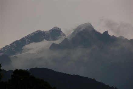
Mount Stanley in the Ruwenzori Range, Uganda. Source: Sylwia Duda
Geology, Mountains and Volcanoes
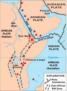 The Great Rift System in Africa, showing the eastern and western (Albertine Rift) branches and volcanoes as red triangles. Source: USGS
 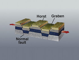 An idealized illustration of a rift valley. Source: USGS
 |
Zoomable map of the terrain of the Albertine Rift |
The Albertine rift is the result of cracking (or "rifting") in the earth's crust as the result of tension pulling apart the African continent. Whether this rifting with ultimately (on a geological time scale scale of millions of years) separate the eastern part of Africa from the rest is not known. However, geologists have gone so far as to give names to the would-be plates on either side of the rift. The Nubian Plate with most of the African continent lies the west of the rift, and the smaller Somalian Plate is moving east with the edge of the continent. The island of Madagascar is the result of something similar but smaller
The rifting in Africa is part of a larger rift that stretches from the Jordan Valley, through the Red Sea and south through the Afar Depression, Ethiopia and East Africa to Mozambique. This vast north-south rifting is known as the Great Rift System and is the largest rifting system on land in the world (the rifting that occurs under the world's oceans is far greater, but not directly observable).
The rifting that is occurring in Africa began approximately 40 million years ago and continues, reflected in (usually minor) earthquakes and volcanic activity in the region. The rifting that has occurred in East Africa is not simple; rather, it is the result of a large number of small rift events that have collectively resulted in the geological formations that are seen today.
South of Ethiopia the rift has two branches. The eastern branch, commonly known as the Great Rift Valley runs through Kenya and Tanzania. The western branch, commonly known as the Albertine rift runs through the border region of the Democratic Republic of the Congo with Uganda, Rwanda, Burundi, and Tanzania. Father south, the rift appears again around Lake Malawi. Within this general framework, there inconsiderable detail with numerous zones, faults, basins, and branches. There are features that are striking in how they illustrate the rift, and also areas so eroded that no signs of rifting are readily apparent. Between the two branches of the rift system is a plateau in which Lake Victoria, Africa's largest lake, sits in a shallow depression.
Research into the geological details and classification of the Albertine rift and ongoing and those provided here are subject to revision.
The text book illustration of a rift is one where a the split in the tectonic plate causes a valley or "basin" known as a graben to come into being. The valley is flanked by ridges known as "horsts."
The Albertine Rift is not quite so simple. First, reflecting the many faults that have created the overall rift valley, the western branch can be divided into up to 32 basins, each about 100 km long. Second, the western horsts are much higher than the eastern.
The Albertine rift is dominated by a series of mountain chains, originating on the Lendu Plateau in northern Uganda and the Democratic Republic of the Congo (DRC), and running south through the Ruwenzori mountains of Uganda and the eastern part of the Democratic Republic of Congo (03°N, 30°E), western Rwanda and Burundi, to some isolated massifs on the shores of Lake Tanganyika (to 08 °S).
The more mountainous western side of the Albertine rift begins in the north with the Lendu Plateau and Blue Mountains next to Lake Albert. The steep and rugged highlands continue south, bordering the lakes. There are two very notable mountainous areas slightly east of these highlands between Lake Albert and Lake Edward .
The Ruwenzoris are collectively a massif 120 km long and 50 km wide at the widest, separated from the highlands to the west by the Semliki river valley. There are twenty five peaks above 4,500 m high, including, Mounts Ngaliema (Mount Stanley), Speke and Baker, the third, fourth and fifth highest peaks in Africa. These are permanently covered by snowfields and small retreating glaciers; the lower Mounts Emin, Gessi and Luigi di Savoia also retain more or less permanent snowfields. Their high point is Africa's third highest peak, Pic Margherita (5,109 m), one of the two peaks of Mount Ngaliema.
This mass if is bisected by the border between the DRC and Uganda. The larger portion on the Ugandan side is included within Rwenzori Mountains National Park. The portion on the DRC side in included within the most extensive Virunga National Park.
Although not as high as Mount Kilimanjaro, and slightly lower than Mount Kenya, the Ruwenzoris have a larger alpine area than either and are the largest glaciated area in Africa. The existence of snow capped mountains just north of the equator was quite startling to Europeans in the nineteenth century and were quickly associated with the "Mountains of the Moon" reported by ancient geographers such as Ptolemy as the source of the Nile River. The Ruwenzori are indeed the highest and most permanent source of the river Nile, feeding it via eleven rivers flowing into [[Lake Edward] (Rutanzige)] and Lake George.
The Virunga Volcano Mountains region just south and east of the Ruwenzoris covers about 50 miles (80 km) runs east-west (perpendicular to the rift ) and includes eight major volcanoes, including two active ones which stem from the upwelling of volcanic material accompanying the the intense crustal movement creting the rift.
Nyamuragira (Nyamulagira) volcano (3,058 m) is located 25 km north of Lake Kivu and 30 km from the city of Goma. It is the most active volcano in Africa at this time, with significant eruptions roughly every two years. Lava flows from over the past century have covered much of the land near the volcano and extend to Lake Kivu
Nyiragongo volcano (3,470 m), just 15 km from Goma, has had 34 significant eruptions since 1882. On January 10, 1977, the side of the crater ruptured and very fluid lava killed some 2,000 people. A 2002 eruption destroyed part of Goma. Fortunately most of the 400,000 inhabitants had been evacuated and the death toll was just (though still tragically) forty-five.
Five volcanoes are grouped in Rwanda's Volcanoes National Park, Mounts Karisimbi (4,507 m), Visoke (Bisoke) (3,711 m); Muhavura (Muhabura) (4,127 m), Sabyinyo (3,505 m), and Gahinga (3,474 m). The eigth Virunga volcano, Mount Mikeno (4,437 m) lies just across the border in DRC's adjoining Virunga National Park. About half of the surviving 700 Mountain gorillas live in the area of these volcanoes.
Climate
The severe geological history has resulted in a diversity of climatic regimes. While the Rift is located in the center of tropical Africa the high mountain regions extensively modify the climate, with a more temperate climate occurring in the highlands. Average rainfall throughout the mountain range varies between 1,200 to 2,200 millimeters (mm) per annum, although it is locally more in some mountain areas.
Further Reading
- The Great Rift: Africa's Changing Valley by Anthony Smith, Sterling Publishing, 1989 ISBN: 0806969067
- The Physical Geography of Africa by William Adams, Andrew Goudie, and Antony Orme (Editors), Oxford University Press, USA, 1999 ISBN: 0198234066
- Tectonic development of the western branch of the East African rift system by C.J. Ebinger, GSA Bulletin; July 1989; v. 101; no. 7; p. 885-903
- East Africa's Great Rift Valley: A Complex Rift System] by James Wood and Alex Guth, Geology.com (accessed July 2, 2009)
- Volcanoes of Africa and the Red Sea, Global Volcanism Program, Department of Mineral Sciences, National Museum of Natural History, Smithsonian Institution (accessed July 2, 2009)