Garajonay National Park, Spain
Contents
- 1 Geographical Location
- 2 Date and History of Establishment
- 3 Area
- 4 Land Tenure
- 5 Altitude
- 6 Physical Features
- 7 Climate
- 8 Vegetation
- 9 Fauna
- 10 Cultural Heritage
- 11 Local Human Population
- 12 Visitors and Visitor Facilities
- 13 Scientific Research and Facilities
- 14 Conservation Value
- 15 Conservation Management
- 16 IUCN Management Category
- 17 Further Reading
Geographical Location
Garajonay National Park (28°05'-28°12'N, 17°10'-17°18'W) is a World Heritage Site in the central portion of La Gomera Island, Province of Santa Cruz de Tenerife. La Gomera (37,800 hectares (ha) in size), lies to the west of Tenerife, and is one of seven islands which make up the Canary Archipelago off the north-west coast of Africa in the Atlantic Ocean. The island is accessible by ferry from Tenerife. The park can be reached by road from the island's major towns and villages. 28°05'-28°12'N, 17°10'-17°18'W
Date and History of Establishment
The 1812 Constitution abolished the estates of the nobility and transferred ownership and administration of the forests to the municipal governments. In the same century, the forests were declared public property and appeared as such in the last Register of Public Property listing dated 1879. The national park comprises the following six public forests belonging to the six municipal districts of La Gomera: Agulo (770 ha), Alajero (250 ha), Hermigua (1,024 ha), San Sebastian (290 ha), Valle Gran Rey (350 ha), and Vallehermoso (1,300 ha). Gazetted a national park under Law 4/89 of 25 March 1981. Inscribed on the World Heritage List in 1986.
Area
3,984 ha.
Land Tenure
Municipal.
Altitude
750 meters (m) to 1,487 m.
Physical Features
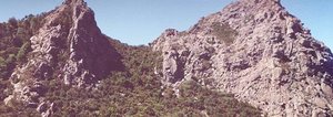
The park encompasses San Sebastian, Hermigua, Agulo, Vallehermoso, Valle Gran Rey and Alajero mountains. It consists of an eroded plateau and gently sloping central terrain whose steep sloping escarpments comprise uneven steps which extend as far as the park boundaries. La Gomera is the only island in the Canary's that has not experienced an eruption in recent times. Thus, ash and lava fields have been eroded away leaving mature soils formed from horizontal basalts cut by a series of ravines (known as barrancos). The local landscape is further characterized by volcanic dykes and domes (known as roques), examples of the latter being Agando, Ojila, La Zarcilla and Las Lajas found in the southeastern portion of the park. There are many springs and permanent streams on the island. The presence of the forest cover on La Gomera plateau causes mist vapor condensation, and helps maintain the island's main water sources.
Climate
Subtropical high pressures (Atmospheric pressure) from the North Atlantic are the predominant climatic feature. Trade winds from the north and north-east give rise to extensive cloud cover, typically at 600 m to 1,500 m altitude. Annual rainfall is between 600 millimeters (mm) and 800 mm. Relative humidity ranges from 75% to 90%, although occasional dry Saharian winds can drastically reduce it. Annual temperatures vary between 13°C and 15°C.
Vegetation
Principal vegetation types are influenced by altitude and geographical orientation, and lushness is maintained as a result of mist, condensed water vapor and the island's numerous streams and springs. The most important feature is the laurel forest which occupies about 70% of the park and is dominated by Laurisilva canaria. Other predominant and native species found within this forest type include laurel Laurus azorica, palo blanco Picconia excelsa, viñatigo Persea indica and til Ocotea foetens. The shrub layer comprises heath Erica arborea, bog myrtle Myrica faya, Arbutus canariensis, aceviño Ilex canariensis and I. perado, Erica scoparia, Heberdenia excelsa, Viburnum tinus, Visnea mocanera, Salix canariensis, Juniperus cedrus, Sambucus palmensis, Gesnouinia arborea, Rhamnus glandulosa and Maytenus canariensis.
The western boundary consists of an extensive heathland with bog myrtle, heather, mosses and lichens. Rockrose Cistus monspeliensis and Tabaiba spurge also occur here. Some 450 floral species have been recorded, of which 81 are endemic to the archipelago, 34 are endemic to the island, and eight are restricted to the national park. This type of subtropical vegetation resembles that found in the Tertiary period, but has largely disappeared from southern Europe due to climatic changes, and has been replaced by sclerophytic and xerophytic species. Its distribution is now limited to a few sites in Macaronesia, and even here is largely in an altered and highly reduced state.
Fauna
In keeping with island ecosystems, the fauna is impoverished, but with a high degree of endemism. Mammals and herpetofauna are poorly represented; only four native species of bat occur. Two species of bird, namely white-tailed laurel pigeon Columba junoniae (R) and dark-tailed laurel pigeon Columba bolli (R), are endemic to the Canaries and on La Gomera are largely restricted to the national park. In all, 27 bird species have been recorded. Almost 960 invertebrate species have been identified and of these, about 100 are endemic to the park.
Cultural Heritage
The island was colonized by the Spanish in the 15th century, and became an important intermediate port between Europe and America in the 16th century. A notable cultural heritage is the whistle language, developed by the local people to communicate over long distances.
Local Human Population
There are no settlements within the park, but approximately 16,000 people live on the island, and are dependent upon agriculture, fishing and tourist activities for their income. There are several settlements located at the park's boundary including El Cedro, Meriga, Epina, Las Hayas, El Cercado, and Igualero. Local people continue to use certain park areas that are traditionally associated with annual fiestasor pilgrimages. Other traditional uses, such as fuel collection and cattle raising have been reduced.
Visitors and Visitor Facilities
Approximately 450,000 visitors enter the park annually, and most only stay for the day. There is a visitor center at Juego de Bolos (just outside the park boundary) with an auditorium, eco-museum, botanical garden, and handcraft factory. A limited number of trails have been constructed restricting tourist access to the more sensitive areas.
Scientific Research and Facilities
A genetic rescue program for plants at risk of extinction was initiated in 1984, and was followed in 1991 by a plan to recuperate some of these species. A research program was recently prepared and proposes to carry out a thorough inventory in those areas that have experienced some degradation, as well as conclude flora, fauna, hydrology and climatic studies which are already underway. External research projects must first be approved by the park's Board of Trustees.
Conservation Value
The park harbors one of the largest continuous areas of laurisilva forest, a habitat that has almost disappeared from southern Europe and North Africa. Almost half of the remaining forest in the [[Canary] Islands] is included in the park. In spite of being biologically diverse, a large proportion of the flora (25%) and fauna (50%) are endemic, and many species are considered to be nationally threatened.
Conservation Management
Conservation matters are covered by several laws and decrees, namely: Law and Regulations on Protected Nature Sites; Law and Regulations on Forest; Law and Regulations on Land; Law 4/89 of nature protection, and several Royal Decrees. The park is within the administrative jurisdiction of Instituto para la Conservacion de la Naturaleza (ICONA), an independent body within the Ministry of Agriculture, Fisheries and Food. Administration is carried out by a management board comprising representatives from local government, universities and ecologists, their duties being circumscribed in law. Historically, several measures have been taken to preserve Garajonay's ecosystem: a ban on grazing (1942) and tree-felling (1964); prohibiting collection of dead leaves that protect soil; and protection of birds (Royal Decree No. 3181/1980).
Management objectives, as identified in the management plan, enacted by Decree 1531/1986 on 30 May 1986 by the Ministry of Agriculture, Fisheries and Food, include: restoration of degraded areas; conservation of genetic resources; eradication of introduced species, especially pine and eucalyptus; fire prevention; interpretation and education; and recreation provisions. The park has been zoned into a (biogenetic) reserve zone (covering 2,035 ha and is split into three sectors) with restricted access; a restricted use zone (858 ha), allowing limited traditional access and use; a (service) moderate use zone (89 1ha), where the environment has suffered some degradation and is used for recreation and education; and a special use zone (110 ha) which consists of small and scattered areas mainly on the periphery, and is used for visitor facilities. A new operative plan is available, detailing the specific objectives to be achieved during 1995.
Management Constraints
Following European colonization, the forest cover has seen dramatic changes. According to the entry in the Register of Public Property (1879) forest cover totaled 11,385 ha. Assuming these figures to be accurate, forest cover has been reduced by about 65% in just over 100 years.
Southern and western sections of the park have and continue to be threatened by deforestation, forest fires, and grazing. More than 500 ha of natural vegetation have been replaced by commercial plantations with exotic species such as Canary and Monterey pine. There are also small populations of feral cats and dogs, as well introduced species such as rabbits and rats. A low level of local participation in the park planning and management process still exists.
Staff
In addition to the director, there is a park technician, four interpreters, six rangers, and two administrators.
Budget
Planned budget for 1995 is over 200,000,000 pesetas (around US$ 1,700,000), to be divided as follows: planning and research (9%), visitor management (23%), conservation (40%), and others (28%). In addition, 35,000,000 pesetas (approx. US$ 300,000) are available for the sustainable development of local communities.
IUCN Management Category
- II (National Park)
- Natural World Heritage Site - Criteria ii, iii
Further Reading
- Anon. (1985). Nomination of Garajonay National Park for inclusion in the World Heritage List. Ministro de Asuntos Exteriores de Espana
- Banares, A. (n.d.). Vegetacion y flora del parque nacional de Garajonay. (La Gomera). Centro de Coordinacion de Parques Nacionales. Tenerife.
- Banares, A. (1984). Una alternativa para la zonificacion del Parque Nacional Garajonay. Instituto para la Conservacion de la Naturaleza. Unpublished.
- Banares, A. and Barquin, E. (1984). Arboles y Arbustos de la Laurisilva Gomera. (Parque Nacional Garajonay). Goya Ediciones. Santa Cruz de Tenerife. Canarias.
- Fernandez Lopez, A.B. (1991). Garajonay: a World Heritage Site. INCAFO. Spain. 47 pp.
- Fernandez Lopez, A.B. (1992). La laurisilva Canaria, un ecosistema fragil y amenazado. Montes 30: 59-67.
- Fernandez Lopez, A.B. (1994). Informe sobre el Parque Nacional Garajonay. Mimeographed.
- Goombridge, B. (ed.) (1993). 1994 IUCN Red List of Threatened Animals. IUCN Gland, Switzerland and Cambridge, UK. lvi + 286 pp. ISBN: 2831701945.
- ICONA (not dated). Parque Nacional de Garajonay Patrimonio de la Humanidad. Ministerio de Agricultura, Pesca, y Alimentacion, Instituto para la Conservacion de la Naturaleza. 15 pp.
- ICONA (1982). A plan for interpretation of the resources of Garajonay National Park and Gomera Island. Ministerio de Agricultura, Pesca, y Alimentacion, Instituto para la Conservacion de la Naturaleza and the US Departments of Agriculture and Interior. 59 pp.
- ICONA (1985). Parque nacional de Garajonay. Plan rector de Uso y Gestion (Periodo 1985-1988). Gomera. Islas Canarias. Ministerio de Agricultura Pesca y Alimentacion and Instituto Nacional Para la Conservacion de la Naturaleza.
- ICONA (1995). Plan de objetivos para 1995. Parque Nacional Garajonay. Instituto para la Conservacion de la Naturaleza, Spain. Mimeographed. 29 pp.
| Disclaimer: This article is taken wholly from, or contains information that was originally published by, the United Nations Environment Programme-World Conservation Monitoring Centre (UNEP-WCMC). Topic editors and authors for the Encyclopedia of Earth may have edited its content or added new information. The use of information from the United Nations Environment Programme-World Conservation Monitoring Centre (UNEP-WCMC) should not be construed as support for or endorsement by that organization for any new information added by EoE personnel, or for any editing of the original content. |