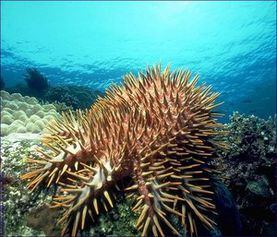
Great Barrier Reef World Heritage Area, Australia
Contents
- 1 Geographical location
- 2 History of establishment
- 3 Area
- 4 Land tenure
- 5 Altitude
- 6 Physical features
- 7 Climate
- 8 Vegetation
- 9 Fauna
- 10 Threats
- 11 Cultural heritage
- 12 Local human population
- 13 Visitation
- 14 Scientific research
- 15 Conservation value
- 16 Conservation management
- 17 IUCN management category
- 18 Further reading
Geographical location
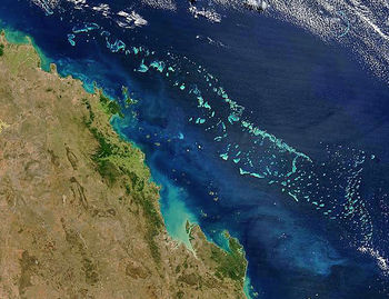 Great Barrier Reef from space. Source: NASA
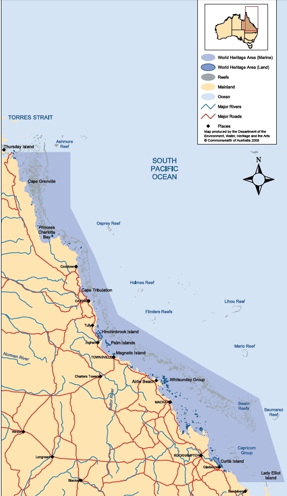
The Great Barrier Reef World Heritage Area is a major marine ecosystem exhibiting the largest extent of coral reefs on Earth; its geographic range (24°30'N to10°41'S, 145°00' to 154°00'E) comprises a World Heritage Site that extends for more than 2000 kilometres within the Coral Sea off the eastern coast of Australia, from immediately south of the Tropic of Capricorn to the [[coast]al waters] of Papua New Guinea.
History of establishment
The Great Barrier Reef Marine Park Act 1975 provides for the establishment, control, care and development of a Marine Park covering 98.5% of the Great Barrier Reef Region as defined in that Act. Parts of Green Island (1937) and Heron Island (1943) were gazetted as national parks under the State Forests and National Parks Act 1903-1948 (Queensland). Heron-Wistari and Green Island Marine Parks (1974), gazetted under the Forestry Act 1959-1976 (Queensland), were the first Marine Parks on the reef. Areas of the region may be declared as part of the Marine Park and subsequently zoned. In 1976 these powers were transferred to the National Parks and Wildlife Act 1976 and Fisheries Act 1976, respectively. The first section of the Great Barrier Reef Marine Park, the Capricornia Section, was proclaimed in 1979. The Cairns and Cormorant Pass sections were declared as part of the Marine Park in late 1981 and the remainder of the Marine Park in subsequent years. The whole area was inscribed on the World Heritage List in 1981.
Dates and History of Establishment
| 1937 & 1943 | Parts of Green Island and Heron Island were gazetted as National Parks under the State Forests and National Parks Act of 1903/1948 (Queensland); |
| 1974: | Heron-Wistari and Green Island Marine Parks gazetted under the Forestry Act of 1959-1976 (Queensland) as the first Marine Parks on the reef; |
| 1975: | The Great Barrier Reef Marine Park Act 1975 provided for the establishment, control, care and development of a Marine Park covering 98.5% of the Great Barrier Reef Region as defined in that Act; |
| 1976: | These powers transferred to the National Parks and Wildlife Act and Fisheries Act both of 1976; |
| 1979: | The Capricornia Section, the first section of the Great Barrier Reef Marine Park (GBRMPA) proclaimed; |
| 1981: | The Cairns and Cormorant Pass sections declared part of the Marine Park. The remaining sections of the Marine Park were included between 1987 and 1989. |
| 1990: | Proclaimed a Particularly Sensitive Sea Area, extended in 2002 to Torres Strait. |
Area
World Heritage Area 34,870,000 hectares (ha) (includes Far North, Cairns, Central and Mackay Capricorn Sections), Marine Park 33,126,500 ha. The islands that form part of Queensland are not covered by the Great Barrier Reef Marine Park Act and are not included as part of the Marine Park, but are included in Great Barrier Reef Marine Park Authority's (GBRMPA) work program as it is funded by day to day management funds.
Land tenure
The Coastal Waters (State Title) Act 1980 (Commonwealth of Australia) vested title to the seabed inside the outer limits of the three-mile territorial sea in the State of Queensland, subject to a number of reservations including, in particular, the continuing operation of the Great Barrier Reef Marine Park Act 1975. Exclusive rights to explore and exploit the seabed of the Continental Shelf beyond the territorial sea are vested in the Commonwealth (Federal Government) subject to certain limited rights conferred on third parties. Within the limits of the State of Queensland, public title is vested in the State of Queensland, apart from public lands owned by the Commonwealth. Some land is held by private persons.
Altitude
The topography of the Great Barrier Reef region is characterised by elevations ranging from below sea level generally to 40 metres (m); however, the jurisdiction of The Great Barrier Reef Marine Park Act 1975 applies to activities occurring from 1000 m below the sea bed to an altitude of 915 m above sea level.
Physical features
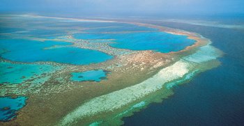
Includes the world's most extensive stretch of coral reef. The reef system, extending to Papua New Guinea, comprises some 3400 individual reefs, including 760 fringing reefs, which range in size from under one hectare to over 10,000 ha and vary in shape to provide the most spectacular marine scenery on earth. There are approximately 300 coral cays, including 213 unvegetated cays, 43 vegetated cays and 44 low wooded islands. There are also 618 continental islands which were once part of the mainland.
The form and structure of the individual reefs show great variety. Two main classes may be defined:lying platform or patch reefs, resulting from radial growth; and wall reefs, resulting from elongated growth, often in areas of strong water currents. There are also many fringing reefs where the reef growth is established on subtidal rock of the mainland coast or continental islands.
Capricorn-Bunker Group National Park (Queensland State) encompasses a terrestrial section and consists of four islands: Fairfax Island, a coral cay consisting of two small islands on an egg-shaped reef; Hoskyn Island similar to Fairfax, though not a cay; Heron Island, sand and broken coral on coral and rock formation; and Lady Musgrave Island, a cay surrounded by extensive coral reefs.
Water circulation is very complex, governed by properties of the Coral Sea, land run-off, evaporation, the south-east trade winds, forced upwellings due to strong tidal currents in narrow reef passages and coastal waters including mangroves. Tides are generally semi-diurnal with diurnal inequality towards the north, becoming almost diurnal in Torres Strait. The maximum tidal range is about three metres along most of the coast, although increasing to six to nine metres in the Broad Sound area between 21° and 23°S. Water is vertically well-mixed for most of the year with stratification occurring due to freshwater input during January to April. Freshwater run-off can be very localised and significant physical and biological effects may be expected.
Climate
The Great Barrier Reef has a tropical climate influenced primarily by two features of the southern hemisphere circulation: the equatorial low pressure (Atmospheric pressure) zone during the summer months and the sub-tropical high pressure zone during the winter months. As the area lies between the continental land mass of Australia and the open ocean of the South Pacific, its climate is also strongly influenced by both the adjacent land mass and oceanic effects. Wind patterns are dominated for the greater part of the year by the southeast tradewinds. During January to March, north-westerlies prevail in the north of the area under the influence of the inter-tropical monsoonal front. The rainfall is seasonally and geographically variable. The wettest period is summer, under the influence of the monsoon and irregular tropical cyclones and depressions. Heavy rain may occur in the south during winter. Air temperatures vary between an average maximum of approximately 30°C in January and 23°C in July and an average minimum of approximately 24°C in January and 18°C in July. Mean water surface temperature is at a maximum during February and at a minimum during July.
Vegetation
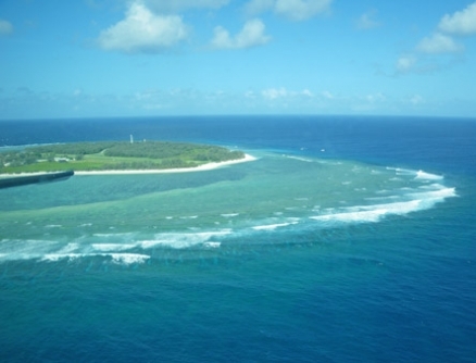
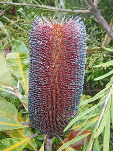 Upland vegetation, Lady Elliot Island.
Source: C.Michael Hogan This is the world’s largest coral reef ecosystem with over 200,000 hectares of mangroves, and over 300,000 hectares of sea grasses. 4,000,000 hectares of lagoon are vegetated. There are 2195 species of native plants, over a quarter of Queensland’s species, of which three are endemic. 300 to 350 species are found on coral cays in the north, two being endemic, and 120 on cays in the south.
The Whitsunday Islands have the highest diversity with 1141 species. Some 70 species are nationally threatened or rare. Globally endangered plants include the orchid Habenaria divaricata (EN) and eight species listed as vulnerable. This is the southern limit for several pantropical species. Island vegetation is dominated by Pisonia grandis on Heron and Lady Musgrave islands. Hoskyn Island, with a forest of Pandanus with Pisonia and Ficus apposita, is unique to the group. Vegetation also includes Casuarina, grasses such as Thuorna insula and Lepturus sp., Abutilon indicum, Candia subcordate and Poinsettia sp. A wide range of fleshy algae occurs, many of which are small and inconspicuous but which are highly productive and are heavily grazed by turtles, fish, molluscs and sea urchins. In addition, algae are an important component of reef building processes. Fourteen species of seagrass grow throughout the reef area and are an important food source for grazing animals, although they are rarely abundant. Extensive seagrass beds may be found in inshore waters, providing important grazing for dugongs.
There are 37 species of mangrove, 54% of the world’s mangrove species. Fifteen species of sea grass grow throughout the area in inshore shallows. They are rarely abundant but are an important food source for grazing animals, especially dugong (Kelleher et al.,1989). Dominant species are Halophila ovalis, Halodule uninervis and Zostera capricornis. There are some 400 to 500 species of marine algae of every type, including 26 macroalgae and a recent invader from the north, the golden algae Chrysocystus fragilis, which blankets and kills coral. The wide range of fleshy algae, many of them small and inconspicuous, are highly productive and heavily grazed by turtles, fish, molluscs and sea urchins. The coralline algae are an important component of reef building.
Fauna
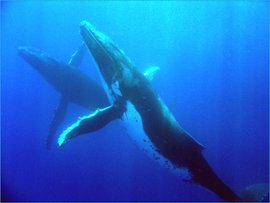
There are over 1500 species of fish, 400 species of coral, 4000 species of mollusc and 242 species of bird within the park, plus a great diversity of sponges, anemones, marine worms and crustaceans. The site includes major feeding grounds for dugong Dugong dugon (V). Several cetaceans are present, including humpback whale Megaptera novaengliae (E), Minke whale Balaenoptera acutorostrata and killer whale Orcinus orca. Dolphins include Bottlenose Tursiops truncatus, Irrawaddy Orcaella brevirotris (K) and Indo-Pacific humpback Sousa chinensis. Offshore, spinner dolphin Stennella longirostris is also occasionally seen. There are nesting grounds of world significance for green turtle Chelonia mydas (E) and loggerhead Caretta caretta (CR), and habitat for four other species of marine turtle: hawksbill Eretmochelys imbricata (CR), leatherback Dermochelys coriacea (CR), Pacific olive ridley Lepidochelys olivacea (EN) and flatback turtles Natator depressus.
The estuarine crocodile Crocodylus porosus can be found along the whole coast, especially in the north where the very poisonous box jellyfish Chironex fleckeri also occurs inshore. Freshwater crocodiles Crocodylus johnstoni are rarely recorded. Seasonally, between 1.4 and 1.7 million birds gather in the area. Of 215 species, at least 40 are seabirds, 29 of which breed on the Reef. Seabirds include wandering albatross Diomedea exulans (VU), white-breasted sea eagle Haliaeetus leucogaster, red-tailed tropicbird Phaethon rubricauda, herald petrel Pterodroma heraldica, little tern Sterna albifrons, and roseate tern S. dougallii, the largest roost of which in southeast Asia is on Swain’s Reef. . 118 species of butterfly are recorded (30% of Australia’s total) (GBRMPA, 2000).
Threats
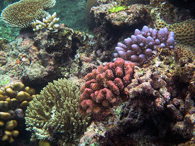 A medley of coral. Source: Steve Evans
Within the last 3000 years during the ascent of humans, there has been a steady decline in ocean water quality, chiefly from discharge of sediment and sewage to the world's oceans. The Great Barrier Reef has been a recipient of these impacts along with other world regions, even though local impacts are less that, for example, the Indian Ocean, where population pressures have been higher.
The past three decades have witnessed an accelerated degration of the world's ocean water quality, not only from sedimentation and sewage discharge, but increasingly from agricultural fertiliser and herbicide usage.For example, land clearance and road construction with unsealed surfaces has led to a fourteen fold increase in sediment discharge in the Cape Tribulation area, quite near to fringing reefs. These activities are causes of reef degradation.
The six chief threats to the World Heritage values of the property are: coral bleaching due to climate warming; catchment water quality and runoff from [[coast]al] developments; the impacts of intensive fishing levels (bottom prawn trawling, line, net and pot fishing); the impacts of increasing tourism and recreational use; biodiversity loss from oil and other pollutants and predation by red foxes, feral cats and pigs; and cyclic outbreaks of crown of thorns seastars.
Based upon known data the impacts of humans related to land degradation likely contribute far more reef damage than by hypotheses of seawater warming. Since the total pollutant load is actually a worldwide issue, it is important for the world community to address this matter of threats to coral systems as a global responsibility. The nitrate runoff from a farm in France and the untreated sewage from a village in Zimbabwe are contributory to the problem and must be addressed in the solution.
Increasing recreational use had become a threat in itself. Unacceptable ecological impacts from reef-based tourism include the discharge of waste, litter and fuel, physical damage to reefs from anchors, people snorkelling, diving and reef walking, disturbance of fauna, especially seabirds, and over-fishing or collecting. With other factors these have contributed to the decline of turtle and dugong populations. All of these impacts may be managed to some extent by design, prohibition or limitation. However, the Port Hinchinbrook Resort (1500 beds, 250 berth marina with jet airstrip and seaplane access proposed) was built in the 1990s on the Hinchinbrook Channel within the World Heritage area at Oyster Point near Cardwell. It had local, state and federal support, and was completed despite strong conservation opposition. Its impacts are monitored but the development set a precedent for similar activities. The development of faster speedboats mean that 81% of the park can now be accessed on a day-trip. Numbers of fish and other marine fauna are declining; there has been an apparent 90% decline in dugong numbers south of Cooktown since the 1960’s and a 70-90% decline in loggerhead turtles since 1970. The various turtle populations are threatened by habitat loss, fishing net kills and hunting
Cultural heritage
The Great Barrier Reef, and in particular the northern sector, is important in the historic and contemporary culture of the Aboriginal and Torres Strait Islander groups of the [[coast]al areas] of northeast Australia. This contemporary use of and association with the Marine Park plays an important role in the maintenance of their cultures and there is a strong spiritual connection with the ocean and its inhabitants. Little systematic archaeological study has been done but it is known that there are large, important Aboriginal and Torres Strait Islander sites on a number of the islands. Some notable examples occur on Lizard and Hinchinbrook Islands and on Stanley, Cliff and Clack Islands in the vicinity of Cape Melville (14°S) where there are spectacular galleries of rock paintings. About 30 wrecks of historic importance are known to exist in the area. One of the earliest, the wreck of HMS "Pandora" dating from 1791, lies near the reef in the northern sector to which it gave its name. The hazards of navigation in the Great Barrier Reef resulted in the construction of a large number of lighthouses, some of which have particular historical importance. The lighthouses at Lady Elliott Island (1866) and North Reef Island (1878) still operate and are fine examples of 19th century riveted steel plate construction.
Local human population
Currently, people living in Aboriginal and Torres Strait Island communities in the Great Barrier Reef area (Palm Island, Inginoo, Bamaga, Sesia, New Mapoon, Umagico, Yarrabah, Wujal Wujal, Hopevale, Cooktown and Lockhart River) as well as other urban centers, have access to marine and near-shore resources which have played an important role in their economy during the past several thousand years. There are also white Australians living in the area on various islands. In economic terms the most significant activity taking place on the reef is tourism, generating an estimated Aus $1 billion (US$ 750 million) per year.
Visitation
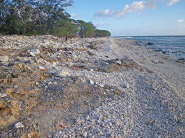 Example littoral zone within the Great Barrier Reef,
Lady Elliot Island. Source: C.Michael Hogan In 1993, it was estimated that 2,291,000 tourists, carried by 542 commercial vessels, visited the Great Barrier Reef Marine Park. These people spent over 1.8 million visitor nights on the reefs and islands. Resort guests make extensive use of reefs and waters for recreational activities, including fishing, diving and snorkelling, water sports, sightseeing, reef-walking and some shell collecting. Tourism is allowed to occur under permit within all, except preservation and scientific research zones, that is in 99.8% of the Marine Park. Whilst the area designated free from tourism or fishing may seem low, it must be recognized that the Marine Park encompasses large areas of open water, so that the proportion of reef so designated is, in practical terms, much higher.
Scientific research
The Great Barrier Reef offers unparalleled opportunities for scientific research. Research activities in the area have continued to develop since the formation of the Great Barrier Reef Committee (now the Australian Coral Reef Society) in 1922 and the British Great Barrier Reef Expedition to the Low Isles in 1928-29. The need for such research has become more critical in recent years with the Reef's inclusion on the World Heritage List, concern resulting from crown-of-thorns starfish outbreaks and intensifying human demands placed on the resource. While research on the Reef continues to be conducted by scientists from most Australian universities and institutions, concerted efforts are concentrated, for logistical reasons, on field research stations and North Queensland mainland centers.
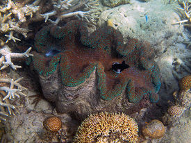 Giant clam in clear shallow waters. Source: Steve Evans
For local and visiting overseas scientists, field stations are operated by the University of Queensland (Heron Island), the University of Sydney (One Tree Island), James Cook University and the Australian Institute of Marine Science (AIMS). The latter two, both located in Townsville, have extensive coral reef research programs that cover the full ambit of scientific disciplines. Research into ecologically sustainable development of the Marine Park is integrated within the Cooperative Research Centre, which includes the AIMS, Great Barrier Reef Marine Park Authority (GBRMPA), Queensland Department of Primary Industries, James Cook University and Association of Marine Park Tourist Operators. The GBRMPA research program is currently grouped into five programs: water quality; effects of fishing; crown-of-thorns-starfish monitoring; and socio-economic. Most research is carried out by outside agencies under contracts with the Authority, but much of the monitoring (Environmental monitoring and assessment) activity is directly coordinated by Authority staff. Other research is listed in Frankel (1978), Baker et al. (1983), Bellwood (1994) and GBRPMA (1994).
Assessments made include a coral bleaching forecast system, ecosystem vulnerability, resilience indicators, defining social resilience and frameworks for social assessments. Outcomes include policy congruence, international recognition, research coordination and investment, stakeholder and NGO partnerships, community partnership teams, programs such as Bleach Watch, part of an early warning system, and production of a Tourism Leaders Forum and a Manager’s Guide to Coral Bleaching. The Coral Bleaching Response Plan to detect and measure bleaching and other impacts using satellite imagery, aerial and underwater surveys, and community observations received worldwide recognition. The Authority’s bleaching management programs are recognised as the world’s best practice. The Great Barrier Reef has had relatively low bleaching to date. The main challenge is to increase the broad resilience of the Marine Park and in 2004, the GBRMPA increased the percentage of no-take area in the Park from 4.5% to 33%
Conservation value
The Great Barrier Reef is an area of remarkable biological diversity and beauty on the northeastern coast of Australia. It contains the world's largest collection of coral reefs, with some 400 types of coral, 1,500 species of fish and 4,000 types of mollusc. It is an area of great scientific value and also provides a habitat for many threatened species including green turtle and dugong.
Conservation management
The Great Barrier Reef Marine Park Act 1975 provides for: the establishment of the GBRMPA; the specification of the Authority's functions; the establishment of a Consultative Committee made up of representatives of government, industry and community bodies; and the prohibition of drilling and mining in the Marine Park except for approved research purposes. The GBRMPA comprises a Chairperson and two part-time members nominated by the Commonwealth Government (one of whom represents the Aboriginal and Torres Strait Islander communities living adjacent to the Marine Park) and a part-time member nominated by the Queensland Government.
The Act, its regulations and zoning plans have primacy over conflicting provisions of both Commonwealth and Queensland legislation, except in relation to the navigation of ships and aircraft. Constitutionally, the Queensland Government has responsibility within the area for those waters which were internal waters at the time of Federation and for all islands above the low water mark within the outer boundaries of the Great Barrier Reef Region, except for those few which are owned by the Commonwealth of Australia.
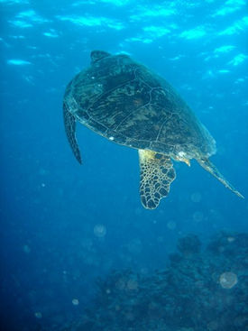 Green turtle (Chelonia mydas) in the Great Barrier Reef
Source: Annemarie Kohl & Nicolai Schafer
The Act and the responsibilities of the Authority extend over the whole Great Barrier Reef Region, generally up to low water on the Queensland [[coast]line] and islands. There are some exceptions to this which are primarily in areas where there are existing or potential harbor facilities, and the potential impact of activities in such areas on the reef is judged to be minimal. Management of the park is achieved by a cooperative arrangement between the Commonwealth and Queensland governments using a number of mechanisms, including a Ministerial Council comprising two ministers from each of the two governments, the Consultative Committee and close liaison at an officer level. The arrangement recognizes that the islands, [[reef]s] and waters of the area are a continuum and that they should be managed on a complementary basis. Since the site was inscribed on the World Heritage List, the Great Barrier Reef Marine Park Act has been amended to provide for: increased powers for inspectors; increased penalties; extended search and seizure powers outside the Marine Park; powers to remedy actual damage or prevent possible damage; allow costs of clean-up operations to be recovered from convicted offenders; and to allow the Marine Park Authority to assist other institutions and individuals in environmental issues.
The Queensland Government has introduced the Queensland Marine Parks Act 1982, 1989 and Regulations which provides for zoning and management plans for areas in the Great Barrier Reef region not included in the Marine Park, and areas adjacent to the region. The major pieces of Queensland legislation identified in the nomination of the property have been changed via provisions of the Nature Conservation Act 1992 and the Fisheries Act 1995.
Fisheries beyond Queensland coastal waters are managed on a cooperative basis with most species being managed by the Queensland Government. The Fisheries Management Act 1995 provides the making of an agreement in relation to the management of fisheries to the States of Australia.
Between 1991 and 1994, a 25-Year Strategic Plan was endorsed by sixty stakeholder groups, with a comprehensive table of all the associated plans for the management of the Marine Park. In 1998, the State of the Great Barrier Reef World Heritage Area provided the first comprehensive synthesis of all available information on the property and stated that the ecosystem as a whole was in good health (GBRMPA, 2001), though this preceded the bleaching event of 2002. In late 1999, Australia drew up a set of recommendations and a management framework in five priority areas: 1) the management of land & coastal catchments, 2) the management of fisheries, 3) the management of shipping & ship-sourced pollution, 4) representative marine protected areas, and 5) resources for research & management. In 2001, the Marine Park Authority released its Great Barrier Reef Catchment Water Quality Action Plan recommending end-of-river pollution targets for all 26 catchments adjacent to the Reef for 2011. Following the bleaching event of 2002, measures such as an annual Coral Bleaching Response Plan and a 5-year Climate Change Action Plan to monitor, study and combat coral bleaching have received high priority.
Zoning plans under the Act have now been prepared for all four sections of the Park. These are the Mackay/Capricorn, Central, Cairns and Far Northern sections, and buffer zones are incorporated into the zonation to protect areas of relatively higher conservation value. The Great Barrier Reef Marine Park Act introduced the concept of controlled multiple-use planning and management of marine areas through zoning and permissible activities. Queensland Marine Parks legislation was amended to allow mirror zonings where necessary, in order to minimize public confusion at the interface between the areas of jurisdiction of the two governments.
Plans to counteract some of the other major pressures on the Park have been drawn up for water quality, fisheries and tourism. Water quality measures include end-of-river pollution targets; codes of practice for agricultural industries; and timelines for the upgrading of sewage discharge facilities. The Federal government is working closely with the state government on the Reef Water Quality Protection Plan, which aims to reverse the decline in the quality of water entering the Marine Park by 2013. Tourism measures include statutory plans of management; a register of best environmental practices; and a reef-wide mooring policy. Another major element in managing and protecting the Reef is the education of reef users to appreciate the environment and to exercise care when visiting it. The Authority has an education/ information section which produces programs and materials for public education and assists tourist operators in the development of conservation and education activity programs for visitors . One of the highest monitoring levels of any World Heritage area is claimed for the Park. This is conducted mainly by the Cooperative Research Centre and the Australian Institute of Marine Science. Major monitoring themes are coral bleaching, long-term coral reef health, seagrass watch, chlorophyll production, and coordinated water quality. Large monitoring projects include the impacts of commercial and recreational fishing on the sustainability of fish stocks in the Park.
The second major management tool available to the Authority in conjunction with the Queensland Department of Environment and Heritage, apart from zoning, is the power to make statutory management plans for areas, species or ecosystems within the Marine Park. In addition, the GBRMPA has the authority to refuse or grant permits for a broad spectrum of activities that may take place within the Marine Park. These activities include tourist facilities and programs, education and research programs, aircraft operations, discharge of waste, collecting, installation and operation of moorings and traditional hunting and fishing.
The education of reef users to appreciate the reef environment and exercise care when visiting the reef, is a third major element in managing and protecting this resource. The Authority has an education/information section which produces programs and materials for public education and assists tourist operators in the development of activity programs that are conservationally and educationally focused for visitors.
Management constraints
There is a conflict between the various uses of the reef and the desire to see it maintained in its pristine state. Some uses of parts of the reef have already reached levels that fully exploit the productive capacity of the system. Surface water runoff from islands and the mainland contains suspended solids, [[herbicide]s], pesticides, nutrients, and other materials which may have an effect on the reef, via marine water pollution. earch in the Great Barrier Reef lagoon near to Low Isles indicate that significant increases in phytoplankton concentrations have occurred in the last 65 years. There are strong indications of anthropogenic eutrophication, most likely from agricultural runoff, with possibly widespread impacts on many reefs.
Prevention of unacceptable ecological impact is paramount in the GBRMPA management of tourism development. The type of impact which may be associated with reef-based tourism operations include: discharge of waste, litter and fuel, physical damage to reefs from anchors, people snorkelling, diving and reef walking, disturbance of fauna (especially seabirds), overfishing or collecting. All of these may be managed to some extent by design, prohibition or limitation. Two reports identify increasing tourist use as a problem, especially as the continuing development of faster speedboats mean that 81% of the park can now be accessed on a day-trip.
Deteriorating water quality, effects of fishing and outbreaks of crown of thorn starfish, have been identified as the other major issues facing the park. There were also concerns over declining numbers of fish and other marine fauna. For example, dugong occurring south of Dunk Island have decreased by 50% over the last eight years, and the various turtle populations are still considered to be threatened by habitat loss, incidental kills in fishing nets, and hunting. Large projects include the impacts of commercial and recreational fishing on sustainability of fish stocks in the Marine Park. A large tourism and marina development at Port Hinchinbrook, Oyster Point has recently caused controversy. The development was temporarily halted by the Federal Minister in 1994 whilst the issue was taken to the Federal court. In February 1997 it was ruled that the development be allowed to continue, and the case is currently under appeal. There are concerns that in addition to the negative impacts of the development, the case will set a precedent for similar activities.
Studies in the lagoon near the Low Isles indicated significant increases in phytoplankton concentrations in the last 65 years. Runoff from islands and the mainland contains sediments, herbicides, pesticides, nutrients, and other materials damaging to the reef . The hazard of oil spills from the many ports and from shipping routes carrying 6000 ships a year, 10% of them with oil and chemicals, is greatest in the Whitsunday Islands, near Cairns and between Cape Flattery and Cape York. Pilotage for large vessels is compulsory and dumping of any kind from any vessel, aircraft or platform is illegal.
Staff
In 1994/95, the Authority had approximately 150 staff, operating from its principal office in Townsville and a smaller office of nine staff in Canberra. The Queensland National Parks and Wildlife Service has approximately 60 staff involved in the day-to-day management. Field officers are limited in number with only seven being available on any given day to supervise the area between Cooktown and the top of Cape York Peninsula, a [[coast]line] in excess of 800 km. There are 300 Marine Park inspectors working within a range of federal and state services.
Budget
Total gross expenditure by government on the Great Barrier Reef Marine Park for the 95/96 financial year was estimated at AUS$ 26,522,000.
IUCN management category
- V (Protected Landscape)
- Natural World Heritage Site - Criteria i, ii, iii, iv
Further reading
- Anon. (1989). Information update on the cultural sites inscribed on the World Heritage List: Great Barrier Reef. Department of the Arts, Sport, the Environment, Tourism and Territories, Canberra. Unpublished. 3 pp.
- Baker, J.T., Carter, R.M., Sammarco, P.W. and Stark, K.P. (Eds). (1983). Proceedings of the Great Barrier Reef Conference, Townsville. James Cook University and Australian Institute of Marine Science. 545 pp.
- Bell, P.R.F. and Elmetri, I. (1995). Ecological indicators of large-scale eutrophication in the Great Barrier Reef Lagoon. Ambio XXIV (4): 208-215
- Bellwood, O. (ed). (1994). The Sixth Pacific Congress on Marine Sciences and Technology, 4-8 July 1994. PACON'94. James Cook University of North Queensland, Townsville. (Unseen).
- Bennett, I. (1973). The Great Barrier Reef. Frederick Warne and Co. Ltd. London. ISBN: 0701803584.
- R.W.G.Carter and C.D.Woodroffe. 1997. Coastal evolution: Late Quaternary shoreline morphodynamics. Cambridge University Press. 539 pages
- Driml, S. (1994). Protection for Profit. Research Publication Series No. 36. Great Barrier Reef Marine Park Authority, Townsville, Queensland. 83 pp. (Unseen).
- Engelhardt, U. and Lassig, B. (eds). (1993). Proceedings of a Workshop held in Townsville, Queensland, Australia, 10 June 1992 at the Sheraton Breakwater Casino Hotel. (Unseen).
- Frankel, E. (1978). Bibliography of the Great Barrier Reef Province. Great Barrier Reef Marine Park Authority, Australian Publishing Service, Canberra. Lists 4444 publications dealing with the site and its environs. ISBN: 0642036454.
- GBRMPA (1978). Workshop on the Northern Sector of the Great Barrier Reef. Great Barrier Reef Marine Park Authority, Townsville, Queensland. 462 pp.
- GBRMPA (1985). Australian marine research in progress. Great Barrier Reef Marine Park Authority, Townsville, Queensland. 245 pp.
- GBRMPA (1994). 1993-1994 Annual Report. Great Barrier Reef Marine Park Authority, Townsville, Queensland.
- Haigh, D (1997) Australian Federal Court rules on Great barrier Reef Case World Heritage News 12.5 (17 February 1997).
- Hillman, S. (1996) The state of the Great Barrier Reef World Heritage Area report Reef Research 6(1).
- McPhail, I (1996) Managing the Great Barrier Reef Marine Park: The Changing Environment of Managing Use in the Great Barrier Reef World Heritage Area. Paper presented at the ABARE Outlook '99 conference, Melbourne 1996. Kelleher, G., Childs, R. and Quilty, P. (1989). Great Barrier Reef Area: a protected seascape. Great Barrier Reef Marine Park Authority. Unpublished. 22 pp.
- Steven et al. (1994). Great Barrier Reef Marine Park Authority Water Quality Research program. In: Bellwood, O. (ed). The Sixth Pacific Congress on Marine Sciences and Technology, 4-8 July 1994. PACON'94. James Cook University of North Queensland, Townsville. (Unseen).
| Disclaimer: This article or contains information that was originally published by the United Nations Environment Programme-World Conservation Monitoring Centre (UNEP-WCMC). Topic editors and authors for the Encyclopedia of Earth have edited its content and added new information. The use of information from the United Nations Environment Programme-World Conservation Monitoring Centre (UNEP-WCMC) should not be construed as support for or endorsement by that organization for any new information added by EoE personnel, or for any editing of the original content. |
