Göreme National Park and the Rock Sites of Cappodocia, Turkey
| Topics: |
Contents
- 1 Introduction The Göreme National Park and the Rock Sites of Cappodocia are located in Turkey (38°26'N, 34°54'E) and is a World Heritage Site, with the the park boundaries extending south-west directly to the peak of Pinarcik Tepe (Kayacik Dag) and Kermil Dagi, thence eastwards to Ibrahimpasa, Ortahisar and back to Ürgüp. (Göreme National Park and the Rock Sites of Cappodocia, Turkey)
- 2 Geographical Location
- 3 Date and History of Establishment
- 4 Area
- 5 Land Tenure
- 6 Altitude
- 7 Physical Features
- 8 Climate
- 9 Vegetation
- 10 Fauna
- 11 Cultural Heritage
- 12 Local Human Population
- 13 Visitors and Visito Facilities
- 14 Scientific Research Facilities
- 15 Conservation Value
- 16 Conservation Management
- 17 IUCN Management Category
- 18 Further Reading
Introduction The Göreme National Park and the Rock Sites of Cappodocia are located in Turkey (38°26'N, 34°54'E) and is a World Heritage Site, with the the park boundaries extending south-west directly to the peak of Pinarcik Tepe (Kayacik Dag) and Kermil Dagi, thence eastwards to Ibrahimpasa, Ortahisar and back to Ürgüp. (Göreme National Park and the Rock Sites of Cappodocia, Turkey)
Geographical Location
In Nevsehir Province of Central Anatolia, between Nevsehir city and the towns of Avanos and Urgüp. The park circumference is approximately 40 kilometers (km), extending from the bridge at Ürgüp then leading north for 6 km following the River Damsa. The boundary then heads west, immediately to the north of Zelve and south of the River Kizilirmak, by Avanos to Toprak Tepe. 38°26'N, 34°54'E.
Date and History of Establishment
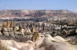 Cappadocia, a region in central Turkey is known for its Goreme National Park. The area is famous for it "fair chimney" rock formations. (Source: Wikimedia Commons)
 - Established on 25 November 1986 as a historical national park under the Law of National Parks No. 2873, following proposals and draft management plans drawn up by the General Directorate of Forestry and National Parks in 1968.
- Protection for Göreme Valley and its surroundings was established in Decree No. A-69 of the High Council of Monuments and Historic Sites promulgated on 10 July 1976 in the "Cappadocia General Conservation Plan". This required the preparation of detailed development plans. The protection of the site is further assured under the Cultural and Natural Assets Act 2863 enacted on 23 July 1983. The site was inscribed on the World Heritage List in 1985.
Area
9,576 hectares (ha).
Land Tenure
Private, although most of the core of the park is in federal ownership.
Altitude
Ranging from approximately 1,000 meters (m) to 1,325 m at Akdag.
Physical Features
The Göreme valley is an eroded plateau in a formerly active volcanic region. The nearby Erciyas Dag volcano is now dormant, although there are still occasional earthquakes in the area. Peaks such as Hasan Dag, Erciyas Dag (both outside the valley) and Akdag, dominates the valley landscape. Andesitic tuff was ejected from volcanic eruptions in the late Pliocene covering an area of about 10,000 square kilometers (km2). This layer of tuff was in turn overlain by a series of andesitic and basaltic lavas, between the late Pliocene and early Pleistocene. The deep layers of soft, quite homogeneous material have been eroded to form regular conical peaks or irregular masses reflecting the differential resistance to weathering. Typical geomorphological features include pillars, columns, towers, obelisks and needles, sometimes reaching a height of 40 m.
Climate
Continental Anatolian climate with hot dry summers and cold winters (winters bring severe frosts and prolonged snow cover). Temperature ranges from 0.5°C in winter (January) to 23°C in summer (July). Rainfall is low and averages 360 millimeters (mm) per year. There are intermittent snowfalls in January and February (average of 25 mm per year).
Vegetation
Comprises a largely agricultural landscape dominated by arable farming and vineyards and orchards. Species found within the park include Thesium scabriflorum (V), Ferula halophila (V), Acantholimon saxifragiforme (R), Onobrychis elata (R), Phryna ortegioides (R), Reseda armena (R) and Silene splendens (R). In addition, some 110 endemic species such as Acanthus hirsutus, Alkanna orientalis, Leontodon oxylepis, and Dianthus zederbauriana occur within the park.
Fauna
Mammal species include grey wolf Canis lupus (V), red fox Vulpes vulpes, otter Lutra lutra, Eurasian badger Meles meles, beech martin Martes foina and brown hare Lepus europeus. Avifauna including rock partridge Alectoris graeca, common quail Coturnix coturnix, feral rock dome Columba livia and falcon Falco sp. have also been recorded in the park.
Cultural Heritage
Under continuous human occupation for at least 16 centuries. From the 4th to 13th century AD, a relatively harmonious landscape has developed, which is integrated into and makes use of the spectacular natural setting. An unusual feature of this area is the network of excavations in the volcanic formations dating back to the fourth century. The 'fairy chimney' and exposed cliff faces have been part excavated and tunnelled so as to form churches and various chambers. These caves served as refuges, residences, stores and places of worship. There are also other classified monuments found within the valley but outside the limits of the park.
Local Human Population
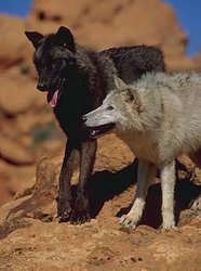 Grey wolves. (Source: Utah Conservation Data Center)
 The park and surrounding area includes a diversity of towns, villages and small rural hamlets, with approximately 20,000 people living within the park and some 65,000 within the surrounding community. The local population is traditionally dependent upon agriculture, pottery and weaving of rugs and carpets. In the 1980s tourism has become one of the dominant economies of the region.
Visitors and Visito Facilities
The park received 593,000 visitors in 1994. Of these, 14% comprised local people and the remainder foreign visitors, whose average length of stay was two days. The main center for visiting the national park is at the town of Göreme where there is a diversity of facilities including interpretative trails, hotels and camping accommodation, information services, restaurants, shops and transport. There are also three visitor centers outside the park. Thereis an open air museum a few kilometers from Göreme, which encloses many of the historical church structures dating from Byzantine times.
Scientific Research Facilities
A series of studies have been carried out in collaboration with the Internaitonal Centre for the Study of the Preservation and Restoration of Cultural Properties (ICCROM), United Nations Educational, Scientific and Cultural Organization (UNESCO) and United Nations Development Programme (UNDP) since 1973. Architectural photogrammetric studies have been undertaken by METU (Middle East University in Ankara) and a series of geological and hydrogeological studies by UNESCO/ICCROM/UNDP consultants.
Work on the restoration of the murals of the 'Tokali Church' was carried out with the assistance of specialists from ICCROM. A number of the unit's staff have also received training at ICCROM in Rome. The work at Tokali was completed in 1980 and work begun in Karanlik in 1981. The conservation of the structures have been carried out by METU and UNESCO/ICCROM/UNDP consultants.
Conservation Value
Göreme Valley and its surroundings comprise an area of spectacular landscape which have been entirely sculptured by erosion. The sanctuaries cut into the rock provide irreplaceable evidence of Byzantine art from the post-iconoclastic period. Dwellings, troglodyte villages and underground towns date back to the 4th century and represent a traditional human habitat.
Conservation Management
The area was established as a historical national park in order to protect and develop the national and cultural elements of the area for scientific and aesthetic reasons. Management of Göreme depends greatly on the indigenous population maintaining traditional agriculture and lifestyles. The master plan proposes only nominal disturbance of the traditional pattern of life of the present day park residents. The General Directorate of Antiquities and Museums, Ministry of Culture and Tourism, Ankara, and the General Directorate of Forestry, National Park Department in the Ministry of Agriculture, Forestry and Rural Affairs, are jointly responsible for the site.
The protection of identified important areas is achieved by land-use zoning and by restriction and regulation of building and the preservation of traditional values. The strictly protected Zone 1 is the core of the park and includes within its boundary the principal antiquities and elements requiring protection. The two villages, Avcilar (Göreme) and Çavusin are part of this zone. Zone 2 forms a buffer zone around Zone 1: all land-use activities, including agriculture is permitted but regulated within the framework of existing law.
Managment Constraints
The chief management problem is the serious damage being caused to the ancient churches and paintings. Water is causing [[erosion]al] damage and stains to a number of chapels. Natural erosion and earthquakes are still seriously damaging many of the Byzantine chapels. Collapsing walls and rockfalls are not uncommon in the more remote rock dwellings of the park.
Staff
Some staff provided by The Ministry of Culture and Governorship of Nevsehir.
Budget
US$10,000.
IUCN Management Category
- V (Protected landscape)
- Natural/Cultural World Heritage Site - Natural Criteria unknown/Cultural Criteria i, iii, v
Further Reading
- Baggley, G.R. et al. (1968). A master plan for the preservation and use of Göreme national park. Ankara, Turkey.
- Bowen, R., Lizzi, F., and Verite, J. (1983). Draft report for the structural conservation of rock hewn churches of Göreme in Cappadocia. ICCROM/UNESCO/UNDP, Rome.
- General Directorate of National Parks and Wildlife (1980). National Parks of Turkey. Ministry of Forestry, General Directorate of National Parks and Wildlife, Ankara.
- Giovanni, Luciano. (1971). Arts de Cappadocia. Edition Nagel, Geneva, Switzerland. ISBN: 0214653722.
- de Jerphanion, G. (1925). Les Eglises Rupestres de Cappadocia. Librairie Orientaleste Paul Geuther, Paris.
- Mora, P. et Mora, L. (n.d.). La conservation des peintures murales. ICCROM.
- Orman Genel Müdürlügü. (1987). Göreme Historical National Park. Milli Parklar Dairesi, Bakanligi, Ankara.
- Schawartzbaum, P. (1978). Conservation of churches in the Göreme Valley. ICCROM.
- U.S. Agency for International Development. (1968). Göreme National Park, A master plan for the preservation and use of. Report by the US Agency for International Development, US National Park Service Planning Team to Jordan.
- Vural, M. and Kol, Ü. (1992). The flora of Göreme National Park. University of Gazi/Ankara.
- World Heritage Nomination (1985). Göreme Historic National Park. World Heritage Nomination.
| Disclaimer: This article is taken wholly from, or contains information that was originally published by, the United Nations Environment Programme-World Conservation Monitoring Centre (UNEP-WCMC). Topic editors and authors for the Encyclopedia of Earth may have edited its content or added new information. The use of information from the United Nations Environment Programme-World Conservation Monitoring Centre (UNEP-WCMC) should not be construed as support for or endorsement by that organization for any new information added by EoE personnel, or for any editing of the original content. |