Forest profile of Uganda
The forest profile of Uganda features a number of distinct forest types including: Lowland forests, upland forests, swamp forests, open forests and dryland shrub. In the past four decades substantial deforestation has occurred in most of the nation's woodlands.
Contents
Extent of Forest and other Wooded Land
Uganda has experienced a rapid drop in forest cover since the 1970's increasing population and demand for natural resources have led to conversion of forests to agriculture and other uses. The following figures from the United Nations Food and Agricultural Organization demonstrate a decrease in forest area of a quarter between 1990 and 2005.
Table 1. Area of forested and wooded land in Uganda (km2) (% of total area of country)
| 1990 | 2000 | 2005 | |
|---|---|---|---|
|
Forest |
49,244 (20.6%) |
40,593 (16.8%) |
36,267 (15.0%) |
|
Other wooded land |
14,037 (5.8%) |
12,349 (5.1%) |
11,505 (4.8%) |
|
Forest and other wooded land |
63,281 (26.3%) |
52,942 (22.0%) |
47,772 (19.8%) |
|
Other land |
133,829 (55.5%) |
144,158 (59.8%) |
149,328 (62.0%) |
|
Total land area |
197,110 (81.8%) |
197,100 (81.8%) |
19,7100 (81.8%) |
|
Inland water bodies |
43,940 (18.2%) |
43,940 (18.2%) |
43,940 (18.2%) |
Uganda's forests were estimated to be 70% privately owned, and its other wooded lands 79% privately owned. In 1990, 50% of publicly-owned forests were set aside for conservation in national parks or wildlife reserves of some kind. By 2005, that had risen to 58% as forest not set aside for conservation were steadily convert to uses other than forests.
Description of Forests
The United Nations Food and Agricultural Organization distinguishes between closed forests, where the tree canopy covers a high proportion of the land area (definitions vary but 50-100% is common), and open forest, where the tree canopy covers a low proportion of the land area (20-70% is typical).In the following sections on lowland forests, upland forests and swamp forest, closed forests are being referred to; while open forests are addressed in the following section.
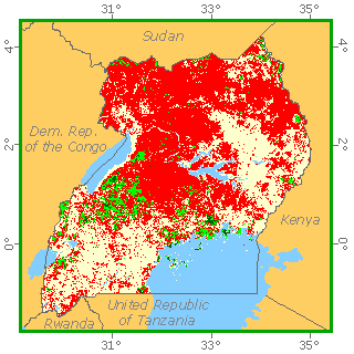 Forest Cover of Uganda. Source: United Nations Food and Agricultural Organization (2000) Forest Cover of Uganda. Source: United Nations Food and Agricultural Organization (2000)
|
|
|

Lowland forests
Two major Lowland (below 2000 meters in elevation) forest areas remain in Uganda, the forests around Lake Victoria and those of the Western/Albertine Rift Escarpment.
The forests of the Lake Victoria belt start from Jinja, where the Nile leaves the lake, and continues westward along the northern shore of the lake, down the western shore and toward Tanzania (east of the Nile very little is left of the dense forest that probably covered large areas in former times). These forests also cover some of the islands in the lake.
The forest lie around 1200 meters (m) and extend inland for 50 to 60 kilometers.
Generally, the hilltops are covered by short grass vegetation, the hillsides by a mixture of cultivated areas and elephant grass thickets and the valleys by forests and swamps.
Although there are many different communities in the climax forests in the lake Victoria belt, there is a tendency towards dominance by the genera Celtis, Chrysophyllum, Aningeria, and Piptadeniastrum with lesser important species such as Morus, Holoptelea, Antiaris and Alstonia. Trichilia, Teclea, Lychnodiscus, Lasiodiscus and Acalypha occur in the understorey.
The species that usually characterise the succession of secondary forests are Albizia, Antiaris, Blighia, Canarium schweinfurthii, Celtis africana, C. durandii, Entandrophragma, Fagara, Lovoa, Majidea and Pycnanthus.
The lowland forests in the Western/Albertine Rift Escarpment form a belt of large forests between 500 to 1650 m elevation. The rainfall ranges from 1250 to 1625 mm. The forest areas are separated by farmlands and various types of "post-cultivation" vegetation, mainly elephant grass thicket and Hyparrhenia grassland. Formerly, many of the existing forests must have been connected with each other and with the Ituri forest in the Democratice Republic of Congo (Zaire). These changes must have partly occurred due to climatic variation, since it seems unlikely that human activities alone would account for them.
These forests, unlike the lake Victoria belt forests, have a tendency toward monospecific dominance. After the initial colonising forest, a mixed forest appears with Alstonia congensis, Trichiliaprieuriana, Khaya anthotheca, Khaya anthotheca, Celtis mildbraedii, and Cynometra alexandri, among others. Its composition varies from place to place. The climax forest that develops afterward depends on the altitude.
From 1000 to 1200 m, Cynometra alexandri is highly dominant (Uganda ironwood). Lasiodiscus mildbraedii and sometimes by Celtis spp. and Strychnos mitis sometimes dominate the understorey.
Very large trees other than Cynometra alexandri occur, such as Khaya spp. and Entandrophragma spp. Patches of characteristic colonising species (e.g. Maesopsis spp.) mature alongside climax canopy species in a mosaic pattern in spaces left by the fall of large trees.
Another type of climax community is the Parinari forest, consisting of almost pure stands of Parinari excelsa, associated in the understorey with Carapa grandiflora. Other understorey species are Craterispermum laurinum, Trichilia prieuriana and Pleiocarpa pycnantha.
Large patches of lowland bamboo (Oxytenanthera abyssinica) are found in the Acholi and West Nile districts. They are four to nine metres high, not very dense, and have a sparse ground layer.
Upland forests
Grassland and cultivated areas usually separate the upland forests (above 2000 m) from the lowland or medium altitude forests. In the Western Escarpment these reach a maximum altitude of about 1650 m, and from here on, up to about 2100 m, much of the original forest has been removed. Only in the south-west does continuous forest cover extend from 1500 up to 2400 m, called "the impenetrable forest".
The upland forests in Uganda are considered to extend to about 3150 m. Their composition varies from mountain to mountain, but four principal communities, Juniperus forest, Chrysophyllum forest, bamboo thicket and Hagenia-Rapanea woodland, are found.
Depending on the elevation, three zones can be distinguished (lower, intermediate and upper) and in each of them a wetter, intermediate and a drier type.
In the wetter lower zone from 1525 to 2440 m, Aningeria adolfi-friederici occurs in association with Alangium chinense, Albizia gummifera, Allophylus abyssinicus, Casearia battiscombei, Tabernaemontana spp., Croton macrostachyus, Neoboutonia macrocalyx, Pygeum africanum, Strombosia scheffleri, Syzygium guineense and others.
Between 1200 and 2700 m, with over 2200 mm of rainfall, is the Ficalhoa-Afrocrania forest. Pillar wood (Cassipourea malosana) becomes plentiful in some forest areas of Mount Kadam, Mount Elgon and the Imatong Mountains between 2000 and 3000 m. The Chrysophyllum forest is part of the impenetrable forest and covers about 30,000 hectares of the Rukiya Mountains in south-western Uganda between 1400 and 2400 m. Chrysophyllum dominates the higher range while the lower range is dominated by grey plum (Parinari excelsa). Prunus is locally dominant. The most abundant trees are, on the hilltops, Chrysophyllum gorungosanum, Macaranga kilimandscharica and Olea hochstetteri, and on hillslopes Faurea saligna, which forms, in places, almost pure stands 20 meters high. Other species of the upper storey, reaching about 30 m, are Olinia usambarensis, Podocarpus milanjianus, Polyscias fulva and Rapanea rhododendroides.
On upper hillslopes, the forest is normally taller and denser than on the ridges. There is a well-defined dominated tree stratum around 18 m high with Allophyllus macrobotrys and Cassipourea ruwenzorensis. The understorey has many Rubiaceae. A common shrub is Cyathula uncinulata.
In the intermediate lower zone coniferous forests occur (see below)
The drier lower type is not represented in Uganda. The intermediate one is characterised by bamboo. The largest areas of mountain bamboo occur in the Ruwenzori Mountains, the Virugna volcanoes, and the Echuya reserve on the Ruchiga Mountains in the south-west. The bamboo Arundinaria alpina is the main species, growing over 10 to 12 m high in dense even stands on good soils. The upper zone usually consists of low woodland from 12 to 18 m, with Hagenia abyssinica accompanied by Rapanea rhododendroides and Hypericum spp. or Sambucus spp.
Swamp forests
Species of the swamp forests of the lake Victoria belt include Bombax reflexum, Cathormion altissimum, Cleistanthus polystachys, Erythrina excelsa, Euphorbia teke, Macaranga schweinfurthii, Mitragyna stipulosa, Parkia filicoidea, Phoenix reclinata, Pseudospondias microcarpa, Spondianthus preussii, Treculia africana, Beilschmiedia ugandensis, and Voacanga optusa. The canopy seldom exceeds 24 m. The lower stratum consists mainly of Raphia spp., Tabernaemontana spp. Voacanga spp., and sometimes Phoenix reclinata.
In the south-west, forests occur sporadically on swampy ground with Myrica kandtiana, Rapanea rhododendroïdes and Syzygium cordatum. They have a canopy height of approximately 10 m.
Forests with a significant proportion of coniferous species exist in several places:
- In the lower and intermediate zones of the upland forests some small patches of Juniperus forest (Juniperus procera) occur which are presumably relics of some larger communities.
- In the same zone a mixed forest exists with Podocarpus gracilior and Juniperus procera, in association with Ocotea spp., Olea spp. and other upland hardwoods.
- Along the western shore of Lake Victoria, on elevated lake and river deposits with clayey soils there is evergreen two-storeyed forest with Podocarpus usambarensis var. dawei and Baikiaea eminii as dominant trees.
Podocarpus usambarensis has been heavily exploited. In some places P. usambarensis is replaced by P. milanjianus. Most of the exploited areas have an understorey of Lasiodiscus milbraedii. The upper canopy reaches 30 m and the lower storey 15 m.
Open Forest
In the extensive grasslands (e.g., those of the Ruwenzori National Park) some areas, especially around the crater lakes, are quite densely wooded, others have only scattered trees interrupted by termite mounds with thickets. The woody species include Acacia spp., Balanites aegyptiaca, Albizia spp., and Ficus spp. The termite mounds often have Euphorbia candelabrum, Capparis tomentosa and Grewia similis.
Parts of the Teso, Lango, Acholi and Karamoja districts, with 1000 to 1250 mm annual rainfall, are covered by an open grassland with Butyrospermum paradoxum (shea butter nut), often accompanied by Combretum and other associated species.
The Acacia-Themeda and wooded grasslands with Combretaceae cover large areas south of the Katonga valley extending in a zone 100 to 150 km wide north of the Tanzanian border. Acacia gerrardii and A. polycantha are the most common. Where there is an increase in effective rainfall (central Uganda) the Acacia-Themeda wooded grassland is replaced by the combretaceous wooded grassland and woodland with about 22 species of Combretum, the most common being C. collinum and C. molle. Terminalia spp. also occur, sometimes forming a Terminalia woodland (these stands are damaged by elephants which debark the trees, as in Kabalega National Park).
Woodland formations most similar to the "miombo" woodlands of Tanzania are found in the northwest (West Nile). Characteristic trees are Isoberlinia doka, Daniellia oliveri and Afzelia africana.
Finally, over relatively small areas (northwest of Lira, northeast of Arua, west of the Kampala-Hoima road), open stands of Borassus aethiopum occur on sandy soils with mobile ground water.
Shrubs
In northeast Uganda (Karamoja), a dry type of bushland is found that corresponds to a rainfall of 500 to 750 mm per year. Some authors consider it to have been derived from dry semi-evergreen woodland by degradation through overgrazing and erosion. The vegetation consists of thorny bushes and annual grasses. Studies have shown about 500 species belonging to 30 families. Genera most represented are Commiphora, Acacia, Euphorbia and Grewia.
Between 3,000 and 4,000 m, the upland forest on the Ruwenzori and Virunga volcanoes is interpreted with ericaceous woodland, consisting of twisted and gnarled trunks of Philippia trimera, Rapanea rhododendroïdes, Senecio erici-rosenii, S. adnivalis and Hypericum spp. In the same area Dendrosenecio woodland and wooded grassland, up to about 7 m in height, can also be found. Another type of high altitude vegetation is the Helichrysum shrub up to three m, abundant on the Ruwenzori.
Governance
Three parts of the Ugandan government share responsibility of managing forests as show in the diagram below:
- Forest Inspection Administration (FID), in the central government, is a division in the Department of Environment Affairs, under the Directorate of Environment in the ministry of Water and Environment. It has a mandate for Policy making, standard setting, national planning, regulation, coordination, inspection, resource mobilisation, back-up technical support to districts Monitoring divested institutions (NFA)
- National Forest Authority (NFA)
- District Forestry Services which provide decentralised forestry services, management of Local Forest Reserves, Private & customary forests, on-farm forestry, community forests, tree planting and advisory services
|
|
| Ugandan forest governance. Source: FAO |

In addition the National Wildlife Authority has authority for the management of natural forests classified as National Parks.
Further Reading
- East African vegetation, Edna M. Lind and M.E.S. Morrison, Longman, London, 1974 ISBN: 0582441498
- Tropical Forest Resources Assessment: Country Reports: Uganda, United Nations Food and Agricultural Organization, 2005
Return to the Uganda country profile
Return to the Africa Collection