Ecoregions of Uganda (WWF)
Ecoregions of Uganda

Ecoregions of Uganda
Ecoregions are areas that: [1] share a large majority of their species and ecological dynamics; [2] share similar environmental conditions; and, [3] interact ecologically in ways that are critical for their long-term persistence. Scientists at the World Wildlife Fund (WWF), have established a classification system that divides the world in 867 terrestrial ecoregions, 426 freshwater ecoregions and 229 marine ecoregions that reflect the distribution of a broad range of fauna and flora across the entire planet.
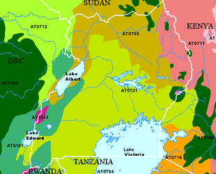 WWF Ecorgions of Uganda. Source WWF
 The following WWF ecoregions are found in Uganda:
- Victoria Basin forest-savanna mosaic (AT0721) covers much of Uganda spreading north and east from Lake Victoria. The ecoregion is most noted for its high species diversity and endemism resulting from the mixture of habitat types and species from both western and eastern Africa. Add the scattered wetland habitat, and you get an abundance of animals representing different habitat types. These include more than 310 species of trees and shrubs, 280 species of birds, 220 species of butterflies, and 100 species of moths. The tropical moist climate here has two rainy seasons--one in April and May and another in October and November. These help replenish the waters for the many wetland areas of the ecoregion.
- East Sudanian savanna (AT0705) reaches down from the north to encompass much of northern Uganda and reaching further south to encompass Lake Albert in the west to near Mount Elgon National Park in the east. This hot, dry, wooded savanna composed mainly of Combretum and Terminalia shrub and tree species and tall elephant grass has been adversely affected by agricultural activities, fire, clearance for wood and charcoal, but large blocks of relatively intact habitat remain even outside protected areas. Populations of some of the larger mammal species have been reduced by hunting, but good numbers of others remain. Although numerous protected areas exist, most are under-resourced "paper parks" with little active enforcement on the ground, and some have suffered from decades of political instability and civil unrest. The poor infrastructure and inaccessibility of the region have resulted in little development of tourism and wildlife-related revenue generation schemes, with the notable exception of sport hunting in the Central African Republic. Considerable external support to this ecoregion from multilateral and bilateral aid agencies is likely to be needed for many years to maintain or improve current levels of biodiversity.
- Albertine Rift montane forests (AT0101) in the west of Urganda represent the largest ecoregion in the Albertine rift, particularly in the middle section. It is an area of exceptional faunal and moderate floral endemism. These mountains also support the Mountain gorilla, which is one of the most charismatic flagship species in Africa, and an effective target for much of the current conservation investment in the area. The area straddles the borders of five different nations, making effective ecoregional conservation a challenge in the area. Although there are a number of National Parks and Forest Reserves in the area, the recent wars have made their management difficult over much of the ecoregion. Additional threats include conversion of most forest areas outside reserves into farmland, together with logging, firewood collection, and bushmeat hunting within the remaining forest areas.
- Ruwenzori-Virunga montane moorlands (AT1013) occur mostly above 9,800 feet (3,000 m) in two areas atop the Ruwenzori and Virunga mountains. Habitat types include lakes at various altitudes, marshy deltas and peat bogs, open montane grasslands, areas of scrub, patches of high elevation forest, glaciers, and even snow fields. It include habitat for the vulnerable mountain gorilla, the Ruwenzori-Virunga Montane Moorlands contain two World Heritage Sites--areas set aside for protection by international treaties.
- East African montane forests (AT0108)are found mostly in Kenya to the east, howver,six smaller area of this ecoregion occur in Uganda, most notably, encircling Mount Elgon on the border with Tanzania. Situated on continuous and isolated mountain ranges, this ecoregion is rich in endemic species, although the numbers of endemics are lower here than in other eastern African mountain ecoregions. The primary threats to the ecoregion come from forest clearance due to an expanding population needing new farmland, and from forest degradation due to a number of exploitative activities, including timber logging.
- Northern Acacia-Commiphora bushlands and thickets (AT0711) cover a large area of eastern Uganda and and across the border in Kenya. The ecoregion, comprised of semi-arid mixed woodland, scrub and grassland, is reasonably protected within a well-functioning system of national parks and other reserves. However, numbers of humans and livestock are increasing outside protected areas, and nomadic pastoralism is declining in favor of settlement, causing environmental degradation through heavy grazing and agricultural expansion. Water is always in short supply in this region, where one or both rainy seasons commonly fail. Certain species such as Grevy’s zebra have undergone severe declines because of competition with livestock for, and often exclusion from, water supplies. Poaching also threatens some of the large herbivores found here, particularly the Black rhinoceros and, until recently, the African elephant.
- Northern Congolian forest-savanna mosaic (AT0712) touches upon a small are of Uganda's western Albertine rift region from the north east where its large extent covers the norther east of the DRC and the south west of Sudan. This narrow transition zone marks an abrupt habitat discontinuity between the extensive Congolian rain forests and Sudanian/Sahelian grasslands. With their characteristically diverse habitat complexes, forest savanna mosaics support a high proportion of ecotonal habitats, which have high species richness and are possible locii of tropical differentiation and speciation.
- East African montane moorlands (AT1005) cover high elevation areas surrounded by East African montane forests, including Mount Eldon. The East African montane moorlands is a relatively small alpine ecoregion in eastern Africa. The habitat is virtually treeless since it occupies a zone above the treeline. This ecoregion, classified as an element of the montane grasslands and scrublands biome, has a land area measuring only about 1300 square miles. The ecoregion, lying at the upper zones of ancient volcanoes, exhibits low species richness of higher level faunal organisms, but manifests moderate plant and animal endemism, including support of certain extremophiles. There is particularly high endemism among amphibians and small mammals of the ecoregion. Many of the plant species that occur in the ecoregion have adapted interesting morphological features to allow survival in the extreme cold here.
See also:
Ecoregions (collection)
Ecoregions of Rwanda (WWF)
Ecoregions of Burundi (WWF)
Ecoregions of Tanzania (WWF)
Ecoregions of Congo, Democratic Republic of (WWF)
Further Reading
- Bailey, Robert G. 2002. Ecoregion-Based Design for Sustainability. Springer-Verlag. New York, New York. 240pp., 100 illus. ISBN 0-387-95430-9
- Bailey, Robert G. 1998. Ecoregions: The Ecosystem Geography of the Oceans and the Continents. Springer-Verlag. New York, New York. 192pp., 107 illus., 10 tables. ISBN 0-387-98305-8
- Bailey, Robert G. 1996. Ecosystem Geography. Springer-Verlag. New York, New York. 216pp., 122 illus., 14 tables. ISBN 0-387-94586-5
- Omernik, James M., 1995. Ecoregions: A spatial framework for environmental management. In: Biological Assessment and Criteria: Tools for Water Resource Planning and Decision Making. Davis, W.S. and T.P. Simon (eds.) Lewis Publishers, Boca Raton, FL. Pp. 49-62. ISBN: 0873718941.
- World Wildlife Fund, Ecoregions homepage, Accessed 1 May 2009.
Return to Uganda country profile
Return to Albertine Rift collection
More African country profiles
Return to the Africa Collection