This level III and IV ecoregion map was compiled at a scale of 1:250,000; it depicts revisions and subdivisions of earlier level III ecoregions that were originally compiled at a smaller scale.[4,2] This poster is the product of a collaborative effort primarily between the USEPA Region VIII, the USEPA National Health and Environmental Effects Research Laboratory (Corvallis, Oregon), North Dakota State Department of Health - Division of Water Quality, South Dakota State Department of Environment and Natural Resources (SDDENR), South Dakota State University (SDSU) - Department of Wildlife and Fisheries (Fisheries and aquaculture) Sciences, the United States Department of Agriculture - Forest Service (USFS), the United States Department of Agriculture - Natural Resources Conservation Service (NRCS) (formerly the Soil Conservation Service), and the United States Department of the Interior - U.S. Geological Survey (USGS) - Earth Resources Observation Systems (EROS) Data Center.
This project is associated with an interagency effort to develop a common frame-work of ecological regions. Reaching that objective requires recognition of the differences in the conceptual approaches and mapping methodologies that have been used to develop the most commonly used existing ecoregion-type frameworks, including those developed by the USFS,[5] the USEPA, [2,3] and the NRCS.[6] As each of these frameworks is further developed, the differences between them lessen. Regional collaborative projects such as this one in North Dakota and South Dakota, where agreement can be reached among multiple resource management agencies, is a step in the direction of attaining commonality and consistency in ecoregion frameworks for the entire nation.
|
17. Middle Rockies
The Middle Rockies ecoregion is characterized by individual mountain ranges of mixed geology interspersed with high elevation, grassy parkland. The Black Hills are an outlier of the Middle Rockies and share with them a montane climate, hydrography, and land use pattern. Ranching and woodland grazing, logging, recreation, and mining are common.
|
|
17a. Two contrasting landscapes, the Hogback Ridge and the Red Valley (or Racetrack), compose the Black Hills Foothills ecoregion. Each forms a concentric ring around the mountainous core of the Black Hills (ecoregions 17b and 17c). Ponderosa pine cover the crest of the hogback and the interior foothills. Buffalo, antelope, deer, and elk still graze the Red Valley grasslands in Custer State Park.
17b. The Black Hills Plateau ecoregion is a relatively flat, elevated expanse covering the mid-elevation slopes and grasslands of the Black Hills. It includes areas of sharply tilted metamorphic rock and lower elevation granite outcrops. Competing uses, such as logging, farming and ranching, and tourist development, stress this ecosystem.
17c. In the Black Hills Core Highlands, higher elevations, cooler temperatures, and increased rainfall foster boreal species such as white spruce, quaking aspen, and paper birch. The mixed geology of this region includes the highest portions of the limestone plateau, areas of schists, slates and quartzites, and large masses of granite that form the most prominent peaks. Mining has increased in the Black Hills Core Highlands after a forty year lull, due to higher gold prices and improved mining technology.
|
 Extensive landscape alteration, surface and ground water contamination, and the high cost of reclamation make surface mining a controversial issue in the Black Hills of South Dakota. Extensive landscape alteration, surface and ground water contamination, and the high cost of reclamation make surface mining a controversial issue in the Black Hills of South Dakota.
|
|
|
|
25. Western High Plains
The Western High Plains ecoregion is a landscape of rolling plains and tablelands formed by the erosion of the Rocky Mountains. Moisture is a limiting factor in the rainshadow of the Rocky Mountains; as a result, the plains vegetation is dominated by drought resistant shortgrass prairie. Farming in this region, once dependent upon rainfall, has been supplemented by irrigation water from the Ogallala Aquifer.
|
|
25a. The Pine Ridge Escarpment forms the boundary between the Missouri Plateau to the north and the High Plains to the south. Ponderosa pine clothe the northern face and the ridgecrest outcrops of sandstone. Cattle graze the rolling grasslands of the Pine Ridge Indian Reservation. A mixed-grass prairie vegetation, rather than shortgrass prairie, dominates this northern extremity of the Western High Plains (25).
|
|
|
|
|
42. Northwestern Glaciated Plains
The Northwestern Glaciated Plains ecoregion marks the westernmost extent of continental glaciation. The youthful morainal landscape has significant surface irregularity and high concentrations of wetlands. The rise in elevation along the eastern boundary defines the beginning of the Great Plains. Land use is transitional between the intensive dryland farming on Ecoregion 46i to the east and the predominance of cattle ranching and farming to the west on the Northwestern Great Plains (43).
|
|
42a. Like closely-spaced ocean swells, the rolling hummocks of the Missouri Coteau enclose countless wetland depressions or potholes. During its slow retreat, the Wisconsinan glacier stalled on the Missouri escarpment for thousands of years, melting slowly beneath a mantle of sediment to create the characteristic pothole topography of the Coteau. The wetlands of the Missouri Coteau and the neighboring prairie pothole regions are the major waterfowl production areas in North America. Land use on the coteau is a mixture of tilled agriculture in flatter areas and grazing land on steeper slopes.
42b. Areas of Collapsed Glacial Outwash formed from gravel and sand deposited by glacial meltwater and precipitation runoff over stagnant ice. Many large, shallow lakes are found in these areas; these lakes and wetlands tend to be slightly to very alkaline depending upon the flowpath of groundwater moving through the permeable outwash deposits. They attract birds preferring large areas of open water, such as white pelicans, black terns, and Forster’s terns, as well as those living in brackish water, such as avocets and tundra swans.
42c. The Missouri Coteau Slope ecoregion declines in elevation from the Missouri Coteau (42a) to the Missouri River. Unlike the Missouri Coteau (42a) where there is a paucity of streams, the Missouri Coteau Slope has a simple drainage pattern and fewer wetland depressions. Due to the level to gently rolling topography, there is more cropland than on the Missouri Coteau (42a). Cattle graze on the steeper land that occurs along drainages.
42d. The Northern Missouri Coteau lies in a transition zone to a more boreal climate to the north and a more arid climate to the west. Willow and aspen, southern outliers of aspen parkland to the north, may occur at wetland margins. Rough fescue, also a northern species, appears in grassland associations. Wetlands tend to dry out earlier in the summer than on the Missouri Coteau (42a) to the south and east. Mixed dryland agriculture is the major land use.
42e. The Southern Missouri Coteau ecoregion, located on the southern fringe of continental glaciation, exhibits a muted coteau topography: gentle undulations rather than steep hummocks, smaller areas of high wetland density, and more stream erosion backcutting into areas of internal drainage. There is more tilled land on the Southern Missouri Coteau than on the Missouri Coteau (42a) because of its gentler topography. More soybeans and corn are planted on the Southern Missouri Coteau due to its milder climate and increased precipitation.
42f. The Southern Missouri Coteau Slope differs from the Missouri Coteau Slope (42c) to the north; it has mesic soils rather than frigid soils and a substantial cap of rock-free loess. To the south, the coteau areas (42a, 42e) east of the Coteau Slope ecoregions (42c, 42f) become progressively narrower and more eroded. The level to rolling uplands of the Southern Missouri Coteau Slope are planted in sunflowers, wheat, millet, and barley. Corn is a marginal crop that does well in wet years. The stream drainages tend to be grazed. Willows, green ash, and elm grow in the riparian areas.
42g. The Ponca Plains comprise a transition area between the more densely settled farmland east of the Missouri River and the sparsely populated rangeland west of the river. Though not glaciated, this “west river” ecoregion resembles the adjacent Southern Missouri Coteau (42e) and Southern Missouri Coteau Slope (42f) in climate, physiography, and land use. Twenty to twenty-two inches of precipitation per year and level to slightly rolling terrain favor intensive rowcrop agriculture.
42h. The Southern River Breaks reflect the more temperate conditions of the southern glaciated plains. Here the draws and northern aspects are heavily wooded with deciduous forest, in contrast to the River Breaks (43c) north of the Big Bend of the Missouri where the riparian woodland forms narrow stringers of juniper and green ash.
42i. The boundary of the Glaciated Dark Brown Prairie region marks a transition to drier conditions. Ecoregion 42i has a well-defined drainage system and fewer wetlands compared to the more recently glaciated Missouri Coteau Slope (42c) to the east. Land use is a mosaic of cropland and rangeland.
|
 A combination of topographic, geologic, and hydrologic factors create varied prairie wetland habitat. A combination of topographic, geologic, and hydrologic factors create varied prairie wetland habitat.
 Pronghorn antelope coexist with cattle on rangeland in the western Dakotas. Pronghorn antelope coexist with cattle on rangeland in the western Dakotas.
 The broken topography of the river breaks provides valuable wildlife habitat. The broken topography of the river breaks provides valuable wildlife habitat.
 The prairie chicken has been extirpated from much of its former range. The prairie chicken has been extirpated from much of its former range.
 High wetland density and hill and swale topography typify the landscape of the Northwestern Glaciated Plains (42). High wetland density and hill and swale topography typify the landscape of the Northwestern Glaciated Plains (42).
|
|
|
|
43. Northwestern Great Plains
The Northwestern Great Plains ecoregion encompasses the Missouri Plateau section of the Great Plains. It is a semiarid rolling plain of shale, siltstone, and sandstone punctuated by occasional buttes and badlands. Native grasslands persist in areas of steep or broken topography, but they have been largely replaced by spring wheat and alfalfa over most of the ecoregion. Agriculture is limited by erratic precipitation patterns and limited opportunities for irrigation.
|
|
43a. On the Missouri Plateau, west of the Missouri River, the landscape opens up to become the “wide open spaces” of the American West. The topography of this ecoregion was largely unaffected by glaciation and retains its original soils and complex stream drainage pattern. A mosaic of spring wheat, alfalfa, and grazing land covers the shortgrass prairie where herds of bison, antelope and elk once grazed.
43b. Theodore Roosevelt once said, “The Badlands look like Poe wrote.” The gothic erosional landscape of the Little Missouri Badlands formed when the Little Missouri River was diverted along a steeper course by Pleistocene [[glacier]s]. The soft silts and clays of the Sentinel Butte and Bullion Creek Formations continually melt off the sparsely vegetated conical hillslopes. The collapse of caverns created by burning coal seams also hastens erosion. Rocky Mountain juniper grows on the hillslopes; cottonwood and green ash appear in the riparian areas. Ephemeral, flashy stream flow creates steep, downcut channels in the soft sediments along the tributaries to the Little Missouri River. Grazing and recreation are the dominant [[land use]s]. This region also includes the Killdeer Mountains.
43c. The River Breaks form broken terraces and uplands that descend to the Missouri River and its major tributaries. They have formed particularly in soft, easily erodible strata, such as Pierre shale. The dissected topography, wooded draws, and uncultivated areas provide a haven for wildlife. Riparian gallery [[forest]s] of cottonwood and green ash persist along major tributaries such as the Moreau and Cheyenne rivers, but they have largely been eliminated along the Missouri River by impoundments.
43d. The Forested Buttes of northwestern South Dakota, outliers of more extensive buttes in Montana, stand 500 feet above the surrounding plains. On closer inspection, the seemingly flat-topped mesas offer a landscape of eroded knobs, hoodoos, and grassy toeslopes capped by ponderosa pine. The higher elevation, locally increased moisture, and variable aspects in the dissected topography are conducive to tree growth. Green ash, boxelder, snowberry, and upland juniper grow in the draws. Cattle, buffalo, mule deer, and antelope share the rangeland.
43e. The Sagebrush Steppe occurs on the dry western edge of North and South Dakota where rainfall rarely exceeds 14 inches per year. Eroded buttes, Hell Creek badlands, scoria (burnt coal) mounds, and salt pans punctuate a thick mat of shortgrass prairie and dusky gray sagebrush. The region is characterized by low human population, minimal cultivation, and relatively high concentrations of wildlife.
43f. A continuous vegetative cover is essential to keep the Subhumid Pierre Shale Plains intact. Tilling the rolling hillsides risks wind and water erosion. Stream channels are deeply incised in its soft, black shale soils and slumping is common along exposed banks.
43g. West of the Cheyenne River, the Semiarid Pierre Shale Plains take on a drier aspect. Although the precipitation is only one or two inches less per year than in ecoregion 43f, successful yields for tilled crops occur more infrequently than they do further east. In this region the mixed-grass prairie has a predominance of shortgrass species, e.g., little bluestem and buffalograss.
43h. The spectacular White River Badlands formed through the erosion of the soft Brule and Chadron clays and siltstones. The turbulent topography ranges from the sheer, highly dissected “Wall” to pastel-hued toeslopes laden with Oligocene fossils. This seemingly barren landscape is broken by grass-covered, perched “sod tables” that may be grazed or tilled.
43i. The Keya Paha Tablelands form a perimeter of sandy, level to rolling plains that surround the steeper dune topography of the Nebraska Sand Hills (44a). Ponderosa pines grow in the drainages in the hilly land east of the Pine Ridge escarpment. Millet and corn grow on the level land, but the sandy soil limits nonirrigated agriculture.
43j. Occasional buttes, areas of badlands, and numerous salt pans appear on the Moreau Prairie. The soils derived from the Hell Creek formation tend to be alkaline, and make this ecoregion less productive agriculturally than the areas surrounding it (ecoregion 43a). Most of the region is grazed by cattle, sheep, and antelope.
43k. The Dense Clay Prairie differs from the surrounding ecoregions in its lack of vegetative cover. The grassland in this ecoregion is missing its short- and mid-level layers. Only the tall [[grass]es] show thinly against the dark-colored clay. Riparian woodland is absent from draws and stream corridors. This fragile landscape must be managed carefully to avoid erosion and blowing soil. Sheep farming is the major land use.
|
 Soft clays of the White River Badlands (43h) form the dramatic erosional landscape of the “Wall.” Soft clays of the White River Badlands (43h) form the dramatic erosional landscape of the “Wall.”
 Bison have been reestablished on public and private land in the western Dakotas. Bison have been reestablished on public and private land in the western Dakotas.
 Overgrazing or tilling the soft shales of ecoregions 43f and 43g risks wind and water erosion. Overgrazing or tilling the soft shales of ecoregions 43f and 43g risks wind and water erosion.
 Sedimentary rocks that contain soft lignite coal underlie much of ecoregion 43a. Lignite within 100 feet of the surface is recoverable by strip mining. Sedimentary rocks that contain soft lignite coal underlie much of ecoregion 43a. Lignite within 100 feet of the surface is recoverable by strip mining.
 Rolling wheat fields, native range, and rural hamlets characterize the Northwestern Great Plains (43). Rolling wheat fields, native range, and rural hamlets characterize the Northwestern Great Plains (43). |
|
|
|
44. Nebraska Sand Hills
The Nebraska Sand Hills ecoregion is the largest grass-stabilized dune region in the Western Hemisphere. This “sand sea” formed in the last 8,000 years, following the Pleistocene glaciations. The region is largely treeless and lacks tilled agriculture. Precipitation passes through the porous sands to continually recharge groundwater, resulting in interdune areas of wetlands, lakes, and streams with a relatively constant annual discharge. The Sand Hills are an important recharge area for the Ogallala aquifer.
|
|
44a. The profile of wavelike dunes on the horizon and a broad expanse of sky characterize this northern outpost of the Nebraska Sand Hills. Cattle ranching is the predominant land use in the region. The prairie grass associations are specific to the sandy environment, but the fragile vegetative cover is susceptible to blowouts, prompting ranchers to employ rotational grazing strategies to maintain it.
|
|
|
|
|
46. Northern Glaciated Plains
The Northern Glaciated Plains ecoregion is characterized by a flat to gently rolling landscape composed of glacial drift. The subhumid conditions foster a grassland transitional between the tall and shortgrass prairie. High concentrations of temporary and seasonal wetlands create favorable conditions for duck nesting and migration. Though the till soil is very fertile, agricultural success is subject to annual climatic fluctuations.
|
|
46a. The Pembina Escarpment is a rugged, forested slope that marks the boundary between the Northern Black Prairies (46g) and the Lake Agassiz Plain (48). Though small, it is a distinctive level IV ecoregion. Originally formed by the undercutting of Cretaceous sandstones by the ancestral Red River, the escarpment was later steepened by glacial scouring. The vista today, of wooded hills with small farms tucked into valleys, is reminiscent of pastoral sections of New England. Streams flowing off the escarpment have high gradients and a cobble substrate.
46b. The undulating landscape and abundant wetlands of the Turtle Mountains are similar to the Missouri Coteau (42a). However, the Turtle Mountains contain larger, deeper, and more numerous lakes. Additionally, this ecoregion receives about 10 inches more precipitation than the surrounding drift plains; thus, it supports a forest cover of aspen, birch, burr oak, elm, and ash. The forest soils are erodible and poorly suited for cropland, though there is some clearing for pastureland.
46c. The Glacial Lake Basins were once occupied by Lake Souris, Devils Lake, and Lake Dakota. These proglacial lakes were formed when major stream or river drainages were blocked by glacial ice during the Pleistocene. The smooth topography of the Glacial Lake Basins, even flatter than the surrounding drift plains (ecoregions 46g, 46i, and 46n), resulted from the slow buildup of water-laid sediments. The level, deep soils on the lake plains are intensively cultivated. In the north, the primary crops are spring wheat, other small grains, and sunflowers; in the Lake Dakota basin of South Dakota, corn and soybeans are more prevalent.
46d. The Glacial Lake Deltas were deposited by rivers entering glacial lake basins (e.g., Glacial Lake Souris, Devils Lake, and Lake Dakota). The heaviest sediments, mostly sand and fine gravel, formed delta fans at the river inlets. As the lake floors were exposed during withdrawal of the glacial ice, wind reworked the sand in some areas into dunes. In contrast to the highly productive, intensively tilled glacial lake plains, the dunes in the delta areas have a thin vegetative cover and a high risk for wind erosion. These areas are used mainly for grazing or irrigated agriculture.
46e. The Tewaukon Dead Ice Moraine is a continuation of the Prairie Coteau (46k) that extends below the level of the Prairie Coteau Escarpment (46l). A high density of semipermanent wetlands provide feeding and nesting habitat for dabbling ducks (blue-winged teal and mallard), and diving ducks (redhead and canvasback). Most upland areas are used for cultivated crops.
46f. The End Moraine Complex is a concentration of glacial features in east central North Dakota. Blue Mountain and Devils Lake Mountain are composed of blocks of surficial material scraped off and thrust up by the continental glacier at the south end of the Devils Lake basin. In the western part of the ecoregion, patches of stagnation moraine similar to the Missouri Coteau (42a) have high wetland densities. On the moraines south of Devils Lake basin, favorable precipitation, aspect, and slightly higher elevations result in wooded lake margins and morainal ridges.
46g. The Northern Black Prairie represents a broad phenological transition zone marking the introduction from the north of a boreal influence in climate. Aspen and birch appear in wooded areas, willows grow on wetland perimeters, and rough fescue, common to the Rocky Mountain foothills, becomes evident in grassland associations. This ecoregion has the shortest growing season and the lowest January temperatures of any Level IV ecoregion (Ecoregions of North Dakota and South Dakota (EPA)) in the Dakotas. Most of the area is used for growing small grains, with durum wheat being a major crop.
46h. The Souris and Des Lacs Rivers generally divide the Northern Dark Brown Prairie from the Northern Black Prairie (46g). These ecoregions differ in precipitation, soil, and vegetation characteristics. The Souris River is within the broad transitional zone between subhumid and semiarid climatic conditions. Soils west of the Souris River developed under drier conditions than those soils further east; they have less organic material which gives them a lighter color. In addition, crop and native grass production is generally lower than in ecoregions further east.
46i. On the Drift Plains, the retreating Wisconsinan glaciers left a subtle undulating topography and a thick mantle of glacial till. A greater proportion of temporary and seasonal wetlands are found on the drift plains than in the coteau areas, where semipermanent wetlands are numerous. Because of the productive soil and level topography, this ecoregion is almost entirely cultivated, with many wetlands drained or simply tilled and planted. However, valuable waterfowl habitat still remains, concentrated in state and federally sponsored duck production areas. The historic grassland on the Drift Plains was a transitional mix of tallgrass and shortgrass prairie. The prairie [[grass]es] have been largely replaced by fields of spring wheat, barley, sunflowers, and alfalfa.
46j. The disjunct areas of Glacial Outwash differ from outwash areas on the Missouri Coteau (42a) in that they generally have a smoother topography. The soils are highly permeable with low water holding capacity. Areas of excessive soil permeability have a poor to fair potential for dryland crop production. Some areas are used for irrigated agriculture. The risk for blowing soil in droughty areas is reduced by retaining native range grasses like little bluestem, needleandthread, and green needlegrass.
46k. The Prairie Coteau ecoregion, like the Missouri Coteau (42a), is the result of stagnant glacial ice melting beneath a sediment layer. The tightly undulating, hummocky landscape has no drainage pattern; it is perforated with closely spaced semipermanent and seasonal wetlands. However, the Prairie Coteau differs from ecoregion 42a in two ways. It has a chain of large lakes that were formed where there was little ice shear, and higher precipitation levels that allow widespread burr oak woodlands near wetland margins.
46l. The Prairie Coteau Escarpment ecoregion, though small, is a distinctive ecosystem, rising 300 to 600 feet in elevation from the Minnesota River valley to the brow of the Prairie Coteau (46k). The elevation, broken topography, and sufficient precipitation favor dense deciduous forest growth in riparian areas. Cool, perennial streams flow off the escarpment, providing [[habitat]s] and oxygenated water not found elsewhere in eastern South Dakota.
46m. The Big Sioux Basin is a trough penetrating the core of the Prairie Coteau (46k). Its topography was affected by pre-Wisconsinan glaciation; later advances of the Wisconsin glacier diverged around the basin. In contrast to the neighboring Prairie Coteau (46k), the basin has a well-developed drainage network. There is more tilled land in the Big Sioux basin due to the relative paucity of wetlands and the gentler topography.
46n. The boundary between the James River Lowland and the Drift Plains (46i) to the north represents a broad phenological and climatic transition zone. This ecoregion is characterized by mesic soils, warmer temperatures, and a longer growing season than the Drift Plains (46i). These differences are reflected in the crop types of the region. Winter wheat, corn, and soybeans are more prevalent in this ecoregion’s milder climate.
46o. Thick glacial drift composes the level terrain of the Minnesota River Prairie. Wetlands are common, though they are fewer and less persistent than those in the neighboring stagnation moraines (ecoregions 46e and 46k). The desiccating [[wind]s] and historic fire regime promoted the prairie ecosystem in this region; however, it is transitional to woodland that occurs to the north and east in Minnesota. Today, the original tallgrass prairie has been replaced by intensive agriculture for grain, corn and soybeans.
|
 The Turtle Mountains (46b pictured above) and the Pembina Escarpment (46a) are the only wooded level IV ecoregions in the Dakotas. The Turtle Mountains (46b pictured above) and the Pembina Escarpment (46a) are the only wooded level IV ecoregions in the Dakotas.
 In cultivated areas, the introduced ringneck pheasant has replaced the prairie chicken as the dominant gamebird. (Photo by South Dakota Tourism) In cultivated areas, the introduced ringneck pheasant has replaced the prairie chicken as the dominant gamebird. (Photo by South Dakota Tourism)
 North and South Dakota rank first and second in the nation for the production of sunflowers for oil. North and South Dakota rank first and second in the nation for the production of sunflowers for oil.
 Near-stream areas are often reserved for grazing and other bovine activities. Near-stream areas are often reserved for grazing and other bovine activities.
 On the drift plains (46g, 46i, and 46n), cultivation occurs around or through the numerous temporary and seasonal wetlands. On the drift plains (46g, 46i, and 46n), cultivation occurs around or through the numerous temporary and seasonal wetlands.
 The prairie pothole regions of North and South Dakota (42 and 46) provide prime nesting and migratory habitat for North American waterfowl. The prairie pothole regions of North and South Dakota (42 and 46) provide prime nesting and migratory habitat for North American waterfowl. |
|
|
|
47. Western Corn Belt Plains
The high agricultural productivity of the Western Corn Belt Plains ecoregion is due to its fertile soil, temperate climate, and adequate precipitation during the growing season. This ecoregion has a relatively homogeneous topography of level to gently rolling glacial till plains with areas of morainal hills and loess deposits. The original tallgrass prairie vegetation has been converted to intensive rowcrop agriculture of corn, soybeans, and feed grains to support livestock production.
|
|
47a. The Loess Prairies of Iowa and South Dakota surround the perimeter of the Des Moines lobe of the Late Wisconsinan glaciation. Of the two areas in South Dakota, the northern one is distinguished from neighboring regions by its rock-free soil and a paucity of wetlands. The southern area is more highly dissected, with deciduous woodland and brush on the steeper slopes and in the draws.
47d. The human development of the Missouri Alluvial Plain over the last two centuries has separated the Missouri River from its floodplain. A system of dams, levees, and stream channelization has largely controlled the flood cycles to allow intensive agriculture in the river bottomland. Much of the northern floodplain forest has been cut, and oxbow lakes and wetlands have been drained to reclaim additional agricultural land.
|
 Corn is the dominant crop in ecoregion 47. Corn is the dominant crop in ecoregion 47.
|
|
|
|
48. Lake Agassiz Plain
Glacial Lake Agassiz was the last in a series of proglacial lakes to fill the Red River Valley since the beginning of the Pleistocene. The Lake Agassiz Plain is composed of thick lacustrine sediments underlain by glacial till. It is extremely flat and has fewer lakes and pothole wetlands than neighboring ecoregions. The historic tallgrass prairie has been replaced by intensive agriculture. The preferred crops in the northern half of the region are potatoes, beans and wheat; soybeans and corn predominate in the south. Sugar beets are grown throughout the region.
|
|
48a. From the Pembina Escarpment (46a), the view of the Glacial Lake Agassiz Basin is of an extremely flat patchwork of cultivated farmland. Because the Red River of the North has a poorly defined floodplain and very low gradient, flooding can be a problem. Outside of channelized areas in the floodplain, turbid valley streams meander within narrow buffer strips of cottonwood, elm, ash, and willow. Soils range from silty to clayey in texture. Most have high water tables and are extremely productive.
48b. The varying relief of the Sand Deltas and Beach Ridges ecoregion interrupts the extremely flat and intensively farmed land of the Lake Agassiz Plain (48). The beach ridges appear as parallel lines of [[sand] and gravel] formed by wave action on the varying shoreline levels of glacial Lake Agassiz. Three sand deltas, the largest being the Sheyenne River delta in the south, occur where major rivers entered glacial Lake Agassiz and dropped their sediment load. A high erosion risk exists in the sand dune areas.
48c. In the Saline Area of the Lake Agassiz basin, salty artesian groundwater flows to the surface through glacial till and lacustrine sediments from the underlying beds of Cretaceous sandstone. The regional boundary of ecoregion 48c delineates an area where salt effects are most evident. Other saline areas occur along the tributaries of the Park, Forest, and Turtle rivers in northeast North Dakota. Salt-affected soils in the saline area reduce crop productivity. Many areas are not suitable for farming, but are used for range or wildlife habitat.
|
 The application of pesticides and fertilizers contributes to nonpoint source water pollution in the Glacial Lake Agassiz Basin (48a). (Photo by South Dakota Tourism) The application of pesticides and fertilizers contributes to nonpoint source water pollution in the Glacial Lake Agassiz Basin (48a). (Photo by South Dakota Tourism) |
 Ecoregions of North Dakota and South Dakota.
 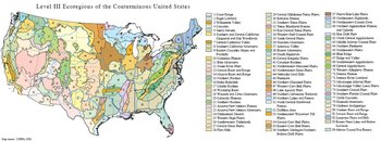 Level III Ecoregions of the Conterminous United States. (Map source: USEPA, 2000)
 (Photo by Jim Swinehart, University of Nebraska)