Ecoregions of Belize
Ecoregions of Countries Collection 
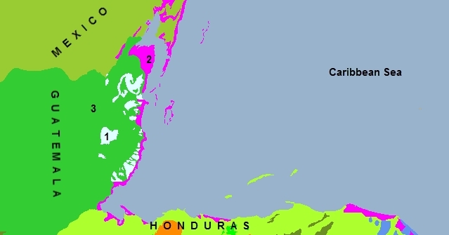
Belize has three major ecoregions
- Belizean pine forests
- Belizean coast mangroves (part of the larger Mesoamerican Gulf-Caribbean mangroves ecoregion)
- Petén-Veracruz moist forests
Contents
Belizean pine forests
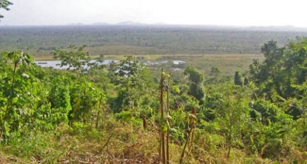
[[The Belizean pine forests on Central America's northwestern Caribbean coast represent various relatively well preserved fragments of vegetation as well as a considerable abundance of fauna. This ecoregion comprises a geographically small portion of the total land area of the]]ecoregions of Belize. They represent one of the few examples of lowland and premontane pine forests in the Neotropics, where the dominant tree species is Honduran Pine (Pinus caribaea var. hondurensis), which requires periodic low intensity burns for its regeneration. The vegetation is adapted to the xeric, acidic and nutrient-poor conditions that occur primarily in the dry season. The coastal areas of the ecoregion, with vegetation that is less dense, are somewhat threatened due to selective forestry operations and the expansion of citrus fruit and banana plantations.
This ecoregion has a level II biodiversity priority (high priority on the regional level). This ecoregion is felt to have a relatively stable conservation status, and corresponds to one of the best represented ecoregions in the region. Its biological singularity is important at the bioregional level. There are no concrete figures for determining the ecoregions conservation status because sufficient high-quality data are not available. More than 70% of the closed pine forests are found in forest reserves while only 25% of the pine savanna areas are found in protected areas. The regions around the central fragment are also protected. Sustainable lumber operations are being carried out in the reserve in the Mountain Pine strip; if this continues as at present it could ensure a long-term domestic supply of soft wood. The protected areas are relatively large compared to the area occupied by the ecoregion, and the protection system is one of the best in the region.
Belizean coast mangroves
The Belizean coast mangrovesecoregion (part of the larger Mesoamerican Gulf-Caribbean mangroves ecoregion) extends along the Caribbean Coast from Guatemala, encompassing the mangrove habitat along the shores of the Bahía de Annatique; this ecoregion continues along the Belizean coast up to the border with Mexico. This ecoregion is threatened by expanding tourism on the coastal areas of Belize alsong with growth in indigenous human populations. The presence of mangroves on the coastal fringe becomes more prevalent along the more southern reaches of the Belizean coastline.
The ecoregion is experiencing ongoing damage to the mangrove systems driven by an expanding indigenous human population as well as increases in tourism. Specific articulations of these phenomenona include the obliteration of the mangrove habitat at Belize City and urban coastal encroachment along the Placencia Peninsula, where hotel and condominium development are proceeding at a rapid pace. In addition disposal of solid waste debris near indigenous human settlements are polluting mangrove habitat as well as interspersed beach areas.
Petén-Veracruz moist forests
The Petén-Veracruz moist forests is a moist broadleaf forest ecoregion in generally mountainous terrain that extends from northern Belize northward through parts of Guatemala and into southern Mexico. This forested ecoregion covers an area of approximately 149,100 square kilometres. Endemism of this ecoregion is relatively low, but species richness is high.
This ecoregion is critically endangered due to relentless encroachment of the human population, particularly from the overpopulated portions of the forests that lie in Guatemala and southern Mexico; conversely, the nation of Belize has kept its population within the land's carrying capacity and has a strong national ethic of environmental protection.
At the south the Petén-Veracruz moist forests are bounded by a broad [[coastal] ]plain and southern foothills of the Mayan Mountains; the Belizean pine forest ecoregion is established at this southern limit, although much of the pine forest here presents as a savanna.
Major southern rivers in the Belize portion of the ecoregion include the Mopan and Macal Rivers; the Macal cuts through dense jungle, and provided the chief transportation link for ancient Mayans in the region.
Mayan prehistory
Thousands of years before the present, Mayan settlers arrived from the north (present day Guatemala). These early peoples developed a highly sophisticated civilization in cities at the edge of the Belizean pine forests, in the foothills of the Mayan Mountains, as well as in the higher reaches of the western Maya Mountains. Ruins of such cities as Lubaantun and Nim li Punit are visible today, as testaments to the architectural skills of these early stone builders. One of the chief uses of the Belizean pine forests was a travel route for water based trade with their ancestral tribes to the north. These Mayans were skillful canoers, and made use of the low gradient rivers descending from the Mayan Mountains as they prior to discharge to the sea. After the river journey, the Mayan canoers would continue on by sea to reach the northern lands, where they traded pottery and agricultural commodities.
Context
Ecoregions are areas that:
[1] share a large majority of their species and ecological dynamics;
[2] share similar environmental conditions; and,
[3] interact ecologically in ways that are critical for their long-term persistence.
Scientists at the World Wildlife Fund (WWF), have established a classification system that divides the world in 867 terrestrial ecoregions, 426 freshwater ecoregions and 229 marine ecoregions that reflect the distribution of a broad range of fauna and flora across the entire planet.
References
- Daniel M.Alongi. 2009. The energetics of mangrove forests. 216 pages
- Les Beletsky and David Beadle. 2005. Belize & Northern Guatemala. Interlink Books. 477 pages
- Luiz Drude de Lacerda. 2002. Mangrove ecosystems: function and management. Springer. 292 pages
- Alistar I.Robertson and Daniel M.Alongi. 1991. Tropical mangrove ecosystems. American geophysical Union. 329 pages
- E.Carrillo and C.Vaughan, eds. 1994. La vida silvestre de mesoamérica: Diagnóstico y estrategia para su conservación. Editorial Universidad Nacional, Heredia, Costa Rica.
- E.Dinerstein, D.M.Olson, et al. 1995. A Conservation Assessment of the Terrestrial Ecoregions of Latin America and the Caribbean. The World Bank in association with WWF, Washington, D.C. ISBN: 0821332961
- Jonathan A.Campbell. 1999. Amphibians and Reptiles of Northern Guatemala, the Yucatan, and Belize. University of Oklahoma Press. 400 pages
- Gonzalo Castro and Ilana Locker. 2000. Mapping conservation investments: an assessment of biodiversity funding in Latin America and the Caribbean. Biodiversity Support Program. 79 pages
- C.Michael Hogan. 2007. Lubaantun. The Megalithic Portal. ed. A.Burnham
- Roger Tory Peterson, Edward L. Chalif. 1999. A Field Guide to Mexican Birds: Mexico, Guatemala, Belize, El Salvador. Houghton Mifflin Harcourt. 320 pages

